

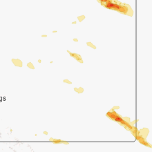
Hail Map for Monday, August 5, 2013

Number of Impacted Households on 8/5/2013
0
Impacted by 1" or Larger Hail
0
Impacted by 1.75" or Larger Hail
0
Impacted by 2.5" or Larger Hail
Square Miles of Populated Area Impacted on 8/5/2013
0
Impacted by 1" or Larger Hail
0
Impacted by 1.75" or Larger Hail
0
Impacted by 2.5" or Larger Hail


Cities Most Affected by Hail Storms of 8/5/2013
| Hail Size | Demographics of Zip Codes Affected | ||||||
|---|---|---|---|---|---|---|---|
| City | Count | Average | Largest | Pop Density | House Value | Income | Age |
| Alzada, MT | 4 | 2.00 | 2.50 | 0 | $138k | $33.8k | 52.5 |
| Ingalls, KS | 3 | 2.08 | 2.75 | 1 | $71k | $39.0k | 35.9 |
| Belle Fourche, SD | 1 | 1.75 | 1.75 | 6 | $67k | $30.1k | 39.3 |
| Ozark, MO | 1 | 1.75 | 1.75 | 300 | $99k | $38.6k | 34.6 |
| Vida, MT | 1 | 1.75 | 1.75 | 0 | $66k | $27.1k | 53.2 |
| Ava, MO | 1 | 1.75 | 1.75 | 18 | $55k | $25.9k | 44.4 |
| Hayes Center, NE | 1 | 1.75 | 1.75 | 1 | $34k | $26.9k | 47.0 |
| Shelby, MT | 1 | 1.75 | 1.75 | 3 | $65k | $30.2k | 41.1 |
| Custer, SD | 1 | 1.75 | 1.75 | 8 | $92k | $36.7k | 51.5 |
| Yuma, CO | 1 | 1.75 | 1.75 | 7 | $84k | $32.3k | 37.1 |
Hail and Wind Damage Spotted on 8/5/2013
Filter by Report Type:Hail ReportsWind Reports
States Impacted
Iowa, Florida, Montana, Utah, Kansas, Georgia, Mississippi, Idaho, Wyoming, Nebraska, South Dakota, Missouri, New Mexico, Arkansas, North Dakota, ColoradoIowa
| Local Time | Report Details |
|---|---|
| 8:00 AM CDT | Small twigs and branches off of trees. estimated 45 mph winds with occasional higher gusts. heavy downpours reducing visibility to a few blocks in distanc in buchanan county IA, 36 miles NNW of Cedar Rapids, IA |
Florida
| Local Time | Report Details |
|---|---|
| 2:35 PM EDT | A large tree was uprooted in the cove subdivision near goldenrod. broadcast media also relayed images of several large broken tree limbs and damaged pool enclosures. re in orange county FL, 7.8 miles ENE of Orlando, FL |
Montana
| Local Time | Report Details |
|---|---|
| 1:40 PM MDT | Quarter sized hail reported near Shelby, MT, 78.6 miles NNW of Great Falls, MT, quarter sized hail reported near the glacier wind farm. |
| 2:40 PM MDT | Quarter sized hail reported near Ledger, MT, 55.7 miles N of Great Falls, MT |
| 3:02 PM MDT | Quarter sized hail reported near Havre, MT, 0.5 miles WSW of Havre, MT, hail ranging from pea to quarter sized. |
| 3:05 PM MDT | Half Dollar sized hail reported near Malta, MT, 64.4 miles WNW of Glasgow, MT |
| 3:25 PM MDT | Quarter sized hail reported near Cut Bank, MT, 94.2 miles NNW of Great Falls, MT, quarter sized hail covering the ground. |
| 3:28 PM MDT | Quarter sized hail reported near Loma, MT, 51.7 miles NE of Great Falls, MT, nickel to quarter size hail. 50 mph winds. |
| 3:35 PM MDT | Golf Ball sized hail reported near Shelby, MT, 86.9 miles NNW of Great Falls, MT, golf ball sized hail. crop damage. |
| 3:57 PM MDT | Possible microburst from a collapsing stor in carbon county MT, 27.4 miles SW of Billings, MT |
| 4:00 PM MDT | Winds estimated to at least 60 mph. several tree branches down. peas size hail and .75 rainfal in chouteau county MT, 47.2 miles SSW of Havre, MT |
| 4:30 PM MDT | 68 mph thunderstorm wind gust a few miles north of galata. time of event is estimate in toole county MT, 71.4 miles N of Great Falls, MT |
| 4:30 PM MDT | Golf Ball sized hail reported near Vida, MT, 61.1 miles ESE of Glasgow, MT, hail lasted for 2 minutes. ended at 430 pm. |
| 4:50 PM MDT | Quarter sized hail reported near Larslan, MT, 29.9 miles NNE of Glasgow, MT |
| 5:03 PM MDT | Sustained wind at 44 mph in custer county MT, 2.5 miles NW of Miles City, MT |
| 5:15 PM MDT | Some 5 inch limbs down on chain link fence. minor tree damage around tow in custer county MT, 0.5 miles ENE of Miles City, MT |
| 5:30 PM MDT | Power poles north of their property were knocked down. power was out for several hour in richland county MT, 55.1 miles WSW of Williston, ND |
| 5:35 PM MDT | Part of a roof on a home torn of in roosevelt county MT, 66.4 miles E of Glasgow, MT |
| 5:40 PM MDT | Quarter sized hail reported near Miles City, MT, 36.8 miles SE of Miles City, MT |
| 5:43 PM MDT | Tree branches in roosevelt county MT, 67.1 miles E of Glasgow, MT |
| 6:14 PM MDT | Tree branches in roosevelt county MT, 67.1 miles E of Glasgow, MT |
| 6:15 PM MDT | Storm damage reported in fallon county MT, 63 miles E of Miles City, MT |
| 6:39 PM MDT | Power flickering on and of in richland county MT, 40.9 miles WSW of Williston, ND |
| 6:40 PM MDT | Measured at cannonball creek raws in fallon county MT, 83.7 miles E of Miles City, MT |
| 6:55 PM MDT | Storm damage reported in carter county MT, 95.9 miles NE of Gillette, WY |
| 6:55 PM MDT | Golf Ball sized hail reported near Alzada, MT, 95.9 miles NE of Gillette, WY |
| 7:00 PM MDT | Storm damage reported in carter county MT, 89.3 miles NNE of Gillette, WY |
| 7:00 PM MDT | Hen Egg sized hail reported near Alzada, MT, 89.3 miles NNE of Gillette, WY, hen egg hail stripped siding and screens from house. |
| 7:15 PM MDT | Tennis Ball sized hail reported near Alzada, MT, 90.1 miles NE of Gillette, WY, broken windows in house. |
| 7:15 PM MDT | Quarter sized hail reported near Alzada, MT, 85.7 miles NE of Gillette, WY |
| 7:15 PM MDT | Golf Ball sized hail reported near Alzada, MT, 88.1 miles NE of Gillette, WY |
Utah
| Local Time | Report Details |
|---|---|
| 1:45 PM MDT | Near the intersection of utah state route 111 and new bingham highway...rocky mountain power reports an estimated 37 transmission poles and 23 distribution poles were k in salt lake county UT, 15.9 miles SW of Salt Lake City, UT |
Kansas
| Local Time | Report Details |
|---|---|
| 2:11 PM MDT | Quarter sized hail reported near Goodland, KS, 40.2 miles WSW of Colby, KS |
| 2:20 PM MDT | Quarter sized hail reported near Wallace, KS, 32.3 miles SW of Colby, KS, heavy rainfall observed. |
| 3:54 PM CDT | Quarter sized hail reported near Winona, KS, 35.7 miles SSW of Colby, KS, heavy rainfall and gusty winds were observed. some small branches were blown to the ground. |
| 4:35 PM CDT | Storm damage reported in scott county KS, 49.8 miles N of Garden City, KS |
| 4:57 PM CDT | Storm damage reported in lane county KS, 48.9 miles NNE of Garden City, KS |
| 5:07 PM CDT | Also pea sized hail and small tree damage in lane county KS, 45.6 miles NNE of Garden City, KS |
| 5:10 PM CDT | Several 4 inch tree branches broken...some 6 to 8 inch tree branches broke. also semi blown off of road in lane county KS, 45.6 miles NNE of Garden City, KS |
| 5:18 PM CDT | Also pea sized hail...very heavy rain...and visibilities less than a quarter of a mil in lane county KS, 45.7 miles NNE of Garden City, KS |
| 5:59 PM CDT | Also had 4-5 inch branches broken on his tree in clark county KS, 51.2 miles NNW of Woodward, OK |
| 6:23 PM CDT | Storm damage reported in ness county KS, 42.7 miles SW of Hays, KS |
| 6:45 PM CDT | Storm damage reported in clark county KS, 53.7 miles NNW of Woodward, OK |
| 6:45 PM CDT | Quarter sized hail reported near Lake City, KS, 57.7 miles NNE of Woodward, OK |
| 7:07 PM CDT | Storm damage reported in barber county KS, 73.7 miles WSW of Wichita, KS |
| 7:10 PM CDT | Storm damage reported in hodgeman county KS, 57.3 miles E of Garden City, KS |
| 7:30 PM CDT | Quarter sized hail reported near Garden City, KS, 10.9 miles SSE of Garden City, KS |
| 7:46 PM CDT | Storm damage reported in kingman county KS, 54.1 miles WSW of Wichita, KS |
| 7:58 PM CDT | Spotter reported that their power was out and estimated winds of 50 mph along with very heavy rainfal in kingman county KS, 51.7 miles WSW of Wichita, KS |
| 8:05 PM CDT | Storm damage reported in edwards county KS, 71.9 miles S of Hays, KS |
| 8:05 PM CDT | Golf Ball sized hail reported near Ingalls, KS, 22.9 miles SE of Garden City, KS |
| 8:08 PM CDT | Baseball sized hail reported near Ingalls, KS, 21.5 miles SE of Garden City, KS |
| 8:10 PM CDT | Golf Ball sized hail reported near Ingalls, KS, 27.6 miles ESE of Garden City, KS |
| 8:35 PM CDT | This was an estimated wind speed from a spotter that was reporting to the emergency manager. damage from this high of wind speed was not yet reported i in pratt county KS, 83.6 miles W of Wichita, KS |
| 8:50 PM CDT | Numerous powerlines down in and around pratt. the entire city of pratt was without power as well as cullison and iuka. numerous trees were also reported down from culli in pratt county KS, 77 miles W of Wichita, KS |
| 8:52 PM CDT | Can hear limbs cracking in the background in pratt county KS, 75.9 miles W of Wichita, KS |
| 9:00 PM CDT | Storm damage reported in pratt county KS, 73.7 miles W of Wichita, KS |
| 9:08 PM CDT | 12 inch diameter trees reported down at nw 10th street and 70th av in pratt county KS, 77.1 miles W of Wichita, KS |
| 9:09 PM CDT | Storm damage reported in pratt county KS, 68.8 miles W of Wichita, KS |
| 9:10 PM CDT | Storm damage reported in kingman county KS, 60.1 miles W of Wichita, KS |
| 9:41 PM CDT | Spotter estimated 50 to 60 mph winds in kingman county KS, 54 miles W of Wichita, KS |
| 10:06 PM CDT | Delayed report from the newton airport in harvey county KS, 24.3 miles N of Wichita, KS |
| 10:11 PM CDT | Estimated 70 to 80 mph on the southwest side of newton in harvey county KS, 24.3 miles N of Wichita, KS |
| 10:13 PM CDT | Storm damage reported in butler county KS, 27.4 miles NNE of Wichita, KS |
| 10:20 PM CDT | Delayed report of an estimated 65 mph winds with tree branches down as the storm moved through whitewate in butler county KS, 21.4 miles NNE of Wichita, KS |
| 10:25 PM CDT | Spotter estimated 50 to 60 mph winds with torrential rainfall in butler county KS, 25.3 miles NE of Wichita, KS |
| 10:26 PM CDT | Storm damage reported in harvey county KS, 20.9 miles NNE of Wichita, KS |
| 10:30 PM CDT | Reports of docks tossed around and flipped over at the shady creek marina. time estimated from rada in butler county KS, 32.2 miles ENE of Wichita, KS |
| 10:35 PM CDT | Storm damage reported in butler county KS, 18.7 miles NE of Wichita, KS |
| 10:35 PM CDT | Report of a camper overturned at campground with no reports of injuries. time estimated from radar in butler county KS, 32.2 miles ENE of Wichita, KS |
| 10:35 PM CDT | Report of a camper overturned at campground with nor reports of injuries. time estimated from radar in butler county KS, 32.2 miles ENE of Wichita, KS |
| 10:42 PM CDT | Measured 61 mph gust at el dorado high school in butler county KS, 27.6 miles ENE of Wichita, KS |
| 10:46 PM CDT | Trained spotter reported winds of 60 mph with very heavy rainfall in butler county KS, 27.6 miles ENE of Wichita, KS |
| 10:46 PM CDT | 10 inch diameter tree down in butler county KS, 27.6 miles ENE of Wichita, KS |
| 10:52 PM CDT | Storm damage reported in butler county KS, 19.6 miles E of Wichita, KS |
| 11:13 PM CDT | Emergency manager reports 30 inch diameter tree uprooted at the country club and a few of similar size could be found uprooted in town as wel in greenwood county KS, 46.9 miles WNW of Chanute, KS |
| 11:13 PM CDT | One 8 to 10 inch tree down with several smaller trees blocking roadways. time based on radar in greenwood county KS, 46.9 miles WNW of Chanute, KS |
| 11:29 PM CDT | Trees down on a house and a ca in greenwood county KS, 46.9 miles WNW of Chanute, KS |
| 11:38 PM CDT | Law enforcement estimated 70-75mph wind gusts at eureka lak in greenwood county KS, 47.9 miles WNW of Chanute, KS |
| 11:58 PM CDT | Numerous trees downed across the roads in the count in elk county KS, 46.7 miles WSW of Chanute, KS |
| 12:09 AM CDT | Storm damage reported in wilson county KS, 22.8 miles WSW of Chanute, KS |
| 12:10 AM CDT | Storm damage reported in chautauqua county KS, 53 miles SW of Chanute, KS |
| 1:30 AM CDT | Large limbs blown down in devon along with 1.96 inches of rainfall in about an hour in bourbon county KS, 38.3 miles ENE of Chanute, KS |
Georgia
| Local Time | Report Details |
|---|---|
| 4:25 PM EDT | Quarter sized hail reported near Swainsboro, GA, 71.1 miles NNE of Douglas, GA, the public reported quarter sized hail between nunez and oak park. |
Mississippi
| Local Time | Report Details |
|---|---|
| 4:30 PM CDT | Power lines reported down in the diberville are in harrison county MS, 55 miles WSW of Mobile, AL |
| 4:45 PM CDT | Large trees down om power lines. roof damge to she in wayne county MS, 71.8 miles NNW of Mobile, AL |
Idaho
| Local Time | Report Details |
|---|---|
| 3:48 PM MDT | Weakened trees downed and a power line downed. time approxiamte and coincident with weak radar returns near lava hot spring in bannock county ID, 60.2 miles S of Idaho Falls, ID |
| 4:19 PM MDT | Semi-truck blown off road near downey. report time approximate and coincident with weak cell passing through area on radar. neaby mesonet wind gust to 32 mph at malad s in bannock county ID, 73.4 miles S of Idaho Falls, ID |
| 4:20 PM MDT | Dale bitner raws. time of event estimated coincident with weak radar echoes moving through the area. wind gust occurred sometime between 1546 and 1645 md in bonneville county ID, 44.4 miles SE of Idaho Falls, ID |
Wyoming
| Local Time | Report Details |
|---|---|
| 4:16 PM MDT | Quarter sized hail reported near Upton, WY, 41.9 miles ESE of Gillette, WY |
| 4:31 PM MDT | Quarter sized hail reported near Gillette, WY, 4.9 miles NE of Gillette, WY |
| 5:05 PM MDT | Quarter sized hail reported near Upton, WY, 44.3 miles ESE of Gillette, WY |
| 5:10 PM MDT | Quarter sized hail reported near Moorcroft, WY, 29 miles E of Gillette, WY |
| 5:20 PM MDT | Quarter sized hail reported near Moorcroft, WY, 28.9 miles E of Gillette, WY |
Nebraska
| Local Time | Report Details |
|---|---|
| 5:50 PM CDT | Quarter sized hail reported near Wellfleet, NE, 22.6 miles S of North Platte, NE |
| 6:20 PM CDT | Golf Ball sized hail reported near Hayes Center, NE, 44 miles SSW of North Platte, NE, corn field is damaged and the ground is white from the hail. |
| 6:40 PM CDT | Quarter sized hail reported near Palisade, NE, 53.2 miles SSW of North Platte, NE |
| 5:55 PM MDT | Quarter sized hail reported near Wauneta, NE, 52.6 miles SW of North Platte, NE |
| 7:25 PM CDT | Quarter sized hail reported near Wauneta, NE, 59.6 miles SSW of North Platte, NE |
| 7:37 PM CDT | Quarter sized hail reported near Palisade, NE, 60.8 miles SSW of North Platte, NE |
| 8:05 PM CDT | Ping Pong Ball sized hail reported near Stratton, NE, 60.2 miles NNW of Colby, KS |
| 8:30 PM CDT | Quarter sized hail reported near Stratton, NE, 52.9 miles N of Colby, KS |
| 8:38 PM CDT | Large branches were reported down across highway 30 just west of the airpor in lincoln county NE, 0.8 miles ESE of North Platte, NE |
| 8:42 PM CDT | Storm damage reported in lincoln county NE, 2.8 miles E of North Platte, NE |
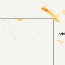
South Dakota
| Local Time | Report Details |
|---|---|
| 5:50 PM MDT | Quarter sized hail reported near Hill City, SD, 22.7 miles SW of Rapid City, SD |
| 5:50 PM MDT | Golf Ball sized hail reported near Custer, SD, 23.9 miles SW of Rapid City, SD |
| 6:10 PM MDT | Quarter sized hail reported near Keystone, SD, 20.6 miles SSW of Rapid City, SD |
| 6:20 PM MDT | Quarter sized hail reported near Hermosa, SD, 21.5 miles SSW of Rapid City, SD |
| 6:55 PM MDT | Storm damage reported in harding county SD, 95.4 miles ESE of Miles City, MT |
| 7:08 PM MDT | Storm damage reported in harding county SD, 105.3 miles ESE of Miles City, MT |
| 7:30 PM MDT | Dime-sized hail also in harding county SD, 95.5 miles NNW of Rapid City, SD |
| 7:45 PM MDT | Storm damage reported in harding county SD, 96.9 miles N of Rapid City, SD |
| 7:57 PM MDT | Storm damage reported in harding county SD, 87.6 miles N of Rapid City, SD |
| 8:09 PM MDT | Golf Ball sized hail reported near Belle Fourche, SD, 60.5 miles NNW of Rapid City, SD |
| 8:15 PM MDT | Storm damage reported in harding county SD, 82.6 miles N of Rapid City, SD |
| 8:25 PM MDT | Storm damage reported in butte county SD, 71.1 miles N of Rapid City, SD |
| 8:35 PM MDT | Storm damage reported in perkins county SD, 76.8 miles NNE of Rapid City, SD |
| 8:40 PM MDT | Storm damage reported in perkins county SD, 76.5 miles NNE of Rapid City, SD |
| 8:50 PM MDT | Storm damage reported in meade county SD, 67.4 miles NNE of Rapid City, SD |
| 9:20 PM MDT | Storm damage reported in meade county SD, 55.3 miles NE of Rapid City, SD |
| 9:20 PM MDT | Storm damage reported in meade county SD, 43.2 miles NE of Rapid City, SD |
| 9:26 PM MDT | Storm damage reported in meade county SD, 79.2 miles NE of Rapid City, SD |
| 9:30 PM MDT | Storm damage reported in ziebach county SD, 79 miles WNW of Pierre, SD |
| 9:50 PM MDT | Storm damage reported in haakon county SD, 63.7 miles W of Pierre, SD |
| 10:00 PM MDT | Storm damage reported in haakon county SD, 66.4 miles W of Pierre, SD |
| 10:30 PM MDT | Cocorahs report of 60 mph winds at residenc in stanley county SD, 44.3 miles WNW of Pierre, SD |
| 10:30 PM MDT | Also reported pea size hail with the winds in stanley county SD, 39.7 miles W of Pierre, SD |
| 11:17 PM MDT | Flag ripped from flagpole and pole slightly bent in pennington county SD, 2.8 miles NNW of Rapid City, SD |
| 1:20 AM MDT | Storm damage reported in jackson county SD, 72.3 miles ESE of Rapid City, SD |
| 2:00 AM MDT | Storm damage reported in jackson county SD, 69.7 miles NW of Valentine, NE |
| 3:55 AM CDT | Storm damage reported in todd county SD, 29.8 miles N of Valentine, NE |
Missouri
| Local Time | Report Details |
|---|---|
| 6:55 PM CDT | Golf Ball sized hail reported near Ava, MO, 35.5 miles ESE of Springfield, MO |
| 6:55 PM CDT | Quarter sized hail reported near Rogersville, MO, 16 miles SE of Springfield, MO |
| 6:56 PM CDT | Quarter sized hail reported near Springfield, MO, 2.7 miles SE of Springfield, MO, mostly dime sized hail with an occasional quarter size. |
| 7:04 PM CDT | Quarter sized hail reported near Ozark, MO, 10.4 miles SSE of Springfield, MO, delayed report from monday evening. |
| 7:04 PM CDT | Golf Ball sized hail reported near Ozark, MO, 10.8 miles SSE of Springfield, MO, delayed report from monday evening. |
| 7:11 PM CDT | Multiple trees down and minor roof damage reporte in christian county MO, 22 miles SE of Springfield, MO |
| 7:44 PM CDT | Numerous trees and power poles were down. some locations were without powe in ozark county MO, 49.9 miles SE of Springfield, MO |
| 7:55 PM CDT | Trees down between theodosia and isabella on highway 16 in ozark county MO, 55 miles SE of Springfield, MO |
| 8:02 PM CDT | Trees reported down in theodosia. roof damaged directly across the lake to the east of theodosia. trees reported down in isabela als in ozark county MO, 55 miles SE of Springfield, MO |
| 8:07 PM CDT | Several large trees and powerlines down between forsyth and taneyvill in taney county MO, 34.2 miles SSE of Springfield, MO |
| 8:16 PM CDT | Half Dollar sized hail reported near Taneyville, MO, 38.2 miles SSE of Springfield, MO |
| 8:34 PM CDT | Numerous trees down at 160 in ruete in taney county MO, 46.9 miles SSE of Springfield, MO |
| 8:39 PM CDT | Trees reported dow in taney county MO, 35.4 miles SSE of Springfield, MO |
| 8:50 PM CDT | Trees and power lines reported down in and around prote in taney county MO, 52.6 miles SSE of Springfield, MO |
| 2:00 AM CDT | Large tree branch over the road near the intersection of main street and ewing stree in vernon county MO, 61.3 miles E of Chanute, KS |
| 2:00 AM CDT | Tree uprooted and power pole broken. time estimate in vernon county MO, 63.7 miles E of Chanute, KS |
| 3:15 AM CDT | Large tree limbs down. delayed repor in cass county MO, 21 miles SSE of Kansas City, MO |
New Mexico
| Local Time | Report Details |
|---|---|
| 6:00 PM MDT | Large pine tree blown over on garver lan in los alamos county NM, 54.1 miles SW of Taos, NM |
Arkansas
| Local Time | Report Details |
|---|---|
| 8:28 PM CDT | Trees reported dow in baxter county AR, 70.7 miles SE of Springfield, MO |
| 8:31 PM CDT | Tree fell an a car and trees down in the are in baxter county AR, 71.5 miles SE of Springfield, MO |
| 8:45 PM CDT | Quarter sized hail reported near Mountain Home, AR, 78.4 miles SE of Springfield, MO |
| 9:53 PM CDT | Trees down along hwy 5 nort in stone county AR, 80.6 miles N of Little Rock, AR |
| 10:03 PM CDT | Trees down along hwy 66 wes in stone county AR, 77.3 miles N of Little Rock, AR |
North Dakota
| Local Time | Report Details |
|---|---|
| 7:30 PM MDT | 7 n and 3 e of scranton. 60 mph wind in bowman county ND, 113.3 miles WSW of Bismarck, ND |
Colorado
| Local Time | Report Details |
|---|---|
| 7:30 PM MDT | Golf Ball sized hail reported near Yuma, CO, 11.1 miles N of Yuma, CO |
Connect with Interactive Hail Maps