

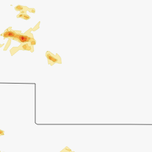
Hail Map for Wednesday, June 4, 2014

Number of Impacted Households on 6/4/2014
0
Impacted by 1" or Larger Hail
0
Impacted by 1.75" or Larger Hail
0
Impacted by 2.5" or Larger Hail
Square Miles of Populated Area Impacted on 6/4/2014
0
Impacted by 1" or Larger Hail
0
Impacted by 1.75" or Larger Hail
0
Impacted by 2.5" or Larger Hail


Cities Most Affected by Hail Storms of 6/4/2014
| Hail Size | Demographics of Zip Codes Affected | ||||||
|---|---|---|---|---|---|---|---|
| City | Count | Average | Largest | Pop Density | House Value | Income | Age |
| Mcpherson, KS | 2 | 2.50 | 3.00 | 67 | $86k | $42.0k | 39.9 |
| Belle Fourche, SD | 2 | 2.50 | 2.50 | 6 | $67k | $30.1k | 39.3 |
| Agate, CO | 2 | 2.38 | 2.75 | 1 | $131k | $40.7k | 50.9 |
| Clearwater, KS | 1 | 2.75 | 2.75 | 46 | $99k | $52.0k | 39.0 |
| Galva, KS | 1 | 2.75 | 2.75 | 16 | $81k | $42.6k | 36.6 |
| Madison, WV | 1 | 2.00 | 2.00 | 136 | $81k | $30.4k | 42.0 |
| Sheridan, WY | 1 | 1.75 | 1.75 | 36 | $103k | $34.3k | 40.9 |
| Great Bend, KS | 1 | 1.75 | 1.75 | 78 | $61k | $33.4k | 38.0 |
| Lampe, MO | 1 | 1.75 | 1.75 | 63 | $110k | $35.3k | 52.8 |
| Aurora, MO | 1 | 1.75 | 1.75 | 75 | $62k | $27.4k | 39.7 |
| Flagler, CO | 1 | 1.75 | 1.75 | 1 | $74k | $30.4k | 46.7 |
| Limon, CO | 1 | 1.75 | 1.75 | 2 | $88k | $35.1k | 38.2 |
| Cassville, MO | 1 | 1.75 | 1.75 | 50 | $68k | $29.0k | 41.0 |
| Cape Fair, MO | 1 | 1.75 | 1.75 | 24 | $74k | $27.2k | 55.8 |
| Alzada, MT | 1 | 1.75 | 1.75 | 0 | $138k | $33.8k | 52.5 |
| Monett, MO | 1 | 1.75 | 1.75 | 137 | $72k | $32.5k | 35.5 |
| Biddle, MT | 1 | 1.75 | 1.75 | 0 | $43k | $24.2k | 48.5 |
Hail and Wind Damage Spotted on 6/4/2014
Filter by Report Type:Hail ReportsWind Reports
States Impacted
Ohio, North Carolina, West Virginia, Kentucky, Montana, Wyoming, Virginia, South Dakota, Illinois, North Dakota, Tennessee, Nebraska, Colorado, Missouri, KansasOhio
| Local Time | Report Details |
|---|---|
| 11:51 AM EDT | Several trees down along upper twin creek road. time estimated from rada in scioto county OH, 73.8 miles ESE of Cincinnati, OH |
| 12:23 PM EDT | One large tree fell on car. time estimated from rada in scioto county OH, 68.9 miles WNW of Charleston, WV |
| 2:00 PM EDT | Three large trees downed. one onto a ca in scioto county OH, 67.4 miles WNW of Charleston, WV |
| 3:41 PM EDT | A tree limb and lamp post were knocked down at lynchburg-clay high schoo in highland county OH, 38.3 miles E of Cincinnati, OH |
| 3:45 PM EDT | Large tree down on route 138 in highland county OH, 40 miles E of Cincinnati, OH |
North Carolina
| Local Time | Report Details |
|---|---|
| 3:20 PM EDT | One tree down on russell road near guess road in durham county NC, 28.5 miles NW of Raleigh, NC |
| 3:42 PM EDT | Power line down at 3137 fayetteville street in durham county NC, 19.2 miles NW of Raleigh, NC |
| 4:10 PM EDT | Wake forest police report power outages within the city in wake county NC, 14.5 miles NNE of Raleigh, NC |
| 4:15 PM EDT | Trees branches blowing across capital blvd in wake forest in wake county NC, 14.6 miles NNE of Raleigh, NC |
| 4:22 PM EDT | Tree down on mlk jr blvd in wake county NC, 1.1 miles S of Raleigh, NC |
West Virginia
| Local Time | Report Details |
|---|---|
| 3:35 PM EDT | Ping Pong Ball sized hail reported near Danville, WV, 25.4 miles SSW of Charleston, WV |
| 3:37 PM EDT | Quarter sized hail reported near Uneeda, WV, 23.8 miles SSW of Charleston, WV |
| 3:43 PM EDT | Hen Egg sized hail reported near Madison, WV, 23 miles SSW of Charleston, WV |
| 6:10 PM EDT | Quarter sized hail reported near Beckley, WV, 45.8 miles SE of Charleston, WV |
Kentucky
| Local Time | Report Details |
|---|---|
| 3:45 PM EDT | One tree down on laurel creek r in lewis county KY, 56.1 miles NE of Irvine, KY |
| 4:08 PM EDT | Multiple trees down in are in rowan county KY, 50.4 miles NE of Irvine, KY |
| 4:20 PM EDT | Quarter sized hail reported near Sandy Hook, KY, 54.7 miles NE of Irvine, KY, quarter sized hail report on brown ridge road and hwy 504. |
| 5:15 PM EDT | Several trees down along five forks rd. time estimated from rada in lawrence county KY, 56.9 miles WSW of Charleston, WV |
| 5:55 PM EDT | Storm damage reported in franklin county KY, 42.3 miles ENE of Louisville, KY |
| 6:20 PM CDT | Several 4 foot diameter trees down along county road 950 between sturgis and morganfiel in union county KY, 37.6 miles SW of Evansville, IN |
| 6:35 PM CDT | Storm damage reported in webster county KY, 37.3 miles SSW of Evansville, IN |
| 6:43 PM CDT | Power outages reported in the clay and wheatcroft area in webster county KY, 37 miles SSW of Evansville, IN |
| 6:45 PM CDT | Late report. trees down at intersection of hwys 109 and new hope church well roa in webster county KY, 38.3 miles SSW of Evansville, IN |
| 6:53 PM CDT | Trees down along route 109 between the communities of clay and providenc in webster county KY, 41.1 miles SSW of Evansville, IN |
| 7:05 PM CDT | Multiple power outages reported across the western portion of the count in webster county KY, 41.1 miles SSW of Evansville, IN |
| 7:06 PM CDT | Trees down in the city in butler county KY, 70.5 miles SE of Evansville, IN |
| 8:15 PM EDT | Quarter sized hail reported near Jackson, KY, 34.2 miles SE of Irvine, KY, nickel to quarter size hail. |
| 7:37 PM CDT | Dispatch reports trees down across barren river road and power lines also down in warren county KY, 62.2 miles NNE of Nashville, TN |
| 8:26 PM CDT | Hwy 62 north of nortonville has trees across the roadwa in hopkins county KY, 54.6 miles S of Evansville, IN |
| 8:46 PM CDT | Hwy 62 north of nortonville has trees across the roadwa in hopkins county KY, 54.6 miles S of Evansville, IN |
| 9:59 PM EDT | Trees were reported down on ky 519 near peyton ridge in morgan county KY, 40.7 miles ENE of Irvine, KY |
| 9:45 PM CDT | Quarter sized hail reported near Crofton, KY, 64.1 miles S of Evansville, IN, late report. quarter size hail reported along dawson springs road. |
| 9:55 PM CDT | Reported through kentucky mesone in christian county KY, 66.3 miles NW of Nashville, TN |
| 9:58 PM CDT | Storm damage reported in christian county KY, 62.6 miles NW of Nashville, TN |
| 10:05 PM CDT | Storm wind gust estimated between 60 to 70 mp in todd county KY, 50.8 miles NNW of Nashville, TN |
| 10:08 PM CDT | Wide spread power outage in trigg county KY, 66.2 miles NE of Mc Kenzie, TN |
| 10:19 PM CDT | Power outages reported in the communit in graves county KY, 52.6 miles N of Mc Kenzie, TN |
| 10:27 PM CDT | Power outages reported in the communit in trigg county KY, 55.6 miles NE of Mc Kenzie, TN |
Montana
| Local Time | Report Details |
|---|---|
| 1:55 PM MDT | Quarter sized hail reported near Hammond, MT, 71.5 miles NNE of Gillette, WY |
| 2:48 PM MDT | Bradshaw creek raws in powder river county MT, 57.3 miles NNW of Gillette, WY |
| 3:23 PM MDT | Golf Ball sized hail reported near Alzada, MT, 81.2 miles NNW of Rapid City, SD |
| 3:30 PM MDT | Golf Ball sized hail reported near Biddle, MT, 50.1 miles N of Gillette, WY, hail broke windows. |
| 3:30 PM MDT | Ping Pong Ball sized hail reported near Biddle, MT, 50.3 miles N of Gillette, WY, windows broken in home |
| 3:50 PM MDT | Quarter sized hail reported near Biddle, MT, 53.8 miles NNE of Gillette, WY |
| 4:00 PM MDT | Quarter sized hail reported near Alzada, MT, 59.7 miles NNE of Gillette, WY |
Wyoming
| Local Time | Report Details |
|---|---|
| 2:15 PM MDT | Golf Ball sized hail reported near Sheridan, WY, 81.1 miles NW of Gillette, WY |
| 2:20 PM MDT | Storm damage reported in fremont county WY, 22.2 miles SW of Riverton, WY |
| 2:45 PM MDT | Storm damage reported in sheridan county WY, 54.6 miles NW of Gillette, WY |
| 3:00 PM MDT | Storm damage reported in campbell county WY, 46.8 miles NNW of Gillette, WY |
| 3:10 PM MDT | Storm damage reported in campbell county WY, 36.6 miles NNW of Gillette, WY |
| 3:50 PM MDT | Pea sized hail also in campbell county WY, 36.6 miles NNE of Gillette, WY |
| 5:00 PM MDT | Storm damage reported in crook county WY, 70.8 miles NW of Rapid City, SD |
Virginia
| Local Time | Report Details |
|---|---|
| 5:05 PM EDT | One tree down on route 60 west of covington in alleghany county VA, 36.6 miles N of Roanoke, VA |
| 5:18 PM EDT | Two trees and an electric transformer down along route 43 close to the intersection with route 11 in botetourt county VA, 23.2 miles NE of Roanoke, VA |
| 5:20 PM EDT | One tree down on route 220 north of covington in alleghany county VA, 39.9 miles N of Roanoke, VA |
| 5:20 PM EDT | One tree down on sulphur springs road in alleghany county VA, 39.5 miles N of Roanoke, VA |
| 5:38 PM EDT | Tree down in rockbridge county VA, 34 miles NE of Roanoke, VA |
| 5:38 PM EDT | Tree down in rockbridge county VA, 34.1 miles NE of Roanoke, VA |
| 9:10 PM EDT | One tree down on arnolds valley road in rockbridge county VA, 33.6 miles NE of Roanoke, VA |
| 9:10 PM EDT | Two trees down on gilmore mills road in rockbridge county VA, 33.7 miles NE of Roanoke, VA |
| 1:15 AM EDT | A tree was down along dunlap beach lane. time estimated by rada in alleghany county VA, 36.9 miles N of Roanoke, VA |
South Dakota
| Local Time | Report Details |
|---|---|
| 3:35 PM MDT | Quarter sized hail reported near Buffalo, SD, 101.1 miles NNW of Rapid City, SD |
| 3:35 PM MDT | Storm damage reported in harding county SD, 101.1 miles NNW of Rapid City, SD |
| 4:15 PM MDT | Tennis Ball sized hail reported near Belle Fourche, SD, 72.3 miles NNW of Rapid City, SD, wind-driven hail took out all windows in house |
| 4:15 PM MDT | Storm damage reported in butte county SD, 72.3 miles NNW of Rapid City, SD |
| 4:16 PM MDT | Quarter sized hail reported near Keystone, SD, 16.3 miles SW of Rapid City, SD |
| 4:16 PM MDT | Tennis Ball sized hail reported near Belle Fourche, SD, 72.3 miles NNW of Rapid City, SD, wind-driven hail took out all windows in house |
| 4:16 PM MDT | Storm damage reported in butte county SD, 72.3 miles NNW of Rapid City, SD |
| 4:55 PM MDT | Storm damage reported in lawrence county SD, 43 miles NW of Rapid City, SD |
| 4:55 PM MDT | Pea sized hail in fall river county SD, 61.7 miles SSW of Rapid City, SD |
| 4:58 PM MDT | Storm damage reported in lawrence county SD, 40.4 miles NW of Rapid City, SD |
| 4:58 PM MDT | Quarter sized hail reported near Saint Onge, SD, 40.4 miles NW of Rapid City, SD |
| 5:00 PM MDT | Pea sized hail in butte county SD, 49.8 miles NNW of Rapid City, SD |
| 5:42 PM MDT | Pea sized hail in fall river county SD, 54.6 miles S of Rapid City, SD |
| 5:50 PM MDT | 8-10 inch diameter tree branches down...pea sized hail in shannon county SD, 50.7 miles SSE of Rapid City, SD |
| 5:58 PM MDT | Quarter sized hail reported near Union Center, SD, 36.7 miles NNE of Rapid City, SD |
| 6:10 PM MDT | Storm damage reported in shannon county SD, 67.1 miles SSE of Rapid City, SD |
| 6:15 PM MDT | Marble-sized hail in meade county SD, 43.3 miles NE of Rapid City, SD |
| 6:20 PM MDT | Storm damage reported in shannon county SD, 70.1 miles SSE of Rapid City, SD |
| 6:26 PM MDT | Porcupine raws in shannon county SD, 74.1 miles SE of Rapid City, SD |
| 6:49 PM MDT | Storm damage reported in meade county SD, 53.9 miles NE of Rapid City, SD |
| 7:10 PM MDT | Storm damage reported in jackson county SD, 62.2 miles E of Rapid City, SD |
Illinois
| Local Time | Report Details |
|---|---|
| 5:00 PM CDT | Grain bin damaged and blown over. considerable localized floodin in hamilton county IL, 56.1 miles WNW of Evansville, IN |
North Dakota
| Local Time | Report Details |
|---|---|
| 5:30 PM CDT | Quarter sized hail reported near Mohall, ND, 42.9 miles NNW of Minot, ND |
| 6:19 PM CDT | Half Dollar sized hail reported near Minot, ND, 0.5 miles SSW of Minot, ND, reported by broadcast media in minot. |
| 7:55 PM CDT | Ping Pong Ball sized hail reported near Rocklake, ND, 62.7 miles NNW of Devils Lake, ND, via kvly fargo facebook. |
Tennessee
| Local Time | Report Details |
|---|---|
| 8:00 PM EDT | Barn damaged and roof blown of in greene county TN, 31.2 miles SW of Bristol, TN |
| 8:10 PM EDT | Few trees dow in washington county TN, 27.4 miles SW of Bristol, TN |
| 2:15 AM CDT | A tree was reported down on bartlett hollow roa in moore county TN, 59.6 miles SSE of Nashville, TN |
| 2:15 AM CDT | A tree was reported down on highway 129 near highway 23 in lincoln county TN, 59.4 miles SSE of Nashville, TN |
| 2:18 AM CDT | 2 trees were blown down on himes road near highway 23 in moore county TN, 58.1 miles SSE of Nashville, TN |
| 2:32 AM CDT | Quarter sized hail reported near White House, TN, 21 miles NNE of Nashville, TN, facebook report recieved of quarter size hail in white house by forecast media. |
Nebraska
| Local Time | Report Details |
|---|---|
| 6:35 PM MDT | Wind estimated at 60+ mph with pea size hail in sheridan county NE, 83.3 miles SSE of Rapid City, SD |
| 7:05 PM MDT | Half Dollar sized hail reported near Hay Springs, NE, 79.4 miles NE of Scottsbluff, NE |
| 7:30 PM MDT | Quarter sized hail reported near Rushville, NE, 76.2 miles NE of Scottsbluff, NE |
| 8:15 PM MDT | Quarter sized hail reported near Alliance, NE, 39.3 miles ENE of Scottsbluff, NE, wind gusts of 40-50 mph preceded the hail. |
| 8:18 PM MDT | Quarter sized hail reported near Lakeside, NE, 70.8 miles ENE of Scottsbluff, NE |
| 8:42 PM MDT | Storm damage reported in box butte county NE, 45.8 miles ENE of Scottsbluff, NE |
| 8:50 PM MDT | Quarter sized hail reported near Alliance, NE, 44 miles ENE of Scottsbluff, NE, hail size varied from peas to quarters. |
| 8:50 PM MDT | Shingles blown off a building near antioch...time estimated by radar in sheridan county NE, 55.6 miles ENE of Scottsbluff, NE |
| 9:02 PM MDT | Storm damage reported in morrill county NE, 26.5 miles SE of Scottsbluff, NE |
| 9:45 PM MDT | Quarter sized hail reported near Ellsworth, NE, 66.6 miles E of Scottsbluff, NE |
Colorado
| Local Time | Report Details |
|---|---|
| 7:34 PM MDT | Storm damage reported in arapahoe county CO, 51.4 miles E of Denver, CO |
| 8:38 PM MDT | Quarter sized hail reported near Parker, CO, 20.1 miles SE of Denver, CO |
| 9:03 PM MDT | Quarter sized hail reported near Deer Trail, CO, 51.4 miles E of Denver, CO |
| 9:39 PM MDT | Baseball sized hail reported near Agate, CO, 59.3 miles ESE of Denver, CO, extensive window damage to house. |
| 9:42 PM MDT | Quarter sized hail reported near Agate, CO, 59.4 miles ESE of Denver, CO |
| 9:50 PM MDT | Hen Egg sized hail reported near Agate, CO, 65.1 miles ESE of Denver, CO, wind gusts 50-80 mph |
| 10:09 PM MDT | Blowing dust and local power outage also reported in kit carson county CO, 61 miles SSE of Yuma, CO |
| 10:11 PM MDT | Interstate 70 at cedar point in elbert county CO, 68.1 miles ESE of Denver, CO |
| 10:17 PM MDT | Golf Ball sized hail reported near Limon, CO, 76.8 miles ESE of Denver, CO |
| 10:42 PM MDT | Damage in hugo in lincoln county CO, 79 miles SSW of Yuma, CO |
| 11:20 PM MDT | Golf Ball sized hail reported near Flagler, CO, 75.3 miles SSW of Yuma, CO, broke house windows. also reported 1.8 inches of rain in 15 minutes. time estimated from radar. |
| 11:25 PM MDT | Quarter sized hail reported near Hugo, CO, 81.3 miles S of Yuma, CO, gusts over 60mph and 2 inches of rain within 15 minutes. time estimated from radar. |
Missouri
| Local Time | Report Details |
|---|---|
| 12:41 AM CDT | Half Dollar sized hail reported near Aurora, MO, 29 miles WSW of Springfield, MO, half dollar size hail reported by law enforcement near lawrence fm 2175 and highway 39 |
| 2:25 AM CDT | Golf Ball sized hail reported near Monett, MO, 42.7 miles SW of Springfield, MO |
| 2:50 AM CDT | Golf Ball sized hail reported near Cape Fair, MO, 38.6 miles SSW of Springfield, MO |
| 2:50 AM CDT | Golf Ball sized hail reported near Aurora, MO, 36.9 miles SW of Springfield, MO |
| 3:00 AM CDT | Golf Ball sized hail reported near Cassville, MO, 43.2 miles SSW of Springfield, MO |
| 3:00 AM CDT | Ping Pong Ball sized hail reported near Shell Knob, MO, 44.1 miles SSW of Springfield, MO, hail broke out several windows and damaged shutters on the west side of town. |
| 3:00 AM CDT | Power lines reported down around town. a tree was reported down on a hom in barry county MO, 44.1 miles SSW of Springfield, MO |
| 3:02 AM CDT | Quarter sized hail reported near Shell Knob, MO, 44.1 miles SSW of Springfield, MO |
| 3:12 AM CDT | Two boat docks were damaged and several others broke loose of thier moorings and are floating free in the lake. several house boats are floating free with one taking on in stone county MO, 44.7 miles SSW of Springfield, MO |
| 3:15 AM CDT | Half Dollar sized hail reported near Shell Knob, MO, 44.1 miles SSW of Springfield, MO |
| 3:18 AM CDT | Golf Ball sized hail reported near Lampe, MO, 45.5 miles S of Springfield, MO, relayed via media. |
Kansas
| Local Time | Report Details |
|---|---|
| 3:21 AM CDT | Storm damage reported in logan county KS, 21.2 miles SSE of Colby, KS |
| 3:23 AM CDT | Storm damage reported in logan county KS, 21.2 miles SSE of Colby, KS |
| 3:25 AM CDT | Storm damage reported in finney county KS, 5.6 miles N of Garden City, KS |
| 3:32 AM CDT | Quarter sized hail reported near Garden City, KS, 8.4 miles N of Garden City, KS |
| 3:43 AM CDT | Quarter sized hail reported near Quinter, KS, 49.2 miles ESE of Colby, KS |
| 3:49 AM CDT | Storm damage reported in gove county KS, 44.7 miles SE of Colby, KS |
| 4:30 AM CDT | Hen Egg sized hail reported near Mcpherson, KS, 55.4 miles NNW of Wichita, KS |
| 4:35 AM CDT | Storm damage reported in russell county KS, 26 miles E of Hays, KS |
| 4:35 AM CDT | Storm damage reported in hodgeman county KS, 54.2 miles E of Garden City, KS |
| 4:41 AM CDT | Storm damage reported in russell county KS, 27.6 miles E of Hays, KS |
| 4:55 AM CDT | Tea Cup sized hail reported near Mcpherson, KS, 50.3 miles NNW of Wichita, KS, trained spotter located in the 1700 block of limestone reporting 3.25 inch hail. time is based on radar. |
| 4:55 AM CDT | Law enforcement estimating winds of 60 to 70 mp in mcpherson county KS, 49.6 miles NNW of Wichita, KS |
| 4:55 AM CDT | Golf Ball sized hail reported near Great Bend, KS, 43.6 miles SE of Hays, KS, law enforcement estimates quarter to golf ball sized hail and 50 to 60 mph winds. |
| 4:55 AM CDT | Law enforcement estimates 50 to 60 mph winds and as large as golf ball sized hail. time is estimated from rada in barton county KS, 43.6 miles SE of Hays, KS |
| 5:01 AM CDT | Baseball sized hail reported near Galva, KS, 46.4 miles NNW of Wichita, KS |
| 5:15 AM CDT | A personal weather station measured 72 mp in mcpherson county KS, 49.1 miles NNW of Wichita, KS |
| 5:27 AM CDT | Law enforcement estimates winds of 50 to 60 mp in rice county KS, 59.8 miles NW of Wichita, KS |
| 5:35 AM CDT | A tin shed was blown apart and wrapped around a power pole. time is estimated from rada in mcpherson county KS, 65.3 miles NNW of Wichita, KS |
| 5:45 AM CDT | Trained spotter reports 65 to 70 mph winds. time is estimated from rada in mcpherson county KS, 63.6 miles NNW of Wichita, KS |
| 5:52 AM CDT | Storm damage reported in mcpherson county KS, 49.6 miles NNW of Wichita, KS |
| 5:56 AM CDT | Trained spotter reports winds started at 550a in harvey county KS, 22.1 miles NNE of Wichita, KS |
| 5:57 AM CDT | Personal weather station measures 60 mph wind in mcpherson county KS, 49.1 miles NNW of Wichita, KS |
| 5:59 AM CDT | Quarter sized hail reported near Wichita, KS, 6.8 miles W of Wichita, KS, nws employee reports quarter sized hail near north maize and west 21st street north. |
| 6:01 AM CDT | Quarter sized hail reported near Wichita, KS, 6.8 miles W of Wichita, KS, nws employee reports quarter sized hail covering the ground. |
| 6:01 AM CDT | Ping Pong Ball sized hail reported near Wichita, KS, 6.8 miles W of Wichita, KS |
| 6:05 AM CDT | Ping Pong Ball sized hail reported near Wichita, KS, 6.8 miles W of Wichita, KS, trained spotter reports ping pong ball sized hail at central and ridge. |
| 6:16 AM CDT | Baseball sized hail reported near Clearwater, KS, 13.1 miles SSW of Wichita, KS, golf ball to baseball size |
| 6:30 AM CDT | Quarter sized hail reported near Rose Hill, KS, 16.1 miles SE of Wichita, KS, a report via twitter of quarter sized hail at sw 210th and butler road. time is estimated from radar. |
Connect with Interactive Hail Maps