

Hail Map for Wednesday, April 20, 2011

Number of Impacted Households on 4/20/2011
0
Impacted by 1" or Larger Hail
0
Impacted by 1.75" or Larger Hail
0
Impacted by 2.5" or Larger Hail
Square Miles of Populated Area Impacted on 4/20/2011
0
Impacted by 1" or Larger Hail
0
Impacted by 1.75" or Larger Hail
0
Impacted by 2.5" or Larger Hail


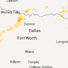
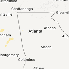

Cities Most Affected by Hail Storms of 4/20/2011
| Hail Size | Demographics of Zip Codes Affected | ||||||
|---|---|---|---|---|---|---|---|
| City | Count | Average | Largest | Pop Density | House Value | Income | Age |
| Idabel, OK | 4 | 2.69 | 4.25 | 58 | $48k | $22.9k | 37.9 |
| Starkville, MS | 5 | 1.95 | 2.75 | 135 | $93k | $25.2k | 25.8 |
| Duck Hill, MS | 3 | 2.25 | 2.50 | 13 | $57k | $27.1k | 42.5 |
| Paint Rock, TX | 3 | 2.08 | 2.75 | 1 | $58k | $34.1k | 48.5 |
| Columbus, MS | 3 | 1.75 | 1.75 | 77 | $60k | $24.0k | 33.9 |
| Oxford, MS | 3 | 1.75 | 1.75 | 105 | $109k | $27.8k | 29.2 |
| Moriarty, NM | 2 | 2.38 | 2.75 | 11 | $91k | $30.3k | 39.2 |
| Junction, TX | 1 | 4.50 | 4.50 | 3 | $51k | $29.8k | 47.4 |
| Brackettville, TX | 2 | 1.88 | 2.00 | 0 | $46k | $28.2k | 45.3 |
| Baird, TX | 1 | 2.50 | 2.50 | 7 | $41k | $30.3k | 46.4 |
| Roosevelt, TX | 1 | 2.25 | 2.25 | 1 | $25k | $30.6k | 50.0 |
| Eldorado, TX | 1 | 1.75 | 1.75 | 1 | $45k | $29.5k | 33.5 |
| Ozona, TX | 1 | 1.75 | 1.75 | 0 | $52k | $29.9k | 39.5 |
| Ballinger, TX | 1 | 1.75 | 1.75 | 15 | $42k | $26.9k | 42.5 |
| Lone Grove, OK | 1 | 1.75 | 1.75 | 39 | $58k | $31.3k | 35.7 |
| Hohenwald, TN | 1 | 1.75 | 1.75 | 53 | $67k | $30.0k | 41.0 |
| Ridgeland, MS | 1 | 1.75 | 1.75 | 847 | $118k | $42.9k | 33.9 |
| University, MS | 1 | 1.75 | 1.75 | 0 | $0k | $30.5k | 19.7 |
| Walthall, MS | 1 | 1.75 | 1.75 | 214 | $33k | $17.5k | 36.8 |
| Crawford, MS | 1 | 1.75 | 1.75 | 19 | $44k | $20.1k | 35.5 |
| Mineral Springs, AR | 1 | 1.75 | 1.75 | 16 | $46k | $28.9k | 39.5 |
| Ozan, AR | 1 | 1.75 | 1.75 | 10 | $39k | $25.2k | 42.3 |
| Anthony, FL | 1 | 1.75 | 1.75 | 116 | $93k | $38.6k | 44.5 |
| Eupora, MS | 1 | 1.75 | 1.75 | 26 | $59k | $26.9k | 41.1 |
| Greenwood, MS | 1 | 1.75 | 1.75 | 128 | $61k | $21.9k | 34.9 |
| Holcomb, MS | 1 | 1.75 | 1.75 | 13 | $56k | $29.8k | 39.3 |
| Kilmichael, MS | 1 | 1.75 | 1.75 | 12 | $42k | $21.8k | 44.3 |
| Mathiston, MS | 1 | 1.75 | 1.75 | 35 | $56k | $27.8k | 38.8 |
| Mc Carley, MS | 1 | 1.75 | 1.75 | 25 | $68k | $30.0k | 41.8 |
Hail and Wind Damage Spotted on 4/20/2011
Filter by Report Type:Hail ReportsWind Reports
States Impacted
Mississippi, Georgia, Alabama, Arkansas, Florida, Oklahoma, Texas, New Mexico, Tennessee, UtahMississippi
| Local Time | Report Details |
|---|---|
| 12:04 PM UTC | Quarter sized hail reported near Starkville, MS, 2.8 miles SW of Starkville, MS |
| 3:42 PM UTC | Golf Ball sized hail reported near Oxford, MS, 58.4 miles SSE of Memphis, TN, golf ball size hail reported by a storm spotter near college hill...relayed by emergency manager. |
| 3:54 PM UTC | Half Dollar sized hail reported near Taylor, MS, 67.1 miles SSE of Memphis, TN, hail slightly larger than quarter size was reported by a storm spotter near the town of taylor. |
| 4:07 PM UTC | Quarter sized hail reported near Water Valley, MS, 63.7 miles NW of Starkville, MS |
| 4:29 PM UTC | Half Dollar sized hail reported near Oxford, MS, 59.3 miles NNW of Starkville, MS |
| 4:58 PM UTC | Quarter sized hail reported near Randolph, MS, 53.3 miles NNW of Starkville, MS |
| 5:22 PM UTC | Ping Pong Ball sized hail reported near Pontotoc, MS, 46.9 miles NNW of Starkville, MS, ping pong ball size hail in the town of wallfield. |
| 5:29 PM UTC | Some trees were blown down on open pasture in tow in webster county MS, 22.9 miles WNW of Starkville, MS |
| 6:00 PM UTC | Quarter sized hail reported near Greenwood, MS, 81.6 miles W of Starkville, MS |
| 6:40 PM UTC | Golf Ball sized hail reported near Greenwood, MS, 67.1 miles WNW of Starkville, MS |
| 6:45 PM UTC | Golf Ball sized hail reported near Holcomb, MS, 65 miles WNW of Starkville, MS |
| 6:55 PM UTC | Golf Ball sized hail reported near McCarley, MS, 63.2 miles W of Starkville, MS |
| 7:00 PM UTC | Ping Pong Ball sized hail reported near Verona, MS, 50.2 miles N of Starkville, MS |
| 7:05 PM UTC | Quarter sized hail reported near Duck Hill, MS, 56 miles WNW of Starkville, MS |
| 7:05 PM UTC | Quarter sized hail reported near Verona, MS, 50.2 miles N of Starkville, MS, quarter size hail reported at the intersection of hwy 45 and main street in verona. |
| 7:15 PM UTC | Golf Ball sized hail reported near Duck Hill, MS, 53 miles WNW of Starkville, MS |
| 7:20 PM UTC | Quarter sized hail reported near Duck Hill, MS, 49.1 miles WNW of Starkville, MS, quarter size hail covering the ground |
| 7:20 PM UTC | Ping Pong Ball sized hail reported near Duck Hill, MS, 47.2 miles WNW of Starkville, MS, reported in the red hill area |
| 8:00 PM UTC | Golf Ball sized hail reported near Eupora, MS, 37.2 miles WNW of Starkville, MS, multiple reports of golf ball size hail over western webster county |
| 8:15 PM UTC | Golf Ball sized hail reported near Walthall, MS, 28.7 miles WNW of Starkville, MS |
| 8:40 PM UTC | Quarter sized hail reported near Eupora, MS, 27.4 miles W of Starkville, MS, sizes ranging from dime to quarter |
| 8:48 PM UTC | Golf Ball sized hail reported near Mathiston, MS, 20.3 miles W of Starkville, MS |
| 9:30 PM UTC | Baseball sized hail reported near Starkville, MS, 9.9 miles WSW of Starkville, MS, sizes ranging from golfball to baseball |
| 9:40 PM UTC | Golf Ball sized hail reported near Starkville, MS, 6.8 miles W of Starkville, MS |
| 9:55 PM UTC | Quarter sized hail reported near Corinth, MS, 48.9 miles WNW of Florence, AL, quarter and nickel sized hail covering ground at home located at 3226 kendrick rd corinth. |
| 9:55 PM UTC | Half Dollar sized hail reported near Blue Springs, MS, 70.3 miles WSW of Florence, AL, quarter to half dollar sized hail covering steps of mobile home on hwy 348 |
| 9:58 PM UTC | Golf Ball sized hail reported near Starkville, MS, 0.6 miles SW of Starkville, MS, sizes ranging from half inch to golf ball |
| 10:20 PM UTC | Golf Ball sized hail reported near Starkville, MS, 1.4 miles ESE of Starkville, MS, quarter to golf ball size hail |
| 5:35 PM CDT | Golf Ball sized hail reported near Starkville, MS, 3.7 miles E of Starkville, MS, reported in the highland plantation area |
| 10:39 PM UTC | Quarter sized hail reported near Carrollton, MS, 70.3 miles W of Starkville, MS |
| 10:40 PM UTC | Winds estimated at 60 mph in blue spring in union county MS, 64.5 miles N of Starkville, MS |
| 10:53 PM UTC | Half Dollar sized hail reported near Carrollton, MS, 64 miles W of Starkville, MS |
| 11:15 PM UTC | Multiple trees downed between carrollton and winon in carroll county MS, 61.1 miles W of Starkville, MS |
| 11:15 PM UTC | Trees down north of batesvill in panola county MS, 53.4 miles S of Memphis, TN |
| 11:25 PM UTC | Quarter sized hail reported near Duck Hill, MS, 56 miles WNW of Starkville, MS |
| 11:35 PM UTC | Tennis Ball sized hail reported near Duck Hill, MS, 51.6 miles WNW of Starkville, MS, half dollar to tennis ball hail near duck hill. |
| 11:48 PM UTC | Golf Ball sized hail reported near University, MS, 61.7 miles SSE of Memphis, TN, golf ball hail 1 mile west of city limits of oxford |
| 11:50 PM UTC | Quarter sized hail reported near Oxford, MS, 61.9 miles SSE of Memphis, TN, quarter hail on campus of university of mississippi |
| 11:51 PM UTC | Golf Ball sized hail reported near Oxford, MS, 61.9 miles SSE of Memphis, TN, golf ball hail in downtown oxford around jackson street. |
| 11:55 PM UTC | Quarter sized hail reported near Vaiden, MS, 55 miles W of Starkville, MS |
| 11:59 PM UTC | Quarter sized hail reported near Holcomb, MS, 69.2 miles WNW of Starkville, MS |
| 12:00 AM UTC | Golf Ball sized hail reported near Oxford, MS, 63 miles SSE of Memphis, TN, golf ball hail on hwy 30 |
| 12:00 AM UTC | Tennis Ball sized hail reported near Duck Hill, MS, 45.7 miles WNW of Starkville, MS |
| 12:02 AM UTC | Quarter sized hail reported near Holcomb, MS, 70.1 miles WNW of Starkville, MS |
| 12:03 AM UTC | A tree fell on a gas meter behind the sumner post office creating a gas lea in tallahatchie county MS, 83.4 miles SSW of Memphis, TN |
| 12:05 AM UTC | Quarter sized hail reported near Grenada, MS, 65.3 miles WNW of Starkville, MS, reported along gillon rd |
| 12:10 AM UTC | Tree down on top of a mobile home in carroll county MS, 64.2 miles W of Starkville, MS |
| 12:22 AM UTC | Tree knocked down on to a mobile home in grenada county MS, 61.6 miles WNW of Starkville, MS |
| 12:35 AM UTC | Power poles snapped...trees downed...and a porch blown off a house in grenada county MS, 61.4 miles WNW of Starkville, MS |
| 12:35 AM UTC | Golf Ball sized hail reported near Kilmichael, MS, 43.8 miles W of Starkville, MS |
| 12:35 AM UTC | Golf Ball sized hail reported near Crawford, MS, 17.7 miles SE of Starkville, MS, reported along tarlton rd |
| 12:38 AM UTC | Several trees down north of seven pines communit in carroll county MS, 74.6 miles W of Starkville, MS |
| 12:40 AM UTC | Several trees down across roads in the duck hill are in montgomery county MS, 53 miles WNW of Starkville, MS |
| 12:40 AM UTC | Several trees and power lines downed across the city of grenada...and in grenada county east of the cit in grenada county MS, 58.7 miles WNW of Starkville, MS |
| 12:50 AM UTC | A tree was downed along 20th st in lowndes county MS, 24 miles E of Starkville, MS |
| 12:55 AM UTC | Tree down on a car and a home. also...tree down blocking highway 12 north of sturgis in oktibbeha county MS, 16.2 miles WSW of Starkville, MS |
| 12:58 AM UTC | Several trees down in city in calhoun county MS, 39.5 miles NW of Starkville, MS |
| 1:00 AM UTC | *** 1 inj *** trees down county wide. one tree fell on a home in houston resulting in injuries to a child. the child was treated for cuts and briuses and release in chickasaw county MS, 31.8 miles NNW of Starkville, MS |
| 1:08 AM UTC | Several trees down across roads in the stewart communit in choctaw county MS, 33.4 miles W of Starkville, MS |
| 1:10 AM UTC | Trees and power lines down...homes damaged. a tree was uprooted on highway 8 which pulled up a gas lin in calhoun county MS, 35.5 miles NW of Starkville, MS |
| 1:10 AM UTC | A couple trees were downed along cr 3122 in attala county MS, 48.8 miles WSW of Starkville, MS |
| 1:15 AM UTC | Estimated winds of 60 mph blowing through town of shannon in lee county MS, 45 miles N of Starkville, MS |
| 1:25 AM UTC | Trees down across the county. one fell on a house in webster county MS, 27.4 miles W of Starkville, MS |
| 1:30 AM UTC | Several trees down in town in chickasaw county MS, 31.8 miles NNW of Starkville, MS |
| 1:30 AM UTC | Trees down across the southern end of lee count in lee county MS, 45 miles N of Starkville, MS |
| 1:35 AM UTC | Golf Ball sized hail reported near Columbus, MS, 24 miles E of Starkville, MS, reported along alabama st...also penny size hail falling on nashville ferry rd. |
| 1:42 AM UTC | Golf Ball sized hail reported near Columbus, MS, 24 miles E of Starkville, MS, reported at the county eoc |
| 1:45 AM UTC | Trees down in the northwest and west-central part of the county. location approximat in oktibbeha county MS, 8.3 miles WNW of Starkville, MS |
| 1:48 AM UTC | Golf Ball sized hail reported near Columbus, MS, 24 miles E of Starkville, MS |
| 1:50 AM UTC | Trees down on southeast side of starkville in oktibbeha county MS, 1.9 miles SSE of Starkville, MS |
| 1:50 AM UTC | Tree down on house on cedar bluff loop in clay county MS, 8.6 miles N of Starkville, MS |
| 1:52 AM UTC | Trees down on hwy 12 west of kosciusk in attala county MS, 54.5 miles WSW of Starkville, MS |
| 1:52 AM UTC | Tree down across northwood forrest road in clay county MS, 16.7 miles NE of Starkville, MS |
| 1:57 AM UTC | Trees down on valentine road...highway 46 and 50 and old white road. the door was blown off a business building in clay county MS, 14.1 miles NE of Starkville, MS |
| 1:57 AM UTC | Trees down...some on power lines in clay county MS, 14.1 miles NE of Starkville, MS |
| 2:00 AM UTC | Trees down county wid in monroe county MS, 44.4 miles NNE of Starkville, MS |
| 2:00 AM UTC | Several trees down over northern monroe count in monroe county MS, 47.9 miles NNE of Starkville, MS |
| 2:06 AM UTC | Tree down on a house on old crawford road in oktibbeha county MS, 8.5 miles SE of Starkville, MS |
| 2:10 AM UTC | Power line down in front of caledonia high school on wolfe road in lowndes county MS, 31.5 miles ENE of Starkville, MS |
| 2:10 AM UTC | Tree down on school road in lowndes county MS, 16 miles SE of Starkville, MS |
| 2:10 AM UTC | Tree down across northwood forrest road in clay county MS, 16.7 miles NE of Starkville, MS |
| 2:10 AM UTC | Quarter sized hail reported near Amory, MS, 40.9 miles NNE of Starkville, MS |
| 2:13 AM UTC | Quarter sized hail reported near Amory, MS, 40.9 miles NNE of Starkville, MS, quarter sized hail in amory |
| 2:15 AM UTC | Three trees knocked down in noxubee county MS, 21.1 miles SE of Starkville, MS |
| 2:30 AM UTC | Half Dollar sized hail reported near Macon, MS, 23.9 miles S of Starkville, MS |
| 2:34 AM UTC | 3 to 4 trees down in town of brooksvill in noxubee county MS, 21.1 miles SE of Starkville, MS |
| 2:43 AM UTC | Couple of trees down in macon in noxubee county MS, 28.6 miles SSE of Starkville, MS |
| 3:04 AM UTC | Ping Pong Ball sized hail reported near Ridgeland, MS, 8.9 miles NNE of Jackson, MS, ping pong ball size hail just west of interstate 55 in ridgeland |
| 3:10 AM UTC | Golf Ball sized hail reported near Ridgeland, MS, 8.9 miles NNE of Jackson, MS, reported at highland colony parkway...old canton road and highway 51 |
| 5:04 AM UTC | Quarter sized hail reported near Forest, MS, 41.6 miles E of Jackson, MS |
Georgia
| Local Time | Report Details |
|---|---|
| 12:22 PM UTC | Gilmer county 911 relayed a report of a tree down in ellija in gilmer county GA, 53.1 miles ESE of Chattanooga, TN |
| 1:25 AM UTC | Large branches and top of pine blown down off germany road in camp dixi in rabun county GA, 47.8 miles W of Greenville, SC |
| 1:25 AM UTC | Tree blown down at heavens landing airpark subdivisio in rabun county GA, 47.3 miles W of Greenville, SC |
| 6:20 AM UTC | The 911 center reported numerous trees and powerlines down countywid in floyd county GA, 54.7 miles S of Chattanooga, TN |
| 6:39 AM UTC | One tree down on village driv in bartow county GA, 41.3 miles NW of Atlanta, GA |
| 6:53 AM UTC | A few trees down on pat mell road. tree fell on ca in cobb county GA, 14.3 miles NW of Atlanta, GA |
| 7:20 AM UTC | Dispatch center reported 5 trees and 5 powerlines down throughout the count in dekalb county GA, 5.2 miles E of Atlanta, GA |
Alabama
| Local Time | Report Details |
|---|---|
| 2:01 PM UTC | 65 mph wind recorded atop the courthouse in downtown tuscaloos in tuscaloosa county AL, 46.3 miles WSW of Birmingham, AL |
| 2:05 PM UTC | Numerous homes damaged in the area of green grove driv in tuscaloosa county AL, 46.3 miles WSW of Birmingham, AL |
| 2:05 PM UTC | Trees down on u/a campus...power out at rose tower in tuscaloosa county AL, 46.3 miles WSW of Birmingham, AL |
| 2:07 PM UTC | 74 mph gust recorded atop the courthouse in down town tuscaloos in tuscaloosa county AL, 46.3 miles WSW of Birmingham, AL |
| 2:08 PM UTC | Large tree down blocking lurleen wallace blvd sout in tuscaloosa county AL, 46.3 miles WSW of Birmingham, AL |
| 2:10 PM UTC | Numerous trees down in the city of tuscaloos in tuscaloosa county AL, 46.3 miles WSW of Birmingham, AL |
| 2:15 PM UTC | Trees down at the entrance of summerville neighborhoo in tuscaloosa county AL, 46.3 miles WSW of Birmingham, AL |
| 2:25 PM UTC | Numerous trees and powerlines down near alabama highway 216 and kingsmill roa in tuscaloosa county AL, 34.8 miles WSW of Birmingham, AL |
| 2:25 PM UTC | Trees and powerlines down near us highway 11 and buttermilk roa in tuscaloosa county AL, 43.4 miles WSW of Birmingham, AL |
| 2:40 PM UTC | Trees and powerlines down on 23rd terrace n in jefferson county AL, 11.2 miles NE of Birmingham, AL |
| 2:40 PM UTC | Roofs damaged at stone gate trailer park on lower coaling roa in tuscaloosa county AL, 39.4 miles SW of Birmingham, AL |
| 2:40 PM UTC | Trees down at us highway 11 at lower coaling road and on dudley road near enterprise churc in tuscaloosa county AL, 39.4 miles SW of Birmingham, AL |
| 3:10 PM UTC | Quarter sized hail reported near Helena, AL, 16 miles S of Birmingham, AL |
| 3:15 PM UTC | Trees and powerlines down in and around double spring in winston county AL, 47.5 miles SSE of Florence, AL |
| 3:57 PM UTC | Tree down near bb comer high school in sylacauga. fire department was dispatched to remove the tre in talladega county AL, 39.6 miles SE of Birmingham, AL |
| 3:58 PM UTC | Quarter sized hail reported near Helena, AL, 16 miles S of Birmingham, AL |
| 8:10 PM UTC | Quarter sized hail reported near Helena, AL, 16 miles S of Birmingham, AL |
| 1:25 AM UTC | Quarter sized hail reported near Sulligent, AL, 49 miles NE of Starkville, MS |
| 1:44 AM UTC | Quarter sized hail reported near Sulligent, AL, 49 miles NE of Starkville, MS |
| 2:15 AM UTC | Trees dow in lamar county AL, 58.7 miles SSW of Florence, AL |
| 2:25 AM UTC | Tree limbs were knocked down which caused a power outage in spring valley. time estimated by rada in colbert county AL, 10.2 miles SSE of Florence, AL |
| 2:26 AM UTC | Trees down across count in lamar county AL, 45.3 miles ENE of Starkville, MS |
| 2:30 AM UTC | At least seven reports of trees down due to thunderstorm winds. the reports were across the eastern half of franklin county between 930 pm and 1000 p in franklin county AL, 24.2 miles SSW of Florence, AL |
| 2:37 AM UTC | A large tree has fallen on a car along highway 278 in beaverton. the occupants of the vehicle were rescued without injurie in lamar county AL, 55.8 miles NE of Starkville, MS |
| 2:37 AM UTC | A large tree has fallen on a car along highway 278 in beaverton. there are unknown injuries at this tim in lamar county AL, 55.8 miles NE of Starkville, MS |
| 2:53 AM UTC | Tree on hous in fayette county AL, 56.8 miles WNW of Birmingham, AL |
| 2:53 AM UTC | Tree and powerline blocking highway 102 near the intersection of co rd 5 in fayette county AL, 56.6 miles WNW of Birmingham, AL |
| 3:12 AM UTC | Numerous trees down in and around carbon hil in walker county AL, 49 miles WNW of Birmingham, AL |
| 3:13 AM UTC | Numerous trees down across fayette count in fayette county AL, 58.8 miles ENE of Starkville, MS |
| 3:15 AM UTC | Trees and powerlines down in and around double spring in winston county AL, 47.5 miles SSE of Florence, AL |
| 3:15 AM UTC | Trees and powerlines were blown down in the city of pickensville. al-14 became temporarily impassable due to fallen tree in pickens county AL, 35.4 miles ESE of Starkville, MS |
| 3:15 AM UTC | Trees dow in lamar county AL, 58.7 miles SSW of Florence, AL |
| 3:19 AM UTC | Trees and powerlines down in and around black pon in winston county AL, 49.7 miles NW of Birmingham, AL |
| 3:22 AM UTC | Trees down in the communities of curry and thatc in walker county AL, 37.5 miles NW of Birmingham, AL |
| 3:28 AM UTC | Trees and powerlines down in and around arle in winston county AL, 44.9 miles NNW of Birmingham, AL |
| 3:36 AM UTC | Trees and powerlines down in and around cordov in walker county AL, 27.4 miles NW of Birmingham, AL |
| 3:40 AM UTC | A tree was blown down onto rue road. trees were blown down on al-171 at the 22 mile marke in tuscaloosa county AL, 50 miles WSW of Birmingham, AL |
| 3:41 AM UTC | Numerous trees down across southern part of count in fayette county AL, 57.5 miles ENE of Starkville, MS |
| 3:54 AM UTC | Tree blocking hwy 31 just of i65 at exit 28 in blount county AL, 25.6 miles N of Birmingham, AL |
| 4:00 AM UTC | Tree down on alliance road and taylors ferry rd in adamsvill in jefferson county AL, 10.2 miles WNW of Birmingham, AL |
| 4:10 AM UTC | Multiple trees down from cr 223 northeast to cr 703. time estimated from rada in cullman county AL, 45.5 miles N of Birmingham, AL |
| 4:10 AM UTC | Tree down blocking hwy 150 just south of shades crest roa in jefferson county AL, 9.7 miles S of Birmingham, AL |
| 4:10 AM UTC | A tree was knocked onto a home on cr 77 in cullman county AL, 44.3 miles NNE of Birmingham, AL |
| 4:10 AM UTC | Tree down on i65 southbound just before alford ave exi in jefferson county AL, 6.2 miles S of Birmingham, AL |
| 4:10 AM UTC | A tree was knocked onto a home on cr 70 in cullman county AL, 43 miles N of Birmingham, AL |
| 4:11 AM UTC | Trees dow in fayette county AL, 57.5 miles ENE of Starkville, MS |
| 4:11 AM UTC | Trees down on mizauma ave at 27th pl s in jefferson county AL, 2.3 miles SE of Birmingham, AL |
| 4:11 AM UTC | Tree down on cherry s in jefferson county AL, 3.6 miles ESE of Birmingham, AL |
| 4:15 AM UTC | Trees were blown down at willow lake road and hepezba church road...and on woodland lake road...near the lake view communit in tuscaloosa county AL, 26.1 miles SW of Birmingham, AL |
| 5:06 AM UTC | Tree down on the administration building at the city court apt on broadway roa in talladega county AL, 41.6 miles E of Birmingham, AL |
| 5:06 AM UTC | Tree donw in front of stemley school blocking roa in talladega county AL, 38.8 miles E of Birmingham, AL |
| 5:14 AM UTC | A small power outage was reported due to knocked down tree limbs or lightnin in marshall county AL, 58 miles NNE of Birmingham, AL |
| 5:14 AM UTC | Small tree limbs were knocked down on the guntersville peninsula are in marshall county AL, 65.2 miles NNE of Birmingham, AL |
| 5:32 AM UTC | Trees down in gallant in etowah county AL, 46.2 miles NE of Birmingham, AL |
| 5:50 AM UTC | Trees down on county road 61 near cullman lak in cleburne county AL, 67.3 miles W of Atlanta, GA |
Arkansas
| Local Time | Report Details |
|---|---|
| 4:49 PM UTC | Quarter sized hail reported near Boles, AR, 47.3 miles SSE of Fort Smith, AR, reported along hwy 71 south of boles. |
| 5:01 PM UTC | Quarter sized hail reported near Parks, AR, 48.3 miles SSE of Fort Smith, AR |
| 7:08 PM UTC | Quarter sized hail reported near Little Rock, AR, 5.5 miles W of Little Rock, AR, hail fell between napa valley rd and green mountain dr. |
| 7:12 PM UTC | Quarter sized hail reported near Mena, AR, 46.3 miles NNW of Nashville, AR |
| 7:15 PM UTC | Quarter sized hail reported near Greenwood, AR, 17.4 miles SSE of Fort Smith, AR |
| 7:25 PM UTC | Quarter sized hail reported near North Little Rock, AR, 3 miles NNE of Little Rock, AR, hail fell at mccain mall. |
| 7:30 PM UTC | Quarter sized hail reported near North Little Rock, AR, 3 miles NNE of Little Rock, AR, hail fell at nlr nissan on landers rd. |
| 7:35 PM UTC | Quarter sized hail reported near Boles, AR, 45.1 miles SSE of Fort Smith, AR, hail fell at intersection of hwy 71 and 28 east. |
| 7:46 PM UTC | Quarter sized hail reported near Nashville, AR, 3.6 miles SW of Nashville, AR, hwy 27 north between nashville and mineral springs |
| 7:47 PM UTC | Golf Ball sized hail reported near Mineral Springs, AR, 6.3 miles SW of Nashville, AR, volunteer fire dept reported hail busted out his windshield. |
| 8:02 PM UTC | Golf Ball sized hail reported near Ozan, AR, 7.1 miles SSE of Nashville, AR, up to golfball size hail at the intersection of 332 and hwy 278n |
| 8:40 PM UTC | Quarter sized hail reported near Little Rock, AR, 7.8 miles W of Little Rock, AR, hail fell at kirk rd and chenall pkwy. |
| 8:47 PM UTC | Quarter sized hail reported near Little Rock, AR, 10.6 miles WNW of Little Rock, AR, hail fell near taylor loop rd and heatherstone point. |
| 8:47 PM UTC | Quarter sized hail reported near Sulphur Rock, AR, 89.4 miles NNE of Little Rock, AR, hail fell near taylor loop rd and heatherstone point. |
| 8:53 PM UTC | Quarter sized hail reported near De Valls Bluff, AR, 46.7 miles E of Little Rock, AR |
| 10:04 PM UTC | Quarter sized hail reported near Sheridan, AR, 31.2 miles SSW of Little Rock, AR |
| 10:22 PM UTC | Quarter sized hail reported near Pine Bluff, AR, 40.1 miles SSE of Little Rock, AR |
| 10:25 PM UTC | Quarter sized hail reported near West Helena, AR, 54.7 miles SW of Memphis, TN, quarter sized hail in shady acres development 3/4 mile south of west helenea airport |
| 11:25 PM UTC | Quarter sized hail reported near Dierks, AR, 13.9 miles NW of Nashville, AR |
| 11:45 PM UTC | Quarter sized hail reported near Gillham, AR, 30.7 miles WNW of Nashville, AR, quarter size hail fell in gillham. |
| 12:07 AM UTC | Tree down north of hwy 26 and 369 jun in howard county AR, 5.5 miles NNW of Nashville, AR |
| 1:13 AM UTC | Quarter sized hail reported near Atkins, AR, 46.1 miles NW of Little Rock, AR |
| 2:50 AM UTC | Several trees down at farm to market and hwy 32 in sevier county AR, 29 miles WNW of Nashville, AR |
| 5:46 AM UTC | Quarter sized hail reported near Prescott, AR, 28.2 miles ESE of Nashville, AR |
Florida
| Local Time | Report Details |
|---|---|
| 8:00 PM UTC | 911 reported trees down in the waccasassa lake area. time estimated from rada in gilchrist county FL, 79.5 miles SW of Jacksonville, FL |
| 8:10 PM UTC | Quarter sized hail reported near Morriston, FL, 87.4 miles NW of Orlando, FL, quarter sized hail relayed by emergency management. |
| 8:35 PM UTC | Emergency manager reported a tree down at sw 194th st and sr45. time estimated by rada in alachua county FL, 73.6 miles SW of Jacksonville, FL |
| 8:56 PM UTC | Emergency manager reported a tree down at sw 194th st and sr4 in alachua county FL, 73.6 miles SW of Jacksonville, FL |
| 9:05 PM UTC | Quarter sized hail reported near Keystone Heights, FL, 43.5 miles SSW of Jacksonville, FL, quarter size hail reported by spotter at intersection of florida route 100 and route 21 near keystone heights. also reported small limbs down. |
| 9:08 PM UTC | Golf Ball sized hail reported near Anthony, FL, 68.2 miles NW of Orlando, FL, ocala electric employee relayed a report of golf ball sized hail in anthony. |
| 9:15 PM UTC | Ping Pong Ball sized hail reported near Ocala, FL, 66 miles NW of Orlando, FL, ocala electric employee reported ping pong ball sized hail just north of ocala. |
| 9:15 PM UTC | Lawn furniture tossed around yard. 16 foot ladder thrown 12 feet across boat slip. time estimated by rada in putnam county FL, 55.5 miles SSW of Jacksonville, FL |
| 10:00 PM UTC | Large oak tree blown over by thunderstorm winds on central avenue in crescent city. time estimated by rada in putnam county FL, 61.9 miles N of Orlando, FL |
| 10:35 PM UTC | Quarter sized hail reported near Starke, FL, 26.6 miles SW of Jacksonville, FL, nickel to quarter size hail reported by the general public west of middleburg. localized flooding also reported. |
Oklahoma
| Local Time | Report Details |
|---|---|
| 8:44 PM UTC | Quarter sized hail reported near Idabel, OK, 56 miles W of Nashville, AR |
| 8:45 PM UTC | Golf Ball sized hail reported near Idabel, OK, 54.9 miles W of Nashville, AR |
| 8:55 PM UTC | Hen Egg sized hail reported near Idabel, OK, 56 miles W of Nashville, AR |
| 8:57 PM UTC | Baseball sized hail reported near Idabel, OK, 56 miles W of Nashville, AR, baseball sized hail at newspaper office in idabell |
| 9:00 PM UTC | Grapefruit sized hail reported near Idabel, OK, 56 miles W of Nashville, AR, reported by sheriffs office |
| 9:57 PM UTC | Quarter sized hail reported near Watson, OK, 50.3 miles WNW of Nashville, AR, quarter size hail falling at the beavers bend state park office near broken bow lake. |
| 10:40 PM UTC | Quarter sized hail reported near Watson, OK, 50.3 miles WNW of Nashville, AR, quarter size hail fell from the 2nd severe thunderstorm that tracked across beavers bend state park near broken bow lake. |
| 4:04 AM UTC | Golf Ball sized hail reported near Lone Grove, OK, 66.5 miles WSW of Atoka, OK |
Texas
| Local Time | Report Details |
|---|---|
| 9:04 PM UTC | Quarter sized hail reported near Menard, TX, 97.8 miles S of Abilene, TX, quarter size hail reported 8 miles north of menard |
| 9:23 PM UTC | Quarter sized hail reported near Menard, TX, 105.9 miles S of Abilene, TX, quarter size hail along us-190 about 8 miles west of menard |
| 9:40 PM UTC | Golf Ball sized hail reported near Paint Rock, TX, 75.6 miles S of Abilene, TX, golball size hail just southwest of the interesection of us-83 and rr-765. |
| 9:45 PM UTC | Baseball sized hail reported near Paint Rock, TX, 74.8 miles SSW of Abilene, TX, 4 windows shattered...multiple holes in the siding of mobile home...all windows in truck knocked out...roof damage |
| 9:55 PM UTC | Quarter sized hail reported near Christoval, TX, 98.2 miles SSW of Abilene, TX |
| 10:01 PM UTC | Golf Ball sized hail reported near Paint Rock, TX, 65.7 miles S of Abilene, TX, golfball size hail in paint rock. |
| 10:06 PM UTC | Quarter sized hail reported near Junction, TX, 105 miles NE of Del Rio, TX, quarter size hail falling in cleo. still falling as of 516 pm. |
| 10:06 PM UTC | Quarter sized hail reported near London, TX, 107.8 miles NE of Del Rio, TX, quarter size hail falling in cleo. |
| 10:16 PM UTC | Quarter sized hail reported near Junction, TX, 105 miles NE of Del Rio, TX |
| 10:30 PM UTC | Quarter sized hail reported near Rowena, TX, 58 miles SSW of Abilene, TX, quarter size hail in rowena |
| 10:40 PM UTC | Golf Ball sized hail reported near Ballinger, TX, 50.5 miles SSW of Abilene, TX, golfball size hail covering the ground in ballinger. |
| 10:42 PM UTC | Quarter sized hail reported near Junction, TX, 98.2 miles NE of Del Rio, TX, quarter size hail along i-10 west of junction |
| 11:11 PM UTC | Softball sized hail reported near Junction, TX, 99.3 miles NE of Del Rio, TX, softball size hail damaging vehicles along i-10...just west of junction. |
| 11:39 PM UTC | Ping Pong Ball sized hail reported near Novice, TX, 32.4 miles SSE of Abilene, TX, ping pong ball size hail in novice. |
| 11:45 PM UTC | Tennis Ball sized hail reported near Baird, TX, 25.5 miles SE of Abilene, TX, golfball to nearly baseball size hail falling 12 miles south of baird. |
| 11:48 PM UTC | Quarter sized hail reported near Roosevelt, TX, 92.3 miles NNE of Del Rio, TX |
| 12:00 AM UTC | Ping Pong Ball sized hail reported near Roosevelt, TX, 92.3 miles NNE of Del Rio, TX, hail 1.5 inches in diameter. |
| 12:04 AM UTC | Hen Egg sized hail reported near Roosevelt, TX, 92.3 miles NNE of Del Rio, TX, hail measured at billiard ball size |
| 12:10 AM UTC | Quarter sized hail reported near Clyde, TX, 14.5 miles ESE of Abilene, TX |
| 12:15 AM UTC | Quarter sized hail reported near Putnam, TX, 32.7 miles E of Abilene, TX |
| 1:32 AM UTC | Golf Ball sized hail reported near Eldorado, TX, 102.9 miles N of Del Rio, TX, vehicle windows damaged |
| 1:35 AM UTC | Quarter sized hail reported near , , 63.4 miles S of Wichita Falls, TX, quarter size hail in south bend |
| 1:42 AM UTC | Quarter sized hail reported near Iraan, TX, 70.5 miles SSE of Odessa, TX |
| 2:15 AM UTC | Golf Ball sized hail reported near Ozona, TX, 93.5 miles N of Del Rio, TX |
| 2:35 AM UTC | Quarter sized hail reported near Bowie, TX, 46.9 miles SE of Wichita Falls, TX, quarter size hail reported at amon carter lake |
| 2:37 AM UTC | Quarter sized hail reported near Bowie, TX, 44.1 miles ESE of Wichita Falls, TX, quarter size hail covering the ground in bowie |
| 3:00 AM UTC | Quarter sized hail reported near Bowie, TX, 43.8 miles ESE of Wichita Falls, TX, quarter size hail 1 mi n of montague on hwy 59 |
| 3:00 AM UTC | Quarter sized hail reported near Montague, TX, 47.6 miles ESE of Wichita Falls, TX, quarter size hail 1 mi n of montague |
| 3:19 AM UTC | Quarter sized hail reported near Nocona, TX, 46.1 miles E of Wichita Falls, TX, quarter size hail reported at lake nocona |
| 4:15 AM UTC | Quarter sized hail reported near Brackettville, TX, 29.1 miles E of Del Rio, TX, quarter size hail. |
| 4:30 AM UTC | Hen Egg sized hail reported near Brackettville, TX, 29.6 miles E of Del Rio, TX, half dollar to hen egg size hail reported near brackettville. damage to cars and roof shingles. |
| 4:36 AM UTC | Golf Ball sized hail reported near Brackettville, TX, 29.6 miles E of Del Rio, TX, dime to golfball hail in brackettville. |
| 4:50 AM UTC | Quarter sized hail reported near Brackettville, TX, 29.6 miles E of Del Rio, TX, quarter size hail. |
New Mexico
| Local Time | Report Details |
|---|---|
| 9:50 PM UTC | Baseball sized hail reported near Moriarty, NM, 3685.1 miles E of Caribou, ME, larger than baseball size hail falling along rr-765 east of eola. |
| 10:59 PM UTC | Hen Egg sized hail reported near Moriarty, NM, 3723.6 miles E of Caribou, ME, larger than golfball size hail. hail may be larger. several huge dents in roof of car. |
Tennessee
| Local Time | Report Details |
|---|---|
| 10:50 PM UTC | Quarter sized hail reported near Middleton, TN, 66.7 miles E of Memphis, TN, quarter sized hail on peaviner rd between middleton and bolivar . |
| 11:05 PM UTC | Quarter sized hail reported near Waynesboro, TN, 36.1 miles N of Florence, AL, one hail occurred estimated to have occurred between 550 pm and 605 pm. |
| 11:18 PM UTC | Golf Ball sized hail reported near Hohenwald, TN, 47 miles N of Florence, AL |
| 11:25 PM UTC | Quarter sized hail reported near Hohenwald, TN, 47.7 miles NNE of Florence, AL, quarter size hail reported on napier road in southeastern lewis county |
| 11:29 PM UTC | Half Dollar sized hail reported near Summertown, TN, 47.4 miles NNE of Florence, AL, 1.25 inch hail reported just west of summertown between 614 pm and 629 pm |
Utah
| Local Time | Report Details |
|---|---|
| 6:10 AM UTC | Upper cedar mountain sensor in tooele county UT, 64.4 miles WSW of Salt Lake City, UT |
| 6:10 AM UTC | Playa station sensor in tooele county UT, 72.8 miles WSW of Salt Lake City, UT |
Connect with Interactive Hail Maps