

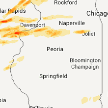
Hail Map for Sunday, April 3, 2011

Number of Impacted Households on 4/3/2011
0
Impacted by 1" or Larger Hail
0
Impacted by 1.75" or Larger Hail
0
Impacted by 2.5" or Larger Hail
Square Miles of Populated Area Impacted on 4/3/2011
0
Impacted by 1" or Larger Hail
0
Impacted by 1.75" or Larger Hail
0
Impacted by 2.5" or Larger Hail


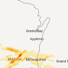


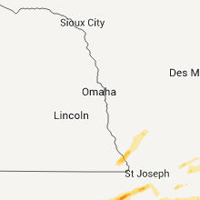
Cities Most Affected by Hail Storms of 4/3/2011
| Hail Size | Demographics of Zip Codes Affected | ||||||
|---|---|---|---|---|---|---|---|
| City | Count | Average | Largest | Pop Density | House Value | Income | Age |
| Dubuque, IA | 7 | 2.14 | 3.00 | 946 | $92k | $38.0k | 38.1 |
| Lees Summit, MO | 6 | 2.13 | 2.50 | 2390 | $114k | $55.4k | 34.3 |
| Middleton, WI | 5 | 2.30 | 2.75 | 797 | $185k | $56.0k | 39.9 |
| Greenwood, MO | 3 | 2.67 | 3.00 | 383 | $124k | $66.0k | 36.5 |
| Madison, WI | 3 | 2.08 | 2.50 | 7050 | $143k | $31.0k | 30.4 |
| Swisher, IA | 3 | 1.83 | 2.00 | 87 | $154k | $70.3k | 42.4 |
| Minooka, IL | 3 | 1.75 | 1.75 | 198 | $175k | $63.2k | 32.7 |
| Lawrence, KS | 2 | 1.88 | 2.00 | 388 | $117k | $36.7k | 27.1 |
| Berryton, KS | 2 | 1.75 | 1.75 | 46 | $116k | $62.2k | 47.5 |
| Emporia, KS | 2 | 1.75 | 1.75 | 99 | $71k | $32.1k | 30.7 |
| Saint Marys, KS | 2 | 1.75 | 1.75 | 62 | $80k | $40.2k | 24.7 |
| Marion, KS | 2 | 1.75 | 1.75 | 16 | $58k | $33.4k | 46.7 |
| Meriden, KS | 2 | 1.75 | 1.75 | 45 | $86k | $47.9k | 43.1 |
| Olathe, KS | 2 | 1.75 | 1.75 | 886 | $124k | $52.8k | 33.4 |
| Verona, WI | 1 | 2.50 | 2.50 | 288 | $182k | $69.7k | 39.3 |
| Lincolnville, KS | 1 | 2.00 | 2.00 | 3 | $33k | $39.7k | 44.1 |
| Carbondale, KS | 1 | 1.75 | 1.75 | 39 | $69k | $37.3k | 42.8 |
| Delia, KS | 1 | 1.75 | 1.75 | 8 | $49k | $37.3k | 32.0 |
| Peru, IL | 1 | 1.75 | 1.75 | 256 | $87k | $38.1k | 44.6 |
| Benton, KS | 1 | 1.75 | 1.75 | 25 | $82k | $50.1k | 39.7 |
| Marshall, AR | 1 | 1.75 | 1.75 | 13 | $48k | $22.0k | 45.8 |
| Amana, IA | 1 | 1.75 | 1.75 | 35 | $132k | $47.5k | 47.6 |
| Cedar Rapids, IA | 1 | 1.75 | 1.75 | 715 | $88k | $39.8k | 32.4 |
| Williamsburg, IA | 1 | 1.75 | 1.75 | 29 | $100k | $40.5k | 40.0 |
| Worthington, IA | 1 | 1.75 | 1.75 | 18 | $80k | $42.5k | 39.5 |
| Channahon, IL | 1 | 1.75 | 1.75 | 524 | $155k | $70.8k | 35.8 |
| Ladd, IL | 1 | 1.75 | 1.75 | 299 | $80k | $41.2k | 38.8 |
| Dyersville, IA | 1 | 1.75 | 1.75 | 92 | $95k | $39.4k | 40.8 |
| Homestead, IA | 1 | 1.75 | 1.75 | 19 | $107k | $50.8k | 41.6 |
| Leighton, IA | 1 | 1.75 | 1.75 | 15 | $83k | $40.6k | 42.4 |
| Muscatine, IA | 1 | 1.75 | 1.75 | 177 | $84k | $41.0k | 38.1 |
| Riverside, IA | 1 | 1.75 | 1.75 | 27 | $101k | $46.5k | 38.6 |
| Overbrook, KS | 1 | 1.75 | 1.75 | 17 | $82k | $46.1k | 45.0 |
| Overland Park, KS | 1 | 1.75 | 1.75 | 3835 | $228k | $87.8k | 37.7 |
| Valley Falls, KS | 1 | 1.75 | 1.75 | 19 | $68k | $39.3k | 42.0 |
| Winfield, KS | 1 | 1.75 | 1.75 | 57 | $63k | $36.6k | 39.0 |
| Jameson, MO | 1 | 1.75 | 1.75 | 5 | $30k | $23.5k | 47.2 |
| Kearney, MO | 1 | 1.75 | 1.75 | 234 | $133k | $63.1k | 38.1 |
| Potosi, WI | 1 | 1.75 | 1.75 | 27 | $80k | $38.5k | 44.0 |
| Shullsburg, WI | 1 | 1.75 | 1.75 | 17 | $67k | $33.9k | 40.8 |
| Liberty, MO | 1 | 1.75 | 1.75 | 410 | $120k | $53.7k | 37.8 |
| Abilene, TX | 1 | 1.75 | 1.75 | 75 | $58k | $26.3k | 30.2 |
| Darlington, WI | 1 | 1.75 | 1.75 | 34 | $71k | $37.1k | 39.3 |
| De Forest, WI | 1 | 1.75 | 1.75 | 256 | $143k | $60.3k | 37.8 |
| Hazel Green, WI | 1 | 1.75 | 1.75 | 47 | $87k | $41.5k | 44.7 |
| Wisconsin Dells, WI | 1 | 1.75 | 1.75 | 65 | $99k | $39.2k | 42.2 |
Hail and Wind Damage Spotted on 4/3/2011
Filter by Report Type:Hail ReportsWind Reports
States Impacted
Wisconsin, Colorado, Iowa, Kansas, Missouri, Pennsylvania, Nebraska, Illinois, Texas, Tennessee, Indiana, Kentucky, Arkansas, West VirginiaWisconsin
| Local Time | Report Details |
|---|---|
| 1:35 PM UTC | Quarter sized hail reported near Sparta, WI, 23.8 miles ENE of La Crosse, WI, dime to quarter size hail |
| 2:20 PM UTC | Quarter sized hail reported near Mauston, WI, 57.2 miles NW of Madison, WI, dime to quarter size hail 5 south of mauston on hwy 58 |
| 2:28 PM UTC | Quarter sized hail reported near Wisconsin Dells, WI, 49.7 miles NNW of Madison, WI, lasted 15 minutes |
| 2:36 PM UTC | Golf Ball sized hail reported near Wisconsin Dells, WI, 43.4 miles NNW of Madison, WI |
| 4:54 PM UTC | Quarter sized hail reported near Franklin, WI, 71.8 miles E of Madison, WI, delayed report relayed by broadcast media. nickel to quarter size hail observed. |
| 12:55 AM UTC | Golf Ball sized hail reported near Potosi, WI, 69.4 miles WSW of Madison, WI |
| 1:05 AM UTC | Quarter sized hail reported near Platteville, WI, 60 miles WSW of Madison, WI |
| 1:05 AM UTC | Quarter sized hail reported near Platteville, WI, 61.9 miles WSW of Madison, WI |
| 1:11 AM UTC | Quarter sized hail reported near Hazel Green, WI, 69.5 miles WSW of Madison, WI, cooperative observer reports one half inch to quarter size hail |
| 1:23 AM UTC | Golf Ball sized hail reported near Hazel Green, WI, 66.6 miles NE of Cedar Rapids, IA |
| 8:55 PM CDT | Golf Ball sized hail reported near Darlington, WI, 46.1 miles SW of Madison, WI, golf ball size hail reported by lafayette county sheriff deputy northwest of darlington and east of belmont. |
| 2:20 AM UTC | Golf Ball sized hail reported near Springdale, WI, 16.9 miles WSW of Madison, WI, spotter reported hearing glass break nearby. extent of damage currently unknown. |
| 2:23 AM UTC | Half Dollar sized hail reported near Mt Horeb, WI, 17.9 miles WSW of Madison, WI |
| 2:25 AM UTC | Ping Pong Ball sized hail reported near Mt Horeb, WI, 17.9 miles WSW of Madison, WI |
| 9:30 PM CDT | Hen Egg sized hail reported near Middleton, WI, 6.5 miles WNW of Madison, WI |
| 9:33 PM CDT | Golf Ball sized hail reported near Middleton, WI, 7.2 miles WNW of Madison, WI |
| 9:33 PM CDT | Tennis Ball sized hail reported near Madison, WI, 1.5 miles NE of Madison, WI |
| 9:35 PM CDT | Baseball sized hail reported near Middleton, WI, 6.5 miles WNW of Madison, WI |
| 9:36 PM CDT | Tennis Ball sized hail reported near Middleton, WI, 7.2 miles WNW of Madison, WI, delayed report. still large amounts of hail on the ground...and one stone still 2.25 inches across after melting as of 1152 pm cdt. |
| 9:36 PM CDT | Tennis Ball sized hail reported near Verona, WI, 10.3 miles W of Madison, WI, measured 2.25. |
| 9:38 PM CDT | Ping Pong Ball sized hail reported near Madison, WI, 0.6 miles NE of Madison, WI, observed at ulbrich botanical gardens. viewer report relayed by wmtv-tv. |
| 9:39 PM CDT | Ping Pong Ball sized hail reported near Middleton, WI, 5.8 miles WNW of Madison, WI |
| 9:39 PM CDT | Hen Egg sized hail reported near Madison, WI, 2.4 miles ENE of Madison, WI |
| 9:42 PM CDT | Quarter sized hail reported near Middleton, WI, 6.6 miles WNW of Madison, WI |
| 9:45 PM CDT | Golf Ball sized hail reported near Madison, WI, 0.6 miles NE of Madison, WI |
| 9:50 PM CDT | Golf Ball sized hail reported near Shullsburg, WI, 55.1 miles SW of Madison, WI |
| 9:51 PM CDT | Tennis Ball sized hail reported near Middleton, WI, 6.5 miles WNW of Madison, WI, raquetball size hail. |
| 9:55 PM CDT | Golf Ball sized hail reported near Deforest, WI, 12.4 miles N of Madison, WI, sizeable amount of golfball size hail. |
| 10:15 PM CDT | Quarter sized hail reported near Fall River, WI, 27.7 miles NE of Madison, WI |
| 3:30 AM UTC | Quarter sized hail reported near Beaver Dam, WI, 37 miles NE of Madison, WI |
| 10:31 PM CDT | Quarter sized hail reported near Oregon, WI, 10.9 miles SSW of Madison, WI |
| 10:35 PM CDT | Quarter sized hail reported near Oregon, WI, 9.9 miles S of Madison, WI |
| 4:02 AM UTC | Quarter sized hail reported near Watertown, WI, 35 miles ENE of Madison, WI |
| 4:04 AM UTC | Quarter sized hail reported near Watertown, WI, 34.2 miles ENE of Madison, WI |
| 1:15 AM CDT | A corn crib was blown down near the intersection of sth 33 and cth p in east-central dodge county. time is estimated based on radar imagery. delayed repor in dodge county WI, 52.3 miles ENE of Madison, WI |
| 1:33 AM CDT | Delayed report. branches down...roof shingles blown off...scattered debri in washington county WI, 65.4 miles ENE of Madison, WI |
Colorado
| Local Time | Report Details |
|---|---|
| 3:30 PM UTC | Rifle airport asos reported 75mph wind gust in garfield county CO, 56.1 miles NE of Grand Junction, CO |
Iowa
| Local Time | Report Details |
|---|---|
| 11:07 PM UTC | Golf Ball sized hail reported near Leighton, IA, 45.9 miles ESE of Des Moines, IA, report from kcci viewer. time estimated |
| 11:11 PM UTC | Quarter sized hail reported near New Sharon, IA, 50.9 miles E of Des Moines, IA |
| 11:17 PM UTC | Quarter sized hail reported near Marengo, IA, 24.5 miles WSW of Cedar Rapids, IA |
| 11:25 PM UTC | Quarter sized hail reported near Montezuma, IA, 52 miles WSW of Cedar Rapids, IA, report from kcci viewer. time estimated |
| 11:25 PM UTC | Golf Ball sized hail reported near Homestead, IA, 17.5 miles SW of Cedar Rapids, IA, time estimated by radar. |
| 11:29 PM UTC | Golf Ball sized hail reported near Williamsburg, IA, 33.6 miles SW of Cedar Rapids, IA, near mile marker 210/211 on interstate 80. |
| 11:32 PM UTC | Golf Ball sized hail reported near Amana, IA, 16.9 miles SW of Cedar Rapids, IA |
| 11:34 PM UTC | Quarter sized hail reported near Marengo, IA, 30.5 miles WSW of Cedar Rapids, IA |
| 11:34 PM UTC | Quarter sized hail reported near Atkins, IA, 9.6 miles W of Cedar Rapids, IA |
| 11:40 PM UTC | Golf Ball sized hail reported near Swisher, IA, 9.5 miles S of Cedar Rapids, IA, delayed report. |
| 6:44 PM CDT | Golf Ball sized hail reported near Cedar Rapids, IA, 0.5 miles SSE of Cedar Rapids, IA, just south of cedar rapids airport. |
| 11:45 PM UTC | Quarter sized hail reported near Hiawatha, IA, 5.1 miles N of Cedar Rapids, IA |
| 11:45 PM UTC | Delayed repor in johnson county IA, 15.3 miles SSE of Cedar Rapids, IA |
| 11:47 PM UTC | Quarter sized hail reported near South English, IA, 42.2 miles SW of Cedar Rapids, IA, time estimated from radar. |
| 11:47 PM UTC | Golf Ball sized hail reported near Swisher, IA, 9.4 miles S of Cedar Rapids, IA |
| 11:50 PM UTC | Quarter sized hail reported near Amana, IA, 15.8 miles SW of Cedar Rapids, IA |
| 11:51 PM UTC | Hen Egg sized hail reported near Swisher, IA, 10.3 miles S of Cedar Rapids, IA |
| 11:57 PM UTC | Quarter sized hail reported near Central City, IA, 13.2 miles NNE of Cedar Rapids, IA |
| 12:05 AM UTC | Half Dollar sized hail reported near Prairieburg, IA, 22.1 miles NE of Cedar Rapids, IA |
| 12:14 AM UTC | Quarter sized hail reported near Hopkinton, IA, 32.6 miles NE of Cedar Rapids, IA |
| 12:17 AM UTC | Quarter sized hail reported near Hopkinton, IA, 33.2 miles NE of Cedar Rapids, IA |
| 12:22 AM UTC | Golf Ball sized hail reported near Dyersville, IA, 45.4 miles NE of Cedar Rapids, IA, quarter size to golf ball size hail being reported...time estimated by radar. |
| 12:22 AM UTC | Golf Ball sized hail reported near Worthington, IA, 41.3 miles NE of Cedar Rapids, IA, quarter size to golf ball size hail being reported...time estimated by radar. |
| 12:28 AM UTC | Quarter sized hail reported near Dyersville, IA, 45 miles NE of Cedar Rapids, IA |
| 12:34 AM UTC | Quarter sized hail reported near Epworth, IA, 51.9 miles NE of Cedar Rapids, IA |
| 12:40 AM UTC | Quarter sized hail reported near Epworth, IA, 52.7 miles NE of Cedar Rapids, IA |
| 12:49 AM UTC | Golf Ball sized hail reported near Riverside, IA, 35.6 miles S of Cedar Rapids, IA |
| 12:50 AM UTC | Ping Pong Ball sized hail reported near Lowden, IA, 39.7 miles ESE of Cedar Rapids, IA |
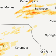
| 1:16 AM UTC | Golf Ball sized hail reported near Dubuque, IA, 58 miles NE of Cedar Rapids, IA, occurring in swiss valley right now. |
| 1:18 AM UTC | Quarter sized hail reported near Muscatine, IA, 50.4 miles SE of Cedar Rapids, IA |
| 1:19 AM UTC | Golf Ball sized hail reported near Dubuque, IA, 62.1 miles NE of Cedar Rapids, IA, south side of dubuque |
| 1:21 AM UTC | Quarter sized hail reported near Dubuque, IA, 60 miles NE of Cedar Rapids, IA |
| 1:21 AM UTC | Golf Ball sized hail reported near Dubuque, IA, 61.7 miles NE of Cedar Rapids, IA, quarter to golf ball size hail falling. |
| 1:21 AM UTC | Golf Ball sized hail reported near Muscatine, IA, 47.3 miles SE of Cedar Rapids, IA |
| 8:21 PM CDT | Hen Egg sized hail reported near Dubuque, IA, 63.3 miles NE of Cedar Rapids, IA, 1 to 2 inch hail |
| 1:22 AM UTC | Half Dollar sized hail reported near Muscatine, IA, 49.5 miles SE of Cedar Rapids, IA |
| 1:23 AM UTC | Golf Ball sized hail reported near Dubuque, IA, 62.1 miles NE of Cedar Rapids, IA, occurring right now at clark university. |
| 1:24 AM UTC | Quarter sized hail reported near Dubuque, IA, 62.9 miles NE of Cedar Rapids, IA, occurring right now. |
| 1:27 AM UTC | Quarter sized hail reported near Muscatine, IA, 50 miles SE of Cedar Rapids, IA |
| 1:27 AM UTC | Ping Pong Ball sized hail reported near Muscatine, IA, 50.3 miles SE of Cedar Rapids, IA |
| 1:29 AM UTC | Tea Cup sized hail reported near Dubuque, IA, 62.9 miles NE of Cedar Rapids, IA |
| 8:30 PM CDT | Tea Cup sized hail reported near Dubuque, IA, 63.3 miles NE of Cedar Rapids, IA, 3 to 3.5 inch hail. streets filed with hail. |
| 1:31 AM UTC | Quarter sized hail reported near Grandview, IA, 54.2 miles SSE of Cedar Rapids, IA |
| 1:33 AM UTC | Quarter sized hail reported near College Springs, IA, 66.5 miles SE of Omaha, NE |
| 1:40 AM UTC | Quarter sized hail reported near Blanchard, IA, 62.4 miles SE of Omaha, NE, 5 minutes of hail 2 ssw west of college sp |
| 1:40 AM UTC | Quarter sized hail reported near Braddyville, IA, 69.9 miles SE of Omaha, NE, 5 minutes of hail 7 southeast of sham |
| 1:45 AM UTC | Ping Pong Ball sized hail reported near Gravity, IA, 71.6 miles ESE of Omaha, NE |
| 1:48 AM UTC | Half Dollar sized hail reported near Bedford, IA, 70.3 miles ESE of Omaha, NE |
| 2:29 AM UTC | Quarter sized hail reported near Keokuk, IA, 14.8 miles ENE of Kahoka, MO |
Kansas
| Local Time | Report Details |
|---|---|
| 11:15 PM UTC | Quarter sized hail reported near Wamego, KS, 9.5 miles ENE of Manhattan, KS |
| 11:20 PM UTC | Quarter sized hail reported near St George, KS, 7.7 miles E of Manhattan, KS, hail nickel to quarter size. |
| 11:23 PM UTC | Quarter sized hail reported near Wamego, KS, 13.1 miles E of Manhattan, KS |
| 11:23 PM UTC | Quarter sized hail reported near Manhattan, KS, 10.4 miles ESE of Manhattan, KS |
| 11:42 PM UTC | Half Dollar sized hail reported near St Marys, KS, 27 miles E of Manhattan, KS |
| 11:42 PM UTC | Half Dollar sized hail reported near Maple Hill, KS, 22.1 miles E of Manhattan, KS |
| 11:43 PM UTC | Golf Ball sized hail reported near St Marys, KS, 25.9 miles E of Manhattan, KS |
| 11:45 PM UTC | Quarter sized hail reported near Rossville, KS, 29.8 miles E of Manhattan, KS |
| 11:45 PM UTC | Golf Ball sized hail reported near St Marys, KS, 26.4 miles E of Manhattan, KS |
| 11:49 PM UTC | Quarter sized hail reported near Delia, KS, 32.6 miles E of Manhattan, KS |
| 11:50 PM UTC | Golf Ball sized hail reported near Delia, KS, 32.6 miles E of Manhattan, KS |
| 11:50 PM UTC | Possible beginning point of damage from significant microburst near 25th and sacremento. rain foot witnessed looking south from the silver lake area. fences blown dow in shawnee county KS, 39.3 miles ESE of Manhattan, KS |
| 11:56 PM UTC | Quarter sized hail reported near St George, KS, 5.7 miles ENE of Manhattan, KS, spotter was located 3 miles east of st. marys on hwy 24. winds estimated 40-50 mph. |
| 11:58 PM UTC | Quarter sized hail reported near Mayetta, KS, 42.8 miles E of Manhattan, KS |
| 11:58 PM UTC | Roof damage at 21st and wanamaker. power lines dow in shawnee county KS, 44.8 miles ESE of Manhattan, KS |
| 11:59 PM UTC | 21st and fairlawn in shawnee county KS, 44.5 miles ESE of Manhattan, KS |
| 12:00 AM UTC | Estimated by media meteorologist in shawnee county KS, 43.6 miles ESE of Manhattan, KS |
| 12:00 AM UTC | 29th and auburn multiple shingles blown off of houses. 3 inch tree limbs dow in shawnee county KS, 48.2 miles E of Manhattan, KS |
| 12:00 AM UTC | 29th and gage. power line down and light pole was snapped. large tree limbs are down blocking the roa in shawnee county KS, 48.2 miles E of Manhattan, KS |
| 12:01 AM UTC | In the vicinity of 23rd and croco...large trees down. roof removed from barn. shingles removed from house near lake shawnee dam. power lines dow in shawnee county KS, 50.1 miles ESE of Manhattan, KS |
| 12:03 AM UTC | Golf Ball sized hail reported near Meriden, KS, 51.4 miles E of Manhattan, KS |
| 12:07 AM UTC | Golf Ball sized hail reported near Meriden, KS, 53.3 miles E of Manhattan, KS |
| 12:09 AM UTC | Major structual damage to an outbuildin in wabaunsee county KS, 29.4 miles ESE of Manhattan, KS |
| 12:10 AM UTC | Golf Ball sized hail reported near Valley Falls, KS, 49.8 miles WNW of Kansas City, MO |
| 12:14 AM UTC | Storm damage reported in shawnee county KS, 50.3 miles ESE of Manhattan, KS |
| 12:14 AM UTC | Storm damage reported in morris county KS, 28.3 miles SSW of Manhattan, KS |
| 12:16 AM UTC | Quarter sized hail reported near White City, KS, 27.8 miles SSW of Manhattan, KS, pea to quarter size hail |
| 12:17 AM UTC | Ping Pong Ball sized hail reported near Marion, KS, 55.7 miles SSW of Manhattan, KS |
| 12:20 AM UTC | Well formed gustnado developed along the frontal boundary and rear flank boundary intersection...near williamstown on hwy24. winds inside the feature were sustained aro in jefferson county KS, 40.3 miles W of Kansas City, MO |
| 12:20 AM UTC | Update...nws survey crew identified areas of enhanced wind damage from well formed gustnado in williamstown. two center pivot irrigations were flipped over...a large ou in jefferson county KS, 40.3 miles W of Kansas City, MO |
| 12:29 AM UTC | Hen Egg sized hail reported near Lincolnville, KS, 52.1 miles SSW of Manhattan, KS |
| 12:34 AM UTC | Quarter sized hail reported near Leavenworth, KS, 23.5 miles NW of Kansas City, MO, 4 miles w of fort leavenworth |
| 12:36 AM UTC | Quarter sized hail reported near Alta Vista, KS, 24.3 miles SSE of Manhattan, KS |
| 12:37 AM UTC | Half Dollar sized hail reported near Burdick, KS, 45.4 miles SSW of Manhattan, KS |
| 12:40 AM UTC | Golf Ball sized hail reported near Marion, KS, 51.1 miles NNE of Wichita, KS, quarter to golfball size hail was covering the ground. 50 mph wind gusts also occurred with the hail. |
| 12:45 AM UTC | Golf Ball sized hail reported near Marion, KS, 52.6 miles NNE of Wichita, KS |
| 12:49 AM UTC | Quarter sized hail reported near Lansing, KS, 19.3 miles WNW of Kansas City, MO, dime to quarter size hail |
| 7:49 PM CDT | Power lines were downed along railroad tracks also. power lines were flashing near elmdal in chase county KS, 55.9 miles S of Manhattan, KS |
| 12:58 AM UTC | Quarter sized hail reported near Council Grove, KS, 40.8 miles S of Manhattan, KS |
| 12:59 AM UTC | Quarter sized hail reported near Eskridge, KS, 33.2 miles SE of Manhattan, KS |
| 1:04 AM UTC | Shingles off roofs of several homes. 14 inch diameter tree was 30 feet high and snapped off from trunk. metal shed 10 by 10 destroyed. near 153rd and briarwood in leavenworth county KS, 18.7 miles W of Kansas City, MO |
| 1:05 AM UTC | Half Dollar sized hail reported near Burlingame, KS, 49.3 miles SE of Manhattan, KS |
| 1:11 AM UTC | Power outages in the area of 153rd and briarwood with debris in the power line in leavenworth county KS, 18.7 miles W of Kansas City, MO |
| 1:13 AM UTC | Quarter sized hail reported near Carbondale, KS, 53.1 miles ESE of Manhattan, KS |
| 1:17 AM UTC | Half Dollar sized hail reported near Americus, KS, 45.5 miles SSE of Manhattan, KS |
| 1:17 AM UTC | Ping Pong Ball sized hail reported near Americus, KS, 43.1 miles SSE of Manhattan, KS |
| 1:19 AM UTC | Half Dollar sized hail reported near Carbondale, KS, 53.1 miles ESE of Manhattan, KS |
| 1:19 AM UTC | Half Dollar sized hail reported near Carbondale, KS, 56.9 miles ESE of Manhattan, KS |
| 1:20 AM UTC | Ping Pong Ball sized hail reported near Overbrook, KS, 57.1 miles WSW of Kansas City, MO |
| 1:20 AM UTC | Golf Ball sized hail reported near Emporia, KS, 47 miles SSE of Manhattan, KS |
| 1:20 AM UTC | Storm damage reported in sedgwick county KS, 6 miles WSW of Wichita, KS |
| 1:22 AM UTC | Quarter sized hail reported near Topeka, KS, 50.3 miles ESE of Manhattan, KS |
| 1:23 AM UTC | Golf Ball sized hail reported near Berryton, KS, 54.8 miles WSW of Kansas City, MO |
| 1:23 AM UTC | Golf Ball sized hail reported near Berryton, KS, 55.5 miles ESE of Manhattan, KS, near 89th and paulen road. delayed report |
| 1:25 AM UTC | Quarter sized hail reported near Burdick, KS, 46.9 miles SSW of Manhattan, KS |
| 1:25 AM UTC | Golf Ball sized hail reported near Overbrook, KS, 57.1 miles WSW of Kansas City, MO |
| 1:25 AM UTC | Hen Egg sized hail reported near Lawrence, KS, 44.8 miles WSW of Kansas City, MO |
| 1:25 AM UTC | Storm damage reported in morris county KS, 46.9 miles SSW of Manhattan, KS |
| 1:26 AM UTC | Quarter sized hail reported near Topeka, KS, 48.2 miles E of Manhattan, KS, 42nd and adams and 29th and croco. |
| 1:26 AM UTC | Quarter sized hail reported near Berryton, KS, 53.4 miles ESE of Manhattan, KS |
| 1:26 AM UTC | Quarter sized hail reported near Tecumseh, KS, 53.5 miles W of Kansas City, MO |
| 1:32 AM UTC | Quarter sized hail reported near Lawrence, KS, 45.2 miles WSW of Kansas City, MO |
| 1:32 AM UTC | Ping Pong Ball sized hail reported near Burdick, KS, 46.9 miles SSW of Manhattan, KS |
| 8:32 PM CDT | Golf Ball sized hail reported near Strong City, KS, 55.8 miles S of Manhattan, KS, wind gusts to 65 mph were also estimated. |
| 1:35 AM UTC | Quarter sized hail reported near Osage City, KS, 54.7 miles SE of Manhattan, KS |
| 1:35 AM UTC | Half Dollar sized hail reported near Lawrence, KS, 46.2 miles W of Kansas City, MO, sizes ranged from nickel to half dollar size. |
| 1:35 AM UTC | Ping Pong Ball sized hail reported near Lawrence, KS, 40.6 miles WSW of Kansas City, MO |
| 1:36 AM UTC | Storm damage reported in osage county KS, 52.1 miles ESE of Manhattan, KS |
| 1:37 AM UTC | Multiple power poles were knocked down which sparked a grass fire at highway 196 just north of highway 25 in butler county KS, 25.6 miles ENE of Wichita, KS |
| 1:38 AM UTC | Quarter sized hail reported near Benton, KS, 18.7 miles NE of Wichita, KS |
| 1:39 AM UTC | Quarter sized hail reported near Lawrence, KS, 39.6 miles WSW of Kansas City, MO |
| 1:40 AM UTC | Golf Ball sized hail reported near Lawrence, KS, 37.7 miles WSW of Kansas City, MO, at intersection of bob billings and iowa in lawrence. |
| 1:40 AM UTC | Half Dollar sized hail reported near Emporia, KS, 56.5 miles SSE of Manhattan, KS |
| 1:40 AM UTC | Ping Pong Ball sized hail reported near Americus, KS, 48.9 miles SSE of Manhattan, KS, time approximated. |
| 8:40 PM CDT | Golf Ball sized hail reported near Emporia, KS, 56.9 miles SSE of Manhattan, KS |
| 1:40 AM UTC | Golf Ball sized hail reported near Carbondale, KS, 45.8 miles ESE of Manhattan, KS |
| 1:40 AM UTC | Time approximated. reports of roof damage...small sheds and barns destroyed...and a roof removed from a home in the general americus are in lyon county KS, 48.9 miles SSE of Manhattan, KS |
| 1:41 AM UTC | Quarter sized hail reported near Richmond, KS, 50.7 miles NNE of Chanute, KS |
| 1:41 AM UTC | Quarter sized hail reported near Emporia, KS, 57.7 miles SSE of Manhattan, KS, estimated 50 mph winds |
| 1:41 AM UTC | Quarter sized hail reported near Lawrence, KS, 38.8 miles WSW of Kansas City, MO |
| 1:41 AM UTC | Half Dollar sized hail reported near Emporia, KS, 53.7 miles SSE of Manhattan, KS |
| 1:41 AM UTC | Golf Ball sized hail reported near Benton, KS, 18.7 miles NE of Wichita, KS |
| 1:41 AM UTC | Baseball sized hail reported near Emporia, KS, 58.8 miles SSE of Manhattan, KS |
| 1:43 AM UTC | Quarter sized hail reported near Strong City, KS, 53.7 miles S of Manhattan, KS |
| 1:43 AM UTC | Relayed by ks in greenwood county KS, 48.7 miles NW of Chanute, KS |
| 1:44 AM UTC | Quarter sized hail reported near Baldwin City, KS, 39.6 miles SW of Kansas City, MO, west side of baldwin city. relayed by emergency management. |
| 1:45 AM UTC | Quarter sized hail reported near Eudora, KS, 30 miles WSW of Kansas City, MO, relayed by emergency management |
| 1:45 AM UTC | Quarter sized hail reported near Lawrence, KS, 35.2 miles W of Kansas City, MO, estimated 50 mph winds. hail lasted less than 5 mins. |
| 1:47 AM UTC | Quarter sized hail reported near Eudora, KS, 30.3 miles WSW of Kansas City, MO |
| 1:48 AM UTC | Quarter sized hail reported near Lawrence, KS, 36 miles W of Kansas City, MO |
| 1:48 AM UTC | Storm damage reported in butler county KS, 27.6 miles ENE of Wichita, KS |
| 1:55 AM UTC | 6 inch tree limbs were downed 8 miles north and 2 miles west of el dorad in butler county KS, 28.7 miles NE of Wichita, KS |
| 1:56 AM UTC | Quarter sized hail reported near El Dorado, KS, 28 miles ENE of Wichita, KS |
| 8:56 PM CDT | Half Dollar sized hail reported near Olathe, KS, 17.6 miles SW of Kansas City, MO |
| 2:00 AM UTC | Quarter sized hail reported near Gardner, KS, 27.5 miles SW of Kansas City, MO |
| 2:00 AM UTC | Coffey co airport awos measurement in coffey county KS, 45.2 miles NNW of Chanute, KS |
| 2:00 AM UTC | Delayed report...sustained winds were estimated at 70 mph associated with the thunderstorms on the evening of april 3r in greenwood county KS, 56 miles ENE of Wichita, KS |
| 2:03 AM UTC | Quarter sized hail reported near Melvern, KS, 54.5 miles N of Chanute, KS |
| 9:04 PM CDT | Golf Ball sized hail reported near Olathe, KS, 21.4 miles SW of Kansas City, MO |
| 9:05 PM CDT | Golf Ball sized hail reported near Overland Park, KS, 14.3 miles SSW of Kansas City, MO, near 159th and metcalf |
| 9:06 PM CDT | Ping Pong Ball sized hail reported near Olathe, KS, 19.1 miles SW of Kansas City, MO |
| 2:07 AM UTC | Ping Pong Ball sized hail reported near Burlington, KS, 45.1 miles NNW of Chanute, KS |
| 2:07 AM UTC | Storm damage reported in butler county KS, 40.2 miles ENE of Wichita, KS |
| 2:08 AM UTC | Tree branches down approx 1-2 inches in diamete in franklin county KS, 55.8 miles SW of Kansas City, MO |
| 2:08 AM UTC | Quarter sized hail reported near Lebo, KS, 57.9 miles NNW of Chanute, KS |
| 2:10 AM UTC | Ping Pong Ball sized hail reported near Waverly, KS, 49.5 miles N of Chanute, KS |
| 2:14 AM UTC | Quarter sized hail reported near Lyndon, KS, 63 miles SE of Manhattan, KS |
| 9:15 PM CDT | Ping Pong Ball sized hail reported near Leawood, KS, 13.6 miles S of Kansas City, MO |
| 9:15 PM CDT | Golf Ball sized hail reported near Olathe, KS, 17.4 miles SW of Kansas City, MO, 2 miles ne of ojc airport. roof damage reported. |
| 2:18 AM UTC | Quarter sized hail reported near Melvern, KS, 58 miles N of Chanute, KS, hail lasted 10 to 15 mins |
| 2:19 AM UTC | Quarter sized hail reported near Douglass, KS, 21.3 miles ESE of Wichita, KS |
| 2:20 AM UTC | Limbs down in anderson county KS, 35.5 miles NNE of Chanute, KS |
| 2:21 AM UTC | Storm damage reported in butler county KS, 21.3 miles ESE of Wichita, KS |
| 2:22 AM UTC | Awos at the airport near eureka measured a gust of 59 mp in greenwood county KS, 46.9 miles WNW of Chanute, KS |
| 2:25 AM UTC | Winds estimated at 80 mph with possible damag in anderson county KS, 41.8 miles N of Chanute, KS |
| 2:25 AM UTC | Wind damage reported in several locations across anderson county. roof removed from barn...windows broken out of home...shingles off of homes...a missing carport. more in anderson county KS, 41.8 miles N of Chanute, KS |
| 2:26 AM UTC | Delayed report...sustained winds were estimated at 70 mph associated with the thunderstorms on the evening of april 3r in greenwood county KS, 56 miles ENE of Wichita, KS |
| 2:26 AM UTC | Ping Pong Ball sized hail reported near Princeton, KS, 55.1 miles N of Chanute, KS |
| 2:40 AM UTC | Half Dollar sized hail reported near Osawatomie, KS, 48.6 miles SSW of Kansas City, MO |
| 2:43 AM UTC | Golf Ball sized hail reported near Winfield, KS, 35.1 miles SE of Wichita, KS, golfball size hail reported on the southwest side of winfield. |
| 2:43 AM UTC | 62 mph wind gusts and quarter size hail was reported in winfiel in cowley county KS, 35.1 miles SE of Wichita, KS |
| 2:45 AM UTC | Quarter sized hail reported near Parker, KS, 51.3 miles NNE of Chanute, KS |
| 2:50 AM UTC | Quarter sized hail reported near Toronto, KS, 29.2 miles WNW of Chanute, KS |
| 2:50 AM UTC | 60 to 70 mph gusts. 4 to 6 inch limbs dow in linn county KS, 52.8 miles S of Kansas City, MO |
| 2:51 AM UTC | Quarter sized hail reported near Winfield, KS, 35 miles SE of Wichita, KS |
| 2:56 AM UTC | Half Dollar sized hail reported near Yates Center, KS, 26.4 miles NW of Chanute, KS |
| 3:15 AM UTC | Quarter sized hail reported near Iola, KS, 19.8 miles N of Chanute, KS |
| 3:27 AM UTC | Storm damage reported in anderson county KS, 32 miles NNE of Chanute, KS |
| 3:38 AM UTC | Quarter sized hail reported near Redfield, KS, 38.3 miles ENE of Chanute, KS, dime and quarter size hail |
| 3:48 AM UTC | Tree blown over north of mound city along highway 7...delayed report in linn county KS, 47.7 miles NE of Chanute, KS |
Missouri
| Local Time | Report Details |
|---|---|
| 12:23 AM UTC | Quarter sized hail reported near Unionville, MO, 67.6 miles W of Kahoka, MO |
| 12:23 AM UTC | Ping Pong Ball sized hail reported near Unionville, MO, 63.3 miles W of Kahoka, MO, hail up to the size of ping pong balls |
| 12:48 AM UTC | Quarter sized hail reported near Milan, MO, 76.7 miles WSW of Kahoka, MO |
| 12:52 AM UTC | Quarter sized hail reported near Milan, MO, 75.5 miles W of Kahoka, MO, nickel to quarter sized hail also reported in green city |
| 12:54 AM UTC | Ping Pong Ball sized hail reported near Green City, MO, 66.3 miles W of Kahoka, MO |
| 12:55 AM UTC | Quarter sized hail reported near Platte City, MO, 21.2 miles NNW of Kansas City, MO |
| 12:55 AM UTC | Quarter sized hail reported near Kansas City, MO, 8.8 miles N of Kansas City, MO |
| 12:58 AM UTC | Quarter sized hail reported near Greentop, MO, 45.1 miles W of Kahoka, MO |
| 1:00 AM UTC | Quarter sized hail reported near Platte City, MO, 20.6 miles NNW of Kansas City, MO, winds estimated at 50 mph. |
| 1:00 AM UTC | Half Dollar sized hail reported near Rushville, MO, 41.5 miles NNW of Kansas City, MO, quarter to half dollar size hail. |
| 8:00 PM CDT | Semi-truck overturned i-635 and highway 9 in clay county MO, 5.5 miles NNW of Kansas City, MO |
| 1:07 AM UTC | Quarter sized hail reported near Kansas City, MO, 7.5 miles N of Kansas City, MO, estimated 50 mph winds |
| 1:08 AM UTC | Quarter sized hail reported near Craig, MO, 75.3 miles SSE of Omaha, NE |
| 8:11 PM CDT | Ping Pong Ball sized hail reported near Kansas City, MO, 13.3 miles NNE of Kansas City, MO, up to ping pong ball size |
| 1:17 AM UTC | Golf Ball sized hail reported near Kearney, MO, 21.4 miles NE of Kansas City, MO |
| 1:17 AM UTC | Golf Ball sized hail reported near Liberty, MO, 12.9 miles NE of Kansas City, MO, north of a hwy |
| 8:20 PM CDT | Quarter sized hail reported near Kearney, MO, 22 miles NNE of Kansas City, MO |
| 8:21 PM CDT | Ping Pong Ball sized hail reported near Kearney, MO, 22 miles NNE of Kansas City, MO |
| 1:40 AM UTC | Ping Pong Ball sized hail reported near Richmond, MO, 37 miles ENE of Kansas City, MO, near ray county lake |
| 1:41 AM UTC | Quarter sized hail reported near Richmond, MO, 35.1 miles ENE of Kansas City, MO |
| 1:41 AM UTC | Quarter sized hail reported near Albany, MO, 81.4 miles N of Kansas City, MO, estimated wind gust 50-55 mph |
| 2:00 AM UTC | Ping Pong Ball sized hail reported near Trenton, MO, 90.9 miles WSW of Kahoka, MO |
| 2:05 AM UTC | Ping Pong Ball sized hail reported near Trenton, MO, 85.4 miles NE of Kansas City, MO |
| 2:10 AM UTC | Golf Ball sized hail reported near Jameson, MO, 72.6 miles NNE of Kansas City, MO |
| 9:14 PM CDT | Quarter sized hail reported near Grandview, MO, 15.8 miles SSE of Kansas City, MO |
| 2:15 AM UTC | Near 195th st and school rd. several power poles leaning. outbuildings being destroyed. barn blown down. a wooden powerpole spli in cass county MO, 21.3 miles SSE of Kansas City, MO |
| 9:20 PM CDT | Ping Pong Ball sized hail reported near Kansas City, MO, 2.1 miles ENE of Kansas City, MO, near 46th st and paseo |
| 9:21 PM CDT | Hen Egg sized hail reported near Lee's Summit, MO, 16.7 miles SE of Kansas City, MO, hail 2 to 2.25 inches near hwy 291 and hwy 150 |
| 9:22 PM CDT | Golf Ball sized hail reported near Lee's Summit, MO, 16.7 miles SE of Kansas City, MO |
| 9:25 PM CDT | Golf Ball sized hail reported near Lee's Summit, MO, 16.7 miles SE of Kansas City, MO |
| 9:25 PM CDT | Tennis Ball sized hail reported near Lee's Summit, MO, 18.9 miles SE of Kansas City, MO |
| 9:25 PM CDT | Tea Cup sized hail reported near Greenwood, MO, 22.9 miles SSE of Kansas City, MO |
| 9:26 PM CDT | Tennis Ball sized hail reported near Lee's Summit, MO, 18.7 miles SE of Kansas City, MO |
| 9:27 PM CDT | Tennis Ball sized hail reported near Greenwood, MO, 22.4 miles SE of Kansas City, MO |
| 9:29 PM CDT | Half Dollar sized hail reported near Lee's Summit, MO, 16.7 miles SE of Kansas City, MO |
| 2:29 AM UTC | Roof blown off trailer home in belto in cass county MO, 19.7 miles S of Kansas City, MO |
| 2:30 AM UTC | *** 1 inj *** 1 injury was reported when a tree fell on a car with a person in it. very large trees down. numerous buildings damaged. in the vicinity of timber stree in cass county MO, 27 miles SE of Kansas City, MO |
| 2:30 AM UTC | Very large trees down. numerous buildings damaged. in the vicinity of timber street. time estimated from rada in cass county MO, 27 miles SE of Kansas City, MO |
| 9:30 PM CDT | Tennis Ball sized hail reported near Greenwood, MO, 21.8 miles SE of Kansas City, MO |
| 9:35 PM CDT | Quarter sized hail reported near Grain Valley, MO, 19.8 miles ESE of Kansas City, MO |
| 9:35 PM CDT | Hen Egg sized hail reported near Lee's Summit, MO, 16.7 miles SE of Kansas City, MO |
| 2:39 AM UTC | Quarter sized hail reported near Lone Jack, MO, 27.4 miles SE of Kansas City, MO |
| 9:53 PM CDT | Quarter sized hail reported near Harrisonville, MO, 30.3 miles SSE of Kansas City, MO |
| 2:57 AM UTC | Nw 1871 rd roof blown off log style hom in johnson county MO, 37.3 miles SE of Kansas City, MO |
| 2:59 AM UTC | Storm damage reported in lafayette county MO, 46 miles E of Kansas City, MO |
| 3:00 AM UTC | Powerlines down in town in johnson county MO, 36.6 miles ESE of Kansas City, MO |
| 3:04 AM UTC | 5 foot diameter tree uprooted. numerous 1 foot diameter branches broken off of tree in lafayette county MO, 55.1 miles E of Kansas City, MO |
| 3:18 AM UTC | Quarter sized hail reported near Lancaster, MO, 42.9 miles W of Kahoka, MO |
| 3:30 AM UTC | Tree blown onto car off lincoln ave. grain bin damaged. time estimated from rada in saline county MO, 45.9 miles WNW of Columbia, MO |
| 3:37 AM UTC | Storm damage reported in saline county MO, 48 miles WNW of Columbia, MO |
| 3:37 AM UTC | Storm damage reported in saline county MO, 48 miles WNW of Columbia, MO |
| 3:55 AM UTC | Metal roof blown off of a hous in howard county MO, 29.8 miles NW of Columbia, MO |
| 4:10 AM UTC | Tractor trailer blown over south of the city. roof blown off of a house on rt jj west of tow in randolph county MO, 32.8 miles N of Columbia, MO |
| 4:13 AM UTC | Storm damage reported in randolph county MO, 22.6 miles N of Columbia, MO |
| 4:13 AM UTC | Storm damage reported in randolph county MO, 22.7 miles N of Columbia, MO |
| 4:55 AM UTC | Trees downed into power lines in the southwestern part of columbia in boone county MO, 0.3 miles SE of Columbia, MO |
| 5:09 AM UTC | Storm damage reported in callaway county MO, 20.7 miles SE of Columbia, MO |
| 5:22 AM UTC | Storm damage reported in montgomery county MO, 41.9 miles ENE of Columbia, MO |
| 5:23 AM UTC | Quarter sized hail reported near Versailles, MO, 43.1 miles SW of Columbia, MO |
| 8:53 AM UTC | Quarter sized hail reported near Union, MO, 45.6 miles WSW of Saint Louis, MO |
| 9:06 AM UTC | Storm damage reported in franklin county MO, 34.9 miles WSW of Saint Louis, MO |
| 4:06 AM CDT | Ping Pong Ball sized hail reported near Gray Summit, MO, 34.9 miles WSW of Saint Louis, MO |
Pennsylvania
| Local Time | Report Details |
|---|---|
| 12:30 AM UTC | Quarter sized hail reported near Hooversville, PA, 60.8 miles ESE of Pittsburgh, PA, spotter reported hail ranging from dime to quarter-sized. |
Nebraska
| Local Time | Report Details |
|---|---|
| 12:50 AM UTC | Half Dollar sized hail reported near Falls City, NE, 80.1 miles NE of Manhattan, KS, time estimated. hail between quarter and golf ball size in a narrow swath between falls city and rulo. |
Illinois
| Local Time | Report Details |
|---|---|
| 1:44 AM UTC | Quarter sized hail reported near Andalusia, IL, 61.3 miles SE of Cedar Rapids, IA |
| 1:48 AM UTC | Quarter sized hail reported near Taylor Ridge, IL, 62.7 miles SE of Cedar Rapids, IA, occurring right now. |
| 1:50 AM UTC | Quarter sized hail reported near Rock Island, IL, 66.1 miles ESE of Cedar Rapids, IA, nickel to quarter size hail |
| 1:57 AM UTC | Quarter sized hail reported near East Moline, IL, 71.5 miles NW of Peoria, IL |
| 2:00 AM UTC | Quarter sized hail reported near East Moline, IL, 71.5 miles NW of Peoria, IL |
| 2:01 AM UTC | Quarter sized hail reported near East Moline, IL, 70.5 miles NW of Peoria, IL |
| 2:03 AM UTC | Quarter sized hail reported near Coal Valley, IL, 67.3 miles NW of Peoria, IL |
| 2:05 AM UTC | Quarter sized hail reported near Colona, IL, 67.9 miles NW of Peoria, IL |
| 2:05 AM UTC | Storm damage reported in henry county IL, 67.9 miles NW of Peoria, IL |
| 2:06 AM UTC | Quarter sized hail reported near Colona, IL, 65.9 miles NW of Peoria, IL |
| 2:10 AM UTC | Quarter sized hail reported near Colona, IL, 66.2 miles NW of Peoria, IL |
| 2:10 AM UTC | Quarter sized hail reported near Geneseo, IL, 64.5 miles NNW of Peoria, IL, 7/8 to 1 inch hail lasted 5-10 minutes |
| 2:11 AM UTC | Ping Pong Ball sized hail reported near Milan, IL, 70.7 miles ESE of Cedar Rapids, IA |
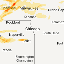
| 2:46 AM UTC | Quarter sized hail reported near Rochelle, IL, 73.6 miles W of Chicago, IL, relayed by media |
| 3:05 AM UTC | Ping Pong Ball sized hail reported near Princeton, IL, 47.9 miles N of Peoria, IL |
| 3:23 AM UTC | Inflow of 59 mph. wall cloud spotted 5 miles west of tonic in la salle county IL, 59.9 miles NE of Peoria, IL |
| 3:28 AM UTC | Golf Ball sized hail reported near Ladd, IL, 51.2 miles NNE of Peoria, IL, golfball size hail at mile marker 72 on interstate 80. |
| 3:28 AM UTC | Golf Ball sized hail reported near Peru, IL, 51.6 miles NNE of Peoria, IL, i 80. mm 72 |
| 4:03 AM UTC | Ping Pong Ball sized hail reported near Morris, IL, 54.4 miles SW of Chicago, IL, 2690 airport road. just north of morris. |
| 4:06 AM UTC | Golf Ball sized hail reported near Minooka, IL, 43.7 miles SW of Chicago, IL |
| 4:10 AM UTC | Half Dollar sized hail reported near Minooka, IL, 44 miles SW of Chicago, IL, 1 inch hail covering roads. some 1 1/2 inch hail mixed in. |
| 4:10 AM UTC | Golf Ball sized hail reported near Minooka, IL, 43.7 miles SW of Chicago, IL, last two minutes. |
| 4:11 AM UTC | Quarter sized hail reported near Minooka, IL, 43.7 miles SW of Chicago, IL, minooka road 2 miles east of route 47. covering road. |
| 4:12 AM UTC | Golf Ball sized hail reported near Minooka, IL, 43.7 miles SW of Chicago, IL, i-80 and ridge road. |
| 4:15 AM UTC | Quarter sized hail reported near Channahon, IL, 43.7 miles SW of Chicago, IL, covering ground west of route 6 and minooka road. |
| 4:15 AM UTC | Quarter sized hail reported near Minooka, IL, 43.7 miles SW of Chicago, IL |
| 4:16 AM UTC | Golf Ball sized hail reported near Channahon, IL, 43.7 miles SW of Chicago, IL, rt 80 and 55 |
| 5:05 AM UTC | Storm damage reported in fulton county IL, 25.5 miles WSW of Peoria, IL |
Texas
| Local Time | Report Details |
|---|---|
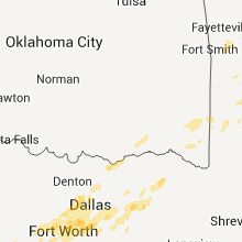
| 2:53 AM UTC | Golf Ball sized hail reported near Abilene, TX, 0.7 miles E of Abilene, TX, golfball size hail reported on texas avenue. |
| 3:50 AM CDT | Ping Pong Ball sized hail reported near Fort Worth, TX, 28.1 miles W of Dallas, TX, hail up to the size of 1.50" fell for nearly 15 minutes in watauga |
| 8:51 AM UTC | Half Dollar sized hail reported near Fort Worth, TX, 31.7 miles W of Dallas, TX, nickel to half dollar hail falling at the nws office in ft worth |
| 3:55 AM CDT | Half Dollar sized hail reported near Fort Worth, TX, 28.1 miles W of Dallas, TX |
| 9:08 AM UTC | Quarter sized hail reported near Euless, TX, 20.8 miles W of Dallas, TX, quarter hail in hurst |
| 9:49 AM UTC | Quarter sized hail reported near Alvarado, TX, 32.5 miles SW of Dallas, TX, one inch diameter hail near venus |
| 9:56 AM UTC | Quarter sized hail reported near Dallas, TX, 1.1 miles ESE of Dallas, TX, penny to quarter hail near the intersection of nw highway and inwood (near kdal). |
| 10:15 AM UTC | Quarter sized hail reported near Cedar Park, TX, 42.2 miles S of Killeen, TX |
| 10:30 AM UTC | Trees down with numerous power outages in and around crowley in tarrant county TX, 33.5 miles WSW of Dallas, TX |
| 10:50 AM UTC | Quarter sized hail reported near Arlington, TX, 19.2 miles W of Dallas, TX, quarter size hail occurred at martin hs in south arlington. time estimated from radar. |
| 11:05 AM UTC | 60 mph wind gusts with 2 blown transformers in johnson county TX, 29.2 miles SW of Dallas, TX |
| 11:53 AM UTC | Numerous trees down near west end of lake fork...state highway 19...and county roads 3150...3325...and 440 in rains county TX, 65 miles E of Dallas, TX |
Tennessee
| Local Time | Report Details |
|---|---|
| 7:15 AM UTC | Public reports 1-2 foot diameter trees snapped in half near clover bottom mansion on lebanon road intersection with disspayne driv in davidson county TN, 3.8 miles E of Nashville, TN |
Indiana
| Local Time | Report Details |
|---|---|
| 8:20 AM UTC | House damaged by high winds near county road 322 south and 900 wes in warren county IN, 70.4 miles WNW of Indianapolis, IN |
| 9:10 AM UTC | Large pine tree uproote in kosciusko county IN, 42.7 miles WNW of Fort Wayne, IN |
| 9:14 AM UTC | Storm damage reported in kosciusko county IN, 36.2 miles WNW of Fort Wayne, IN |
| 9:15 AM UTC | Tree fell on to home on wexford place. report from warsaw times-unio in kosciusko county IN, 38.8 miles WNW of Fort Wayne, IN |
| 9:26 AM UTC | Power line down 230 rail road street and tree across the road at main street and pleasant street in whitley county IN, 15.7 miles NW of Fort Wayne, IN |
| 9:43 AM UTC | Storm damage reported in grant county IN, 46.2 miles SW of Fort Wayne, IN |
Kentucky
| Local Time | Report Details |
|---|---|
| 9:00 AM UTC | At mile marker 18 along intersta in whitley county KY, 61 miles S of Irvine, KY |
Arkansas
| Local Time | Report Details |
|---|---|
| 9:54 AM UTC | Quarter sized hail reported near Atkins, AR, 46.2 miles NW of Little Rock, AR, several small tree limbs were also being blown down by wind. |
| 11:46 AM UTC | Golf Ball sized hail reported near Marshall, AR, 81.2 miles NNW of Little Rock, AR |
| 11:54 AM UTC | Multiple trees have fallen along hwy 5. pea to dime size hail is also fallin in searcy county AR, 82.7 miles NNW of Little Rock, AR |
West Virginia
| Local Time | Report Details |
|---|---|
| 10:30 AM UTC | Trees and powerlines dow in lincoln county WV, 10.7 miles WSW of Charleston, WV |
| 10:32 AM UTC | Large tree and powerlines down on alum creek road in kanawha county WV, 8.2 miles WSW of Charleston, WV |
Connect with Interactive Hail Maps