

Hail Map for Sunday, August 19, 2018

Number of Impacted Households on 8/19/2018
0
Impacted by 1" or Larger Hail
0
Impacted by 1.75" or Larger Hail
0
Impacted by 2.5" or Larger Hail
Square Miles of Populated Area Impacted on 8/19/2018
0
Impacted by 1" or Larger Hail
0
Impacted by 1.75" or Larger Hail
0
Impacted by 2.5" or Larger Hail


Cities Most Affected by Hail Storms of 8/19/2018
| Hail Size | Demographics of Zip Codes Affected | ||||||
|---|---|---|---|---|---|---|---|
| City | Count | Average | Largest | Pop Density | House Value | Income | Age |
| Clarksville, AR | 1 | 1.75 | 1.75 | 113 | $63k | $28.4k | 34.5 |
Hail and Wind Damage Spotted on 8/19/2018
Filter by Report Type:Hail ReportsWind Reports
States Impacted
Oklahoma, Virginia, Arkansas, Missouri, Arizona, North Carolina, Kansas, South Carolina, NebraskaOklahoma
| Local Time | Report Details |
|---|---|
| 3:40 PM CDT | Barn destroyed... several other outbuildings damaged or destroyed. lots of tree damage. possible tornad in mayes county OK, 32.6 miles E of Tulsa, OK |
| 4:01 PM CDT | Barns and outbuildings damaged along highway 69 near mazie. likely tornado damage. approximate locatio in mayes county OK, 35.5 miles E of Tulsa, OK |
Virginia
| Local Time | Report Details |
|---|---|
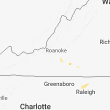
| 5:05 PM EDT | Quarter sized hail reported near Gretna, VA, 43.5 miles ESE of Roanoke, VA, quarter size hail reported at the intersection of route 40 and route 685 near chalk level. |
| 5:25 PM EDT | Tree down on vehicl in prince edward county VA, 46.1 miles WSW of Richmond, VA |
Arkansas
| Local Time | Report Details |
|---|---|
| 5:45 PM CDT | Quarter sized hail reported near Clarksville, AR, 51.1 miles E of Fort Smith, AR |
| 5:48 PM CDT | Quarter sized hail reported near Clarksville, AR, 53.9 miles E of Fort Smith, AR |
| 5:50 PM CDT | Golf Ball sized hail reported near Clarksville, AR, 53.9 miles E of Fort Smith, AR |
| 8:50 PM CDT | Report of a tree down near lake hamilton. there are also several power outages through the lake hamilton regio in garland county AR, 51.4 miles WSW of Little Rock, AR |
| 9:25 PM CDT | A tree was blown dow in cleburne county AR, 65 miles N of Little Rock, AR |
| 9:45 PM CDT | Storm damage reported in perry county AR, 30.5 miles NW of Little Rock, AR |
| 10:10 PM CDT | Downed trees and power lines... as well as damage to a mobile home. several areas without powe in conway county AR, 43.1 miles NNW of Little Rock, AR |
| 11:04 PM CDT | Limbs were blown dow in white county AR, 41.7 miles NNE of Little Rock, AR |
Missouri
| Local Time | Report Details |
|---|---|
| 5:47 PM CDT | Storm damage reported in jasper county MO, 50.9 miles W of Springfield, MO |
| 7:03 PM CDT | Multiple tree limbs down with minor damage to outbuildings. time estimated by rada in greene county MO, 13.9 miles WSW of Springfield, MO |
| 7:21 PM CDT | Spotter reports downed power lines at the intersection of south illinois ave and melody lane southwest of republic. spotter also sees several large tree branches... and in greene county MO, 13.3 miles SW of Springfield, MO |
| 7:23 PM CDT | Spotter reported an estimated 60mph wind gust and a large tree down blocking a roadway. time estimated from rada in greene county MO, 13 miles WSW of Springfield, MO |
| 7:26 PM CDT | Large tree limb down on car. time estimated by rada in polk county MO, 27.7 miles NNW of Springfield, MO |
| 7:29 PM CDT | Report of barn roof blown off at south 210th and highway y in polk county MO, 24.3 miles N of Springfield, MO |
Arizona
| Local Time | Report Details |
|---|---|
| 4:20 PM MST | Quarter sized hail reported near Douglas, AZ, 6.6 miles WNW of Douglas, AZ, spotter west of douglas estimated 1" hail. |
North Carolina
| Local Time | Report Details |
|---|---|
| 8:05 PM EDT | Large tree down at old us 501 highway and fontaine rd in bethel hil in person county NC, 52 miles NNW of Raleigh, NC |
| 8:33 PM EDT | Multiple trees down on brumley rd near the bridg in iredell county NC, 24.3 miles N of Charlotte, NC |
| 10:40 PM EDT | Tree down at tar river rd and hester r in granville county NC, 25.9 miles N of Raleigh, NC |
Kansas
| Local Time | Report Details |
|---|---|
| 7:17 PM CDT | Quarter sized hail reported near Victoria, KS, 10.8 miles SE of Hays, KS, quarter sized hail reported. |
| 7:50 PM CDT | Delayed report...estimated at the intersection of highways 4 and 28 in barton county KS, 35.9 miles SE of Hays, KS |
South Carolina
| Local Time | Report Details |
|---|---|
| 8:50 PM EDT | Tree down due to thunderstorm outflow on interstate 95 near milemarker 1 in jasper county SC, 24.6 miles NNE of Savannah, GA |
Nebraska
| Local Time | Report Details |
|---|---|
| 5:13 AM CDT | Storm damage reported in douglas county NE, 3.8 miles NE of Omaha, NE |
Connect with Interactive Hail Maps