

Hail Map for Saturday, August 27, 2016

Number of Impacted Households on 8/27/2016
0
Impacted by 1" or Larger Hail
0
Impacted by 1.75" or Larger Hail
0
Impacted by 2.5" or Larger Hail
Square Miles of Populated Area Impacted on 8/27/2016
0
Impacted by 1" or Larger Hail
0
Impacted by 1.75" or Larger Hail
0
Impacted by 2.5" or Larger Hail


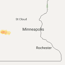


Cities Most Affected by Hail Storms of 8/27/2016
| Hail Size | Demographics of Zip Codes Affected | ||||||
|---|---|---|---|---|---|---|---|
| City | Count | Average | Largest | Pop Density | House Value | Income | Age |
| Arvilla, ND | 2 | 2.13 | 2.50 | 4 | $58k | $28.1k | 47.4 |
| Rothsay, MN | 2 | 1.75 | 1.75 | 5 | $48k | $35.1k | 41.0 |
| Reynolds, ND | 1 | 2.50 | 2.50 | 6 | $71k | $45.4k | 42.1 |
| Fargo, ND | 1 | 2.00 | 2.00 | 965 | $92k | $31.8k | 30.8 |
| Leoti, KS | 1 | 1.75 | 1.75 | 2 | $56k | $33.3k | 39.7 |
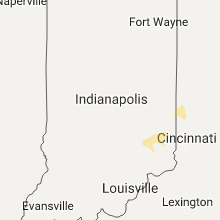
Hail and Wind Damage Spotted on 8/27/2016
Filter by Report Type:Hail ReportsWind Reports
States Impacted
Indiana, Ohio, North Dakota, Minnesota, North Carolina, Michigan, Tennessee, Kentucky, Kansas, Texas, South DakotaIndiana
| Local Time | Report Details |
|---|---|
| 1:15 PM EDT | Several trees downed in the napoleon area. time estimated by rada in ripley county IN, 44.9 miles W of Cincinnati, OH |
| 1:20 PM EDT | Numerous trees down along route 229. time estimated based on rada in ripley county IN, 40.7 miles WNW of Cincinnati, OH |
| 1:25 PM EDT | Trees and power lines down near indian lakes campground. time estimated based on rada in ripley county IN, 35.4 miles WNW of Cincinnati, OH |
| 1:30 PM EDT | Numerous trees downed in the indian lake area... including one onto a house and some onto campers. numerous other trees were downed in the batesville and sunman area in ripley county IN, 35.4 miles WNW of Cincinnati, OH |
| 1:55 PM EDT | Numerous trees down on st route 46 1/2 mile west of st peters road in dearborn county IN, 32.1 miles WNW of Cincinnati, OH |
| 1:55 PM EDT | Numerous trees down at 28000 block of barber road. time estimated based on rada in dearborn county IN, 23.4 miles WNW of Cincinnati, OH |
| 2:00 PM EDT | Numerous trees down on us-52 near st peters roa in franklin county IN, 25.4 miles WNW of Cincinnati, OH |
| 2:00 PM EDT | Numerous trees down on us-52 near st peters roa in franklin county IN, 25.4 miles WNW of Cincinnati, OH |
Ohio
| Local Time | Report Details |
|---|---|
| 1:40 PM EDT | Construction trailer tipped on its sid in fulton county OH, 61.6 miles NE of Fort Wayne, IN |
| 2:20 PM EDT | Numerous large trees down across northwest portions of the county... especially to the east of oxford. time esimated by rada in butler county OH, 30.7 miles NNW of Cincinnati, OH |
| 2:24 PM EDT | Numerous trees downed in butler county OH, 28.7 miles N of Cincinnati, OH |
| 2:26 PM EDT | Storm damage reported in lucas county OH, 75.9 miles ENE of Fort Wayne, IN |
| 2:30 PM EDT | Numerous large trees down and power lines down across the southern part of preble count in preble county OH, 39.3 miles NNW of Cincinnati, OH |
| 2:35 PM EDT | 1 ft diameter tree snapped and struck house in preble county OH, 37.5 miles N of Cincinnati, OH |
| 2:42 PM EDT | Numerous 3-4 inch branches down on yankee road near state route 63 in butler county OH, 23.8 miles NNE of Cincinnati, OH |
| 2:45 PM EDT | Numerous trees down in preble county OH, 51.3 miles N of Cincinnati, OH |
| 2:51 PM EDT | 2 ft diameter tree down at franklin-trenton and hobart in warren county OH, 32.6 miles NNE of Cincinnati, OH |
| 3:00 PM EDT | Storm damage reported in montgomery county OH, 47 miles NNE of Cincinnati, OH |
| 3:10 PM EDT | Trees down in montgomery county OH, 55.7 miles N of Cincinnati, OH |
| 3:17 PM EDT | Numerous trees down in montgomery county OH, 52.5 miles N of Cincinnati, OH |
| 3:18 PM EDT | Numerous large branches and wires dow in miami county OH, 59.6 miles N of Cincinnati, OH |
| 3:20 PM EDT | Storm damage reported in greene county OH, 55.5 miles NNE of Cincinnati, OH |
| 4:10 PM EDT | Large branches and wires down in mechanicsburg and elsewhere across southern portions of champaign count in champaign county OH, 30.5 miles WNW of Columbus, OH |
| 4:10 PM EDT | Large tree snapped in half in champaign county OH, 40.9 miles WNW of Columbus, OH |
| 6:04 PM EDT | Tree down stevens road. relayed by richland county sheriff. time estimated from rada in richland county OH, 55.4 miles NNE of Columbus, OH |
| 6:18 PM EDT | Limbs down east of butler. relayed by richland county sheriff. time estimated from rada in richland county OH, 55.4 miles NE of Columbus, OH |
| 6:40 PM EDT | A few trees down along arion road. time estimated by rada in scioto county OH, 76.9 miles S of Columbus, OH |
| 8:07 PM EDT | Akron canton airport asos in summit county OH, 42.6 miles SSE of Cleveland, OH |
| 10:09 PM EDT | Tree down in crawford county OH, 54.2 miles NNE of Columbus, OH |
| 10:09 PM EDT | Tree down in crawford county OH, 54.2 miles NNE of Columbus, OH |
North Dakota
| Local Time | Report Details |
|---|---|
| 1:10 PM CDT | Quarter sized hail reported near West Fargo, ND, 5.6 miles W of Fargo, ND, mostly nickel to quarter size hail. winds estimated 40 mph. |
| 1:14 PM CDT | Quarter sized hail reported near Fargo, ND, 1.8 miles W of Fargo, ND |
| 1:19 PM CDT | Quarter sized hail reported near Fargo, ND, 1.8 miles W of Fargo, ND, slightly larger than quarter hail at ndsu. |
| 1:24 PM CDT | Hen Egg sized hail reported near Fargo, ND, 1.8 miles W of Fargo, ND, photo via social media from north fargo. time estimated. |
| 3:23 PM CDT | Quarter sized hail reported near Grafton, ND, 70.4 miles ENE of Devils Lake, ND, pea to quarter size hail on hwy 81 at pembina/walsh county line. |
| 3:37 PM CDT | Half Dollar sized hail reported near Grafton, ND, 70.4 miles ENE of Devils Lake, ND, walnut sized hail reported at us 81 at walsh/pembina county line. |
| 3:41 PM CDT | Golf Ball sized hail reported near Arvilla, ND, 64.8 miles ESE of Devils Lake, ND, via social media. |
| 3:41 PM CDT | Tennis Ball sized hail reported near Arvilla, ND, 64.8 miles ESE of Devils Lake, ND, relayed via social media. size estimated from photo. |
| 3:52 PM CDT | Quarter sized hail reported near Grafton, ND, 64.7 miles ENE of Devils Lake, ND |
| 4:29 PM CDT | Quarter sized hail reported near Grafton, ND, 70.5 miles ENE of Devils Lake, ND |
| 5:18 PM CDT | Tennis Ball sized hail reported near Reynolds, ND, 63.2 miles NNW of Fargo, ND, via photo on social media. time estimated from radar. |
| 5:40 PM CDT | Ping Pong Ball sized hail reported near Buxton, ND, 52.2 miles NNW of Fargo, ND |
Minnesota
| Local Time | Report Details |
|---|---|
| 1:20 PM CDT | Quarter sized hail reported near Moorhead, MN, 1.5 miles SE of Fargo, ND, pea to quarter size hail in north moorhead. |
| 2:53 PM CDT | Quarter sized hail reported near Rothsay, MN, 38.6 miles SSE of Fargo, ND |
| 2:57 PM CDT | Golf Ball sized hail reported near Rothsay, MN, 38.6 miles SSE of Fargo, ND, hail covering the ground. |
| 3:05 PM CDT | Golf Ball sized hail reported near Rothsay, MN, 38.6 miles SSE of Fargo, ND, hail up to golfball size at county road 16 and 270th avenue. drifts of hail up to 1 ft on edge of road with hail covering road. crop damage due to hail. |
| 4:56 PM CDT | Quarter sized hail reported near Foxhome, MN, 46.1 miles SSE of Fargo, ND |
| 7:27 PM CDT | Ping Pong Ball sized hail reported near Perley, MN, 20.3 miles N of Fargo, ND |
| 8:18 PM CDT | Ping Pong Ball sized hail reported near Glyndon, MN, 14.8 miles ENE of Fargo, ND, measured hail well after it had fallen. |
| 5:25 AM CDT | Multiple trees dow in chippewa county MN, 5.2 miles NE of Montevideo, MN |
North Carolina
| Local Time | Report Details |
|---|---|
| 2:55 PM EDT | Trained spotter reported a tree down on sides rd in rockwell in rowan county NC, 33.9 miles NE of Charlotte, NC |
| 3:08 PM EDT | Public reported trees down on millbridge rd near china grove in rowan county NC, 30 miles NNE of Charlotte, NC |
| 3:15 PM EDT | One tree down blocking the road at the 300 block of holly springs rd. time estimated by rada in wake county NC, 14.1 miles SW of Raleigh, NC |
| 3:21 PM EDT | One tree down on a residence on lakeview driv in moore county NC, 54.3 miles SW of Raleigh, NC |
| 4:00 PM EDT | Trees down along river road at highway 1 in burke county NC, 50.6 miles NW of Charlotte, NC |
| 4:08 PM EDT | Power-lines were blown down. in montgomery county NC, 59.5 miles ENE of Charlotte, NC |
| 4:30 PM EDT | Small tree limbs blown dow in alexander county NC, 50.2 miles NNW of Charlotte, NC |
| 4:30 PM EDT | Power-lines blown down near montgomery memorial hospita in montgomery county NC, 54.4 miles E of Charlotte, NC |
| 5:10 PM EDT | Trees down on veterans drive in mario in mcdowell county NC, 64 miles S of Bristol, TN |
| 5:16 PM EDT | One tree was reported down near the intersection of highway 731 and highway 52. in stanly county NC, 41.2 miles E of Charlotte, NC |
| 5:20 PM EDT | One tree was blown down near the intersection of nc highway 52 and old us 52. in anson county NC, 41.2 miles E of Charlotte, NC |
| 5:23 PM EDT | Media reports tree down on house in north cov in mcdowell county NC, 53.4 miles SSE of Bristol, TN |
| 5:25 PM EDT | Tree down in pleasant garden community along highway 70 and river roa in mcdowell county NC, 63.5 miles S of Bristol, TN |
| 5:25 PM EDT | Reports of mulitple trees and powerlines blown down across central gaston county including dallas...center city...and gastoni in gaston county NC, 18.9 miles W of Charlotte, NC |
| 5:25 PM EDT | A few trees and large limbs blown down and a few reports of power outage in guilford county NC, 63.1 miles WNW of Raleigh, NC |
| 5:27 PM EDT | One tree was reported donw on cocoa drive... near woodedge driv in guilford county NC, 65.5 miles WNW of Raleigh, NC |
| 5:30 PM EDT | Small limbs down on piedmont avenue and cansler stree in cleveland county NC, 28.6 miles W of Charlotte, NC |
| 5:30 PM EDT | Power-lines blown down near montgomery memorial hospita in montgomery county NC, 54.4 miles E of Charlotte, NC |
| 5:36 PM EDT | Spotter reports several trees down on powerlines on hwy 1 in cleveland county NC, 42.4 miles WNW of Charlotte, NC |
| 5:38 PM EDT | One tree down on hastings hill road. in forsyth county NC, 73.3 miles NNE of Charlotte, NC |
| 5:45 PM EDT | Trees and power lines down along highway 18 on east side of shelb in cleveland county NC, 39.1 miles W of Charlotte, NC |
Michigan
| Local Time | Report Details |
|---|---|
| 3:00 PM EDT | Wires down. report via twitte in monroe county MI, 76.8 miles SSE of Flint, MI |
Tennessee
| Local Time | Report Details |
|---|---|
| 2:40 PM CDT | Time estimated based on rada in wilson county TN, 37 miles ESE of Nashville, TN |
| 4:35 PM EDT | Trees down in maryville in blount county TN, 14.8 miles S of Knoxville, TN |
| 4:04 PM CDT | 6-8 inch diameter tree down at iroquois steeplechase in davidson county TN, 10.1 miles SW of Nashville, TN |
| 4:10 PM CDT | Large tree limb blown down in bellevu in davidson county TN, 9.2 miles SW of Nashville, TN |
| 5:33 PM EDT | Trees down across meigs county...specifically near decatu in meigs county TN, 44.4 miles NE of Chattanooga, TN |
| 5:45 PM EDT | Power lines...several small trees/limbs down in maryville. damage to roofs on some businesses in the downtown are in blount county TN, 14.8 miles S of Knoxville, TN |
Kentucky
| Local Time | Report Details |
|---|---|
| 6:00 PM CDT | Trees reported down along with damage to a mobile home. trees down in multiple location in adair county KY, 65.2 miles SSE of Louisville, KY |
Kansas
| Local Time | Report Details |
|---|---|
| 6:06 PM CDT | A 4 inch tree limb blown out of tre in franklin county KS, 49.3 miles SW of Kansas City, MO |
| 6:26 PM CDT | A couple trees blown ove in franklin county KS, 50.4 miles SW of Kansas City, MO |
| 6:26 PM CDT | Tree fell on house...no specifics on size or health of the tree...reports of power outages as well...no specifics on how many without power in franklin county KS, 49.8 miles SW of Kansas City, MO |
| 6:48 PM CDT | Golf Ball sized hail reported near Leoti, KS, 34.1 miles NW of Garden City, KS, estimated 30-40 mph winds. |
| 6:16 PM MDT | Quarter sized hail reported near Weskan, KS, 63.7 miles SW of Colby, KS, hail covering ground. hail ending at time of event. |
| 7:02 PM MDT | Quarter sized hail reported near Tribune, KS, 65 miles SW of Colby, KS, time estimated by radar. nickel to quarter size hail. |
Texas
| Local Time | Report Details |
|---|---|
| 6:45 PM MDT | Half Dollar sized hail reported near El Paso, TX, 32.6 miles E of El Paso, TX, motorists encountered half dollar sized hail about 2 mi west of the border patrol check point. smaller hail observed at the checkpoint itself. |
| 8:05 PM MDT | Chamizal nat memorial tceq in el paso county TX, 1.8 miles ENE of El Paso, TX |
South Dakota
| Local Time | Report Details |
|---|---|
| 3:10 AM CDT | Quarter sized hail reported near Webster, SD, 47.8 miles E of Aberdeen, SD, social media report with time estimated based off radar. |
| 3:32 AM CDT | Quarter sized hail reported near Waubay, SD, 57.9 miles E of Aberdeen, SD, . |
Connect with Interactive Hail Maps