

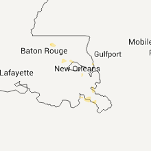
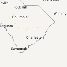
Hail Map for Friday, August 5, 2011

Number of Impacted Households on 8/5/2011
0
Impacted by 1" or Larger Hail
0
Impacted by 1.75" or Larger Hail
0
Impacted by 2.5" or Larger Hail
Square Miles of Populated Area Impacted on 8/5/2011
0
Impacted by 1" or Larger Hail
0
Impacted by 1.75" or Larger Hail
0
Impacted by 2.5" or Larger Hail


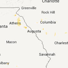


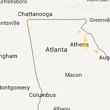


Cities Most Affected by Hail Storms of 8/5/2011
| Hail Size | Demographics of Zip Codes Affected | ||||||
|---|---|---|---|---|---|---|---|
| City | Count | Average | Largest | Pop Density | House Value | Income | Age |
| Elgin, ND | 1 | 1.75 | 1.75 | 2 | $29k | $22.4k | 56.2 |
Hail and Wind Damage Spotted on 8/5/2011
Filter by Report Type:Hail ReportsWind Reports
States Impacted
Missouri, Tennessee, Illinois, North Dakota, South Dakota, Wyoming, Montana, Minnesota, Florida, South Carolina, Georgia, Oklahoma, Idaho, Texas, NebraskaMissouri
| Local Time | Report Details |
|---|---|
| 1:30 PM UTC | A thunderstorm wind gust caused damage to occur to a wooden swing set in the southern part of the city of ozar in christian county MO, 21.8 miles SSE of Springfield, MO |
Tennessee
| Local Time | Report Details |
|---|---|
| 4:40 PM UTC | Trees blown down on dr. d. b. todd jr in davidson county TN, 0.2 miles NNW of Nashville, TN |
| 8:40 PM UTC | A couple of trees dow in marion county TN, 12.7 miles WNW of Chattanooga, TN |
Illinois
| Local Time | Report Details |
|---|---|
| 7:15 PM UTC | One large tree down snapped power lines in downtown mariss in st. clair county IL, 35.2 miles SE of Saint Louis, MO |
North Dakota
| Local Time | Report Details |
|---|---|
| 7:54 PM UTC | Also nickel size hail in bowman county ND, 101.1 miles E of Miles City, MT |
| 8:58 PM UTC | Quarter sized hail reported near Belfield, ND, 89.1 miles SSE of Williston, ND, relayed by media. |
| 9:20 PM UTC | Half Dollar sized hail reported near Belfield, ND, 89.1 miles SSE of Williston, ND, relayed by media. |
| 9:35 PM UTC | 50-60 mph wind gus in stark county ND, 95.3 miles W of Bismarck, ND |
| 9:47 PM UTC | Storm damage reported in stark county ND, 95.5 miles W of Bismarck, ND |
| 9:54 PM UTC | Law enforcement estimated 70 to 80 mph winds on i-94 east of dickinso in stark county ND, 91.7 miles W of Bismarck, ND |
| 10:45 PM UTC | 6 to 8 inch diameter trees snapped. estimated 70 mile per hour winds. strong winds lasted 10 to 15 minutes. 1.80 inch precipitatio in morton county ND, 49.9 miles W of Bismarck, ND |
| 10:50 PM UTC | 2 to 3 inch diameter trees blown over. winds estimated 65-70 mp in morton county ND, 60.1 miles W of Bismarck, ND |
| 10:53 PM UTC | Estimated wind gusts of at least 60 mph. zero visibility. winds ongoing. report relayed by warning poin in morton county ND, 49.9 miles W of Bismarck, ND |
| 11:15 PM UTC | Storm damage reported in morton county ND, 30.1 miles W of Bismarck, ND |
| 11:20 PM UTC | Golf Ball sized hail reported near Elgin, ND, 58.9 miles WSW of Bismarck, ND |
| 12:32 AM UTC | Estimated 60 mph wind gust at horizon middle schoo in burleigh county ND, 1.4 miles NW of Bismarck, ND |
South Dakota
| Local Time | Report Details |
|---|---|
| 8:00 PM UTC | Marble size hail als in butte county SD, 72.1 miles NNW of Rapid City, SD |
| 8:27 PM UTC | Ping Pong Ball sized hail reported near Belle Fourche, SD, 66.1 miles NNW of Rapid City, SD, also had 60 mph winds |
| 8:30 PM UTC | Also had 1.5 inch hail at 227 pm to 230 pm in butte county SD, 66.1 miles NNW of Rapid City, SD |
| 9:30 PM UTC | Storm damage reported in butte county SD, 61.5 miles N of Rapid City, SD |
| 9:46 PM UTC | Storm damage reported in butte county SD, 77.6 miles N of Rapid City, SD |
| 10:00 PM UTC | Storm damage reported in meade county SD, 56.5 miles NNE of Rapid City, SD |
| 10:00 PM UTC | Quarter sized hail reported near Vale, SD, 38.1 miles NNW of Rapid City, SD, also had 30 to 40 mph winds. |
| 10:00 PM UTC | Quarter sized hail reported near Newell, SD, 40.2 miles NNW of Rapid City, SD, 40 mph winds. |
| 10:00 PM UTC | Half Dollar sized hail reported near Newell, SD, 41.7 miles NNW of Rapid City, SD, also had 30 mph winds. |
| 10:30 PM UTC | Quarter sized hail reported near Hermosa, SD, 16.1 miles S of Rapid City, SD, shredded leaves and car dents |
| 10:35 PM UTC | Quarter sized hail reported near Hermosa, SD, 14.8 miles S of Rapid City, SD, 0.60 inches of rain. ground is white from the hail. |
| 10:35 PM UTC | Ping Pong Ball sized hail reported near Keystone, SD, 15.4 miles SSW of Rapid City, SD |
| 10:43 PM UTC | 8 inch diameter tree branches broke in meade county SD, 54.4 miles NE of Rapid City, SD |
| 10:47 PM UTC | Quarter sized hail reported near Hermosa, SD, 17.4 miles SSW of Rapid City, SD |
| 10:47 PM UTC | Ping Pong Ball sized hail reported near Hermosa, SD, 18.8 miles S of Rapid City, SD |
| 10:50 PM UTC | Storm damage reported in perkins county SD, 110 miles NNE of Rapid City, SD |
| 11:00 PM UTC | Storm damage reported in meade county SD, 43.2 miles NE of Rapid City, SD |
| 11:00 PM UTC | Storm damage reported in perkins county SD, 107.6 miles NNE of Rapid City, SD |
| 11:10 PM UTC | Quarter sized hail reported near Hermosa, SD, 23.6 miles S of Rapid City, SD |
| 11:18 PM UTC | Wind gust at faith aso in perkins county SD, 89.2 miles NE of Rapid City, SD |
| 11:30 PM UTC | Also had pea size hai in custer county SD, 29.8 miles SSE of Rapid City, SD |
| 11:40 PM UTC | Wind gusting to 50 to 60 mph with hail 3/8 inc in meade county SD, 43.5 miles NE of Rapid City, SD |
| 11:40 PM UTC | Wind gusting to 50 to 60 mph with hail 3/8 inc in meade county SD, 40.7 miles NE of Rapid City, SD |
| 11:50 PM UTC | Roof blown off of structur in dewey county SD, 87 miles NNW of Pierre, SD |
| 12:15 AM UTC | Sdsu mesonet sit in dewey county SD, 81.3 miles NNW of Pierre, SD |
| 12:25 AM UTC | Storm damage reported in haakon county SD, 68.3 miles ENE of Rapid City, SD |
| 12:25 AM UTC | Wind gust of 60 to 70 mp in haakon county SD, 70.6 miles ENE of Rapid City, SD |
| 12:45 AM UTC | Storm damage reported in dewey county SD, 61.8 miles NW of Pierre, SD |
| 12:55 AM UTC | Storm damage reported in corson county SD, 70.8 miles S of Bismarck, ND |
| 1:00 AM UTC | Storm damage reported in shannon county SD, 64.5 miles SE of Rapid City, SD |
| 1:17 AM UTC | Storm damage reported in harding county SD, 91.5 miles NNW of Rapid City, SD |
| 1:20 AM UTC | Storm damage reported in stanley county SD, 26.1 miles WSW of Pierre, SD |
| 2:10 AM UTC | I-90 mile marker 172 in jackson county SD, 48.8 miles SW of Pierre, SD |
| 4:10 AM UTC | Storm damage reported in tripp county SD, 61.7 miles SSE of Pierre, SD |
| 4:40 AM UTC | Large branches dow in brule county SD, 64.7 miles SE of Pierre, SD |
| 4:40 AM UTC | Thunderstorm winds blew pickup and attached trailer through 2 fences and into a ditch along highway 50. the winds also blew off the side and roof of a bar in brule county SD, 63.4 miles ESE of Pierre, SD |
| 4:50 AM UTC | Numerous trees dow in brule county SD, 71 miles SE of Pierre, SD |
| 5:08 AM UTC | Numerous branches in brule county SD, 81.6 miles SE of Pierre, SD |
| 5:10 AM UTC | Several trees dow in brule county SD, 81.3 miles ESE of Pierre, SD |
| 5:30 AM UTC | House shakin in aurora county SD, 81.6 miles N of Oneill, NE |
Wyoming
| Local Time | Report Details |
|---|---|
| 8:00 PM UTC | Marble size hail als in crook county WY, 72.6 miles NW of Rapid City, SD |
| 9:59 PM UTC | Buffalo asos reported a 60 mph wind gust from a thunderstorm at 1559l in johnson county WY, 60.3 miles W of Gillette, WY |
| 11:47 PM UTC | Quarter sized hail reported near Moorcroft, WY, 38 miles NE of Gillette, WY |
| 12:00 AM UTC | Quarter sized hail reported near Weston, WY, 38.7 miles NNE of Gillette, WY, quarter size |
Montana
| Local Time | Report Details |
|---|---|
| 8:18 PM UTC | Quarter sized hail reported near Savage, MT, 60.9 miles SSW of Williston, ND, estimated 1 inch hail. zero visibility. 45 to 50 mph wind. along highway 16. |
| 10:04 PM UTC | Storm damage reported in yellowstone county MT, 4.4 miles NW of Billings, MT |
| 10:19 PM UTC | Accompanied by pea sized hai in yellowstone county MT, 4.2 miles NE of Billings, MT |
Minnesota
| Local Time | Report Details |
|---|---|
| 8:24 PM UTC | 10 inch diameter spruce tree down on highway 4 in itasca county MN, 55.3 miles E of Bemidji, MN |
| 9:27 PM UTC | Quarter sized hail reported near Leonard, MN, 22.8 miles WNW of Bemidji, MN |
| 10:00 PM UTC | Stop light blown down in beltrami county MN, 1.1 miles WNW of Bemidji, MN |
| 10:05 PM UTC | Stop light blown down...several trees down in beltrami county MN, 0.5 miles N of Bemidji, MN |
| 10:05 PM UTC | 60 foot 10 inch diameter pine blown over in beltrami county MN, 6.4 miles SW of Bemidji, MN |
| 10:15 PM UTC | Quarter sized hail reported near Bemidji, MN, 0.5 miles N of Bemidji, MN |
| 10:20 PM UTC | Trees down on power lines in beltrami county MN, 1.9 miles ENE of Bemidji, MN |
Florida
| Local Time | Report Details |
|---|---|
| 9:05 PM UTC | Public reported several large tree branches blown dow in baker county FL, 39 miles W of Jacksonville, FL |
South Carolina
| Local Time | Report Details |
|---|---|
| 9:57 PM UTC | Tree limbs down on good hope road east of norway. public estimated winds above 60 mp in orangeburg county SC, 52.9 miles E of Augusta, GA |
| 11:40 PM UTC | Tree down on shortcut roa in dorchester county SC, 25.3 miles W of Charleston, SC |
| 11:55 PM UTC | Tree blown down on roadway at candle light road in colleton county SC, 38.3 miles WSW of Charleston, SC |
| 11:59 PM UTC | Tree down blocking horseford roa in dorchester county SC, 21.7 miles WSW of Charleston, SC |
Georgia
| Local Time | Report Details |
|---|---|
| 10:12 PM UTC | The fire chief for carnesville reported trees and large limbs down in the area east of carnesville in franklin county GA, 46.7 miles SW of Greenville, SC |
| 10:17 PM UTC | Two trees blown down on highway 191...two trees blown down highway 98...two trees blown down on highway 172. also one tree blown down on power lines in carlto in madison county GA, 58.2 miles SSW of Greenville, SC |
| 10:30 PM UTC | The fire chief of carnesville said many more trees and limbs were down from the storm in the royston and franklin springs are in franklin county GA, 47.3 miles SW of Greenville, SC |
Oklahoma
| Local Time | Report Details |
|---|---|
| 11:06 PM UTC | Pole barn pushed 100 yards into house and debris scattered 0.25-0.50 miles past the house... caused damage to the house and overturned a swingse in texas county OK, 101.9 miles SW of Garden City, KS |
| 11:20 PM UTC | 66 mph winds recorded at mesonet 3 sse of boise city at 620pm in cimarron county OK, 108.6 miles NNW of Amarillo, TX |
| 11:30 PM UTC | Winds estimated at the intersection of garland and west chestnut in west enid in garfield county OK, 69.5 miles NNW of Oklahoma City, OK |
| 11:30 PM UTC | Delayed report of damage to large trees and light posts at the oakwood country club northwest of enid in garfield county OK, 69.1 miles NNW of Oklahoma City, OK |
| 12:58 AM UTC | 66 mph winds recorded at mesonet 3 sse of boise city at 620pm in cimarron county OK, 108.6 miles NNW of Amarillo, TX |
| 1:20 AM UTC | School net site in texas county OK, 96 miles N of Amarillo, TX |
| 1:47 AM UTC | Storm damage reported in texas county OK, 94.9 miles SSW of Garden City, KS |
| 5:55 AM UTC | Delayed repor in woods county OK, 42.3 miles ENE of Woodward, OK |
Idaho
| Local Time | Report Details |
|---|---|
| 11:30 PM UTC | Storm damage reported in bear lake county ID, 87 miles SSE of Idaho Falls, ID |
Texas
| Local Time | Report Details |
|---|---|
| 11:46 PM UTC | 59 mph wind gust recorded at kdht at 646 pm in hartley county TX, 69.6 miles NW of Amarillo, TX |
Nebraska
| Local Time | Report Details |
|---|---|
| 8:30 AM UTC | Estimated 50 to 60 mph winds with locally heavy rai in keya paha county NE, 43.7 miles E of Valentine, NE |
Connect with Interactive Hail Maps