

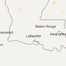
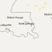
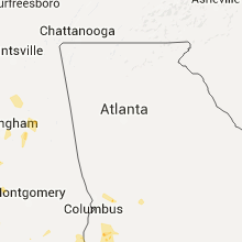
Hail Map for Sunday, July 10, 2016

Number of Impacted Households on 7/10/2016
0
Impacted by 1" or Larger Hail
0
Impacted by 1.75" or Larger Hail
0
Impacted by 2.5" or Larger Hail
Square Miles of Populated Area Impacted on 7/10/2016
0
Impacted by 1" or Larger Hail
0
Impacted by 1.75" or Larger Hail
0
Impacted by 2.5" or Larger Hail


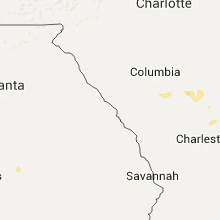


Cities Most Affected by Hail Storms of 7/10/2016
| Hail Size | Demographics of Zip Codes Affected | ||||||
|---|---|---|---|---|---|---|---|
| City | Count | Average | Largest | Pop Density | House Value | Income | Age |
| Killdeer, ND | 3 | 2.17 | 3.00 | 2 | $43k | $33.8k | 43.8 |
| Baker, MT | 3 | 1.92 | 2.00 | 0 | $49k | $30.7k | 42.1 |
| Amidon, ND | 2 | 2.25 | 2.75 | 1 | $32k | $26.9k | 55.5 |
| Plevna, MT | 2 | 1.75 | 1.75 | 0 | $24k | $27.3k | 49.7 |
| Reeder, ND | 1 | 2.50 | 2.50 | 1 | $21k | $24.6k | 49.5 |
| Bison, SD | 1 | 2.25 | 2.25 | 0 | $35k | $28.6k | 46.8 |
| Linton, ND | 1 | 2.00 | 2.00 | 2 | $43k | $26.4k | 50.6 |
| Rhame, ND | 1 | 1.75 | 1.75 | 0 | $31k | $22.9k | 47.0 |
| Fairfield, ND | 1 | 1.75 | 1.75 | 0 | $23k | $26.0k | 48.6 |
Hail and Wind Damage Spotted on 7/10/2016
Filter by Report Type:Hail ReportsWind Reports
States Impacted
North Dakota, Louisiana, Mississippi, Alabama, Arkansas, Wyoming, Georgia, Montana, South Carolina, Illinois, Missouri, Idaho, South Dakota, Texas, Nebraska, MinnesotaNorth Dakota
| Local Time | Report Details |
|---|---|
| 11:20 AM CDT | Estimated using rada in stutsman county ND, 83.4 miles S of Devils Lake, ND |
| 3:13 PM MDT | Half Dollar sized hail reported near Fairfield, ND, 70.1 miles SSE of Williston, ND, very heavy rain also. hail and rain ongoing. |
| 3:15 PM MDT | Golf Ball sized hail reported near Fairfield, ND, 65.4 miles SSE of Williston, ND, windows were breaking from hail and wind. |
| 3:15 PM MDT | Wind and hail were breaking window in billings county ND, 65.4 miles SSE of Williston, ND |
| 3:27 PM MDT | Ping Pong Ball sized hail reported near Grassy Butte, ND, 65.3 miles SSE of Williston, ND, ping pong ball size hail for 10 minutes. occurred from 427pm cdt and 437pm cdt. |
| 3:32 PM MDT | Quarter sized hail reported near Belfield, ND, 77 miles SSE of Williston, ND, . |
| 3:47 PM MDT | Golf Ball sized hail reported near Killdeer, ND, 67.5 miles SSE of Williston, ND, hail lasted through 457 pm cdt |
| 3:52 PM MDT | Golf Ball sized hail reported near Rhame, ND, 95 miles E of Miles City, MT, . |
| 3:52 PM MDT | Storm damage reported in slope county ND, 95 miles E of Miles City, MT |
| 4:00 PM MDT | Tea Cup sized hail reported near Killdeer, ND, 67.3 miles SE of Williston, ND, measured 3.25 inch hail and ongoing. windows broken. |
| 4:05 PM MDT | Golf Ball sized hail reported near Killdeer, ND, 72.5 miles SSE of Williston, ND, ongoing golf ball size hail. |
| 4:26 PM MDT | Window broken in patrol passenger vehicle. trees down with lots of damages to trailers and houses due to wind driven hail. damage is ongoin in dunn county ND, 67.3 miles SE of Williston, ND |
| 4:34 PM MDT | Golf Ball sized hail reported near Amidon, ND, 115.8 miles S of Williston, ND, duration of golf ball size hail 12 minutes... from 534pm cdt to 536 pm cdt. ground is covered. dented frames on windows and broken window screens. windshields broken. . |
| 4:50 PM MDT | Ping Pong Ball sized hail reported near Amidon, ND, 116 miles S of Williston, ND, ground covered in hail. |
| 5:00 PM MDT | Baseball sized hail reported near Amidon, ND, 115.6 miles S of Williston, ND, lot of damage. crop and vehicle damage which was said to be very bad. . |
| 5:08 PM MDT | Quarter sized hail reported near New England, ND, 110.4 miles WSW of Bismarck, ND, via social media. |
| 5:44 PM MDT | Storm damage reported in stark county ND, 96.3 miles W of Bismarck, ND |
| 5:45 PM MDT | Storm damage reported in hettinger county ND, 88.4 miles WSW of Bismarck, ND |
| 6:10 PM MDT | Pea size hail ongoin in hettinger county ND, 79.7 miles WSW of Bismarck, ND |
| 7:20 PM CDT | No hail... but very heavy rai in morton county ND, 60.6 miles W of Bismarck, ND |
| 6:25 PM MDT | Quarter size hail and very heavy rain ongoin in adams county ND, 91.5 miles WSW of Bismarck, ND |
| 7:38 PM CDT | From the spotter network in morton county ND, 54.1 miles W of Bismarck, ND |
| 6:45 PM MDT | Some small hail stones. spotter not aware of damage at his place. brief but very heavy rain. the duration of the tstm wnd gst event was 15 minute in hettinger county ND, 69.3 miles WSW of Bismarck, ND |
| 6:55 PM MDT | Very heavy rai in mercer county ND, 55.6 miles WNW of Bismarck, ND |
| 7:15 PM MDT | Awos station 2 e hazen /hze in mercer county ND, 50.5 miles NW of Bismarck, ND |
| 8:35 PM CDT | Torrential rain in morton county ND, 14.5 miles WNW of Bismarck, ND |
| 8:52 PM CDT | Torrential rain in morton county ND, 14.5 miles WNW of Bismarck, ND |
| 8:56 PM CDT | Torrential rain and the sidewalk was underwater in morton county ND, 5.5 miles WNW of Bismarck, ND |
| 8:56 PM CDT | Torrential rain and the sidewalk was underwater in morton county ND, 5.5 miles WNW of Bismarck, ND |
| 7:57 PM MDT | Torrential rai in grant county ND, 53 miles SSW of Bismarck, ND |
| 9:27 PM CDT | Quarter sized hail reported near Bismarck, ND, 1.2 miles SSW of Bismarck, ND, . |
| 9:27 PM CDT | Torrential rain in morton county ND, 26.7 miles S of Bismarck, ND |
| 10:11 PM CDT | Storm damage reported in kidder county ND, 40.9 miles E of Bismarck, ND |
| 10:23 PM CDT | Quarter sized hail reported near Bowdon, ND, 60.5 miles SW of Devils Lake, ND, . |
| 11:10 PM CDT | North dakota state university ndawn observation sit in stutsman county ND, 83.1 miles S of Devils Lake, ND |
| 11:30 PM CDT | Time estimated by rada in stutsman county ND, 84.5 miles W of Fargo, ND |
| 11:05 PM MDT | Tennis Ball sized hail reported near Reeder, ND, 109 miles WSW of Bismarck, ND, via social media. |
| 12:35 AM CDT | Measured by mobile anemometer se in cass county ND, 25 miles W of Fargo, ND |
| 12:46 AM CDT | Measured by mobile anemometer se in cass county ND, 9.9 miles W of Fargo, ND |
| 12:50 AM CDT | Measured at personal weather statio in traill county ND, 42.5 miles NNW of Fargo, ND |
| 12:55 AM CDT | Large branches down. power lines down. report posted via socila medi in traill county ND, 50.3 miles NNW of Fargo, ND |
| 1:01 AM CDT | Peak wind of 54 kts at the fargo airport /kfar in cass county ND, 2.8 miles NW of Fargo, ND |
| 1:12 AM CDT | Hen Egg sized hail reported near Linton, ND, 45.3 miles SE of Bismarck, ND, hail started at around 107 am...with an isolated 2 inch hailstone falling at 112 am. |
| 2:05 AM CDT | Ping Pong Ball sized hail reported near Cannon Ball, ND, 37.6 miles S of Bismarck, ND, time estimated from radar. hail was about the size of a silver dollar. |
| 2:29 AM CDT | North dakota state university ndawn observation sit in emmons county ND, 41.4 miles SE of Bismarck, ND |
Louisiana
| Local Time | Report Details |
|---|---|
| 12:00 PM CDT | Public posted a photo of trees down in westlake. time estimate in calcasieu county LA, 31.8 miles ENE of Beaumont, TX |
| 12:07 PM CDT | Public reported trees and power pole down in moss bluff in calcasieu county LA, 37.3 miles ENE of Beaumont, TX |
| 7:20 PM CDT | Trees down on highway 33 north of marion in union county LA, 20.7 miles WNW of Bastrop, LA |
| 7:25 PM CDT | Trees down 2 miles ne of marion in union county LA, 20.7 miles WNW of Bastrop, LA |
Mississippi
| Local Time | Report Details |
|---|---|
| 12:50 PM CDT | A tree down near the rosebud communit in leake county MS, 55 miles ENE of Jackson, MS |
| 1:00 PM CDT | Power line down near co rd 505 and 347 in neshoba county MS, 56.2 miles SSW of Starkville, MS |
| 4:20 PM CDT | Trees down in the clara community in wayne county MS, 72.5 miles NNW of Mobile, AL |
| 4:34 PM CDT | Trees and powerlines down in the denham community in wayne county MS, 72.1 miles NNW of Mobile, AL |
| 4:39 PM CDT | Trees down in the whistler community in wayne county MS, 81.8 miles NNW of Mobile, AL |
| 6:43 PM CDT | Several large tree limbs down along hwy 18 near the lebanon communit in hinds county MS, 22.1 miles WSW of Jackson, MS |
| 6:53 PM CDT | Tree down across lebanon-pine grove r in hinds county MS, 19.1 miles SW of Jackson, MS |
Alabama
| Local Time | Report Details |
|---|---|
| 1:12 PM CDT | Trees on power lines on forest oaks d in mobile county AL, 8.1 miles WNW of Mobile, AL |
| 1:24 PM CDT | Reports of multiple trees down in the se portions of enterprise in coffee county AL, 70.5 miles NNE of Miramar Beach, FL |
| 1:30 PM CDT | Report of tree down on west cook rd in taylor in geneva county AL, 74.9 miles NE of Miramar Beach, FL |
| 1:35 PM CDT | Report of tree down in 3800 block of hodgesville in houston county AL, 76.4 miles NE of Miramar Beach, FL |
| 1:55 PM CDT | Report of power lines down in 4100 block of jordan av in houston county AL, 81.9 miles NW of Tallahassee, FL |
| 2:10 PM CDT | Report of tree down on county rd 46 in henry county AL, 71.4 miles SSE of Auburn, AL |
| 2:10 PM CDT | Report of power pole down along county rd 57 in henry county AL, 76.3 miles SSE of Auburn, AL |
| 3:02 PM CDT | Trees dwon blocking i-65 6 miles sw of evergreen alabama via twitte in conecuh county AL, 44.7 miles SSE of Camden, AL |
Arkansas
| Local Time | Report Details |
|---|---|
| 1:45 PM CDT | Downburst winds up to 50 mph downed some large tree in drew county AR, 58.7 miles N of Bastrop, LA |
| 2:20 PM CDT | Downburst winds up to 50 mph damaged the roofs of several homes on deer run roa in drew county AR, 60.1 miles N of Bastrop, LA |
| 3:48 PM CDT | Picture of tree down in the hillcrest neighborhood of little rock. the tree was approximately 12 inches in diameter based on the pictur in pulaski county AR, 2.1 miles NW of Little Rock, AR |
Wyoming
| Local Time | Report Details |
|---|---|
| 1:01 PM MDT | Quarter sized hail reported near Thayne, WY, 64.7 miles ESE of Idaho Falls, ID, nickle to quarter size hail. |
Georgia
| Local Time | Report Details |
|---|---|
| 3:05 PM EDT | Reports of trees and power lines down around ceader springs r in early county GA, 68.1 miles NW of Tallahassee, FL |
| 3:25 PM EDT | Reports of trees and power lines down along chatahoochee av in early county GA, 75.7 miles NNW of Tallahassee, FL |
| 4:00 PM EDT | Report of tree down on fountain bridge rd in randolph county GA, 80.4 miles SE of Auburn, AL |
| 4:20 PM EDT | Reports of tree down on brooksville rd in randolph county GA, 70 miles SE of Auburn, AL |
| 4:30 PM EDT | Viewer submitted photo to walb-tv of power lines down with tree debris on pearson drive in terrell county GA, 84.1 miles SE of Auburn, AL |
| 4:50 PM EDT | Reports of a power line down along with multiple trees around smithvill in lee county GA, 86.6 miles SE of Auburn, AL |
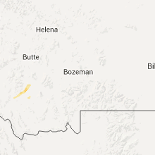
Montana
| Local Time | Report Details |
|---|---|
| 1:25 PM MDT | Quarter sized hail reported near Dillon, MT, 62.9 miles E of Salmon, ID, delayed report of quarter-size hail. time estimated via radar. |
| 2:30 PM MDT | Golf Ball sized hail reported near Plevna, MT, 64.8 miles E of Miles City, MT, trees are stripped of their leaves and broken windows in home. |
| 2:38 PM MDT | Golf Ball sized hail reported near Plevna, MT, 64.5 miles E of Miles City, MT |
| 3:00 PM MDT | Wind-driven golf ball sized hail broke out windows on west side of numerous homes in tow in fallon county MT, 75.1 miles E of Miles City, MT |
| 3:00 PM MDT | Golf Ball sized hail reported near Baker, MT, 75.1 miles E of Miles City, MT |
| 3:08 PM MDT | Half Dollar sized hail reported near Baker, MT, 74.2 miles E of Miles City, MT |
| 3:08 PM MDT | Storm damage reported in fallon county MT, 74.2 miles E of Miles City, MT |
| 3:10 PM MDT | Hen Egg sized hail reported near Baker, MT, 80.2 miles E of Miles City, MT, broken skylight. |
| 3:17 PM MDT | Storm damage reported in fallon county MT, 85.1 miles E of Miles City, MT |
| 3:17 PM MDT | Quarter sized hail reported near Baker, MT, 75.1 miles E of Miles City, MT |
| 3:30 PM MDT | Ping Pong Ball sized hail reported near Baker, MT, 84.1 miles E of Miles City, MT |
| 3:54 PM MDT | Quarter sized hail reported near Baker, MT, 88.7 miles ESE of Miles City, MT |
| 4:14 PM MDT | Hen Egg sized hail reported near Baker, MT, 80.2 miles E of Miles City, MT, broken skylight. |
| 7:00 PM MDT | Fishtail raws in stillwater county MT, 56.2 miles WSW of Billings, MT |
South Carolina
| Local Time | Report Details |
|---|---|
| 3:27 PM EDT | Sc highway patrol reports trees down at the intersection of n lake cherryvale dr and luton st near shaw afb in sumter... s in sumter county SC, 58.4 miles NNW of Charleston, SC |
| 3:28 PM EDT | Sc highway patrol reports trees down at the intersection of panola road and cody road near pinewood s in sumter county SC, 47.5 miles NNW of Charleston, SC |
| 3:50 PM EDT | Sc highway patrol reports multiple trees down in the vicinity of lakewood high school in sumter count in sumter county SC, 49.7 miles NNW of Charleston, SC |
| 4:00 PM EDT | Clarendon county dispatch reported powerlines down on bethel highwa in clarendon county SC, 43.7 miles NNW of Charleston, SC |
| 4:20 PM EDT | Clarendon county dispatch reported trees down at 1952 cecil mcfaddin road and around the alcolu are in clarendon county SC, 44 miles N of Charleston, SC |
| 4:27 PM EDT | Sc highway patrol reports a tree down on highway 269 near the richland county lin in fairfield county SC, 70.1 miles NE of Augusta, GA |
| 4:31 PM EDT | Lexington county dispatch reports a tree has fallen on a house on mapleview drive near irmo sc. there were no injuries reporte in lexington county SC, 61.3 miles NE of Augusta, GA |
| 4:32 PM EDT | Public reports tree down across st. john's road near shady grove road. picture relayed via social medi in richland county SC, 64 miles NE of Augusta, GA |
| 4:40 PM EDT | Sc highway patrol reports trees down near the intersection of i20 and broad river roa in richland county SC, 62.7 miles NE of Augusta, GA |
| 5:15 PM EDT | A tree was reportedly down on broomstraw road. the time was estimated based on radar dat in williamsburg county SC, 25.1 miles NNE of Charleston, SC |
| 7:05 PM EDT | Storm damage reported in horry county SC, 53.2 miles WSW of Wilmington, NC |
Illinois
| Local Time | Report Details |
|---|---|
| 3:12 PM CDT | Wind flattened a swath of corn near this location. estimated wind speeds of 50 mp in henderson county IL, 62.3 miles NE of Kahoka, MO |
| 3:30 PM CDT | Branches down including one on a power pole. time estimated by rada in warren county IL, 56.6 miles WNW of Peoria, IL |
| 3:35 PM CDT | Estmated 50 to 60 mph in warren county IL, 56.9 miles WNW of Peoria, IL |
| 3:35 PM CDT | Estmated 50 to 60 mph in warren county IL, 56.9 miles WNW of Peoria, IL |
| 4:06 PM CDT | On the north side of town in knox county IL, 45.2 miles WNW of Peoria, IL |
Missouri
| Local Time | Report Details |
|---|---|
| 3:28 PM CDT | A small tree that was 4 to 6 nches in diameter was snapped near the base. via facebook. time estimated using rada in clark county MO, 0.1 miles SSW of Kahoka, MO |
| 7:45 PM CDT | Large tree reported down in the city of forsyth in taney county MO, 37.7 miles SSE of Springfield, MO |
| 7:49 PM CDT | Ping Pong Ball sized hail reported near Forsyth, MO, 37.7 miles SSE of Springfield, MO, multiple reports of large hail in the forsyth area...including reports of half dollar to golf ball sized hail. |
| 7:52 PM CDT | Reports of trees down blocking highway 86 between highway 13 and highway j in stone county MO, 48 miles S of Springfield, MO |
Idaho
| Local Time | Report Details |
|---|---|
| 2:35 PM MDT | Storm damage reported in lincoln county ID, 37.8 miles NNE of Twin Falls, ID |
| 3:00 PM MDT | Storm damage reported in cassia county ID, 59.6 miles E of Twin Falls, ID |
| 3:00 PM MDT | Measured at tom cat summit itd sit in butte county ID, 72.7 miles NE of Twin Falls, ID |
| 3:20 PM MDT | Storm damage reported in butte county ID, 75.5 miles W of Idaho Falls, ID |
| 3:30 PM MDT | Storm damage reported in butte county ID, 51.9 miles W of Idaho Falls, ID |
| 3:30 PM MDT | Storm damage reported in butte county ID, 59 miles WSW of Idaho Falls, ID |
| 3:39 PM MDT | Moburg canyon raw in cassia county ID, 76.4 miles ESE of Twin Falls, ID |
| 3:45 PM MDT | Storm damage reported in butte county ID, 49.6 miles W of Idaho Falls, ID |
| 3:45 PM MDT | Storm damage reported in butte county ID, 42.6 miles W of Idaho Falls, ID |
| 3:45 PM MDT | Storm damage reported in butte county ID, 48.8 miles W of Idaho Falls, ID |
| 3:45 PM MDT | Storm damage reported in bingham county ID, 38.8 miles W of Idaho Falls, ID |
| 3:45 PM MDT | Arl station 11 ese butte cit in butte county ID, 50.7 miles W of Idaho Falls, ID |
| 3:45 PM MDT | Arl station 9 wnw atomic cit in butte county ID, 45.7 miles W of Idaho Falls, ID |
| 3:54 PM MDT | Potter butte raw in blaine county ID, 65.2 miles NE of Twin Falls, ID |
| 4:00 PM MDT | Storm damage reported in butte county ID, 47 miles W of Idaho Falls, ID |
| 4:00 PM MDT | Storm damage reported in butte county ID, 45.6 miles W of Idaho Falls, ID |
| 4:00 PM MDT | Storm damage reported in bingham county ID, 34.7 miles WSW of Idaho Falls, ID |
| 4:00 PM MDT | Storm damage reported in butte county ID, 44.9 miles WNW of Idaho Falls, ID |
| 4:05 PM MDT | Storm damage reported in bingham county ID, 31.3 miles WNW of Idaho Falls, ID |
| 4:05 PM MDT | Arl station 7 s how in butte county ID, 50.3 miles WNW of Idaho Falls, ID |
| 4:15 PM MDT | Storm damage reported in bonneville county ID, 15 miles WNW of Idaho Falls, ID |
| 4:15 PM MDT | Arl station sand dune in butte county ID, 41.1 miles WNW of Idaho Falls, ID |
| 4:15 PM MDT | Arl station 8 ssw mud lak in jefferson county ID, 29.1 miles WNW of Idaho Falls, ID |
| 4:25 PM MDT | Arl station critical infrastructure comple in butte county ID, 41.8 miles W of Idaho Falls, ID |
| 4:30 PM MDT | Arl station 1 ne terreto in jefferson county ID, 30.6 miles NW of Idaho Falls, ID |
| 4:30 PM MDT | Tree branches snapped off pine trees. time estimated from rada in bonneville county ID, 36.5 miles E of Idaho Falls, ID |
| 4:45 PM MDT | Storm damage reported in jefferson county ID, 37.1 miles NNW of Idaho Falls, ID |
South Dakota
| Local Time | Report Details |
|---|---|
| 4:50 PM MDT | Half Dollar sized hail reported near Belle Fourche, SD, 100.9 miles NNW of Rapid City, SD, hail ranged from pea size to ping pong ball |
| 6:50 PM MDT | Hen Egg sized hail reported near Bison, SD, 104.1 miles NNE of Rapid City, SD |
| 8:39 PM MDT | Storm damage reported in corson county SD, 66.3 miles S of Bismarck, ND |
| 10:29 PM CDT | Storm damage reported in walworth county SD, 81.6 miles N of Pierre, SD |
Texas
| Local Time | Report Details |
|---|---|
| 7:15 PM CDT | West texas mesonet in yoakum county TX, 62.1 miles WSW of Lubbock, TX |
| 7:25 PM CDT | West texas mesonet in yoakum county TX, 62.1 miles WSW of Lubbock, TX |
| 7:35 PM CDT | West texas mesonet in yoakum county TX, 62.1 miles WSW of Lubbock, TX |
Nebraska
| Local Time | Report Details |
|---|---|
| 7:57 PM MDT | Storm damage reported in dawes county NE, 75 miles NNE of Scottsbluff, NE |
| 8:21 PM MDT | Kings canyon raw in dawes county NE, 68.9 miles NNE of Scottsbluff, NE |
| 8:35 PM MDT | Storm damage reported in sheridan county NE, 83.9 miles NE of Scottsbluff, NE |
Minnesota
| Local Time | Report Details |
|---|---|
| 1:03 AM CDT | Meteorologist estimate in clay county MN, 3.2 miles SE of Fargo, ND |
| 1:35 AM CDT | Possible gust to 91 mph. measured by mobile anemometer. multiple large trees and branches broken down along hwy 1 in becker county MN, 30.4 miles E of Fargo, ND |
| 1:40 AM CDT | Peak wind measured at the rwis station along hwy 1 in becker county MN, 31.8 miles E of Fargo, ND |
| 3:30 AM CDT | 10 inch diameter tree down. time estimated from rada in crow wing county MN, 63.8 miles SSE of Bemidji, MN |
| 3:41 AM CDT | Brainerd raw in crow wing county MN, 82.2 miles SSE of Bemidji, MN |
| 3:46 AM CDT | Quarter sized hail reported near Brainerd, MN, 83.7 miles SSE of Bemidji, MN, . |
| 3:46 AM CDT | Ping Pong Ball sized hail reported near Brainerd, MN, 83.7 miles SSE of Bemidji, MN, . |
| 3:58 AM CDT | Quarter sized hail reported near Crosby, MN, 81.2 miles SSE of Bemidji, MN, . |
| 3:59 AM CDT | Ping Pong Ball sized hail reported near Crosby, MN, 80.7 miles SSE of Bemidji, MN, . |
| 4:00 AM CDT | Quarter sized hail reported near Crosby, MN, 80.9 miles SSE of Bemidji, MN, . |
Connect with Interactive Hail Maps