

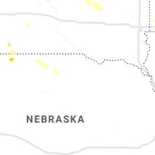
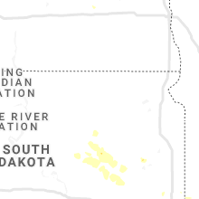
Hail Map for Saturday, July 13, 2019

Number of Impacted Households on 7/13/2019
0
Impacted by 1" or Larger Hail
0
Impacted by 1.75" or Larger Hail
0
Impacted by 2.5" or Larger Hail
Square Miles of Populated Area Impacted on 7/13/2019
0
Impacted by 1" or Larger Hail
0
Impacted by 1.75" or Larger Hail
0
Impacted by 2.5" or Larger Hail


Cities Most Affected by Hail Storms of 7/13/2019
| Hail Size | Demographics of Zip Codes Affected | ||||||
|---|---|---|---|---|---|---|---|
| City | Count | Average | Largest | Pop Density | House Value | Income | Age |
| Kenmare, ND | 1 | 1.75 | 1.75 | 2 | $43k | $30.4k | 46.6 |
Hail and Wind Damage Spotted on 7/13/2019
Filter by Report Type:Hail ReportsWind Reports
States Impacted
South Carolina, Alabama, Colorado, Montana, Georgia, South Dakota, North Dakota, Tennessee, Indiana, Mississippi, IllinoisSouth Carolina
| Local Time | Report Details |
|---|---|
| 2:24 PM EDT | Lancaster dispatch reported trees down on new hope rd west of heath springs. time estimated by rada in lancaster county SC, 43.5 miles S of Charlotte, NC |
| 3:05 PM EDT | Kershaw dispatch reported trees down and a power pole snapped with live wires blocking the road at community center rd and tombfield rd. time estimated by rada in kershaw county SC, 73.2 miles SSE of Charlotte, NC |
| 3:45 PM EDT | Fire dept/rescue reported a large tree down on power lines on hickory dr. time estimated from rada in spartanburg county SC, 29.2 miles ENE of Greenville, SC |
| 3:46 PM EDT | Report of tree blown down on cedar grove rd. time estimated from rada in union county SC, 48.9 miles E of Greenville, SC |
| 3:55 PM EDT | Fire dept/rescue reported a tree down on power lines on country club rd in spartanburg county SC, 40.4 miles E of Greenville, SC |
| 4:53 PM EDT | Fairfield dispatch reported powerlines down blocking the road on hwy 215 at cool branch rd. time estimated by rada in fairfield county SC, 55.7 miles SSW of Charlotte, NC |
| 4:53 PM EDT | Fairfield dispatch reported trees down on dave jenkins rd at hwy 215. time estimated by rada in fairfield county SC, 56.8 miles SSW of Charlotte, NC |
| 5:41 PM EDT | Large limbs and branches knocked down... a shed was destroyed and a metal carport was lifted and moved on mill creek road in vanc in orangeburg county SC, 28.9 miles NW of Charleston, SC |
| 6:09 PM EDT | Sc highway patrol reports a tree down on hallbrook dr at ronson st. time estimated by rada in richland county SC, 69.2 miles ENE of Augusta, GA |
| 6:10 PM EDT | Richland county reported trees down on leesburg rd at trotter rd. time estimated by rada in richland county SC, 71.7 miles ENE of Augusta, GA |
| 6:21 PM EDT | Schp reported a tree down at highway 78 and wish well dr likely due to a thunderstorm outflow boundar in dorchester county SC, 16.4 miles WSW of Charleston, SC |
| 7:05 PM EDT | Chesterfield co dispatch reported one tree down on society hill rd and bethel church rd. time estimate in chesterfield county SC, 68.8 miles SE of Charlotte, NC |
| 7:25 PM EDT | Orangeburg co dispatch reported 2 trees down at 207 jack branch rd. time estimate in orangeburg county SC, 32.6 miles WNW of Charleston, SC |
| 7:26 PM EDT | Schp reported a tree down at crestwood pl and kentwood circle likely due to a thunderstorm outflow boundar in charleston county SC, 33 miles S of Charleston, SC |
Alabama
| Local Time | Report Details |
|---|---|
| 3:04 PM CDT | Power lines down on rocky ford rd and elbert self rd in morgan county. time estimated based on rada in morgan county AL, 43.6 miles ESE of Florence, AL |
| 3:35 PM CDT | Mesonet station uss alabama (pinto island) measured a wind gust of 72 mp in gmz630 county AL, 2.6 miles E of Mobile, AL |
| 3:44 PM CDT | Mesonet station ew6967 mobile (cooper park) measured a wind gust of 68 mp in mobile county AL, 0.8 miles ENE of Mobile, AL |
Colorado
| Local Time | Report Details |
|---|---|
| 2:48 PM MDT | Asos station kmtj montrose rgnl airpor in montrose county CO, 53.1 miles SE of Grand Junction, CO |
| 3:25 PM MDT | Tree blown over onto ca in montrose county CO, 55.3 miles SE of Grand Junction, CO |
| 7:17 PM MDT | Quarter sized hail reported near Broomfield, CO, 13.9 miles N of Denver, CO |
Montana
| Local Time | Report Details |
|---|---|
| 2:53 PM MDT | Quarter sized hail reported near , , 31.3 miles NW of Great Falls, MT |
| 3:00 PM MDT | Mesonet station drlm deer lodg in powell county MT, 69 miles ESE of Missoula, MT |
| 3:40 PM MDT | Macdonald pass dot senso in powell county MT, 81.1 miles SW of Great Falls, MT |
| 3:50 PM MDT | Quarter sized hail reported near Bonner, MT, 9.2 miles ENE of Missoula, MT |
| 4:10 PM MDT | 6.5 per hour rain rates in stillwater county MT, 30.9 miles WSW of Billings, MT |
| 4:15 PM MDT | Quarter sized hail reported near Columbus, MT, 36.9 miles WSW of Billings, MT |
| 4:27 PM MDT | Corrects previous tstm wnd gst time report from 2 sw lewistow in fergus county MT, 92.3 miles ESE of Great Falls, MT |
| 4:30 PM MDT | Pea-sized hail. 1-1.5 inch tree limbs broke in stillwater county MT, 22.7 miles WSW of Billings, MT |
| 4:33 PM MDT | Brief heavy rainfall of 0.43 inches in 13 minutes with pea sized hail... 27 mph wind gusts... and lots of lightning. second hand report of branches knocked down - repor in fergus county MT, 94.2 miles ESE of Great Falls, MT |
| 4:34 PM MDT | Quarter sized hail reported near Lewistown, MT, 93.6 miles ESE of Great Falls, MT |
| 4:37 PM MDT | Storm damage reported in fergus county MT, 92.3 miles ESE of Great Falls, MT |
| 4:52 PM MDT | Mesonet station jpkm8 judith peak raw in fergus county MT, 94.4 miles SSE of Havre, MT |
| 5:05 PM MDT | Wind gust of 58 mp in yellowstone county MT, 6.3 miles SE of Billings, MT |
| 5:52 PM MDT | Manning corral dogtown location. time estimated from rada in phillips county MT, 80.7 miles SE of Havre, MT |
| 5:52 PM MDT | Time estimated from rada in phillips county MT, 71.4 miles SE of Havre, MT |
| 6:18 PM MDT | Mesonet station fblm8 fort belknap raw in blaine county MT, 47.1 miles ESE of Havre, MT |
| 6:30 PM MDT | Malta south us-191 mile post 122.5 dot sit in phillips county MT, 75 miles ESE of Havre, MT |
| 6:46 PM MDT | A lot of dirt was kicked up... birds were caught in the wind... and entire trees were waving in the win in valley county MT, 41.1 miles SW of Glasgow, MT |
| 6:52 PM MDT | Time estimated from rada in phillips county MT, 71.4 miles SE of Havre, MT |
| 7:18 PM MDT | King coulee raws site. time estimated from rada in valley county MT, 32.6 miles SSW of Glasgow, MT |
| 7:54 PM MDT | Davis weather statio in valley county MT, 1.8 miles NNW of Glasgow, MT |
| 8:00 PM MDT | Saint marie marco sit in valley county MT, 15.8 miles NNE of Glasgow, MT |
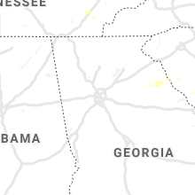
Georgia
| Local Time | Report Details |
|---|---|
| 5:04 PM EDT | Tree down on lexington hw in elbert county GA, 57.2 miles SSW of Greenville, SC |
| 5:06 PM EDT | Tree down on car with minor damage on elbert s in elbert county GA, 52.4 miles SSW of Greenville, SC |
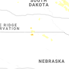
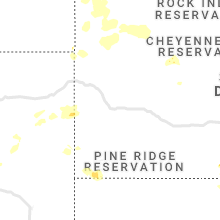
South Dakota
| Local Time | Report Details |
|---|---|
| 5:35 PM CDT | Estimated 60-65 mph wind gusts. cottonwood trees bending at 45 degree angle... branches dow in hand county SD, 56.2 miles SSW of Aberdeen, SD |
| 5:45 PM CDT | 2 inch tree branches down... nickle size hai in hand county SD, 55.6 miles SSW of Aberdeen, SD |
| 5:45 PM CDT | Estimated 60-70mph winds. near 0 visibility with blowing rain... branches dow in spink county SD, 51.7 miles S of Aberdeen, SD |
| 6:10 PM CDT | Quarter sized hail reported near Hitchcock, SD, 59.3 miles S of Aberdeen, SD, little hail... but was nickel to quarter size. |
| 6:13 PM CDT | Several 6 to 12 inch diameter limbs removed from mature tree in beadle county SD, 66.2 miles S of Aberdeen, SD |
| 6:39 PM CDT | Storm damage reported in beadle county SD, 76.3 miles S of Aberdeen, SD |
| 6:45 PM CDT | Several trees limbs and a few trees down across tow in beadle county SD, 77 miles S of Aberdeen, SD |
| 11:52 PM MDT | Storm damage reported in harding county SD, 106 miles N of Rapid City, SD |
North Dakota
| Local Time | Report Details |
|---|---|
| 6:15 PM CDT | Golf Ball sized hail reported near Kenmare, ND, 57.5 miles NW of Minot, ND |
| 6:46 PM CDT | Ping Pong Ball sized hail reported near Kenmare, ND, 49.7 miles NW of Minot, ND |
| 12:30 AM MDT | Storm damage reported in harding county SD, 123.5 miles WSW of Bismarck, ND |
Tennessee
| Local Time | Report Details |
|---|---|
| 7:45 PM CDT | A few reports of trees down blocking roads and power outages across southeast putnam county in putnam county TN, 72.7 miles N of Chattanooga, TN |
| 8:59 PM CDT | Large tree branches blocking judge austin road just west of spart in white county TN, 62 miles N of Chattanooga, TN |
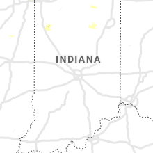
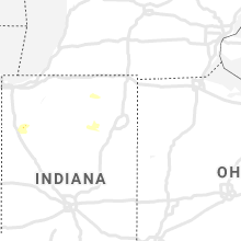
Indiana
| Local Time | Report Details |
|---|---|
| 8:09 PM CDT | Corrects previous updated of tstm wnd gst report from munster. three large tree limbs down blocking roadways in munste in lake county IN, 24.1 miles SSE of Chicago, IL |
| 8:10 PM CDT | Large tree limb down. relayed via social medi in lake county IN, 24.1 miles SSE of Chicago, IL |
| 8:22 PM CDT | Delayed report. large tree limb snapped. report relayed via social media by broadcast media and trained spotte in lake county IN, 26.6 miles SSE of Chicago, IL |
| 1:47 AM CDT | Quarter sized hail reported near Rensselaer, IN, 69.8 miles SSE of Chicago, IL, along rt. 231. |
Mississippi
| Local Time | Report Details |
|---|---|
| 4:30 AM CDT | Tree debris and downed power lines on us 11 at seneca r in lamar county MS, 83.9 miles NNE of New Orleans, LA |
Illinois
| Local Time | Report Details |
|---|---|
| 4:54 AM CDT | Quarter sized hail reported near Chatsworth, IL, 68.2 miles E of Peoria, IL |
Connect with Interactive Hail Maps