

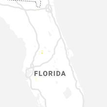
Hail Map for Tuesday, July 16, 2019

Number of Impacted Households on 7/16/2019
0
Impacted by 1" or Larger Hail
0
Impacted by 1.75" or Larger Hail
0
Impacted by 2.5" or Larger Hail
Square Miles of Populated Area Impacted on 7/16/2019
0
Impacted by 1" or Larger Hail
0
Impacted by 1.75" or Larger Hail
0
Impacted by 2.5" or Larger Hail


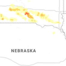


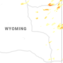


Cities Most Affected by Hail Storms of 7/16/2019
| Hail Size | Demographics of Zip Codes Affected | ||||||
|---|---|---|---|---|---|---|---|
| City | Count | Average | Largest | Pop Density | House Value | Income | Age |
| Hosmer, SD | 2 | 1.88 | 2.00 | 1 | $16k | $26.8k | 54.0 |
| Mc Laughlin, SD | 2 | 1.75 | 1.75 | 1 | $27k | $20.4k | 28.2 |
| Moorcroft, WY | 1 | 3.00 | 3.00 | 2 | $86k | $42.3k | 37.7 |
| Spearfish, SD | 1 | 1.75 | 1.75 | 62 | $98k | $30.2k | 38.6 |
| Gillette, WY | 1 | 1.75 | 1.75 | 13 | $113k | $55.4k | 31.2 |
| Broadus, MT | 1 | 1.75 | 1.75 | 0 | $58k | $27.8k | 49.9 |
| Regent, ND | 1 | 1.75 | 1.75 | 1 | $20k | $30.5k | 49.3 |
| Ipswich, SD | 1 | 1.75 | 1.75 | 3 | $47k | $32.0k | 45.6 |
| Little Eagle, SD | 1 | 1.75 | 1.75 | 0 | $0k | $0.0k | 21.1 |
| Mc Intosh, SD | 1 | 1.75 | 1.75 | 0 | $12k | $25.8k | 49.3 |
Hail and Wind Damage Spotted on 7/16/2019
Filter by Report Type:Hail ReportsWind Reports
States Impacted
Iowa, Mississippi, North Carolina, New York, Montana, Ohio, Oklahoma, Indiana, Virginia, South Dakota, Kentucky, Nebraska, Wyoming, Pennsylvania, North Dakota, ColoradoIowa
| Local Time | Report Details |
|---|---|
| 11:03 AM CDT | Asos station kest estherville airpor in emmet county IA, 56.8 miles NNE of Storm Lake, IA |
Mississippi
| Local Time | Report Details |
|---|---|
| 1:03 PM CDT | Minor damage to the roof of a metal building and tree limbs down in chalybeate communit in tippah county MS, 68.5 miles W of Florence, AL |
| 5:00 PM CDT | Corrects previous tstm wnd dmg report from louisville. trees were down in the city and on highway 14. likely sub severe wind gust in winston county MS, 27.5 miles SSW of Starkville, MS |
North Carolina
| Local Time | Report Details |
|---|---|
| 2:33 PM EDT | 2-3 trees down in oak park community due to suspected downburs in wake county NC, 5.8 miles NW of Raleigh, NC |
| 6:45 PM EDT | A few power lines and trees down/snapped near j kenneth hall road and research farm road in the community of hugo. time estimated by rada in lenoir county NC, 67.6 miles ESE of Raleigh, NC |
| 7:18 PM EDT | Trees blown down near intersection of jack jones rd and old tar r in pitt county NC, 73.6 miles ESE of Raleigh, NC |
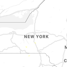
New York
| Local Time | Report Details |
|---|---|
| 3:13 PM EDT | Multiple trees down and tents collapsed in emerson park. time estimated from rada in cayuga county NY, 22 miles WSW of Syracuse, NY |
| 5:21 PM EDT | Trees and wires down near 1920 county route 1 in schuyler county NY, 59.2 miles SSW of Syracuse, NY |
| 5:49 PM EDT | Trees dow in tompkins county NY, 42.2 miles SSW of Syracuse, NY |
| 6:00 PM EDT | Trees dow in tompkins county NY, 39.1 miles SSW of Syracuse, NY |
| 6:08 PM EDT | Multiple reports of trees down in cortland are in cortland county NY, 31.1 miles S of Syracuse, NY |
| 6:15 PM EDT | Multiple tree limbs down on carr hill roa in cortland county NY, 31.1 miles S of Syracuse, NY |
| 6:22 PM EDT | Trees and wires down on west river road near snyder hill roa in cortland county NY, 34.6 miles S of Syracuse, NY |
| 8:10 PM EDT | 15-20 trees down on hickory hill rd. likely microburs in montgomery county NY, 25.2 miles WNW of Schenectady, NY |
| 8:11 PM EDT | Two trees down broadway and par in montgomery county NY, 24.2 miles WNW of Schenectady, NY |
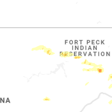
Montana
| Local Time | Report Details |
|---|---|
| 1:45 PM MDT | Public reported about 2 dozen large trees down at the koa near west yellowstone. some tents blown away. some awnings destroyed. wind speeds and time of event are estima in gallatin county MT, 68.9 miles S of Bozeman, MT |
| 3:42 PM MDT | Ping Pong Ball sized hail reported near , , 43 miles SE of Billings, MT, 1-1.5 inch hail. heavy rain. |
| 3:47 PM MDT | Ping Pong Ball sized hail reported near Fort Smith, MT, 42.7 miles SE of Billings, MT |
| 4:24 PM MDT | Grain bin was damaged due to wind in valley county MT, 13.9 miles E of Glasgow, MT |
| 6:15 PM MDT | Quarter sized hail reported near Cardwell, MT, 47.9 miles WNW of Bozeman, MT, quarter size hail falling. |
| 6:15 PM MDT | Golf Ball sized hail reported near Broadus, MT, 62.4 miles N of Gillette, WY |
| 6:16 PM MDT | Quarter sized hail reported near Cardwell, MT, 47.9 miles WNW of Bozeman, MT, quarter size hail still falling. ground is being covered by hail. |
| 6:51 PM MDT | Quarter sized hail reported near Poplar, MT, 68.5 miles WSW of Williston, ND, high wall cloud with a little rotation also observed. |
| 7:39 PM MDT | Quarter sized hail reported near Whitehall, MT, 68.1 miles W of Bozeman, MT, quarter size hail falling. |
| 7:40 PM MDT | Quarter sized hail reported near Whitehall, MT, 67.6 miles W of Bozeman, MT, quarter size hail still falling. the amount of quarter size falling is increasing. highway 2 in this area is being affected. |
| 7:58 PM MDT | Storm damage reported in richland county MT, 58.1 miles SW of Williston, ND |
| 8:32 PM MDT | Storm damage reported in dawson county MT, 70.1 miles SW of Williston, ND |
Ohio
| Local Time | Report Details |
|---|---|
| 3:53 PM EDT | Large branch blown onto roof of house. time estimated from rada in montgomery county OH, 41.7 miles NNE of Cincinnati, OH |
| 4:08 PM EDT | Several 3 to 5 inch tree branches blown down. time estimated from radar dat in montgomery county OH, 54.7 miles NNE of Cincinnati, OH |
| 5:00 PM EDT | A tree was downed near the intersection of county road 1 and township road 30. time estimated from rada in logan county OH, 44.7 miles WNW of Columbus, OH |
| 5:30 PM EDT | A tree was downed onto osborne road near state route 739. time estimated by rada in union county OH, 41.7 miles NNW of Columbus, OH |
| 5:55 PM EDT | A couple of trees were downe in scioto county OH, 73.4 miles WNW of Charleston, WV |
| 6:07 PM EDT | Seneca county sheriff dispatch reports one tree downed in seneca townshi in seneca county OH, 74.7 miles N of Columbus, OH |
| 6:35 PM EDT | Social media report of a downed tree on 2nd street in shelb in richland county OH, 65.9 miles NNE of Columbus, OH |
| 6:55 PM EDT | Large tree branch reported in roa in richland county OH, 61.2 miles SW of Cleveland, OH |
| 8:44 PM EDT | Power lines reported dow in noble county OH, 81.2 miles E of Columbus, OH |
| 8:48 PM EDT | Large tree limbs reported on or and w tunnel roa in noble county OH, 82.5 miles E of Columbus, OH |
Oklahoma
| Local Time | Report Details |
|---|---|
| 3:30 PM CDT | Tree damage. up to 3 in diameter tree limbs broke in kay county OK, 52.9 miles S of Wichita, KS |
| 3:55 PM CDT | Minor damage to roof of a fertilizer storage unit. relayed by kfor stormtracke in kay county OK, 59.8 miles S of Wichita, KS |
| 4:25 PM CDT | Some tree damag in kay county OK, 66.1 miles SSE of Wichita, KS |
Indiana
| Local Time | Report Details |
|---|---|
| 4:48 PM EDT | A tree and power lines were downed on niewoehner road between locust grove road and wolfe roa in wayne county IN, 49.4 miles NNW of Cincinnati, OH |
Virginia
| Local Time | Report Details |
|---|---|
| 5:30 PM EDT | Tree down on route in lancaster county VA, 64.4 miles NNW of Virginia Beach, VA |
| 5:40 PM EDT | Trees down near toppin in middlesex county VA, 61.9 miles NNW of Virginia Beach, VA |
South Dakota
| Local Time | Report Details |
|---|---|
| 3:36 PM MDT | Quarter sized hail reported near , , 11 miles NW of Rapid City, SD |
| 4:42 PM MDT | Golf Ball sized hail reported near Mc Laughlin, SD, 71.9 miles S of Bismarck, ND, strong winds that took down lots of small tree branches were also observed. |
| 5:16 PM MDT | Golf Ball sized hail reported near Mc Laughlin, SD, 76.5 miles S of Bismarck, ND, lots of smaller hail with a few larger stones up to golf ball sized mixed in. |
| 6:24 PM CDT | Quarter sized hail reported near Eureka, SD, 65.6 miles WNW of Aberdeen, SD, a few quarters with estimated winds up to 50 mph hour. |
| 5:35 PM MDT | Quarter sized hail reported near Wakpala, SD, 79.9 miles S of Bismarck, ND, lots of hail covering the ground. |
| 6:55 PM CDT | Golf Ball sized hail reported near Hosmer, SD, 52.5 miles W of Aberdeen, SD, ground covered in hail as large as golf balls. |
| 7:00 PM CDT | Ping Pong Ball sized hail reported near Hosmer, SD, 48.4 miles W of Aberdeen, SD, report relayed via social media. |
| 7:08 PM CDT | Hen Egg sized hail reported near Hosmer, SD, 48.4 miles W of Aberdeen, SD, photo relayed via social media. radar estimated time. |
| 6:16 PM MDT | Storm damage reported in fall river county SD, 66.9 miles SW of Rapid City, SD |
| 7:20 PM CDT | Half Dollar sized hail reported near Glenham, SD, 82.7 miles W of Aberdeen, SD, quarter to half dollar. |
| 7:20 PM CDT | Quarter sized hail reported near Hosmer, SD, 46.8 miles W of Aberdeen, SD |
| 7:58 PM CDT | Quarter sized hail reported near Roscoe, SD, 34.2 miles W of Aberdeen, SD |
| 7:00 PM MDT | Rain fell in 20 minutes in custer county SD, 41.8 miles SW of Rapid City, SD |
| 7:17 PM MDT | Quarter sized hail reported near Watauga, SD, 66.7 miles SW of Bismarck, ND, quarter sized hail. |
| 8:29 PM CDT | Golf Ball sized hail reported near Ipswich, SD, 29.6 miles WSW of Aberdeen, SD |
| 7:44 PM MDT | Golf Ball sized hail reported near Mc Intosh, SD, 66.7 miles SSW of Bismarck, ND, a few golf ball sized hailstones mixed in with smaller hail. winds estimated at 40 to 50 mph. |
| 8:49 PM CDT | Quarter sized hail reported near Ipswich, SD, 31.8 miles WSW of Aberdeen, SD |
| 8:00 PM MDT | Golf Ball sized hail reported near Spearfish, SD, 41.2 miles NW of Rapid City, SD |
| 8:31 PM MDT | Quarter sized hail reported near Mc Laughlin, SD, 71.9 miles S of Bismarck, ND, hailed for about 15 minutes. |
| 8:35 PM MDT | Storm damage reported in oglala lakota county SD, 85 miles W of Valentine, NE |
| 8:35 PM MDT | Storm damage reported in oglala lakota county SD, 85.5 miles W of Valentine, NE |
| 8:44 PM MDT | Golf Ball sized hail reported near Little Eagle, SD, 76.4 miles S of Bismarck, ND, report referred via the mobridge police department. |
| 8:59 PM MDT | Storm damage reported in jackson county SD, 69.1 miles NW of Valentine, NE |
| 9:05 PM MDT | Storm damage reported in jackson county SD, 69.1 miles NW of Valentine, NE |
| 10:27 PM CDT | Ping Pong Ball sized hail reported near Mobridge, SD, 81 miles N of Pierre, SD |
| 9:29 PM MDT | Storm damage reported in jackson county SD, 49.4 miles SW of Pierre, SD |
| 10:50 PM CDT | Storm damage reported in jones county SD, 42.7 miles SW of Pierre, SD |
| 10:45 PM MDT | Quarter sized hail reported near Rapid City, SD, 2.2 miles SSE of Rapid City, SD |
| 1:09 AM CDT | Storm damage reported in buffalo county SD, 70.4 miles ESE of Pierre, SD |
| 1:10 AM CDT | Time estimated by radar. 141 am observation of 73 mph... which occurred during the previous hou in hand county SD, 78.8 miles E of Pierre, SD |
| 4:16 AM CDT | Storm damage reported in brule county SD, 81.7 miles ESE of Pierre, SD |
| 4:25 AM CDT | Storm damage reported in charles mix county SD, 57.9 miles N of Oneill, NE |
| 5:06 AM CDT | Large picnic table blown ove in charles mix county SD, 42 miles N of Oneill, NE |
| 5:08 AM CDT | Storm damage reported in douglas county SD, 60.2 miles NNE of Oneill, NE |
| 5:33 AM CDT | Storm damage reported in hutchinson county SD, 64.3 miles W of Sioux Falls, SD |
| 5:53 AM CDT | Storm damage reported in hutchinson county SD, 45.8 miles WSW of Sioux Falls, SD |
Kentucky
| Local Time | Report Details |
|---|---|
| 4:50 PM CDT | Two trees were reported down in adairvill in logan county KY, 34.9 miles N of Nashville, TN |
| 9:05 PM EDT | Dispatch reported a tree down on mount zion road in crestwoo in oldham county KY, 26.9 miles NE of Louisville, KY |
Nebraska
| Local Time | Report Details |
|---|---|
| 5:02 PM MDT | Quarter sized hail reported near Bayard, NE, 13 miles SE of Scottsbluff, NE, state highway 92. |
| 5:34 PM MDT | Quarter sized hail reported near Bayard, NE, 21.6 miles E of Scottsbluff, NE |
Wyoming
| Local Time | Report Details |
|---|---|
| 5:37 PM MDT | Quarter sized hail reported near Lusk, WY, 81.5 miles SSW of Rapid City, SD |
| 7:32 PM MDT | Quarter sized hail reported near Weston, WY, 42.4 miles N of Gillette, WY |
| 7:40 PM MDT | Quarter sized hail reported near Sundance, WY, 55 miles WNW of Rapid City, SD |
| 7:52 PM MDT | Tea Cup sized hail reported near Moorcroft, WY, 27.6 miles E of Gillette, WY |
| 8:00 PM MDT | Ping Pong Ball sized hail reported near Moorcroft, WY, 28.5 miles E of Gillette, WY |
| 8:05 PM MDT | Quarter sized hail reported near Beulah, WY, 52.3 miles NW of Rapid City, SD |
| 8:05 PM MDT | Storm damage reported in crook county WY, 52.3 miles NW of Rapid City, SD |
| 8:05 PM MDT | Golf Ball sized hail reported near Gillette, WY, 20.1 miles SSE of Gillette, WY |
| 8:05 PM MDT | Storm damage reported in crook county WY, 45.2 miles ENE of Gillette, WY |
| 8:43 PM MDT | Quarter sized hail reported near Sheridan, WY, 82.8 miles WNW of Gillette, WY, 1 inch hail found after the storm moved through. |
| 9:43 PM MDT | Quarter sized hail reported near Sheridan, WY, 82.8 miles WNW of Gillette, WY, 1 inch hail found after the storm moved through. time from radar. |
Pennsylvania
| Local Time | Report Details |
|---|---|
| 7:50 PM EDT | Trees and wires down. time estimated from rada in cumberland county PA, 60.2 miles SE of State College, PA |
North Dakota
| Local Time | Report Details |
|---|---|
| 8:18 PM MDT | Golf Ball sized hail reported near Regent, ND, 84 miles WSW of Bismarck, ND, golf ball sized hail. |
| 9:17 PM MDT | Quarter sized hail reported near Mott, ND, 79.7 miles WSW of Bismarck, ND, gusty winds and street flooding also ongoing. |
Colorado
| Local Time | Report Details |
|---|---|
| 10:45 PM MDT | Temperature is currently rising and dewpoint is fallin in cheyenne county CO, 79.4 miles SSW of Yuma, CO |
Connect with Interactive Hail Maps