

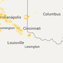
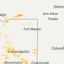
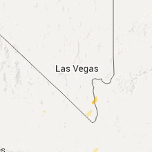
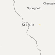
Hail Map for Friday, July 17, 2015

Number of Impacted Households on 7/17/2015
0
Impacted by 1" or Larger Hail
0
Impacted by 1.75" or Larger Hail
0
Impacted by 2.5" or Larger Hail
Square Miles of Populated Area Impacted on 7/17/2015
0
Impacted by 1" or Larger Hail
0
Impacted by 1.75" or Larger Hail
0
Impacted by 2.5" or Larger Hail


Cities Most Affected by Hail Storms of 7/17/2015
| Hail Size | Demographics of Zip Codes Affected | ||||||
|---|---|---|---|---|---|---|---|
| City | Count | Average | Largest | Pop Density | House Value | Income | Age |
| Britton, SD | 10 | 2.15 | 3.00 | 2 | $46k | $32.2k | 44.9 |
| Leola, SD | 6 | 2.54 | 2.75 | 1 | $20k | $23.8k | 42.5 |
| Beardsley, MN | 2 | 2.38 | 2.75 | 3 | $23k | $30.1k | 50.1 |
| Sutherland, NE | 2 | 1.88 | 2.00 | 3 | $74k | $38.9k | 40.6 |
| Lake City, SD | 2 | 1.88 | 2.00 | 4 | $55k | $33.8k | 54.4 |
| Maxwell, NE | 1 | 3.00 | 3.00 | 1 | $52k | $32.3k | 41.6 |
| Stapleton, NE | 1 | 2.75 | 2.75 | 1 | $53k | $33.9k | 45.0 |
| Amenia, ND | 1 | 2.50 | 2.50 | 4 | $58k | $40.3k | 44.0 |
| Pierce, NE | 1 | 2.00 | 2.00 | 15 | $69k | $36.7k | 40.9 |
| Summit, SD | 1 | 2.00 | 2.00 | 3 | $24k | $26.8k | 37.1 |
| Wallace, SD | 1 | 1.75 | 1.75 | 2 | $29k | $20.0k | 35.8 |
| Webster, SD | 1 | 1.75 | 1.75 | 7 | $41k | $33.4k | 47.3 |
| Westport, SD | 1 | 1.75 | 1.75 | 2 | $45k | $33.0k | 37.5 |
| Larned, KS | 1 | 1.75 | 1.75 | 16 | $52k | $34.2k | 42.2 |
| Valley City, ND | 1 | 1.75 | 1.75 | 24 | $65k | $30.6k | 43.1 |
| Browns Valley, MN | 1 | 1.75 | 1.75 | 8 | $23k | $25.6k | 47.2 |
| Sisseton, SD | 1 | 1.75 | 1.75 | 13 | $48k | $27.9k | 34.1 |
| Frederick, SD | 1 | 1.75 | 1.75 | 1 | $40k | $32.5k | 44.1 |
| Groton, SD | 1 | 1.75 | 1.75 | 6 | $72k | $38.0k | 41.0 |
| Henry, SD | 1 | 1.75 | 1.75 | 4 | $46k | $36.9k | 43.5 |
Hail and Wind Damage Spotted on 7/17/2015
Filter by Report Type:Hail ReportsWind Reports
States Impacted
Indiana, Illinois, Florida, Texas, South Dakota, Alabama, Nebraska, Wyoming, Kansas, North Dakota, Georgia, Kentucky, Minnesota, Arizona, California, Michigan, Utah, Iowa, Nevada, WisconsinIndiana
| Local Time | Report Details |
|---|---|
| 3:45 PM EDT | Quarter sized hail reported near Lynn, IN, 67.2 miles ENE of Indianapolis, IN, relayed from amateur radio from their social media webpage |
| 4:04 PM EDT | Minor tree limbs down in tippecanoe county IN, 58.8 miles NW of Indianapolis, IN |
| 4:18 PM EDT | Quarter sized hail reported near Greens Fork, IN, 59.1 miles E of Indianapolis, IN, shave report. |
| 4:33 PM EDT | Quarter sized hail reported near Richmond, IN, 58.7 miles NNW of Cincinnati, OH, shave report. |
| 4:52 PM EDT | Quarter sized hail reported near Richmond, IN, 55 miles NNW of Cincinnati, OH, shave report. |
| 4:54 PM EDT | Quarter sized hail reported near Richmond, IN, 54 miles NNW of Cincinnati, OH, west side of richmond |
| 4:55 PM EDT | One large tree down blocking woodstock drive. numerous other trees snapped in half as well as uprooted throughout brownsbur in hendricks county IN, 13.7 miles WNW of Indianapolis, IN |
| 5:52 PM EDT | Trees or limbs down. time estimated from rada in decatur county IN, 41.1 miles SE of Indianapolis, IN |
| 6:00 PM EDT | Between 2.00 and 2.24 inches of rain in the last 40 minutes. many large tree branches down...some across road and downing power lines. significant ponding of wate in boone county IN, 28.9 miles NW of Indianapolis, IN |
| 6:16 PM EDT | Storm damage reported in parke county IN, 57.7 miles ENE of Mattoon, IL |
| 6:16 PM EDT | Tree fell on a pickup truck. time estimated from rada in decatur county IN, 50.7 miles W of Cincinnati, OH |
| 6:25 PM EDT | One large tree downed near the intersection of old michigan road and w 650 in ripley county IN, 45.1 miles W of Cincinnati, OH |
| 6:30 PM EDT | Storm damage reported in hendricks county IN, 17.9 miles WSW of Indianapolis, IN |
| 6:30 PM EDT | Numerous trees down along route 3. time estimate in decatur county IN, 48.6 miles SE of Indianapolis, IN |
| 6:30 PM EDT | *** 2 inj *** tree down on vehicle... near 500s and 20w. time estimate in decatur county IN, 49.6 miles SE of Indianapolis, IN |
| 6:32 PM EDT | Multiple trees down blocking the road near jac-cen-del high schoo in ripley county IN, 42.3 miles W of Cincinnati, OH |
| 6:33 PM EDT | Numerous trees downed along us route 421 between osgood and versaille in ripley county IN, 41.7 miles W of Cincinnati, OH |
| 6:34 PM EDT | Damage to a car port on hasmer hill roa in ripley county IN, 40.6 miles W of Cincinnati, OH |
| 6:42 PM EDT | Numerous 4-6 inch trees down. standing water on highway 5 in ripley county IN, 48.8 miles W of Cincinnati, OH |
| 9:30 PM EDT | Trees down and shingle damage to roof in jefferson county IN, 52.3 miles NNE of Louisville, KY |
| 10:24 PM EDT | Tree dow in floyd county IN, 22.4 miles NNW of Louisville, KY |
| 10:28 PM EDT | Trees reported dow in floyd county IN, 24.4 miles NNW of Louisville, KY |
| 10:30 PM EDT | Large tree limbs dow in clark county IN, 23.8 miles N of Louisville, KY |
Illinois
| Local Time | Report Details |
|---|---|
| 3:40 PM CDT | 6+ inch diameter tree limbs dow in winnebago county IL, 52.3 miles SSE of Madison, WI |
| 3:45 PM CDT | Quarter sized hail reported near Loves Park, IL, 54.1 miles SSE of Madison, WI, off duty faa weather observer posted pic to nws chicago facebook |
| 4:03 PM CDT | Quarter sized hail reported near Machesney Park, IL, 51.6 miles SSE of Madison, WI |
| 5:07 PM CDT | Quarter sized hail reported near Algonquin, IL, 37.3 miles WNW of Chicago, IL |
| 5:28 PM CDT | Quarter sized hail reported near Elgin, IL, 32.9 miles WNW of Chicago, IL |
| 5:30 PM CDT | Quarter sized hail reported near Hoffman Estates, IL, 28.8 miles WNW of Chicago, IL |
Florida
| Local Time | Report Details |
|---|---|
| 4:45 PM EDT | Tree down on porch on ne 20th stree in alachua county FL, 61.3 miles SW of Jacksonville, FL |
Texas
| Local Time | Report Details |
|---|---|
| 3:57 PM CDT | Storm damage reported in deaf smith county TX, 27.3 miles SW of Amarillo, TX |
| 4:22 PM CDT | Report relayed by broadcast media of tree and power pole damage from the intersections of helium road and rockwell road to the intersection of soncy and fm 2219. time e in randall county TX, 13.3 miles SSW of Amarillo, TX |
| 4:26 PM CDT | Storm damage reported in randall county TX, 10.2 miles SSW of Amarillo, TX |
| 4:39 PM CDT | Storm damage reported in randall county TX, 7 miles SSE of Amarillo, TX |
| 8:13 PM CDT | Storm damage reported in potter county TX, 12.3 miles W of Amarillo, TX |
| 8:15 PM CDT | Storm damage reported in potter county TX, 10 miles W of Amarillo, TX |
| 8:28 PM CDT | Storm damage reported in potter county TX, 10 miles W of Amarillo, TX |
| 8:31 PM CDT | Storm damage reported in potter county TX, 12.3 miles W of Amarillo, TX |
South Dakota
| Local Time | Report Details |
|---|---|
| 3:09 PM MDT | Storm damage reported in pennington county SD, 29.3 miles WSW of Rapid City, SD |
| 4:49 PM CDT | Quarter sized hail reported near Britton, SD, 42.4 miles ENE of Aberdeen, SD |
| 4:55 PM CDT | Golf Ball sized hail reported near Britton, SD, 42 miles ENE of Aberdeen, SD |
| 4:55 PM CDT | Golf Ball sized hail reported near Britton, SD, 41.8 miles ENE of Aberdeen, SD |
| 4:56 PM CDT | Ping Pong Ball sized hail reported near Britton, SD, 42.4 miles ENE of Aberdeen, SD, estimated wind gusts around 40 mph |
| 4:58 PM CDT | Tennis Ball sized hail reported near Britton, SD, 42.4 miles ENE of Aberdeen, SD |
| 4:58 PM CDT | Storm chaser also reports no electricity in town in marshall county SD, 42.4 miles ENE of Aberdeen, SD |
| 4:58 PM CDT | Hen Egg sized hail reported near Britton, SD, 44 miles ENE of Aberdeen, SD |
| 5:03 PM CDT | Tennis Ball sized hail reported near Britton, SD, 46.3 miles NE of Aberdeen, SD |
| 5:06 PM CDT | Golf Ball sized hail reported near Britton, SD, 46.4 miles ENE of Aberdeen, SD |
| 5:06 PM CDT | Hen Egg sized hail reported near Britton, SD, 48.7 miles ENE of Aberdeen, SD |
| 5:11 PM CDT | Ping Pong Ball sized hail reported near Britton, SD, 49.1 miles ENE of Aberdeen, SD |
| 5:16 PM CDT | Tennis Ball sized hail reported near Britton, SD, 47.7 miles ENE of Aberdeen, SD |
| 5:19 PM CDT | Hen Egg sized hail reported near Leola, SD, 31.1 miles NW of Aberdeen, SD |
| 5:21 PM CDT | Tennis Ball sized hail reported near Leola, SD, 31.6 miles NW of Aberdeen, SD |
| 5:24 PM CDT | Baseball sized hail reported near Leola, SD, 28.4 miles NW of Aberdeen, SD |
| 5:30 PM CDT | Baseball sized hail reported near Leola, SD, 28.4 miles NW of Aberdeen, SD, mixed in with alot of quarter size hail stones that cover the ground |
| 5:31 PM CDT | Baseball sized hail reported near Leola, SD, 26.9 miles NW of Aberdeen, SD |
| 5:41 PM CDT | Tennis Ball sized hail reported near Leola, SD, 27.1 miles NW of Aberdeen, SD |
| 5:43 PM CDT | Golf Ball sized hail reported near Westport, SD, 22.1 miles NW of Aberdeen, SD |
| 5:43 PM CDT | Quarter sized hail reported near Warner, SD, 9.6 miles S of Aberdeen, SD |
| 5:49 PM CDT | Quarter sized hail reported near Frederick, SD, 20.1 miles NNW of Aberdeen, SD |
| 5:49 PM CDT | Half Dollar sized hail reported near Lake City, SD, 51.9 miles ENE of Aberdeen, SD |
| 5:50 PM CDT | Quarter sized hail reported near Lake City, SD, 52.4 miles ENE of Aberdeen, SD |
| 5:51 PM CDT | Tea Cup sized hail reported near Britton, SD, 49.3 miles ENE of Aberdeen, SD, time estimated by radar |
| 5:52 PM CDT | Golf Ball sized hail reported near Lake City, SD, 51.4 miles ENE of Aberdeen, SD |
| 5:55 PM CDT | Quarter sized hail reported near Veblen, SD, 54.8 miles ENE of Aberdeen, SD |
| 5:57 PM CDT | Half Dollar sized hail reported near Lake City, SD, 54.1 miles ENE of Aberdeen, SD |
| 6:00 PM CDT | Golf Ball sized hail reported near Britton, SD, 49.3 miles ENE of Aberdeen, SD |
| 6:05 PM CDT | Quarter sized hail reported near Lake City, SD, 55.5 miles ENE of Aberdeen, SD |
| 6:06 PM CDT | Golf Ball sized hail reported near Frederick, SD, 20.1 miles NNW of Aberdeen, SD |
| 6:17 PM CDT | Quarter sized hail reported near Veblen, SD, 60.4 miles ENE of Aberdeen, SD |
| 6:18 PM CDT | Half Dollar sized hail reported near Sisseton, SD, 57.2 miles ENE of Aberdeen, SD, 30-40 mph wind gusts |
| 6:20 PM CDT | Hen Egg sized hail reported near Lake City, SD, 58.9 miles ENE of Aberdeen, SD |
| 6:21 PM CDT | Storm damage reported in brown county SD, 16.9 miles NNE of Aberdeen, SD |
| 6:25 PM CDT | Golf Ball sized hail reported near Groton, SD, 11.4 miles SE of Aberdeen, SD |
| 6:25 PM CDT | Half Dollar sized hail reported near Lake City, SD, 60.8 miles ENE of Aberdeen, SD |
| 6:48 PM CDT | Half Dollar sized hail reported near Groton, SD, 20 miles ESE of Aberdeen, SD |
| 6:50 PM CDT | Machine shed completely destroyed in brown county SD, 26.3 miles ENE of Aberdeen, SD |
| 7:00 PM CDT | Golf Ball sized hail reported near Sisseton, SD, 71.1 miles ENE of Aberdeen, SD |
| 7:10 PM CDT | Damage to canopy at the hot spot in day county SD, 36.7 miles ESE of Aberdeen, SD |
| 7:23 PM CDT | Golf Ball sized hail reported near Webster, SD, 47.7 miles E of Aberdeen, SD, broken car windows and a sheet of ice at hwy 12 and cty 25 - numerous injuries from broken glass |
| 7:48 PM CDT | Storm damage reported in day county SD, 54 miles E of Aberdeen, SD |
| 8:00 PM CDT | Sheds laid over and grain bins folded in day county SD, 58 miles E of Aberdeen, SD |
| 8:15 PM CDT | Damage to power lines along cr 155 in clark county SD, 48.5 miles ESE of Aberdeen, SD |
| 8:23 PM CDT | Several large trees 2 feet in diameter down in town in day county SD, 58 miles E of Aberdeen, SD |
| 8:26 PM CDT | Quarter sized hail reported near Bradley, SD, 51.9 miles ESE of Aberdeen, SD |
| 8:28 PM CDT | Storm damage reported in grant county SD, 69.9 miles WNW of Montevideo, MN |
| 8:28 PM CDT | Half Dollar sized hail reported near Summit, SD, 69 miles WNW of Montevideo, MN |
| 8:29 PM CDT | Golf Ball sized hail reported near Wallace, SD, 57 miles ESE of Aberdeen, SD, 50 mph wind gusts reported |
| 8:30 PM CDT | Hen Egg sized hail reported near Summit, SD, 68.3 miles ESE of Aberdeen, SD |
| 8:41 PM CDT | Ping Pong Ball sized hail reported near Twin Brooks, SD, 55.7 miles WNW of Montevideo, MN |
| 8:55 PM CDT | Golf Ball sized hail reported near Henry, SD, 64.2 miles SE of Aberdeen, SD |
| 9:24 PM CDT | Storm damage reported in deuel county SD, 47.8 miles W of Montevideo, MN |
| 9:33 PM CDT | Quarter sized hail reported near Watertown, SD, 71.8 miles W of Montevideo, MN |
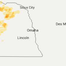
| 9:40 PM CDT | Branches down in bon homme county SD, 48.2 miles NE of Oneill, NE |
| 9:44 PM CDT | Storm damage reported in deuel county SD, 56.4 miles WSW of Montevideo, MN |
| 10:27 PM CDT | Golf cart blown across parking lo in turner county SD, 31.3 miles SW of Sioux Falls, SD |
Alabama
| Local Time | Report Details |
|---|---|
| 4:10 PM CDT | Thunderstorm winds resulted in powerlines being blown down along us-31 near spanish for in baldwin county AL, 8.6 miles E of Mobile, AL |
| 4:19 PM CDT | Severe thunderstorm winds blew down a street sign along ih-10 near virginia stree in mobile county AL, 1.1 miles S of Mobile, AL |
| 4:19 PM CDT | Severe thunderstorms blew down powerlines along washington avenue in downtown mobil in mobile county AL, 0.5 miles SSE of Mobile, AL |
| 4:22 PM CDT | Severe thunderstorm winds blew down trees near michael donald avenu in mobile county AL, 0.5 miles WNW of Mobile, AL |
| 4:22 PM CDT | Severe thunderstorm blew down trees along brook avenu in mobile county AL, 3.9 miles SW of Mobile, AL |
| 4:22 PM CDT | Severe thunderstorm winds blew down trees near dauphin island parkway and rosedal in mobile county AL, 5.1 miles SSW of Mobile, AL |
| 4:27 PM CDT | Kbfm asos reported 66 knot wind gus in mobile county AL, 4 miles SSW of Mobile, AL |
| 4:31 PM CDT | Buccaneer yacht club weather station repor in mobile county AL, 7.4 miles S of Mobile, AL |
| 4:37 PM CDT | Severe thunderstorm blew down trees near intersection of mcdonald rd and theodore-dawes r in mobile county AL, 13.3 miles WSW of Mobile, AL |
| 4:39 PM CDT | Severe thunderstorm blew down trees and powerlines near intersection of cody rd and grelot r in mobile county AL, 9.5 miles W of Mobile, AL |
| 5:00 PM CDT | Severe thunderstorm blew down powerlines at intersection of old rock rd and governmen in mobile county AL, 11.7 miles SW of Mobile, AL |
Nebraska
| Local Time | Report Details |
|---|---|
| 3:30 PM MDT | Quarter sized hail reported near Harrison, NE, 61.6 miles NNW of Scottsbluff, NE |
| 4:45 PM CDT | Tea Cup sized hail reported near Maxwell, NE, 12.7 miles ENE of North Platte, NE |
| 5:15 PM CDT | Baseball sized hail reported near Stapleton, NE, 27.3 miles NE of North Platte, NE |
| 4:56 PM MDT | Half Dollar sized hail reported near Ashby, NE, 83 miles E of Scottsbluff, NE, broke holes in sky lights |
| 4:56 PM MDT | Storm damage reported in grant county NE, 83 miles E of Scottsbluff, NE |
| 6:00 PM CDT | Quarter sized hail reported near Oakdale, NE, 44.3 miles SE of Oneill, NE |
| 5:14 PM MDT | Quarter sized hail reported near Paxton, NE, 28 miles W of North Platte, NE, 60 mph outflow wind estimated. |
| 6:15 PM CDT | Quarter sized hail reported near Neligh, NE, 38.9 miles SE of Oneill, NE |
| 5:18 PM MDT | Quarter sized hail reported near Hyannis, NE, 81 miles NW of North Platte, NE |
| 6:19 PM CDT | Half Dollar sized hail reported near Neligh, NE, 38.9 miles SE of Oneill, NE, report received from social media. |
| 6:29 PM CDT | Golf Ball sized hail reported near Sutherland, NE, 19.2 miles W of North Platte, NE |
| 6:29 PM CDT | Hen Egg sized hail reported near Sutherland, NE, 19.1 miles W of North Platte, NE, sutherland and i80 |
| 5:35 PM MDT | Quarter sized hail reported near Whitman, NE, 67.8 miles SW of Valentine, NE |
| 5:42 PM MDT | Quarter sized hail reported near Whitman, NE, 75.4 miles NW of North Platte, NE, 50 mph winds |
| 6:46 PM CDT | Quarter sized hail reported near North Platte, NE, 10.9 miles WNW of North Platte, NE |
| 6:00 PM MDT | Storm damage reported in hooker county NE, 57.3 miles NNW of North Platte, NE |
| 6:10 PM MDT | Storm damage reported in hooker county NE, 62.7 miles SSW of Valentine, NE |
| 6:15 PM MDT | Storm damage reported in hooker county NE, 61.1 miles SSW of Valentine, NE |
| 7:16 PM CDT | Quarter sized hail reported near North Platte, NE, 6.5 miles N of North Platte, NE, largest stone measured 1.125 inch in diameter. |
| 7:23 PM CDT | Half Dollar sized hail reported near North Platte, NE, 7.4 miles NE of North Platte, NE |
| 7:26 PM CDT | Hen Egg sized hail reported near Pierce, NE, 50.8 miles ESE of Oneill, NE |
| 7:29 PM CDT | Storm damage reported in thomas county NE, 59.3 miles SSW of Valentine, NE |
| 7:35 PM CDT | Quarter sized hail reported near North Platte, NE, 9.6 miles NE of North Platte, NE |
| 7:38 PM CDT | Quarter sized hail reported near North Platte, NE, 12.9 miles NE of North Platte, NE |
| 7:40 PM CDT | Storm damage reported in thomas county NE, 59.1 miles N of North Platte, NE |
| 7:48 PM CDT | Gusts estimated to be at least 70 mp in cherry county NE, 43.1 miles S of Valentine, NE |
| 7:55 PM CDT | High winds have been blowing since 740 pm in thomas county NE, 59.1 miles N of North Platte, NE |
| 8:12 PM CDT | Quarter sized hail reported near Ainsworth, NE, 58.9 miles SE of Valentine, NE |
| 8:32 PM CDT | Storm damage reported in brown county NE, 54.9 miles SE of Valentine, NE |
| 8:42 PM CDT | Quarter sized hail reported near Oneill, NE, 5.1 miles ENE of Oneill, NE |
| 9:24 PM CDT | Quarter sized hail reported near Mason City, NE, 58.4 miles WNW of Grand Island, NE, soft hail with most stones smaller than nickels...a few to the size of quarters. |
| 9:30 PM CDT | Ping Pong Ball sized hail reported near Mason City, NE, 55.1 miles WNW of Grand Island, NE |
| 9:59 PM CDT | Quarter sized hail reported near Ravenna, NE, 36.3 miles WNW of Grand Island, NE, quarter size hail and 40 mph winds. |
| 10:25 PM CDT | Storm damage reported in wayne county NE, 75.1 miles E of Oneill, NE |
Wyoming
| Local Time | Report Details |
|---|---|
| 3:33 PM MDT | Quarter sized hail reported near Lusk, WY, 74 miles NNW of Scottsbluff, NE, wydot site. |
Kansas
| Local Time | Report Details |
|---|---|
| 5:02 PM CDT | Storm damage reported in pawnee county KS, 43.2 miles SSE of Hays, KS |
| 5:30 PM CDT | 8 to 10 powerpoles down. along highway 83... south of pine s in seward county KS, 65.5 miles S of Garden City, KS |
| 5:30 PM CDT | Irrigation system flipped around a half mile south of intersection at roads e and in seward county KS, 58.7 miles S of Garden City, KS |
| 5:38 PM CDT | Golf Ball sized hail reported near Larned, KS, 49.3 miles SSE of Hays, KS |
| 6:01 PM CDT | Quarter sized hail reported near Colby, KS, 0.6 miles SSW of Colby, KS |
| 6:30 PM CDT | Trees dow in seward county KS, 64.4 miles S of Garden City, KS |
| 6:30 PM CDT | Numerous 3 to 4 inch diameter tree limbs down in addition to 1.60" rainfal in meade county KS, 67.3 miles NW of Woodward, OK |
| 6:45 PM CDT | Tree dow in seward county KS, 52.5 miles S of Garden City, KS |
| 6:48 PM CDT | Ping Pong Ball sized hail reported near Albert, KS, 38.1 miles SSE of Hays, KS |
| 6:55 PM CDT | Quarter sized hail reported near Great Bend, KS, 39.1 miles SSE of Hays, KS |
| 8:21 PM CDT | Delayed report of damaging wind gusts from last evening storms in harper county KS, 53.2 miles SW of Wichita, KS |
| 8:38 PM CDT | Half Dollar sized hail reported near Larned, KS, 43.3 miles SSE of Hays, KS |
| 9:05 PM CDT | Tree limbs down... residential fence damage and a window broke at the coop elevator. time estimate in rush county KS, 28.4 miles S of Hays, KS |
| 10:27 PM CDT | Storm damage reported in saline county KS, 64.1 miles WSW of Manhattan, KS |
North Dakota
| Local Time | Report Details |
|---|---|
| 5:10 PM CDT | Quarter sized hail reported near Rogers, ND, 63.6 miles WNW of Fargo, ND, minor crop damage and several automobile dents. |
| 5:21 PM CDT | Quarter sized hail reported near Valley City, ND, 55.3 miles WNW of Fargo, ND, quarter size hail currently falling at the intersection of 123rd avene and 21st street se. |
| 5:57 PM CDT | Quarter sized hail reported near Ayr, ND, 35.4 miles WNW of Fargo, ND |
| 6:28 PM CDT | Tennis Ball sized hail reported near Amenia, ND, 21.8 miles WNW of Fargo, ND, tennis ball size hail reported just east of amenia. |
| 6:55 PM CDT | A few large 3 to 5 inch diameter tree branches broken down in a farm shelter belt. report posted via social medi in cass county ND, 13 miles NW of Fargo, ND |
| 7:05 PM CDT | Quarter sized hail reported near Oakes, ND, 48 miles NNE of Aberdeen, SD, very heavy rain accompanied the hail. |
| 7:05 PM CDT | Golf Ball sized hail reported near Valley City, ND, 59.3 miles WNW of Fargo, ND |
| 7:25 PM CDT | Quarter sized hail reported near Oakes, ND, 49.5 miles NNE of Aberdeen, SD, brief large hail on the south side of oakes. |
Georgia
| Local Time | Report Details |
|---|---|
| 6:55 PM EDT | Tree down near stage rd and rupp rd. time estimated by rada in thomas county GA, 41.8 miles NNE of Tallahassee, FL |
| 7:00 PM EDT | Tree down in ochlocknee in thomas county GA, 39.7 miles NNE of Tallahassee, FL |
Kentucky
| Local Time | Report Details |
|---|---|
| 7:34 PM EDT | Numerous trees downed on burlington pike in belleview near fifth stree in boone county KY, 19.3 miles WSW of Cincinnati, OH |
| 7:52 PM EDT | One large tree downed and blocking us route 42 near richwood roa in boone county KY, 18 miles SSW of Cincinnati, OH |
| 7:59 PM EDT | Several 6 inch brances on down on hutton drive in boone county KY, 17.5 miles SSW of Cincinnati, OH |
| 7:59 PM EDT | One large tree downed and blocking the roadway near the intersection of hicks pike and richwood church roa in boone county KY, 15.7 miles SSW of Cincinnati, OH |
| 7:59 PM EDT | Quarter sized hail reported near Walton, KY, 17.5 miles SSW of Cincinnati, OH |
| 8:04 PM EDT | Trained spotter with home weather station measured 60 mph wind gust at 804 p in kenton county KY, 15.8 miles S of Cincinnati, OH |
| 10:28 PM EDT | Numerous trees and power lines down in jefferson county KY, 19.8 miles NNE of Louisville, KY |
| 10:29 PM EDT | Trees limbs reported down on car in jefferson county KY, 17 miles N of Louisville, KY |
| 10:39 PM EDT | Storm damage reported in jefferson county KY, 25.6 miles NNE of Louisville, KY |
| 10:41 PM EDT | Reported at louisville international airpor in jefferson county KY, 16.1 miles N of Louisville, KY |
| 10:42 PM EDT | Large tree down on power line in jefferson county KY, 16.7 miles N of Louisville, KY |
| 10:44 PM EDT | Storm damage reported in jefferson county KY, 13.4 miles NNW of Louisville, KY |
| 10:47 PM EDT | Numerous reports of power outages in the cit in jefferson county KY, 16.1 miles N of Louisville, KY |
| 10:50 PM EDT | Trees reported dow in jefferson county KY, 17.3 miles NNE of Louisville, KY |
| 10:54 PM EDT | Over 9000 without powe in jefferson county KY, 16.1 miles N of Louisville, KY |
| 11:41 PM EDT | Storm damage reported in anderson county KY, 42.8 miles E of Louisville, KY |
| 12:05 AM EDT | Downed tree limb blocking the road at iron works and newtown pik in fayette county KY, 40.9 miles NW of Irvine, KY |
| 1:00 AM EDT | Multiple large tree limbs down. report received via faceboo in pulaski county KY, 50.7 miles SW of Irvine, KY |
Minnesota
| Local Time | Report Details |
|---|---|
| 7:23 PM CDT | Golf Ball sized hail reported near Browns Valley, MN, 69.9 miles NW of Montevideo, MN |
| 8:00 PM CDT | Hen Egg sized hail reported near Beardsley, MN, 64.1 miles NW of Montevideo, MN, relayed through media...time estimated |
| 8:05 PM CDT | Baseball sized hail reported near Beardsley, MN, 64.1 miles NW of Montevideo, MN |
| 9:10 PM CDT | Rooftop anemometer in town in big stone county MN, 42.7 miles NW of Montevideo, MN |
| 9:26 PM CDT | Branches down in tow in stevens county MN, 48.1 miles NNW of Montevideo, MN |
| 9:31 PM CDT | Power outage in tow in lac qui parle county MN, 23.5 miles W of Montevideo, MN |
| 9:35 PM CDT | Storm damage reported in lac qui parle county MN, 22.8 miles W of Montevideo, MN |
| 9:54 PM CDT | Storm damage reported in lac qui parle county MN, 11.8 miles WSW of Montevideo, MN |
| 10:13 PM CDT | Storm damage reported in chippewa county MN, 0.2 miles SW of Montevideo, MN |
| 10:14 PM CDT | Storm damage reported in chippewa county MN, 0.2 miles SW of Montevideo, MN |
| 10:14 PM CDT | Storm damage reported in swift county MN, 26 miles NNE of Montevideo, MN |
| 10:20 PM CDT | Construction barricades blown threw the air approximately 20 feet. reported via twitte in chippewa county MN, 0.2 miles SW of Montevideo, MN |
| 10:38 PM CDT | Medium size tree topple in kandiyohi county MN, 34.7 miles ENE of Montevideo, MN |
| 10:50 PM CDT | Storm damage reported in yellow medicine county MN, 13.1 miles SE of Montevideo, MN |
| 10:52 PM CDT | Storm damage reported in chippewa county MN, 13.1 miles SE of Montevideo, MN |
| 11:35 PM CDT | Tree down on power lin in mcleod county MN, 56 miles WSW of Minneapolis, MN |
| 11:48 PM CDT | Large tree down at yacht ave and 100th st northeast of stewar in mcleod county MN, 61.6 miles WSW of Minneapolis, MN |
| 11:55 PM CDT | Roof off of a house on vega av in carver county MN, 35.2 miles WSW of Minneapolis, MN |
| 12:00 AM CDT | Via wunderground/the weather channe in carver county MN, 38.2 miles WSW of Minneapolis, MN |
| 12:00 AM CDT | Ampitheatre band shell ripped from 3 foot stakes...turned over and twisted. occurred near downtown and near minnesota river. several medium to large trees toppled acros in blue earth county MN, 66.3 miles SSW of Minneapolis, MN |
| 12:02 AM CDT | Power lines and many trees toppled in the cit in carver county MN, 28.7 miles W of Minneapolis, MN |
| 12:10 AM CDT | Tree damag in wright county MN, 32.2 miles WNW of Minneapolis, MN |
| 12:13 AM CDT | Large chunks of tree debris falling. reported via twitte in wright county MN, 32.2 miles WNW of Minneapolis, MN |
| 12:23 AM CDT | Huge tree limbs smashed vehicles in town. report via twitte in carver county MN, 27.3 miles WSW of Minneapolis, MN |
| 12:27 AM CDT | Storm damage reported in hennepin county MN, 15 miles W of Minneapolis, MN |
| 12:33 AM CDT | Uprooted trees in town. reported via twitte in carver county MN, 27.3 miles WSW of Minneapolis, MN |
| 12:35 AM CDT | Trees dow in scott county MN, 21.3 miles SSW of Minneapolis, MN |
| 12:36 AM CDT | Via weather underground/the weather channe in hennepin county MN, 4.7 miles W of Minneapolis, MN |
| 12:38 AM CDT | Power outag in blue earth county MN, 66.3 miles SSW of Minneapolis, MN |
| 12:40 AM CDT | Storm damage reported in hennepin county MN, 6.7 miles SSW of Minneapolis, MN |
| 12:40 AM CDT | Four to five inch diameter tree limbs severed. occurred on dallas lane north. dime size hail also reporte in hennepin county MN, 11.1 miles NW of Minneapolis, MN |
| 12:40 AM CDT | Tree limbs down at 179th st west and flagstaff av in dakota county MN, 20.2 miles S of Minneapolis, MN |
| 12:41 AM CDT | Via weather underground/the weather channe in dakota county MN, 22.7 miles S of Minneapolis, MN |
| 12:53 AM CDT | Storm damage reported in ramsey county MN, 10.6 miles ESE of Minneapolis, MN |
| 12:54 AM CDT | Twelve to sixteen inch diameter trees snapped off about 20 feet above the ground. reported via twitte in carver county MN, 29.8 miles W of Minneapolis, MN |
| 12:56 AM CDT | Sixty five to 70 mph winds reported by weather eye radi in ramsey county MN, 6 miles NNE of Minneapolis, MN |
| 1:00 AM CDT | Large tree limbs down...mainly 2 inches or slightly greater in diamete in dakota county MN, 18.5 miles SSE of Minneapolis, MN |
| 1:00 AM CDT | Multiple trees and large limbs dow in ramsey county MN, 12.5 miles NE of Minneapolis, MN |
| 1:04 AM CDT | Numerous medium size tree limbs severed. one as large as 5 to 6 inches in diameter. reported by weather eye radi in ramsey county MN, 6 miles NNE of Minneapolis, MN |
| 1:05 AM CDT | Power out for approximately one hou in carver county MN, 28.7 miles W of Minneapolis, MN |
| 1:14 AM CDT | Large tree branch damaged roof near christmas lake. power also lost on sit in hennepin county MN, 15 miles WSW of Minneapolis, MN |
| 1:15 AM CDT | Several 6 inch diameter trees toppled. occurred in northwest portion of cit in washington county MN, 19.5 miles NE of Minneapolis, MN |
| 1:30 AM CDT | One tree snapped in half at harriet and w 36th stree in hennepin county MN, 3.4 miles S of Minneapolis, MN |
| 1:44 AM CDT | Twelve inch diameter tree felle in hennepin county MN, 6.9 miles S of Minneapolis, MN |
| 1:45 AM CDT | Car smashed by large tree. half of city out of power. reported via twitte in carver county MN, 27.3 miles WSW of Minneapolis, MN |
| 1:54 AM CDT | Tree down on county road 2 in millville. time estimated based on rada in wabasha county MN, 60.3 miles WNW of La Crosse, WI |
| 2:05 AM CDT | A few trees down along highway 42 near kellogg. time estimated using rada in wabasha county MN, 50.7 miles NW of La Crosse, WI |
| 2:06 AM CDT | Medium size tree broken off 4 feet above the ground. reported via twitter. additional trees down as wel in scott county MN, 33.2 miles SSW of Minneapolis, MN |
| 2:06 AM CDT | Damage noted from near hazelton/vega ave. to 2 sw watertown. report via twitte in carver county MN, 29.8 miles W of Minneapolis, MN |
| 2:07 AM CDT | A few trees rerorted down along highway 61 between lake city and wabasha. time estimated using rada in wabasha county MN, 55.3 miles NW of La Crosse, WI |
| 2:07 AM CDT | A few trees reported down along highway 61 between lake city and wabasha. time estimated using rada in wabasha county MN, 55.3 miles NW of La Crosse, WI |
| 3:27 AM CDT | Several trees down and no power in southern lino lake in anoka county MN, 15.4 miles NE of Minneapolis, MN |
Arizona
| Local Time | Report Details |
|---|---|
| 5:35 PM MST | 6 large trees blown down with est. 12 in. diameter trunks and minor street floodin in maricopa county AZ, 16 miles W of Phoenix, AZ |
| 10:30 PM MST | 65 mph winds between 1st and 3rd streets in bullhead cit in mohave county AZ, 47.6 miles NNW of Lake Havasu City, AZ |
| 11:00 PM MST | Several 4 foot tall trees blown over along the bullhead parkwa in mohave county AZ, 48 miles NNW of Lake Havasu City, AZ |
California
| Local Time | Report Details |
|---|---|
| 5:51 PM PDT | Thunderstorms produced a 60 mph wind gust at borrego springs air ranc in san diego county CA, 60.8 miles ENE of San Diego, CA |
| 6:05 PM PDT | 64 mph gust recorded at needles airpor in san bernardino county CA, 25.7 miles NW of Lake Havasu City, AZ |
| 6:15 PM PDT | Public report of minor roof damage to a business in needle in san bernardino county CA, 30.3 miles NNW of Lake Havasu City, AZ |
| 7:01 PM PDT | Chp reports a semi blown over on i-40. power lines knocked down over blocking i-40 in both direction in san bernardino county CA, 28.5 miles NNW of Lake Havasu City, AZ |
| 7:15 PM PDT | Trained spotter reports two 20 ft palms downed in his yard with several others in neighboring yard in san bernardino county CA, 29.4 miles NNW of Lake Havasu City, AZ |
Michigan
| Local Time | Report Details |
|---|---|
| 9:55 PM EDT | Half Dollar sized hail reported near Dowagiac, MI, 71.7 miles SSW of Grand Rapids, MI |
Utah
| Local Time | Report Details |
|---|---|
| 9:20 PM MDT | Ut33 i80 at mp 29 4125 f in tooele county UT, 84.6 miles W of Salt Lake City, UT |
| 9:25 PM MDT | Dpg17 at i-80 4125 f in tooele county UT, 83 miles W of Salt Lake City, UT |
Iowa
| Local Time | Report Details |
|---|---|
| 11:13 PM CDT | 4 inch diameter tree branches blowing down by estimated wind gusts at 65 mp in woodbury county IA, 63.3 miles W of Storm Lake, IA |
Nevada
| Local Time | Report Details |
|---|---|
| 10:38 PM PDT | Spotter reports estimated gusts over 60 mph at davis da in clark county NV, 51.1 miles NNW of Lake Havasu City, AZ |
Wisconsin
| Local Time | Report Details |
|---|---|
| 1:45 AM CDT | Several 8 to 10 inch diameter trees toppled. a three foot willow tree felled. several antennas ripped down. twelve foot trailer attached to vehicle flipped on its sid in dunn county WI, 64.8 miles ESE of Minneapolis, MN |
| 1:54 AM CDT | Trees toppled onto hous in eau claire county WI, 70.6 miles N of La Crosse, WI |
| 2:00 AM CDT | Tree damage. power ou in pierce county WI, 51.7 miles E of Minneapolis, MN |
| 2:00 AM CDT | Twelve inch diameter tree down. power also ou in dunn county WI, 58.4 miles E of Minneapolis, MN |
| 2:17 AM CDT | A few trees down in buffalo. one tree fell onto a vehicl in buffalo county WI, 41.7 miles NW of La Crosse, WI |
| 2:24 AM CDT | Trees downn and power is ou in trempealeau county WI, 54.1 miles NNW of La Crosse, WI |
| 2:31 AM CDT | Tree reported dow in buffalo county WI, 30.8 miles NW of La Crosse, WI |
| 2:39 AM CDT | Trees down in the city of arcadia. time estimated using rada in trempealeau county WI, 32.4 miles NNW of La Crosse, WI |
| 3:00 AM CDT | Estimated 55 to 60 mph wind gus in la crosse county WI, 5.6 miles NNE of La Crosse, WI |
| 3:00 AM CDT | Power pole reported down in thor in clark county WI, 82.3 miles SW of Rhinelander, WI |
| 3:13 AM CDT | Two 10 inch diameter oak trees down over the southbound lane of hwy 12/27. power line down in brockway. other trees down blocking road in jackson county WI, 39.2 miles NNE of La Crosse, WI |
| 3:34 AM CDT | Tree down on a power lin in monroe county WI, 23.8 miles ENE of La Crosse, WI |
| 4:00 AM CDT | Trees down in cit in marathon county WI, 62.5 miles SSW of Rhinelander, WI |
| 4:08 AM CDT | Many trees down in city...no power. via social medi in wood county WI, 76.4 miles ENE of La Crosse, WI |
| 4:12 AM CDT | Trees down in cit in portage county WI, 74.9 miles SSW of Rhinelander, WI |
| 4:13 AM CDT | Trees on roa in marathon county WI, 56.8 miles SSW of Rhinelander, WI |
| 4:26 AM CDT | Trees and powerlines down in cit in portage county WI, 76.6 miles W of Green Bay, WI |
| 4:51 AM CDT | Power out in cit in portage county WI, 64.2 miles W of Green Bay, WI |
| 5:35 AM CDT | Storm damage reported in winnebago county WI, 43.8 miles SW of Green Bay, WI |
| 5:40 AM CDT | Large tree down on powerlin in fond du lac county WI, 52.9 miles NNE of Madison, WI |
| 5:41 AM CDT | Storm damage reported in winnebago county WI, 43.8 miles SW of Green Bay, WI |
| 5:41 AM CDT | 14 vendor tents overturned at rock usa..1 injured in winnebago county WI, 43.8 miles SW of Green Bay, WI |
| 5:48 AM CDT | Storm damage reported in winnebago county WI, 31.3 miles SW of Green Bay, WI |
| 5:50 AM CDT | Storm damage reported in calumet county WI, 26.9 miles SSW of Green Bay, WI |
| 6:30 AM CDT | Trees down in northern parts of the county and in plymouth in sheboygan county WI, 52.7 miles S of Green Bay, WI |
Connect with Interactive Hail Maps