

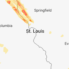
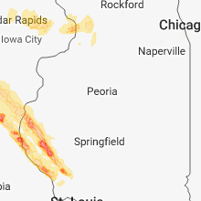
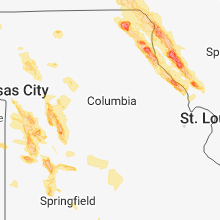
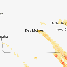
Hail Map for Thursday, July 19, 2018

Number of Impacted Households on 7/19/2018
0
Impacted by 1" or Larger Hail
0
Impacted by 1.75" or Larger Hail
0
Impacted by 2.5" or Larger Hail
Square Miles of Populated Area Impacted on 7/19/2018
0
Impacted by 1" or Larger Hail
0
Impacted by 1.75" or Larger Hail
0
Impacted by 2.5" or Larger Hail


Cities Most Affected by Hail Storms of 7/19/2018
| Hail Size | Demographics of Zip Codes Affected | ||||||
|---|---|---|---|---|---|---|---|
| City | Count | Average | Largest | Pop Density | House Value | Income | Age |
| Lone Jack, MO | 3 | 2.08 | 2.75 | 79 | $128k | $55.0k | 41.8 |
| Warrensburg, MO | 3 | 1.75 | 1.75 | 141 | $93k | $33.4k | 26.1 |
| Pleasant Hill, MO | 2 | 2.25 | 2.75 | 106 | $102k | $52.4k | 38.0 |
| Lees Summit, MO | 2 | 1.88 | 2.00 | 3382 | $105k | $51.9k | 34.0 |
| Ford, KS | 2 | 1.88 | 2.00 | 2 | $32k | $35.2k | 40.9 |
| Gorin, MO | 2 | 1.75 | 1.75 | 8 | $27k | $22.3k | 36.3 |
| La Grange, MO | 2 | 1.75 | 1.75 | 25 | $51k | $31.7k | 43.2 |
| Wright, KS | 1 | 3.00 | 3.00 | 2 | $83k | $38.8k | 41.7 |
| Garden City, MO | 1 | 1.75 | 1.75 | 29 | $84k | $41.3k | 38.9 |
| Garden City, KS | 1 | 1.75 | 1.75 | 44 | $85k | $38.1k | 30.2 |
| Sublette, KS | 1 | 1.75 | 1.75 | 2 | $88k | $39.7k | 34.5 |
| Pittsfield, IL | 1 | 1.75 | 1.75 | 37 | $68k | $31.3k | 43.0 |
| Kingsville, MO | 1 | 1.75 | 1.75 | 51 | $91k | $46.7k | 43.8 |
Hail and Wind Damage Spotted on 7/19/2018
Filter by Report Type:Hail ReportsWind Reports
States Impacted
Missouri, Kansas, Mississippi, Arizona, Alabama, Oklahoma, Iowa, North Dakota, Texas, Arkansas, Illinois, South Dakota, Nebraska, Tennessee, NevadaMissouri
| Local Time | Report Details |
|---|---|
| 10:36 AM CDT | Delayed report... time matched to radar: tree blown down on hom in johnson county MO, 60.2 miles ESE of Kansas City, MO |
| 10:37 AM CDT | Peak gusts at kszl per local base weather statio in johnson county MO, 61 miles ESE of Kansas City, MO |
| 10:40 AM CDT | 8" tree knocked down and significant flag pole bent on hwy d 5 miles south of u.s. 5 in johnson county MO, 62.4 miles ESE of Kansas City, MO |
| 10:40 AM CDT | Quarter sized hail reported near Knob Noster, MO, 62 miles ESE of Kansas City, MO, from trained spotter. |
| 10:48 AM CDT | Delayed report: three power poles broken at base... tree damage... and large business sign knocked over; all within the north side of camero in dekalb county MO, 48.7 miles NNE of Kansas City, MO |
| 11:02 AM CDT | Quarter sized hail reported near Green Ridge, MO, 61.9 miles WSW of Columbia, MO, delayed report. |
| 11:22 AM CDT | Quarter sized hail reported near Polo, MO, 42.9 miles NE of Kansas City, MO |
| 12:31 PM CDT | Multiple trees downed off of dogwood dr in camdenton. time estimated by rada in camden county MO, 63.3 miles NNE of Springfield, MO |
| 12:54 PM CDT | Golf Ball sized hail reported near Warrensburg, MO, 50.9 miles ESE of Kansas City, MO |
| 1:00 PM CDT | Golf Ball sized hail reported near Warrensburg, MO, 49.2 miles ESE of Kansas City, MO |
| 1:03 PM CDT | Golf Ball sized hail reported near Warrensburg, MO, 52.3 miles ESE of Kansas City, MO |
| 1:07 PM CDT | Multiple reports of tree and power line damage throughout warrensbur in johnson county MO, 50.9 miles ESE of Kansas City, MO |
| 1:24 PM CDT | Baseball sized hail reported near Lone Jack, MO, 27.4 miles SE of Kansas City, MO |
| 1:45 PM CDT | Baseball sized hail reported near Pleasant Hill, MO, 32.5 miles SE of Kansas City, MO |
| 1:48 PM CDT | Ping Pong Ball sized hail reported near Independence, MO, 10 miles ESE of Kansas City, MO |
| 1:53 PM CDT | Half Dollar sized hail reported near Independence, MO, 10.3 miles ESE of Kansas City, MO |
| 1:54 PM CDT | Golf Ball sized hail reported near Kingsville, MO, 36.9 miles SE of Kansas City, MO, delayed report... time matched to radar. |
| 2:15 PM CDT | Golf Ball sized hail reported near Lone Jack, MO, 27.4 miles SE of Kansas City, MO |
| 2:16 PM CDT | Hen Egg sized hail reported near Lees Summit, MO, 19 miles SE of Kansas City, MO |
| 2:16 PM CDT | Golf Ball sized hail reported near Lees Summit, MO, 17.2 miles SE of Kansas City, MO |
| 2:20 PM CDT | Golf Ball sized hail reported near Lone Jack, MO, 27.4 miles SE of Kansas City, MO |
| 2:30 PM CDT | Golf Ball sized hail reported near Pleasant Hill, MO, 26.7 miles SE of Kansas City, MO |
| 3:06 PM CDT | Ping Pong Ball sized hail reported near Garden City, MO, 43 miles SSE of Kansas City, MO, ping pong sized hail was covering the deck like it snowed. |
| 3:07 PM CDT | Golf Ball sized hail reported near Garden City, MO, 43 miles SSE of Kansas City, MO, delayed report from social media. |
| 3:12 PM CDT | Reports of numerous trees down and uprooted... as well as multiple power outages. wind gust estimates of up to 70 mp in st. clair county MO, 69 miles NNW of Springfield, MO |
| 3:30 PM CDT | Missouri 82 is closed one half mile west of route w due to a power line across the roadwa in st. clair county MO, 60.7 miles NNW of Springfield, MO |
| 3:40 PM CDT | Numerous trees down and power outage in st. clair county MO, 50.3 miles NNW of Springfield, MO |
| 3:41 PM CDT | Trees uprooted and laying in different directions at the intersection of us 54 and highway j. delayed report. time based off of rada in st. clair county MO, 52.9 miles NNW of Springfield, MO |
| 3:48 PM CDT | Fire department reporting trees down in humansville. via ham operato in polk county MO, 43.5 miles NNW of Springfield, MO |
| 3:53 PM CDT | Quarter sized hail reported near Appleton City, MO, 69.7 miles SSE of Kansas City, MO, quarter size hail. |
| 4:00 PM CDT | At about 4 pm to 4:15 pm at stockton state park. the marina was heavily damage in cedar county MO, 37.9 miles NW of Springfield, MO |
| 4:00 PM CDT | Se corner of stockton lake/ turnback creak area off the 160 in rural everton. we have 7 big oaks down in our pasture plus several large limbs. lost part of our roof als in dade county MO, 30.1 miles WNW of Springfield, MO |
| 4:45 PM CDT | Quarter sized hail reported near Appleton City, MO, 69.7 miles SSE of Kansas City, MO, pea to nickle to a few quarter size hail. |
| 4:58 PM CDT | Power lines dow in bates county MO, 50.1 miles SSE of Kansas City, MO |
| 4:58 PM CDT | Power lines dow in bates county MO, 66.3 miles ENE of Chanute, KS |
| 5:40 PM CDT | Tree and roof damage... with some shingles blown off at intersection of hwy b and county road 97. timing estimated from rada in cedar county MO, 48.6 miles NW of Springfield, MO |
| 5:50 PM CDT | Pictures via social media of multiple large tree trunks and limbs snapped off on russell street. timing estimated from rada in dade county MO, 34 miles WNW of Springfield, MO |
| 5:50 PM CDT | Corrects time of previous tstm wnd dmg report from 4 e greenfield. se corner of stockton lake/ turnback creak area off the 160 in rural everton. we have 7 big oaks down in dade county MO, 30.1 miles WNW of Springfield, MO |
| 5:54 PM CDT | Multiple trees down throughout dade count in dade county MO, 33.5 miles WNW of Springfield, MO |
| 6:00 PM CDT | Se corner of stockton lake off hwy 160 in rural everton. multiple large oak trees down in a pasture... with roof damage... also. picture from social medi in dade county MO, 29.5 miles WNW of Springfield, MO |
| 6:00 PM CDT | Corrects previous tstm wnd dmg report from 4 e greenfield. se corner of stockton lake area off hwy 160 in rural everton. multiple large oak trees down in a pasture. par in dade county MO, 30.1 miles WNW of Springfield, MO |
| 6:10 PM CDT | Trees down in the are in greene county MO, 12.5 miles WNW of Springfield, MO |
| 6:15 PM CDT | Multiple 4 in. tree limbs down off of hwy 266. timing estimated from rada in lawrence county MO, 18.7 miles W of Springfield, MO |
| 6:16 PM CDT | Measured at sgf airport aso in greene county MO, 5.8 miles WNW of Springfield, MO |
| 6:18 PM CDT | Downed power lines / trees down in lawrence county including areas near sarcoxie... stotts city... mt vernon... north of auror in jasper county MO, 46.7 miles WSW of Springfield, MO |
| 6:18 PM CDT | Downed power lines / trees down in lawrence county including areas near sarcoxie... stotts city... mt vernon... north of auror in lawrence county MO, 37.1 miles WSW of Springfield, MO |
| 6:18 PM CDT | Downed power lines / trees down in lawrence county including areas near sarcoxie... stotts city... mt vernon... north of auror in lawrence county MO, 30.1 miles WSW of Springfield, MO |
| 6:20 PM CDT | Reports of power lines down in ash grove area near lawrence 1240/lawrence 202 in greene county MO, 17.6 miles WNW of Springfield, MO |
| 6:22 PM CDT | 68 mph gust... hampton and harrison... republic... mo - measure in greene county MO, 12.1 miles WSW of Springfield, MO |
| 6:23 PM CDT | Asos sgf measured gus in greene county MO, 5.8 miles WNW of Springfield, MO |
| 6:23 PM CDT | Est 65-70 mph wind gusts on south side of republic near miller and lynn; few trees down and minor shingle damage to couple of home in greene county MO, 11.5 miles SW of Springfield, MO |
| 6:25 PM CDT | Report of a 12-24 inch tree snapped in half at sunshine & madrid streets in spf in greene county MO, 3 miles SE of Springfield, MO |
| 6:25 PM CDT | Pictures via social media of large tree branch through roof of house near plainview rd and farm road 13 in greene county MO, 6.5 miles SSW of Springfield, MO |
| 6:30 PM CDT | Mesonet station mo004... interstate 44 mm 47-mt verno in lawrence county MO, 29.2 miles WSW of Springfield, MO |
| 6:30 PM CDT | Shingles blown off a house at village terrace & golden in spf in greene county MO, 6.1 miles SSW of Springfield, MO |
| 6:30 PM CDT | Picture via social media of large tree uprooted at intersection of walnut lawn and s campbell. timing estimated from rada in greene county MO, 4.1 miles S of Springfield, MO |
| 6:30 PM CDT | Picture of large tree down on driveway off of university street. timing estimated from rada in greene county MO, 2.1 miles SSE of Springfield, MO |
| 6:30 PM CDT | Report of a 2ãƒâƒã‚â¢â€â™ tree went through a house. no injuries... but roof has collapsed... and house is virtually destroyed. time based on rada in greene county MO, 6.5 miles SSW of Springfield, MO |
| 6:30 PM CDT | 2 trees 10ãƒâƒã‚â¢â€â in diameter snappe in greene county MO, 5.5 miles SSW of Springfield, MO |
| 6:36 PM CDT | 6 inch limbs down alongside the road at north nicholas & tracker road in nixa... m in christian county MO, 9.8 miles SSW of Springfield, MO |
| 6:40 PM CDT | A few downed trees of 3-5 inches in diamete in webster county MO, 22.9 miles ENE of Springfield, MO |
| 6:46 PM CDT | Trees are dow in christian county MO, 19.9 miles S of Springfield, MO |
| 6:50 PM CDT | Report of power lines down with tree branches in st. francisville... mo. time estimated based on rada in clark county MO, 8.1 miles ENE of Kahoka, MO |
| 6:50 PM CDT | Storm damage reported in clark county MO, 5.5 miles N of Kahoka, MO |
| 7:10 PM CDT | Half Dollar sized hail reported near Memphis, MO, 22.2 miles W of Kahoka, MO, delayed report and time estimated from radar. |
| 7:12 PM CDT | Reports of trees down in taney county bull creek area 2 miles off of highway 65 one power line was down over a trailer and has been taken care of by the fire department in taney county MO, 33.5 miles S of Springfield, MO |
| 7:13 PM CDT | Downed power lines in branson along hwy 265. time based on rada in taney county MO, 39.4 miles S of Springfield, MO |
| 7:14 PM CDT | Roof damage in the hollister area with large tree limbs down. timing estimated from rada in taney county MO, 40.2 miles S of Springfield, MO |
| 7:17 PM CDT | Quarter sized hail reported near Gorin, MO, 16.4 miles WSW of Kahoka, MO, quarter size hail falling at the gorin fire department. |
| 7:23 PM CDT | Golf Ball sized hail reported near Gorin, MO, 16.4 miles WSW of Kahoka, MO, relayed report from clark co.... mo dispatch. |
| 7:25 PM CDT | Awos station bbg... branso in taney county MO, 47.1 miles S of Springfield, MO |
| 7:27 PM CDT | Golf Ball sized hail reported near Gorin, MO, 16.4 miles WSW of Kahoka, MO, reported from gorin fire department. |
| 7:36 PM CDT | One power pole snapped in field and one bent over on e 76 via fire. time based on rada in douglas county MO, 42.4 miles ESE of Springfield, MO |
| 7:38 PM CDT | Trees dow in clark county MO, 14.3 miles ESE of Kahoka, MO |
| 7:55 PM CDT | Storm damage reported in ozark county MO, 63.6 miles SE of Springfield, MO |
| 8:00 PM CDT | Trees across highway 95 south of gentryville. south of county road 345 off of hey 95 which is 3 to 4 miles south of hwy 14 east. time based on rada in douglas county MO, 56.8 miles ESE of Springfield, MO |
| 8:08 PM CDT | Tree down in wyaconda on rte in clark county MO, 10.8 miles WSW of Kahoka, MO |
| 8:28 PM CDT | Golf Ball sized hail reported near La Grange, MO, 28.1 miles SSE of Kahoka, MO, corrects previous hail report from la grange. reported relayed via lewis county 911. |
| 8:30 PM CDT | West plains missouri sheriffs office reports large tree on fence line 11miles west of west plains. time based on rada in howell county MO, 68.7 miles SSW of Salem, MO |
| 8:33 PM CDT | Quarter sized hail reported near Durham, MO, 30.5 miles S of Kahoka, MO |
| 8:34 PM CDT | Quarter sized hail reported near Maywood, MO, 32.4 miles S of Kahoka, MO, report relayed via lewis county 911. |
| 8:36 PM CDT | Golf Ball sized hail reported near La Grange, MO, 28.1 miles SSE of Kahoka, MO, reported relayed via lewis county 911. |
Kansas
| Local Time | Report Details |
|---|---|
| 11:30 AM CDT | Quarter sized hail reported near Logan, KS, 55.9 miles NNW of Hays, KS, a few pea to quarter sized hail stones. |
| 11:48 AM CDT | Dime sized hail and heavy rain als in phillips county KS, 60.3 miles N of Hays, KS |
| 12:11 PM CDT | Quarter sized hail reported near Kensington, KS, 64.1 miles NNE of Hays, KS, pea to quarter sized hail with 50mph wind gusts. |
| 12:23 PM CDT | Storm damage reported in smith county KS, 67.9 miles NNE of Hays, KS |
| 12:28 PM CDT | Est 60mph wind gust in smith county KS, 69.1 miles NNE of Hays, KS |
| 12:47 PM CDT | Storm damage reported in ottawa county KS, 71.2 miles W of Manhattan, KS |
| 1:00 PM CDT | Storm damage reported in ottawa county KS, 65.2 miles W of Manhattan, KS |
| 1:08 PM CDT | Large tree fell onto a mobile home in central salina. in addition... a semi was blown into the guardrail of a bridge on interstate 135. time estimated based on radar. r in saline county KS, 62.1 miles WSW of Manhattan, KS |
| 1:15 PM CDT | Reports of multiple medium-sized tree limbs dow in cloud county KS, 69.7 miles W of Manhattan, KS |
| 1:30 PM CDT | Storm damage reported in cloud county KS, 50.7 miles WNW of Manhattan, KS |
| 1:41 PM CDT | 1-2 foot diameter tree snapped near the base of the tree trunk... picture on social medi in clay county KS, 33 miles WNW of Manhattan, KS |
| 1:51 PM CDT | Storm damage reported in clay county KS, 30.4 miles W of Manhattan, KS |
| 2:06 PM CDT | Storm damage reported in geary county KS, 18.7 miles W of Manhattan, KS |
| 2:16 PM CDT | Social media picture showing approximately 1 foot diameter tree snapped and on top of a ca in riley county KS, 0.4 miles W of Manhattan, KS |
| 2:23 PM CDT | Storm damage reported in riley county KS, 3.4 miles WNW of Manhattan, KS |
| 2:23 PM CDT | Storm damage reported in riley county KS, 3.4 miles WNW of Manhattan, KS |
| 2:23 PM CDT | City of manhattan municipal government social media page posted a picture of a metal pole for a large street sign/stoplight that stretches over an intersection breaking in riley county KS, 0.1 miles NE of Manhattan, KS |
| 2:26 PM CDT | Storm damage reported in riley county KS, 6 miles WSW of Manhattan, KS |
| 2:26 PM CDT | (duplicate report in riley county KS, 6.4 miles WSW of Manhattan, KS |
| 2:32 PM CDT | Storm damage reported in riley county KS, 0.1 miles NE of Manhattan, KS |
| 2:36 PM CDT | Storm damage reported in riley county KS, 10.8 miles SE of Manhattan, KS |
| 2:36 PM CDT | 8" tree limb dow in pottawatomie county KS, 3.4 miles ENE of Manhattan, KS |
| 2:37 PM CDT | 60 to 70 mph wind gust in pottawatomie county KS, 14.6 miles ENE of Manhattan, KS |
| 3:15 PM CDT | Several tree limbs up to 10 inches in diameter dow in shawnee county KS, 45.2 miles E of Manhattan, KS |
| 3:18 PM CDT | Storm damage reported in shawnee county KS, 44.5 miles ESE of Manhattan, KS |
| 3:18 PM CDT | 1 foot diameter trees uproote in shawnee county KS, 51.5 miles E of Manhattan, KS |
| 3:20 PM CDT | Social media pictures of a large tree down on a house near 31st and fairlawn in topek in shawnee county KS, 45.7 miles ESE of Manhattan, KS |
| 3:20 PM CDT | 3 foot diameter tree 20 to 30 ft tall split and blocking traffic at 200 main stree in jefferson county KS, 53.3 miles E of Manhattan, KS |
| 3:20 PM CDT | Numerous trees and large tree branches down... some blocking road in shawnee county KS, 46.6 miles ESE of Manhattan, KS |
| 3:22 PM CDT | Social media pictures of multiple business signs and power poles down on 29th street between fairlawn and wanamake in shawnee county KS, 44.6 miles ESE of Manhattan, KS |
| 3:23 PM CDT | Storm damage reported in shawnee county KS, 50.5 miles E of Manhattan, KS |
| 3:24 PM CDT | Storm damage reported in shawnee county KS, 50.3 miles ESE of Manhattan, KS |
| 3:24 PM CDT | Corrects previous tstm wnd gst report from 1 se pauline. (duplicate report in shawnee county KS, 50 miles ESE of Manhattan, KS |
| 3:25 PM CDT | Large 1 to 2 foot diameter tree branch snappe in shawnee county KS, 52.8 miles ESE of Manhattan, KS |
| 3:31 PM CDT | Storm damage reported in douglas county KS, 48.1 miles W of Kansas City, MO |
| 3:33 PM CDT | Storm damage reported in coffey county KS, 55.3 miles NNW of Chanute, KS |
| 3:34 PM CDT | Roof blown off hous in coffey county KS, 55.3 miles NNW of Chanute, KS |
| 3:35 PM CDT | (duplicate report: 60-70 mph wind gusts with pea size hail in shawnee county KS, 54.5 miles W of Kansas City, MO |
| 3:39 PM CDT | Storm damage reported in douglas county KS, 48.1 miles W of Kansas City, MO |
| 3:40 PM CDT | Storm damage reported in douglas county KS, 40.2 miles WSW of Kansas City, MO |
| 3:44 PM CDT | Storm damage reported in douglas county KS, 33.1 miles WSW of Kansas City, MO |
| 3:44 PM CDT | Small tree snapped near the base of the tree trun in douglas county KS, 37.2 miles WSW of Kansas City, MO |
| 3:46 PM CDT | Storm damage reported in douglas county KS, 34.7 miles W of Kansas City, MO |
| 3:53 PM CDT | Medium to large tree limbs dow in anderson county KS, 49.3 miles NNE of Chanute, KS |
| 3:53 PM CDT | Medium to large tree limbs dow in anderson county KS, 45.4 miles N of Chanute, KS |
| 3:54 PM CDT | Tree and building damage reported across tow in anderson county KS, 44 miles N of Chanute, KS |
| 3:57 PM CDT | Shingles blown off hous in franklin county KS, 44.2 miles SW of Kansas City, MO |
| 3:57 PM CDT | Storm damage reported in franklin county KS, 43.8 miles SW of Kansas City, MO |
| 3:59 PM CDT | Storm damage reported in anderson county KS, 46.1 miles N of Chanute, KS |
| 3:59 PM CDT | Large tree branches dow in franklin county KS, 37.1 miles SW of Kansas City, MO |
| 4:02 PM CDT | Storm damage reported in douglas county KS, 38.7 miles SW of Kansas City, MO |
| 4:04 PM CDT | Power line down across 214th and linwood r in leavenworth county KS, 27.7 miles WSW of Kansas City, MO |
| 4:06 PM CDT | Estimated peak gusts of 85 to 90 mph in anderson county KS, 43.3 miles NNE of Chanute, KS |
| 4:15 PM CDT | Power lines down on 6th street. time matched to rada in miami county KS, 46.1 miles SSW of Kansas City, MO |
| 4:20 PM CDT | Picture on social media of 10 inch diameter tree snappe in anderson county KS, 49.9 miles NNE of Chanute, KS |
| 4:25 PM CDT | 6 inch limbs down and shingles blown off roo in linn county KS, 37.4 miles NE of Chanute, KS |
| 4:35 PM CDT | Tree down over power line... power ou in linn county KS, 53.1 miles NE of Chanute, KS |
| 4:39 PM CDT | Tree limbs down in iola from thunderstorm winds estimated around 60mp in allen county KS, 17.2 miles N of Chanute, KS |
| 4:48 PM CDT | Storm damage reported in allen county KS, 22.5 miles NE of Chanute, KS |
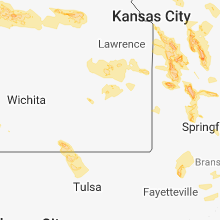
| 6:28 PM CDT | Tea Cup sized hail reported near Wright, KS, 56.6 miles ESE of Garden City, KS, 3.5" hail. |
| 6:43 PM CDT | Quarter sized hail reported near Wright, KS, 54.8 miles ESE of Garden City, KS |
| 7:09 PM CDT | Hen Egg sized hail reported near Ford, KS, 64.3 miles ESE of Garden City, KS |
| 7:19 PM CDT | Quarter sized hail reported near Sublette, KS, 24.2 miles S of Garden City, KS |
| 7:24 PM CDT | Quarter sized hail reported near Ford, KS, 66.8 miles ESE of Garden City, KS, facebook post quarter size hail. |
| 7:31 PM CDT | Golf Ball sized hail reported near Ford, KS, 66.8 miles ESE of Garden City, KS, facebook post with golf ball south of ford. |
| 7:39 PM CDT | Quarter sized hail reported near Lakin, KS, 25 miles WSW of Garden City, KS |
| 7:41 PM CDT | Golf Ball sized hail reported near Sublette, KS, 22.7 miles S of Garden City, KS, facebook post golf ball size north of sublette. |
| 7:50 PM CDT | Half Dollar sized hail reported near Satanta, KS, 23.9 miles SSW of Garden City, KS, half dollar size. |
| 8:00 PM CDT | Quarter sized hail reported near Sublette, KS, 24.2 miles S of Garden City, KS |
| 8:25 PM CDT | Corrects previous non-tstm wnd gst report from garden city regional airport. asos station gck... garden city regional airpor in finney county KS, 8.8 miles ESE of Garden City, KS |
| 8:30 PM CDT | Golf Ball sized hail reported near Garden City, KS, 12.6 miles ESE of Garden City, KS, golf ball size. |
| 8:45 PM CDT | Quarter sized hail reported near Garden City, KS, 2.2 miles N of Garden City, KS, social media quarter size. |
| 8:57 PM CDT | Quarter sized hail reported near Cimarron, KS, 31.9 miles ENE of Garden City, KS |
| 9:19 PM CDT | Quarter sized hail reported near Jetmore, KS, 47.2 miles E of Garden City, KS |
| 9:55 PM CDT | Ping Pong Ball sized hail reported near Jetmore, KS, 53.4 miles E of Garden City, KS, law enforcement report ping pong size hail. |
Mississippi
| Local Time | Report Details |
|---|---|
| 2:35 PM CDT | Trees down... a few on power lines in forest. reported by sheriff's offic in scott county MS, 41.8 miles E of Jackson, MS |
| 2:40 PM CDT | A couple trees down in morton. reported by sheriff's offic in scott county MS, 30.7 miles E of Jackson, MS |
| 2:45 PM CDT | Trees down in lake. reported by sheriff's offic in scott county MS, 49.9 miles E of Jackson, MS |
| 5:05 PM CDT | Trees and powerlines down on watson rd. reported by em in forrest county MS, 82 miles SE of Jackson, MS |
| 5:08 PM CDT | Trees down near the morriston community along mars hill road and county line road. tree was blocking the road. reported by em in jones county MS, 83.1 miles SE of Jackson, MS |
| 8:05 PM CDT | Quarter sized hail reported near Olive Branch, MS, 21.9 miles SE of Memphis, TN, quarter size hail observed in east olive branch. |
| 8:25 PM CDT | Tree split off of center hill road south of highway 30 in desoto county MS, 23.2 miles SE of Memphis, TN |
| 10:33 PM CDT | 85 to 90 percent of the roof at the days inn hotel blown of in panola county MS, 58.3 miles S of Memphis, TN |
| 11:28 PM CDT | 74 mph wind gust recorded at kglh. 47 mpg sustained win in washington county MS, 72.7 miles NE of Bastrop, LA |
Arizona
| Local Time | Report Details |
|---|---|
| 1:26 PM MST | Quarter sized hail reported near Flagstaff, AZ, 4.2 miles ESE of Flagstaff, AZ |
| 5:05 PM MST | Mesonet station qbha3... black hill in graham county AZ, 80.8 miles S of Show Low, AZ |
| 5:34 PM MST | Quarter sized hail reported near Ash Fork, AZ, 47.5 miles W of Flagstaff, AZ, quarter-size hail was reported by a trained spotter in ash fork... az at 3:45 and 4:00 pm mst. |
| 7:25 PM MST | Olaf knolls raws recorded 62mph wind gusts. time estimated from rada in mohave county AZ, 43.4 miles SSW of Saint George, UT |
Alabama
| Local Time | Report Details |
|---|---|
| 3:40 PM CDT | Corrects previous tstm wnd dmg report from wadley. report of trees down in the wadley area per randolph county em. time estimated by radar... where winds were estimated in randolph county AL, 35.7 miles N of Auburn, AL |
Oklahoma
| Local Time | Report Details |
|---|---|
| 4:10 PM CDT | Storm damage reported in texas county OK, 87.9 miles SW of Garden City, KS |
| 4:50 PM CDT | Storm damage reported in texas county OK, 89.4 miles SSW of Garden City, KS |
| 7:06 PM CDT | Storm damage reported in texas county OK, 94.9 miles SSW of Garden City, KS |
Iowa
| Local Time | Report Details |
|---|---|
| 4:14 PM CDT | Ping Pong Ball sized hail reported near Pella, IA, 36.9 miles ESE of Des Moines, IA, along the jasper and marion county line. |
| 5:10 PM CDT | At least 70 mp in keokuk county IA, 63.5 miles SW of Cedar Rapids, IA |
| 5:12 PM CDT | Storm damage reported in wapello county IA, 61.1 miles NW of Kahoka, MO |
| 5:42 PM CDT | Quarter sized hail reported near Ottumwa, IA, 56.7 miles NW of Kahoka, MO, hail fell between 5:42 and 5:45pm. |
| 6:09 PM CDT | Delayed report and time estimated from radar. considerable damage to buildings at the fairgrounds. gas pumps blown over and a building damaged at a county facility next in van buren county IA, 26 miles NNW of Kahoka, MO |
| 6:30 PM CDT | Delayed report and time estimated from radar. three outbuildings down on propert in van buren county IA, 15.9 miles NNW of Kahoka, MO |
| 6:34 PM CDT | Delayed report and time estimated from radar. numerous large oak trees down in town. roof of building peeled bac in van buren county IA, 15.2 miles N of Kahoka, MO |
| 6:34 PM CDT | Delayed report. large tree down... several feet in diameter... at missouri highway 81 and county in clark county MO, 12.6 miles NNW of Kahoka, MO |
| 6:39 PM CDT | Delayed report and time estimated from radar. numerous trees dow in lee county IA, 11.9 miles N of Kahoka, MO |
| 6:42 PM CDT | Storm damage reported in clark county MO, 13.3 miles NNW of Kahoka, MO |
| 6:43 PM CDT | Delayed report and time estimated from radar. numerous trees and power lines down in tow in lee county IA, 17 miles NNE of Kahoka, MO |
| 7:15 PM CDT | Corrects previous tstm wnd dmg report from mooar. several trees and large tree branches down at keokuk high school. time estimated by rada in lee county IA, 14.3 miles E of Kahoka, MO |
| 7:19 PM CDT | Quarter sized hail reported near Keokuk, IA, 16.9 miles E of Kahoka, MO |
North Dakota
| Local Time | Report Details |
|---|---|
| 5:02 PM CDT | Quarter sized hail reported near Napoleon, ND, 51.9 miles ESE of Bismarck, ND, on highway 3. |
Texas
| Local Time | Report Details |
|---|---|
| 6:59 PM CDT | Storm damage reported in lipscomb county TX, 63.6 miles W of Woodward, OK |
Arkansas
| Local Time | Report Details |
|---|---|
| 7:15 PM CDT | Dropped a 40 foot tall maple tree and took out power. estimated 50 to 60 mph wind in carroll county AR, 61.5 miles SSW of Springfield, MO |
| 7:15 PM CDT | Tree damage. photo relayed via broadcast media social media accoun in carroll county AR, 61.1 miles SSW of Springfield, MO |
| 7:59 PM CDT | Trees down on joe holt roa in boone county AR, 75.4 miles SSE of Springfield, MO |
| 8:31 PM CDT | Trees down in norfork. in town and at the quarry campgroun in baxter county AR, 88.9 miles SE of Springfield, MO |
| 8:31 PM CDT | Trees dow in searcy county AR, 73.6 miles NNW of Little Rock, AR |
| 9:12 PM CDT | Trees down on pine st. in melbourne. trees knocked down power line in izard county AR, 92.8 miles NNE of Little Rock, AR |
Illinois
| Local Time | Report Details |
|---|---|
| 7:18 PM CDT | Delayed report and time estimated from radar. numerous trees down in tow in hancock county IL, 15.8 miles ESE of Kahoka, MO |
| 7:18 PM CDT | Quarter sized hail reported near Warsaw, IL, 15.8 miles ESE of Kahoka, MO, delayed report and time estimated from radar. |
| 7:30 PM CDT | Quarter sized hail reported near Mount Carroll, IL, 73.7 miles SSW of Madison, WI |
| 7:40 PM CDT | Delayed report and time estimated from rada in carroll county IL, 70.2 miles SSW of Madison, WI |
| 7:40 PM CDT | Tree limbs down some up to 24 inches in diameter. power out across much of north central adams count in adams county IL, 32.3 miles SE of Kahoka, MO |
| 7:53 PM CDT | 2 foot diameter tree blown down on the north side of quinc in adams county IL, 37.5 miles SSE of Kahoka, MO |
| 7:58 PM CDT | Storm damage reported in carroll county IL, 66.2 miles SSW of Madison, WI |
| 8:00 PM CDT | Ping Pong Ball sized hail reported near Camp Point, IL, 43.2 miles SE of Kahoka, MO |
| 8:01 PM CDT | Quarter sized hail reported near Camp Point, IL, 43.2 miles SE of Kahoka, MO, report via twitter. |
| 8:50 PM CDT | Quarter sized hail reported near Quincy, IL, 37.5 miles SSE of Kahoka, MO, report relayed via nws chat. |
| 9:03 PM CDT | Golf Ball sized hail reported near Pittsfield, IL, 73.9 miles SE of Kahoka, MO, via nws chat. time estimated by radar. |
| 9:29 PM CDT | Poles down in hillview. time estimated by rada in greene county IL, 60.3 miles NNW of Saint Louis, MO |
| 11:30 PM CDT | Tree fell on a house. time estimate in christian county IL, 46.5 miles WNW of Mattoon, IL |
South Dakota
| Local Time | Report Details |
|---|---|
| 6:20 PM MDT | Half Dollar sized hail reported near Morristown, SD, 63.4 miles SW of Bismarck, ND, greater than one inch diameter hail lasted 3 minutes. |
| 7:23 PM MDT | Tipped over an empty semi trailer. estimated winds of 60 mph. radar estimated tim in corson county SD, 66.3 miles S of Bismarck, ND |
| 7:24 PM MDT | Storm damage reported in corson county SD, 66.3 miles S of Bismarck, ND |
| 7:30 PM MDT | Storm damage reported in corson county SD, 66.3 miles S of Bismarck, ND |
| 8:02 PM MDT | Quarter sized hail reported near Timber Lake, SD, 83.2 miles NNW of Pierre, SD |
| 8:08 PM MDT | Report via dewey county sherif in dewey county SD, 82 miles NNW of Pierre, SD |
| 8:32 PM MDT | Quarter sized hail reported near Ridgeview, SD, 66.7 miles NNW of Pierre, SD, radar estimated time. |
Nebraska
| Local Time | Report Details |
|---|---|
| 7:45 PM CDT | Quarter sized hail reported near Lexington, NE, 64.9 miles ESE of North Platte, NE, quite a bit of small hail... a few were quarter size. |
Tennessee
| Local Time | Report Details |
|---|---|
| 8:22 PM CDT | Quarter sized hail reported near Germantown, TN, 15.2 miles ESE of Memphis, TN, quarter sized hail around houston levee road and wolf river. |
| 10:00 PM CDT | Quarter sized hail reported near Denmark, TN, 44.5 miles SW of Mc Kenzie, TN, quarter sized hail on providence road south of i-40. |
Nevada
| Local Time | Report Details |
|---|---|
| 7:16 PM PDT | Kane springs raws recorded a wind gust of 67 mph. time is estimated by rada in lincoln county NV, 62.9 miles W of Saint George, UT |
| 8:58 PM PDT | Ccrfcd nlnn2 nellis afb north recorded 41mph sustained winds and 63mph gust in clark county NV, 8.2 miles NE of Las Vegas, NV |
| 9:04 PM PDT | Trained spotter reported 2 tented tractor trailers pushed across the parking lot. debris and trash cans were tossed from the win in clark county NV, 10.4 miles NE of Las Vegas, NV |
| 9:13 PM PDT | Immigration wash raws reported wind gusts of 72mph. time estimated from rada in lincoln county NV, 64.6 miles NNW of Saint George, UT |
| 9:27 PM PDT | Mccarran asos recorded 58 mph wind gust in clark county NV, 6.3 miles S of Las Vegas, NV |
| 10:24 PM PDT | Post on twitter shows a large dead tree uprooted in a neighborhood near alta drive and south decatur blv in clark county NV, 3.9 miles W of Las Vegas, NV |
| 10:45 PM PDT | Twitter post reported downed power lines on boulder hwy between e russell rd and sunset r in clark county NV, 8.8 miles SE of Las Vegas, NV |
Connect with Interactive Hail Maps