

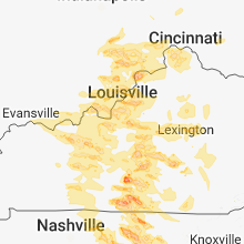
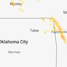
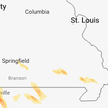
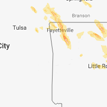
Hail Map for Friday, July 20, 2018

Number of Impacted Households on 7/20/2018
0
Impacted by 1" or Larger Hail
0
Impacted by 1.75" or Larger Hail
0
Impacted by 2.5" or Larger Hail
Square Miles of Populated Area Impacted on 7/20/2018
0
Impacted by 1" or Larger Hail
0
Impacted by 1.75" or Larger Hail
0
Impacted by 2.5" or Larger Hail


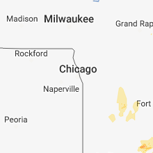

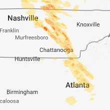
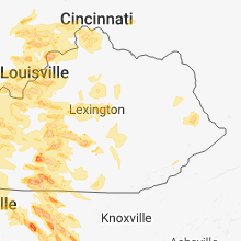

Cities Most Affected by Hail Storms of 7/20/2018
| Hail Size | Demographics of Zip Codes Affected | ||||||
|---|---|---|---|---|---|---|---|
| City | Count | Average | Largest | Pop Density | House Value | Income | Age |
| Louisville, KY | 5 | 1.85 | 2.00 | 2508 | $86k | $33.6k | 37.3 |
| Fayetteville, AR | 3 | 2.17 | 2.75 | 347 | $104k | $31.9k | 27.8 |
| Elkins, AR | 2 | 2.75 | 2.75 | 33 | $68k | $32.1k | 37.3 |
| Coxs Creek, KY | 2 | 2.25 | 2.50 | 74 | $97k | $41.8k | 38.8 |
| Tompkinsville, KY | 1 | 4.00 | 4.00 | 40 | $63k | $22.9k | 42.6 |
| Ulysses, KS | 2 | 1.88 | 2.00 | 11 | $79k | $39.7k | 32.8 |
| Sparta, TN | 2 | 1.75 | 1.75 | 69 | $78k | $29.3k | 42.2 |
| Milton, KY | 1 | 2.75 | 2.75 | 59 | $80k | $38.4k | 40.1 |
| Kings Mountain, KY | 1 | 2.50 | 2.50 | 46 | $39k | $26.5k | 39.0 |
| Leavenworth, IN | 1 | 2.00 | 2.00 | 21 | $65k | $32.1k | 43.9 |
| Madison, IN | 1 | 1.75 | 1.75 | 105 | $89k | $37.7k | 41.1 |
| Palmyra, IN | 1 | 1.75 | 1.75 | 101 | $92k | $41.0k | 39.7 |
| Seymour, IN | 1 | 1.75 | 1.75 | 144 | $89k | $40.7k | 37.7 |
| Beeler, KS | 1 | 1.75 | 1.75 | 1 | $29k | $35.4k | 49.4 |
| Sedgwick, KS | 1 | 1.75 | 1.75 | 26 | $74k | $46.9k | 39.8 |
| Mountain Home, AR | 1 | 1.75 | 1.75 | 133 | $87k | $29.7k | 50.4 |
| Pea Ridge, AR | 1 | 1.75 | 1.75 | 246 | $77k | $36.8k | 32.1 |
| Rogers, AR | 1 | 1.75 | 1.75 | 297 | $93k | $37.4k | 35.4 |
| English, IN | 1 | 1.75 | 1.75 | 24 | $60k | $29.3k | 42.2 |
| Springfield, KY | 1 | 1.75 | 1.75 | 44 | $75k | $33.1k | 40.6 |
| Burkesville, KY | 1 | 1.75 | 1.75 | 20 | $50k | $22.0k | 43.9 |
| Campbellsville, KY | 1 | 1.75 | 1.75 | 99 | $71k | $28.8k | 39.3 |
| Center, KY | 1 | 1.75 | 1.75 | 41 | $28k | $47.9k | 39.0 |
| Columbia, KY | 1 | 1.75 | 1.75 | 48 | $62k | $24.4k | 38.5 |
| Winona, MO | 1 | 1.75 | 1.75 | 9 | $45k | $20.5k | 38.3 |
Hail and Wind Damage Spotted on 7/20/2018
Filter by Report Type:Hail ReportsWind Reports
States Impacted
Missouri, Kentucky, Arkansas, Michigan, Indiana, Ohio, Mississippi, Arizona, Nevada, West Virginia, Kansas, Tennessee, Virginia, North Carolina, Oklahoma, Georgia, AlabamaMissouri
| Local Time | Report Details |
|---|---|
| 7:05 AM CDT | Quarter sized hail reported near Fair Grove, MO, 13.6 miles NNE of Springfield, MO, quarter-sized hail just west and southwest of fair grove. time estimated by radar. |
| 4:52 PM CDT | Quarter sized hail reported near Birch Tree, MO, 44.6 miles S of Salem, MO, quarter size hail at lucky's country store. |
| 5:03 PM CDT | Golf Ball sized hail reported near Winona, MO, 46.3 miles SSE of Salem, MO, observed quarter to some golfball size hail. delayed report. |
| 5:04 PM CDT | Ping Pong Ball sized hail reported near Winona, MO, 48.3 miles SSE of Salem, MO, hail to the size of ping pong balls... not much damage though. relayed via media. |
| 5:19 PM CDT | Storm damage reported in carter county MO, 53.8 miles SE of Salem, MO |
| 5:20 PM CDT | Tree damage and power outages reported throughout the community. corrention for tim in carter county MO, 52 miles SE of Salem, MO |
| 5:33 PM CDT | Tree damage and power outages reported throughout the communit in carter county MO, 52 miles SE of Salem, MO |
| 6:05 PM CDT | Quarter sized hail reported near Essex, MO, 40 miles SSW of Cape Girardeau, MO, quarter size hail reported via media. |
| 6:05 PM CDT | Quarter sized hail reported near Catron, MO, 44.6 miles SSW of Cape Girardeau, MO, quarter size hail reported via media. correction for location. |
| 6:15 PM CDT | Quarter sized hail reported near Broseley, MO, 58.5 miles SW of Cape Girardeau, MO, quarter size hail. relayed through em. |
| 11:17 PM CDT | Half Dollar sized hail reported near Neosho, MO, 66.4 miles WSW of Springfield, MO |
| 11:52 PM CDT | Half Dollar sized hail reported near Joplin, MO, 65.6 miles SE of Chanute, KS |
Kentucky
| Local Time | Report Details |
|---|---|
| 8:10 AM EDT | Trees down on us 25 and interstate 75 near mm 9 in fayette county KY, 24.7 miles NW of Irvine, KY |
| 9:00 AM EDT | A few trees downe in owen county KY, 51 miles SSW of Cincinnati, OH |
| 2:27 PM EDT | Baseball sized hail reported near Milton, KY, 53.3 miles NNE of Louisville, KY |
| 2:28 PM EDT | Half Dollar sized hail reported near Louisville, KY, 13.3 miles NNW of Louisville, KY |
| 2:45 PM EDT | Tree downed at banklick and maher roads. time estimated via rada in kenton county KY, 12.8 miles SSW of Cincinnati, OH |
| 2:45 PM EDT | Hen Egg sized hail reported near Louisville, KY, 13 miles NNW of Louisville, KY |
| 2:46 PM EDT | Golf Ball sized hail reported near Louisville, KY, 15.5 miles NNW of Louisville, KY |
| 2:47 PM EDT | Wires downed on woodward st. time estimated via rada in kenton county KY, 7.4 miles SW of Cincinnati, OH |
| 2:48 PM EDT | Quarter sized hail reported near Louisville, KY, 14 miles N of Louisville, KY, metar ksdf gr 1. |
| 2:50 PM EDT | Golf Ball sized hail reported near Louisville, KY, 14.9 miles N of Louisville, KY, golf ball size hail at churchill downs. |
| 2:50 PM EDT | Golf Ball sized hail reported near Louisville, KY, 12.4 miles NNW of Louisville, KY, large hail in iroquois park. |
| 2:53 PM EDT | Hen Egg sized hail reported near Louisville, KY, 13.3 miles N of Louisville, KY |
| 2:57 PM EDT | Quarter sized hail reported near Louisville, KY, 16 miles N of Louisville, KY, thurston avenue in louisville. |
| 2:57 PM EDT | Report of large maple tree down near south park rd and blue lick r in jefferson county KY, 9.2 miles N of Louisville, KY |
| 3:00 PM EDT | Large tree down on buildin in jefferson county KY, 14.7 miles N of Louisville, KY |
| 3:01 PM EDT | Tree downed at east alexandria pike and dodsworth ln. time estimated via rada in campbell county KY, 7.2 miles SE of Cincinnati, OH |
| 3:02 PM EDT | Quarter sized hail reported near Louisville, KY, 14.6 miles N of Louisville, KY, 4200 block of poplar level road. |
| 3:04 PM EDT | Quarter sized hail reported near Louisville, KY, 16.1 miles NNE of Louisville, KY |
| 3:04 PM EDT | Trees downed. time estimated via rada in kenton county KY, 3.5 miles WSW of Cincinnati, OH |
| 3:10 PM EDT | Eight structures with trees on roofs. power outages also widespread throughout the count in fayette county KY, 43.5 miles NW of Irvine, KY |
| 3:13 PM EDT | Tree downed on wires. time estimated via rada in campbell county KY, 3.9 miles SE of Cincinnati, OH |
| 3:18 PM EDT | Power lines dow in shelby county KY, 31 miles ENE of Louisville, KY |
| 3:20 PM EDT | Trees reported down in greenwood. time estimated from rada in pendleton county KY, 25.4 miles SSE of Cincinnati, OH |
| 3:29 PM EDT | Quarter sized hail reported near Shepherdsville, KY, 3.1 miles E of Louisville, KY |
| 3:40 PM EDT | Multiple trees down around the city... some on power line in franklin county KY, 46.3 miles ENE of Louisville, KY |
| 3:42 PM EDT | Tree down on car with people inside of it. many other trees down in the are in anderson county KY, 42.5 miles E of Louisville, KY |
| 3:45 PM EDT | Franklin county mesone in franklin county KY, 46.5 miles ENE of Louisville, KY |
| 3:50 PM EDT | Several trees down reported in mckinneysburg. time estimated from radar. corrected for tim in pendleton county KY, 37.2 miles SSE of Cincinnati, OH |
| 3:52 PM EDT | Tree down on jonesville road. time estimated from radar. corrected for tim in grant county KY, 32.6 miles SSW of Cincinnati, OH |
| 3:52 PM EDT | Trees down near mccracken pike and steele roa in woodford county KY, 51.1 miles E of Louisville, KY |
| 3:52 PM EDT | Tennis Ball sized hail reported near Coxs Creek, KY, 12.2 miles ESE of Louisville, KY |
| 3:53 PM EDT | Several trees down reported in mckinneysburg. time estimated from rada in pendleton county KY, 37.2 miles SSE of Cincinnati, OH |
| 3:54 PM EDT | Hen Egg sized hail reported near Coxs Creek, KY, 14.8 miles ESE of Louisville, KY |
| 3:57 PM EDT | Tree down on jonesville road. time estimated from rada in grant county KY, 32.6 miles SSW of Cincinnati, OH |
| 3:59 PM EDT | Measured at blue grass airpor in fayette county KY, 41.5 miles NW of Irvine, KY |
| 3:59 PM EDT | Large trees dow in woodford county KY, 47.8 miles WNW of Irvine, KY |
| 4:01 PM EDT | Large trees down along midway roa in woodford county KY, 48.7 miles NW of Irvine, KY |
| 4:02 PM EDT | Tree on a home in venice par in fayette county KY, 37.1 miles NW of Irvine, KY |
| 4:05 PM EDT | Tree on a house... rose and maxwel in fayette county KY, 37.1 miles NW of Irvine, KY |
| 4:05 PM EDT | Tree down across malibu driv in fayette county KY, 36.3 miles NW of Irvine, KY |
| 4:06 PM EDT | Measured at blue grass airpor in fayette county KY, 41.5 miles NW of Irvine, KY |
| 4:07 PM EDT | Tree downed on leslie driv in fayette county KY, 37.4 miles NW of Irvine, KY |
| 4:24 PM EDT | Tree branches sheared 6 ft above groun in fayette county KY, 38.9 miles WNW of Irvine, KY |
| 4:30 PM EDT | Multiple trees down from strong wind in jessamine county KY, 40.2 miles WNW of Irvine, KY |
| 4:31 PM EDT | Multiple trees downed. damage to a barn as well as roofs of other outbuildings near the intersection of highway 460 and chiles highwa in montgomery county KY, 28.5 miles N of Irvine, KY |
| 4:55 PM EDT | Kentucky mesonet station measured 62 mph wind gus in bath county KY, 28.7 miles NNE of Irvine, KY |
| 4:57 PM EDT | A large limb and a tree were blown dow in powell county KY, 13.5 miles NE of Irvine, KY |
| 5:07 PM EDT | Widespread tree damage along burgin roa in mercer county KY, 46.5 miles W of Irvine, KY |
| 5:10 PM EDT | Trees down along highway 80 in rowan county KY, 38.2 miles NE of Irvine, KY |
| 5:18 PM EDT | Tree down on highway 77 in morgan county KY, 37.5 miles ENE of Irvine, KY |
| 5:18 PM EDT | Trees dow in madison county KY, 22.4 miles WNW of Irvine, KY |
| 5:19 PM EDT | Tree down on greasy creek r in morgan county KY, 38.9 miles ENE of Irvine, KY |
| 5:20 PM EDT | Tree down on highway 71 in morgan county KY, 43.8 miles ENE of Irvine, KY |
| 5:23 PM EDT | Tree down on mcclain wa in morgan county KY, 41.2 miles ENE of Irvine, KY |
| 5:23 PM EDT | Tree down on highway 7 about 4 miles from west libert in morgan county KY, 42.8 miles ENE of Irvine, KY |
| 5:35 PM EDT | A tree was blown down in the conrad estates communit in estill county KY, 4.1 miles W of Irvine, KY |
| 5:39 PM EDT | Trees down on winston roa in estill county KY, 5.8 miles W of Irvine, KY |
| 5:40 PM EDT | A tree was blown dow in estill county KY, 7.5 miles ESE of Irvine, KY |
| 5:45 PM EDT | Multiple trees and wires reported down in boyd county as indicated on local morning news in boyd county KY, 61.4 miles W of Charleston, WV |
| 6:15 PM EDT | Half Dollar sized hail reported near Loretto, KY, 29.6 miles SE of Louisville, KY |
| 6:22 PM EDT | Quarter sized hail reported near Liberty, KY, 53.7 miles SE of Louisville, KY |
| 6:22 PM EDT | Quarter sized hail reported near Hustonville, KY, 53.2 miles SE of Louisville, KY |
| 5:24 PM CDT | Quarter sized hail reported near Knob Lick, KY, 62.6 miles S of Louisville, KY |
| 5:29 PM CDT | Golf Ball sized hail reported near Center, KY, 61.4 miles S of Louisville, KY, viewer reports golf ball size hail near sulphur well. |
| 6:30 PM EDT | Golf Ball sized hail reported near Springfield, KY, 32.3 miles SE of Louisville, KY, golf ball size hail along highway 152. |
| 6:33 PM EDT | Trees down at bardstown road and highway 15 in washington county KY, 32.3 miles SE of Louisville, KY |
| 5:39 PM CDT | Fire chief reports trees... power lines down and shop destroyed near edmonton along highway 496. highway 496 closed due to debri in metcalfe county KY, 69.7 miles S of Louisville, KY |
| 6:43 PM EDT | Ping Pong Ball sized hail reported near Campbellsville, KY, 41.6 miles SSE of Louisville, KY, in the mac community. |
| 6:47 PM EDT | Quarter sized hail reported near Elk Horn, KY, 52.2 miles SSE of Louisville, KY |
| 6:49 PM EDT | Storm damage reported in taylor county KY, 49.2 miles SSE of Louisville, KY |
| 6:49 PM EDT | Trees blocking the road on n ky 50 in casey county KY, 52.7 miles WSW of Irvine, KY |
| 6:54 PM EDT | Tennis Ball sized hail reported near Kings Mountain, KY, 51.9 miles WSW of Irvine, KY |
| 6:57 PM EDT | Quarter sized hail reported near Lebanon, KY, 43.6 miles SE of Louisville, KY, near bradfordsville. |
| 5:59 PM CDT | Quarter sized hail reported near Tompkinsville, KY, 74.3 miles NE of Nashville, TN |
| 7:00 PM EDT | Golf Ball sized hail reported near Campbellsville, KY, 45.9 miles SSE of Louisville, KY |
| 7:00 PM EDT | Tree down on highway 587 near grayhaw in jackson county KY, 19.4 miles S of Irvine, KY |
| 6:01 PM CDT | Ping Pong Ball sized hail reported near Columbia, KY, 64.7 miles SSE of Louisville, KY |
| 7:15 PM EDT | Tree down on turkey creek roa in pike county KY, 59.5 miles SW of Charleston, WV |
| 7:19 PM EDT | Quarter sized hail reported near Campbellsville, KY, 51.1 miles SSE of Louisville, KY |
| 6:19 PM CDT | Golf Ball sized hail reported near Columbia, KY, 67.4 miles SSE of Louisville, KY, viewer report of hail a little larger than golf ball size near columbia. |
| 6:30 PM CDT | Golf Ball sized hail reported near Burkesville, KY, 82.4 miles S of Louisville, KY |
| 7:42 PM EDT | Trees down on highway 100 in rockcastle county KY, 30 miles SW of Irvine, KY |
| 7:42 PM EDT | Quarter sized hail reported near Crestwood, KY, 30.2 miles NNE of Louisville, KY |
| 7:45 PM EDT | Reported at 7511 hwy 329 crestwood trees and powerlines dow in oldham county KY, 28.3 miles NNE of Louisville, KY |
| 6:54 PM CDT | Grapefruit sized hail reported near Tompkinsville, KY, 70.9 miles ENE of Nashville, TN, verified photo on twitter. time estimated from radar. |
| 7:00 PM CDT | Quarter sized hail reported near Tompkinsville, KY, 70.9 miles ENE of Nashville, TN, reported at tompkinsville. |
| 7:10 PM CDT | Quarter sized hail reported near Columbia, KY, 65.6 miles SSE of Louisville, KY |
| 8:10 PM EDT | Tree on a house at alton rd and sherrin ave in st. matthew in jefferson county KY, 17.9 miles NNE of Louisville, KY |
| 8:10 PM EDT | Trees down on keavy roa in laurel county KY, 45.4 miles S of Irvine, KY |
| 8:13 PM EDT | Trees down on highway 55 in laurel county KY, 47.3 miles S of Irvine, KY |
| 7:16 PM CDT | Quarter sized hail reported near Fulton, KY, 37.6 miles NW of Mc Kenzie, TN |
| 7:16 PM CDT | Quarter sized hail reported near Fulton, KY, 39.3 miles NW of Mc Kenzie, TN |
| 8:33 PM EDT | Tree down on power line in monticell in wayne county KY, 76.4 miles SW of Irvine, KY |
| 8:44 PM EDT | Trees down on highway 20 in whitley county KY, 61.3 miles NNW of Knoxville, TN |
| 8:52 PM EDT | Trees down on highway 22 in bell county KY, 58.8 miles NNE of Knoxville, TN |
| 8:52 PM EDT | Trees down in pinevill in bell county KY, 56.5 miles NNE of Knoxville, TN |
| 8:57 PM EDT | Trees down on highway 90 in whitley county KY, 53.7 miles N of Knoxville, TN |
| 9:01 PM EDT | Quarter sized hail reported near Louisville, KY, 11.4 miles NW of Louisville, KY |
| 9:08 PM EDT | Trees down on highway 421 near harla in harlan county KY, 63.7 miles WNW of Bristol, TN |
| 9:13 PM EDT | Trees down on highway 300 in harlan county KY, 60.1 miles WNW of Bristol, TN |
| 9:13 PM EDT | Trees down on highway 99 in harlan county KY, 59.1 miles WNW of Bristol, TN |
| 9:40 PM EDT | Storm damage reported in jefferson county KY, 17 miles N of Louisville, KY |
| 9:41 PM EDT | Quarter sized hail reported near Louisville, KY, 8.1 miles NNE of Louisville, KY |
| 9:45 PM EDT | Quarter sized hail reported near Louisville, KY, 23.7 miles NNE of Louisville, KY, also saw tree branches and leaves down. |
| 9:45 PM EDT | Quarter sized hail reported near Louisville, KY, 23.9 miles NNE of Louisville, KY |
| 8:45 PM CDT | Quarter sized hail reported near Mc Daniels, KY, 47.3 miles SW of Louisville, KY |
| 9:50 PM EDT | Quarter sized hail reported near Louisville, KY, 23.1 miles NNE of Louisville, KY |
| 9:59 PM CDT | Hart county fire department reported trees down around the intersection of 728 and campground roa in hart county KY, 43.7 miles SSW of Louisville, KY |
| 10:50 PM CDT | Quarter sized hail reported near Greensburg, KY, 56.6 miles S of Louisville, KY, corrects previous hail report from 1 nne exie. |
| 11:18 PM CDT | Quarter sized hail reported near Greensburg, KY, 56.6 miles S of Louisville, KY |
| 12:10 AM CDT | Viewer-relayed report of tree down on car on east front street. time estimated based on rada in barren county KY, 68.9 miles S of Louisville, KY |
Arkansas
| Local Time | Report Details |
|---|---|
| 8:09 AM CDT | Golf Ball sized hail reported near Mountain Home, AR, 78.4 miles SE of Springfield, MO, heavy hail was falling in mountain home... ranging from nickel to golfball size. |
| 8:11 AM CDT | Quarter sized hail reported near Mountain Home, AR, 84.3 miles SE of Springfield, MO |
| 8:54 AM CDT | Storm damage reported in izard county AR, 88.5 miles NNE of Little Rock, AR |
| 8:54 AM CDT | Storm damage reported in izard county AR, 88.5 miles NNE of Little Rock, AR |
| 8:56 AM CDT | Storm damage reported in fulton county AR, 93.6 miles SSW of Salem, MO |
| 8:56 AM CDT | Storm damage reported in izard county AR, 90.7 miles NNE of Little Rock, AR |
| 8:56 AM CDT | Storm damage reported in izard county AR, 90.7 miles NNE of Little Rock, AR |
| 9:10 AM CDT | Power lines were blown down... and roof damage occurred in town. the report was relayed via newport as in independence county AR, 79.5 miles NNE of Little Rock, AR |
| 9:35 AM CDT | Trees were blown down... and a vehicle was damage in white county AR, 53 miles NNE of Little Rock, AR |
| 9:20 PM CDT | Em reports numerous trees and power lines down in the city of clarendon. the entire city was without powe in monroe county AR, 55 miles E of Little Rock, AR |
| 9:30 PM CDT | Quarter sized hail reported near Jacksonville, AR, 11.7 miles NE of Little Rock, AR |
| 9:40 PM CDT | Half Dollar sized hail reported near Sherwood, AR, 10.2 miles NNE of Little Rock, AR |
| 9:40 PM CDT | Quarter sized hail reported near Sherwood, AR, 9.9 miles NNE of Little Rock, AR |
| 9:40 PM CDT | Em reported a number of trees and power lines were blown down in and around ul in prairie county AR, 47.8 miles ESE of Little Rock, AR |
| 9:57 PM CDT | Em reported numerous trees and power lines were blown down in the are in arkansas county AR, 55.7 miles ESE of Little Rock, AR |
| 10:00 PM CDT | Considerable tree and power line damage occurred near the intersection of highways 33 and 153 west of crocketts bluf in arkansas county AR, 57.6 miles ESE of Little Rock, AR |
| 10:15 PM CDT | Em reported a tree fell onto a mobile home. no injuries were reporte in arkansas county AR, 68.8 miles ESE of Little Rock, AR |
| 10:25 PM CDT | Numerous trees and power lines were blown down along highway 17 near ethe in arkansas county AR, 71 miles ESE of Little Rock, AR |
| 10:26 PM CDT | Quarter sized hail reported near North Little Rock, AR, 3 miles NNE of Little Rock, AR, quarter sized hail fell at the nws office at the north little rock airport. |
| 10:30 PM CDT | Quarter sized hail reported near North Little Rock, AR, 3 miles NNE of Little Rock, AR |
| 11:57 PM CDT | Golf Ball sized hail reported near Pea Ridge, AR, 69.3 miles SW of Springfield, MO |
| 11:57 PM CDT | Trees down on highway 72 in pea ridge in benton county AR, 69.3 miles SW of Springfield, MO |
| 12:04 AM CDT | Half Dollar sized hail reported near Pea Ridge, AR, 69.8 miles SW of Springfield, MO |
| 12:04 AM CDT | Half Dollar sized hail reported near Rogers, AR, 69.6 miles NNE of Fort Smith, AR, hail up to half dollar size reported in little flock. |
| 12:07 AM CDT | Golf Ball sized hail reported near Rogers, AR, 67.3 miles NNE of Fort Smith, AR |
| 12:07 AM CDT | Trees down in rogers in benton county AR, 67.3 miles NNE of Fort Smith, AR |
| 12:07 AM CDT | Trees and power lines down in urbanette in carroll county AR, 56 miles SSW of Springfield, MO |
| 12:17 AM CDT | Quarter sized hail reported near Lowell, AR, 61.6 miles NNE of Fort Smith, AR |
| 12:19 AM CDT | Half Dollar sized hail reported near Lowell, AR, 62.5 miles NNE of Fort Smith, AR |
| 12:21 AM CDT | Quarter sized hail reported near Springdale, AR, 60.5 miles NNE of Fort Smith, AR, quarter hail reported in bethel heights |
| 12:21 AM CDT | Quarter sized hail reported near Springdale, AR, 57.9 miles NNE of Fort Smith, AR |
| 12:25 AM CDT | Quarter sized hail reported near Lonoke, AR, 24.4 miles ENE of Little Rock, AR |
| 12:27 AM CDT | Golf Ball sized hail reported near Fayetteville, AR, 53.9 miles NNE of Fort Smith, AR, golf ball hail reported near lake fayetteville |
| 12:30 AM CDT | Quarter sized hail reported near Fayetteville, AR, 54.3 miles NNE of Fort Smith, AR |
| 12:39 AM CDT | Large tree down on highway 1 in washington county AR, 48.3 miles NNE of Fort Smith, AR |
| 12:44 AM CDT | Storm damage reported in washington county AR, 48.9 miles NNE of Fort Smith, AR |
| 12:44 AM CDT | Quarter sized hail reported near Elkins, AR, 48.9 miles NNE of Fort Smith, AR |
| 12:45 AM CDT | Quarter sized hail reported near Elkins, AR, 48.3 miles NNE of Fort Smith, AR, quarter hail reported just west of elkins on highway 16. |
| 12:47 AM CDT | Baseball sized hail reported near Elkins, AR, 48.3 miles NNE of Fort Smith, AR, baseball hail east side of elkins. reports of broken car windshields. |
| 12:52 AM CDT | Half Dollar sized hail reported near Rogers, AR, 69.6 miles NNE of Fort Smith, AR, hail up to half dollar size reported in little flock. |
| 12:54 AM CDT | Baseball sized hail reported near Fayetteville, AR, 46.2 miles NNE of Fort Smith, AR, roof damage to a home on brannon mountain road. |
| 12:57 AM CDT | Hen Egg sized hail reported near Fayetteville, AR, 45.7 miles NE of Fort Smith, AR, severe hail reported at thompsons cut |
| 1:04 AM CDT | Baseball sized hail reported near Elkins, AR, 44.1 miles NE of Fort Smith, AR |
| 1:44 AM CDT | Quarter sized hail reported near Gravette, AR, 71.4 miles N of Fort Smith, AR |
| 1:45 AM CDT | Quarter sized hail reported near Searcy, AR, 45.8 miles NE of Little Rock, AR |
| 1:48 AM CDT | Half Dollar sized hail reported near Gravette, AR, 71.4 miles N of Fort Smith, AR |
| 1:48 AM CDT | Trees and power lines down in urbanette in carroll county AR, 56 miles SSW of Springfield, MO |
| 2:30 AM CDT | Numerous trees blown down. preliminary reports of roof damage to several building in pope county AR, 60.8 miles NW of Little Rock, AR |
| 2:35 AM CDT | Reported by the asos observing site at the russellville airpor in pope county AR, 58.2 miles NW of Little Rock, AR |
| 2:45 AM CDT | Near timberlake reservoir... approximately 13 trees lost with numerous large limbs blown great distances. a pool house sustained significant damage from felled tree in conway county AR, 38 miles NW of Little Rock, AR |
| 2:54 AM CDT | Trained spotter estimated wind gusts of at least 60 mp in conway county AR, 37.6 miles NW of Little Rock, AR |
| 3:00 AM CDT | Trained spotter reported numerous trees and power lines blown down. several buildings sustained minor roof damag in conway county AR, 37.6 miles NW of Little Rock, AR |
| 3:25 AM CDT | Several large trees were blown dow in pulaski county AR, 11.1 miles W of Little Rock, AR |
| 3:26 AM CDT | Extensive tree damage and power lines down in the vicinity of waldenwood lane and denny road. roof damage reported to several homes... along with chimney damag in pulaski county AR, 13.6 miles W of Little Rock, AR |
| 3:34 AM CDT | Numerous large limbs and powerlines down in the 7400 block of arch stree in pulaski county AR, 7.5 miles SW of Little Rock, AR |
| 3:38 AM CDT | Several large trees were blown dow in saline county AR, 12.6 miles SSW of Little Rock, AR |
| 4:36 AM CDT | A power pole was blown dow in pope county AR, 51.1 miles NW of Little Rock, AR |
Michigan
| Local Time | Report Details |
|---|---|
| 10:00 AM EDT | Many trees reported down around this locatio in kalamazoo county MI, 47.8 miles S of Grand Rapids, MI |
Indiana
| Local Time | Report Details |
|---|---|
| 11:40 AM CDT | *** 1 inj *** tree down on car. at least 1 injured. time estimated from rada in la porte county IN, 40.7 miles ESE of Chicago, IL |
| 1:21 PM EDT | Hen Egg sized hail reported near Leavenworth, IN, 39.5 miles WNW of Louisville, KY |
| 1:22 PM EDT | Golf Ball sized hail reported near English, IN, 44.3 miles WNW of Louisville, KY |
| 1:28 PM EDT | Half Dollar sized hail reported near Leavenworth, IN, 37.5 miles WNW of Louisville, KY |
| 1:53 PM EDT | Corn flattened and barn damaged. time estimated from rada in marshall county IN, 62.3 miles WNW of Fort Wayne, IN |
| 2:02 PM EDT | Quarter sized hail reported near Seymour, IN, 58.1 miles SSE of Indianapolis, IN, time estimated by radar. |
| 2:05 PM EDT | Tree down across the road. time estimated via rada in marshall county IN, 55.4 miles WNW of Fort Wayne, IN |
| 2:06 PM EDT | Tree limbs down... barn damage... grain bin damaged and corn flattened down. time estimated from rada in kosciusko county IN, 51.5 miles WNW of Fort Wayne, IN |
| 2:10 PM EDT | Several trees down along mt pleasant road. ime estimated by rada in dearborn county IN, 21.8 miles WNW of Cincinnati, OH |
| 2:15 PM EDT | Barn and roof damage. time estimated from rada in elkhart county IN, 53.6 miles WNW of Fort Wayne, IN |
| 2:20 PM EDT | Golf Ball sized hail reported near Seymour, IN, 61.1 miles N of Louisville, KY |
| 2:25 PM EDT | Several trees dow in kosciusko county IN, 44.5 miles W of Fort Wayne, IN |
| 2:28 PM EDT | Golf Ball sized hail reported near Madison, IN, 53.5 miles WSW of Cincinnati, OH, jefferson county dispatch reports golf ball size hail at their location. |
| 2:29 PM EDT | Ping Pong Ball sized hail reported near Madison, IN, 52.9 miles WSW of Cincinnati, OH |
| 2:35 PM EDT | 3 power poles snapped and transformer down in road. time estimated via rada in kosciusko county IN, 46 miles WNW of Fort Wayne, IN |
| 2:36 PM EDT | Several trees down. time estimated from rada in kosciusko county IN, 45.5 miles W of Fort Wayne, IN |
| 2:40 PM EDT | Tree fell on power line near 2nd street. time estimated from rada in ohio county IN, 22 miles WSW of Cincinnati, OH |
| 2:40 PM EDT | Quarter sized hail reported near Madison, IN, 46.2 miles WSW of Cincinnati, OH, several trees have also been reported downed throughout ripley county. |
| 2:48 PM EDT | Power lines dow in jefferson county IN, 56.5 miles WSW of Cincinnati, OH |
| 3:06 PM EDT | Broken utility pole. time estimated from rada in madison county IN, 36.6 miles NNE of Indianapolis, IN |
| 3:10 PM EDT | Large tree blocking enterprise roa in switzerland county IN, 30.7 miles WSW of Cincinnati, OH |
| 3:13 PM EDT | Numerous trees down throughout switzerland count in switzerland county IN, 32.8 miles SW of Cincinnati, OH |
| 3:15 PM EDT | Tree blown down onto house. time estimated from rada in madison county IN, 42.2 miles NE of Indianapolis, IN |
| 3:22 PM EDT | Quarter sized hail reported near Wabash, IN, 37.8 miles SW of Fort Wayne, IN, lasted for 30 seconds. |
| 3:35 PM EDT | Large limb came down on power lines at noble cty fairground in noble county IN, 26.5 miles NNW of Fort Wayne, IN |
| 3:37 PM EDT | Barn damage. time is very roughly estimated from rada in madison county IN, 38 miles NE of Indianapolis, IN |
| 3:37 PM EDT | Barn damage near moonville. time is very roughly estimated from radar. report received by em at 1609 ed in madison county IN, 41.8 miles NE of Indianapolis, IN |
| 3:37 PM EDT | Barn damage near moonville. time is very roughly estimated from radar. report received by em at 1609 ed in madison county IN, 41.8 miles NE of Indianapolis, IN |
| 3:37 PM EDT | Barn damage near moonville. time is very roughly estimated from radar. report received by em at 1609 ed in madison county IN, 41.8 miles NE of Indianapolis, IN |
| 3:39 PM EDT | 1"-1.25 " tree branches down. minor street floodin in huntington county IN, 25.4 miles WSW of Fort Wayne, IN |
| 4:00 PM EDT | 13" tree down... several tree limbs snappe in wells county IN, 19.7 miles S of Fort Wayne, IN |
| 4:00 PM EDT | Some shingle damage on roof near 700n and 600e. crop damage also note in wells county IN, 15.6 miles S of Fort Wayne, IN |
| 4:20 PM EDT | Tree down. tree did not appear health in blackford county IN, 45.4 miles SSW of Fort Wayne, IN |
| 5:16 PM EDT | Large tree limb down near intersection of west cardinal drive and jackson street. time very roughly estimated from rada in delaware county IN, 48.1 miles NE of Indianapolis, IN |
| 5:16 PM EDT | Shelby county sheriff dept is on scene with trees downs on 900 s in the 1000 to 2000 block west. trees are large enough to require chainsaws for removal. power lines ar in shelby county IN, 32.7 miles SE of Indianapolis, IN |
| 5:17 PM EDT | Quarter sized hail reported near Muncie, IN, 48.5 miles NE of Indianapolis, IN |
| 5:32 PM EDT | Half Dollar sized hail reported near Holton, IN, 47.1 miles W of Cincinnati, OH, holton fire department reported half dollar sized hail. time estimated via radar. |
| 7:26 PM EDT | Listener reports trees down at us 31 and brownstown road north of henryvill in clark county IN, 39.5 miles N of Louisville, KY |
| 8:10 PM EDT | Quarter sized hail reported near Leavenworth, IN, 39.1 miles WNW of Louisville, KY |
| 8:10 PM EDT | Quarter sized hail reported near English, IN, 40.1 miles WNW of Louisville, KY |
| 8:10 PM EDT | Quarter sized hail reported near English, IN, 40.4 miles WNW of Louisville, KY |
| 8:28 PM EDT | Quarter sized hail reported near Clarksville, IN, 23.1 miles N of Louisville, KY |
| 9:19 PM EDT | Golf Ball sized hail reported near Palmyra, IN, 34 miles NW of Louisville, KY, golf ball size hail along hancock chapel road. |
| 10:06 PM CDT | Several trees and powerlines down. a tree fell on a mobile home in spencer county IN, 19.5 miles ESE of Evansville, IN |
Ohio
| Local Time | Report Details |
|---|---|
| 1:17 PM EDT | Tree downed and basketball hoop damaged. time estimated via rada in darke county OH, 69.9 miles SSE of Fort Wayne, IN |
| 2:51 PM EDT | Via social media. large tree fell on 4 cars. time estimated from radar. corrected for 1 non life threatening injury. *** 1 inj *** in hamilton county OH, 4.7 miles NE of Cincinnati, OH |
| 2:51 PM EDT | Via social media. large tree fell on 4 cars. time estimated from radar. corrected for 1 non life threatening injury. *** 1 inj *** in hamilton county OH, 4.7 miles NE of Cincinnati, OH |
| 3:20 PM EDT | 6 plus inch branches snapping off tree in clermont county OH, 16.2 miles ESE of Cincinnati, OH |
| 5:02 PM EDT | Large tree down on 8th street in scioto county OH, 78 miles WNW of Charleston, WV |
Mississippi
| Local Time | Report Details |
|---|---|
| 12:54 PM CDT | A few power lines down... tree on a hous in sunflower county MS, 100.9 miles NNW of Jackson, MS |
| 1:48 PM CDT | Power line dow in holmes county MS, 60.8 miles N of Jackson, MS |
| 1:48 PM CDT | Power line dow in holmes county MS, 60.8 miles N of Jackson, MS |
| 2:02 PM CDT | Tree down along hwy 12 in holmes county MS, 56.4 miles N of Jackson, MS |
| 12:00 AM CDT | Tree down partially blocking highway 1. reported by sheriff's offic in bolivar county MS, 94.1 miles SE of Little Rock, AR |
| 4:35 AM CDT | Measured at cleveland asos krn in bolivar county MS, 95.1 miles NE of Bastrop, LA |
| 5:11 AM CDT | Tree downed across jones bayou roa in bolivar county MS, 93 miles NE of Bastrop, LA |
| 5:20 AM CDT | Tree downed on power lines at 400 mimosa drive in downtown indianol in sunflower county MS, 84.1 miles NNW of Jackson, MS |
Arizona
| Local Time | Report Details |
|---|---|
| 2:00 PM MST | Quarter sized hail reported near Vail, AZ, 24.5 miles SSE of Tucson, AZ |
| 4:20 PM MST | Quarter sized hail reported near Cochise, AZ, 53.1 miles NNW of Douglas, AZ, spotter 3096 reported quarter size hail. |
| 4:40 PM MST | Quarter sized hail reported near Hereford, AZ, 38.9 miles W of Douglas, AZ, spotter 903 reported roughly quarter size hail. |
| 4:55 PM MST | Quarter sized hail reported near Hereford, AZ, 40.2 miles W of Douglas, AZ, spotter 926 reported heavy rain and up to 1" hail. |
| 5:29 PM MST | Quarter sized hail reported near Sierra Vista, AZ, 43 miles WNW of Douglas, AZ, spotter #911 in sierra vista reports hail now up to 1" in diameter. |
| 5:34 PM MST | Quarter sized hail reported near Sierra Vista, AZ, 45.3 miles WNW of Douglas, AZ, report via cocorahs estimated quarter size hail. |
| 5:35 PM MST | Quarter sized hail reported near Sierra Vista, AZ, 44.3 miles WNW of Douglas, AZ, spotter #3108 in sierra vista had dime to quarter size hail for 8 minutes. |
| 5:36 PM MST | Quarter sized hail reported near Sierra Vista, AZ, 43.8 miles WNW of Douglas, AZ, spotter 322 estimated nickel to quarter size hail falling for roughly 3-4 minutes. |
| 5:38 PM MST | Quarter sized hail reported near Sierra Vista, AZ, 43.9 miles WNW of Douglas, AZ, spotter 374 estimated quarter size hail. |
| 5:40 PM MST | Quarter sized hail reported near Sierra Vista, AZ, 44.3 miles WNW of Douglas, AZ, spotter 905 estimated quarter size hail. |
Nevada
| Local Time | Report Details |
|---|---|
| 2:55 PM PDT | Borax railroad mesonet up183 recorded sustained winds of 62 mph and gusts to 75 mp in clark county NV, 37.4 miles SSW of Las Vegas, NV |
| 6:58 PM PDT | Corrects previous tstm wnd dmg report from 1 s green valley. public report of a concrete slab pulled up by an uprooted tree in a grocery store parking lot off of green in clark county NV, 10.3 miles SSE of Las Vegas, NV |
| 6:58 PM PDT | Corrects previous tstm wnd dmg report from 3 nne henderson executive airport. report of 15 trees down along st. rose parkway and eastern ave. vehicle damage also report in clark county NV, 11.3 miles S of Las Vegas, NV |
| 6:58 PM PDT | Corrects previous tstm wnd dmg report from 1 wsw green valley. corrects previous tstm wnd dmg report from 1 wsw green valley. public reported a large tree dow in clark county NV, 10 miles SSE of Las Vegas, NV |
| 6:58 PM PDT | Corrects previous tstm wnd dmg report from 2 nnw anthem. public report of significant damage to large shopping center sig in clark county NV, 12 miles S of Las Vegas, NV |
| 6:58 PM PDT | Corrects previous tstm wnd dmg report from 2 ssw green valley. green valley ranch casino reported multiple large trees downe in clark county NV, 10.8 miles SSE of Las Vegas, NV |
| 6:59 PM PDT | Corrects previous tstm wnd dmg report from 2 s green valley. public report mentions at least 8 trees uproote in clark county NV, 11 miles SSE of Las Vegas, NV |
| 7:00 PM PDT | Wind gust reported at 68 mph in henderso in clark county NV, 12.6 miles S of Las Vegas, NV |
| 7:01 PM PDT | Corrects previous tstm wnd dmg report from 2 s green valley. henderson pavilion received significant wind damag in clark county NV, 11 miles SSE of Las Vegas, NV |
| 7:02 PM PDT | Corrects previous tstm wnd dmg report from 3 nne henderson executive airport. public twitter reported significant vehicle damag in clark county NV, 11.2 miles S of Las Vegas, NV |
| 7:03 PM PDT | Corrects previous tstm wnd dmg report from 3 nne henderson executive airport. public tweet reported a downed tree causing significant vehicle damag in clark county NV, 11.2 miles S of Las Vegas, NV |
| 7:05 PM PDT | Nv energy reported 6 downed power poles between green valley parkway and e sunset r in clark county NV, 7.8 miles SSE of Las Vegas, NV |
| 7:07 PM PDT | Media reported downed power lines on w sunset rd. between arroyo grande and valle verd in clark county NV, 8.9 miles SSE of Las Vegas, NV |
| 7:08 PM PDT | Corrects previous tstm wnd gst report from 1 sse green valley. mesonet recorded a wind gust of 71 mp in clark county NV, 11 miles SSE of Las Vegas, NV |
| 7:08 PM PDT | Tree downed on the corner of eastern ave and e serene av in clark county NV, 10.5 miles S of Las Vegas, NV |
| 7:09 PM PDT | Corrects previous tstm wnd dmg report from 2 nne henderson executive airport. multiple trees downed near seven hills drive and w horizon ridge pkw in clark county NV, 12.6 miles S of Las Vegas, NV |
| 7:13 PM PDT | Corrects previous tstm wnd gst report from 1 sse green valley. corrects previous tstm wnd gst report from 1 sse green valley. mesonet site reported 61 mph wind gust in clark county NV, 11 miles SSE of Las Vegas, NV |
| 7:14 PM PDT | Corrects previous tstm wnd dmg report from 3 nne henderson executive airport. corrects previous tstm wnd dmg report from 3 nne henderson executive airport. public repor in clark county NV, 11.2 miles S of Las Vegas, NV |
| 7:15 PM PDT | Corrects previous tstm wnd dmg report from 2 s green valley. corrects previous tstm wnd dmg report from 2 s green valley. henderson pavilion received significant wind d in clark county NV, 11 miles SSE of Las Vegas, NV |
| 7:15 PM PDT | Corrects previous tstm wnd dmg report from 2 wsw green valley. media reported a downed tree in pebble park. time indicated from rada in clark county NV, 9.8 miles S of Las Vegas, NV |
| 7:16 PM PDT | Corrects previous tstm wnd dmg report from 3 ne henderson executive airport. tree downed and damage to garage door reported on s eastern ave and coronado center d in clark county NV, 12 miles S of Las Vegas, NV |
| 7:16 PM PDT | Corrects previous tstm wnd dmg report from 3 nne henderson executive airport. corrects previous tstm wnd dmg report from 3 nne henderson executive airport. public repor in clark county NV, 11.2 miles S of Las Vegas, NV |
| 7:18 PM PDT | Corrects previous tstm wnd dmg report from 1 s anthem. public reported multiple trees downed in sun city anthe in clark county NV, 14.8 miles S of Las Vegas, NV |
| 7:19 PM PDT | Corrects previous tstm wnd gst report from 1 sse green valley. mesonet site reported 61 mph wind gust in clark county NV, 11 miles SSE of Las Vegas, NV |
| 7:20 PM PDT | Tree downed and damage to garage door reported on s eastern ave and coronado center d in clark county NV, 12 miles S of Las Vegas, NV |
| 7:20 PM PDT | Corrects previous tstm wnd dmg report from 3 nne henderson executive airport. public report of tree downed and blocking two right lanes of s eastern blv in clark county NV, 11.2 miles S of Las Vegas, NV |
| 7:58 PM PDT | Media reported via twitter a large downed tree in pebble park. time indicated from rada in clark county NV, 9.8 miles S of Las Vegas, NV |
| 7:58 PM PDT | Multiple trees downed near seven hills drive and w horizon ridge pkw in clark county NV, 12.6 miles S of Las Vegas, NV |
| 7:58 PM PDT | Public twitter reported multiple trees downed in sun city anthe in clark county NV, 14.8 miles S of Las Vegas, NV |
| 7:58 PM PDT | Green valley ranch casino reported multiple large trees downed from the win in clark county NV, 10.8 miles SSE of Las Vegas, NV |
| 8:02 PM PDT | Twitter report mentions at least 8 trees uproote in clark county NV, 11 miles SSE of Las Vegas, NV |
| 8:05 PM PDT | Twitter report of tree downed and blocking two right lanes of s eastern blv in clark county NV, 11.2 miles S of Las Vegas, NV |
| 8:14 PM PDT | Public twitter reports significant damage to large shopping center sig in clark county NV, 12 miles S of Las Vegas, NV |
| 8:26 PM PDT | Public tweet reported a downed tree causing significant vehicle damag in clark county NV, 11.2 miles S of Las Vegas, NV |
| 8:26 PM PDT | Public tweet reported a downed tree causing significant vehicle damag in clark county NV, 11.2 miles S of Las Vegas, NV |
| 8:28 PM PDT | Public twitter reported a large tree dow in clark county NV, 10 miles SSE of Las Vegas, NV |
| 8:54 PM PDT | Henderson pavilion received some wind damag in clark county NV, 11 miles SSE of Las Vegas, NV |
West Virginia
| Local Time | Report Details |
|---|---|
| 6:21 PM EDT | Tree down across sheridan road in lincoln county WV, 28.5 miles W of Charleston, WV |
| 6:38 PM EDT | Tree down across ten mile road near route 10 in lincoln county WV, 36.3 miles WSW of Charleston, WV |
| 6:50 PM EDT | Tree down across bark camp road in alkol in lincoln county WV, 20.1 miles SW of Charleston, WV |
| 6:50 PM EDT | Very large tree limbs down and blocked 8th avenue in st. albans. smaller limbs and branches down all along 8th avenu in kanawha county WV, 10.6 miles WNW of Charleston, WV |
| 6:50 PM EDT | Tree down on a house and a car in nitro reported on local morning new in kanawha county WV, 11.4 miles WNW of Charleston, WV |
Kansas
| Local Time | Report Details |
|---|---|
| 7:17 PM CDT | Golf Ball sized hail reported near Ulysses, KS, 28.7 miles SW of Garden City, KS, hail was at least the size of golfballs. |
| 7:30 PM CDT | Hen Egg sized hail reported near Ulysses, KS, 27.9 miles SW of Garden City, KS, picture of hail was forwarded via social media from ksn news. |
| 8:10 PM CDT | Quarter sized hail reported near Lakin, KS, 31.5 miles W of Garden City, KS |
| 8:28 PM CDT | Ping Pong Ball sized hail reported near Garden City, KS, 11 miles S of Garden City, KS |
| 10:37 PM CDT | Golf Ball sized hail reported near Beeler, KS, 51.2 miles NE of Garden City, KS |
| 11:34 PM CDT | Half Dollar sized hail reported near Riverton, KS, 59.1 miles SE of Chanute, KS, social media report of quarter to half dollar size hail. time estimated by radar. |
| 12:15 AM CDT | Golf Ball sized hail reported near Sedgwick, KS, 18.8 miles NW of Wichita, KS, corrected for date. |
Tennessee
| Local Time | Report Details |
|---|---|
| 7:30 PM CDT | Quarter sized hail reported near Celina, TN, 79.6 miles ENE of Nashville, TN, estimated 1 inch hail reported in pea ridge |
| 7:32 PM CDT | Quarter sized hail reported near Byrdstown, TN, 79.5 miles WNW of Knoxville, TN, facebook photos showed dime to quarter size hail in byrdstown |
| 7:44 PM CDT | Tree reported down near 170 standing stone park highway near hillham. power outages reported as wel in overton county TN, 76.7 miles ENE of Nashville, TN |
| 7:49 PM CDT | Several trees reported down in the flynns lick are in jackson county TN, 59.6 miles E of Nashville, TN |
| 7:50 PM CDT | Quarter sized hail reported near Pall Mall, TN, 75.9 miles WNW of Knoxville, TN, facebook photos showed quarter size hail in the cedar grove area |
| 8:07 PM CDT | Quarter sized hail reported near Celina, TN, 76 miles ENE of Nashville, TN, quarter size hail reported in celina. |
| 8:08 PM CDT | Several trees down on moss arcot roa in clay county TN, 76 miles ENE of Nashville, TN |
| 8:16 PM CDT | Minor roof damage to a house in jamestown off of hwy 52 east. tree down on stevens roa in fentress county TN, 65.5 miles WNW of Knoxville, TN |
| 8:20 PM CDT | Quarter sized hail reported near Cookeville, TN, 67.6 miles E of Nashville, TN, quarter size hail reported near cumby road and gainesboro grade. |
| 8:25 PM CDT | Half Dollar sized hail reported near Cookeville, TN, 74.3 miles E of Nashville, TN |
| 8:25 PM CDT | Numerous trees down in livingston including on preston street...west main street...monterey highway...1972 villa drive...and 900 north church street. power lines also d in overton county TN, 82.3 miles E of Nashville, TN |
| 8:30 PM CDT | Trees down on rushing springs road in overton county TN, 77.9 miles WNW of Knoxville, TN |
| 8:31 PM CDT | Half Dollar sized hail reported near Cookeville, TN, 70.9 miles E of Nashville, TN, tspotter report of hail in cookeville. larger than a quarter in comparison. |
| 8:33 PM CDT | Trees down with power outages on cummins mill r in jackson county TN, 68.3 miles E of Nashville, TN |
| 8:34 PM CDT | Quarter sized hail reported near Livingston, TN, 82.3 miles E of Nashville, TN |
| 8:35 PM CDT | Ping Pong Ball sized hail reported near Cookeville, TN, 70.9 miles E of Nashville, TN, report of 1.5 inch hail in cookeville. |
| 8:35 PM CDT | Trees down near zeb warren road and ben mason roa in putnam county TN, 74.5 miles E of Nashville, TN |
| 8:35 PM CDT | Ping Pong Ball sized hail reported near Cookeville, TN, 72.6 miles E of Nashville, TN, report of 1.5 inch hail in cookeville. |
| 9:40 PM EDT | Several trees down across the count in campbell county TN, 30.6 miles NNW of Knoxville, TN |
| 9:49 PM EDT | Tree down on south highway 2 in campbell county TN, 30.6 miles NNW of Knoxville, TN |
| 9:22 PM CDT | Quarter sized hail reported near Cookeville, TN, 71 miles E of Nashville, TN, report of quarter size hail south of cookeville in putnam county. |
| 10:23 PM EDT | Several trees down in grainger county... tennesse in grainger county TN, 44.4 miles NE of Knoxville, TN |
| 10:27 PM EDT | Several trees down across the maynardville... tennesee are in union county TN, 20.9 miles NNE of Knoxville, TN |
| 10:38 PM EDT | Traffic signals and wires down in kingsport due to the high wind in sullivan county TN, 19.3 miles WSW of Bristol, TN |
| 10:45 PM EDT | Several trees down. one tree over a ca in knox county TN, 8.3 miles N of Knoxville, TN |
| 10:50 PM EDT | Measured report of 73 mph at whitesburg... t in hamblen county TN, 42.8 miles ENE of Knoxville, TN |
| 9:51 PM CDT | Reports of trees down and a transformer down on vandever road in cumberland county in cumberland county TN, 51.9 miles NNE of Chattanooga, TN |
| 11:12 PM EDT | Several trees down across carter county... tennesse in carter county TN, 17.4 miles S of Bristol, TN |
| 11:31 PM EDT | Several trees down across the cosby area due to high wind in cocke county TN, 39 miles ESE of Knoxville, TN |
| 11:36 PM EDT | Several trees down around the community of butler... tennesse in johnson county TN, 22.9 miles ESE of Bristol, TN |
| 11:40 PM EDT | Damage to a home in spring city. time is estimate in rhea county TN, 51.1 miles NNE of Chattanooga, TN |
| 12:06 AM EDT | Several trees down across the city of decatur... tennesse in meigs county TN, 44.4 miles NE of Chattanooga, TN |
| 12:20 AM EDT | Numerous trees and power lines down across the northern half of the county. penny size hail as wel in rhea county TN, 51.1 miles NNE of Chattanooga, TN |
| 11:35 PM CDT | Several trees down across the pikeville... tn are in bledsoe county TN, 39.3 miles N of Chattanooga, TN |
| 12:39 AM EDT | Trees down county-wide across meigs county... tennesse in meigs county TN, 44.4 miles NE of Chattanooga, TN |
| 11:57 PM CDT | Large tree blocking highway 56 south leaving gainsboro going toward baxter at hale hollo in jackson county TN, 64.4 miles ENE of Nashville, TN |
| 1:10 AM EDT | Multiple trees dow in rhea county TN, 35 miles NNE of Chattanooga, TN |
| 1:15 AM EDT | 2 trees down highway 6 in polk county TN, 38.5 miles ENE of Chattanooga, TN |
| 12:25 AM CDT | Several trees down and a power line down across the roa in bledsoe county TN, 39.3 miles N of Chattanooga, TN |
| 1:36 AM EDT | Quarter sized hail reported near Charleston, TN, 29.8 miles ENE of Chattanooga, TN |
| 12:40 AM CDT | Numerous trees and some power lines down across macon county from lafayette eastward in macon county TN, 48.3 miles ENE of Nashville, TN |
| 1:50 AM EDT | A few trees down near huntsville in scott county TN, 44.4 miles NW of Knoxville, TN |
| 1:54 AM EDT | 2 trees down on the southern end of mcminn count in mcminn county TN, 36.2 miles ENE of Chattanooga, TN |
| 12:59 AM CDT | Several trees reportedly blown down in cookeville in putnam county TN, 71.5 miles E of Nashville, TN |
| 2:35 AM EDT | Several trees down just east of la follette in campbell county TN, 30.6 miles NNW of Knoxville, TN |
| 1:38 AM CDT | Tree across roadway at 4033 bluebird road in wilson county TN, 31.3 miles E of Nashville, TN |
| 2:40 AM EDT | Several trees down around the rockwood area in roane county TN, 43 miles W of Knoxville, TN |
| 1:40 AM CDT | Tree down in the roadway at 1200 africa road and power lines down on tennessee blvd at baddour parkway in wilson county TN, 25.8 miles E of Nashville, TN |
| 1:45 AM CDT | Large tree across roadway on sparta pike at young road in wilson county TN, 31.9 miles E of Nashville, TN |
| 2:37 AM CDT | Numerous reports of trees down across the northern part of the count in bledsoe county TN, 39.3 miles N of Chattanooga, TN |
| 3:55 AM EDT | Several trees down across the southern part of rhea count in rhea county TN, 35 miles NNE of Chattanooga, TN |
| 2:55 AM CDT | Trees reported down across eastern coffee county in coffee county TN, 45 miles NW of Chattanooga, TN |
| 4:15 AM EDT | Tree down on highway 163 in mcminn county TN, 36.2 miles ENE of Chattanooga, TN |
| 4:24 AM EDT | One tree down in ooltewah in hamilton county TN, 12.5 miles E of Chattanooga, TN |
| 4:40 AM EDT | Several trees snapped and uprooted near the ocoee whitewater cente in polk county TN, 54 miles E of Chattanooga, TN |
| 5:15 AM CDT | Golf Ball sized hail reported near Sparta, TN, 63.7 miles NNW of Chattanooga, TN, twitter report of hail up to golf ball size in eastern de kalb county |
| 5:16 AM CDT | Golf Ball sized hail reported near Sparta, TN, 63.2 miles NNW of Chattanooga, TN, twitter report of pea to golfball size hail on the de kalb/white county line |
| 6:08 AM CDT | Multiple trees dow in bledsoe county TN, 39.3 miles N of Chattanooga, TN |
Virginia
| Local Time | Report Details |
|---|---|
| 9:33 PM EDT | Several trees down across the count in lee county VA, 50.4 miles W of Bristol, TN |
| 9:38 PM EDT | Several trees down across the count in lee county VA, 46.4 miles WNW of Bristol, TN |
North Carolina
| Local Time | Report Details |
|---|---|
| 11:10 PM EDT | Tree down on nc 19 in mitchell county NC, 36.6 miles S of Bristol, TN |
| 11:30 PM EDT | A few social media reports of trees down between hot springs... marshall... and jupite in madison county NC, 60.3 miles SSW of Bristol, TN |
Oklahoma
| Local Time | Report Details |
|---|---|
| 11:57 PM CDT | Quarter sized hail reported near Quapaw, OK, 62.8 miles SE of Chanute, KS |
| 1:06 AM CDT | Quarter sized hail reported near Grove, OK, 76 miles ENE of Tulsa, OK |
Georgia
| Local Time | Report Details |
|---|---|
| 5:30 AM EDT | Quarter sized hail reported near Jasper, GA, 51.9 miles N of Atlanta, GA, quarter size hail was reported in the hunters ridge subdivision. |
| 5:35 AM EDT | Quarter sized hail reported near Jasper, GA, 51.9 miles N of Atlanta, GA, ham radio operator reports quarter sized hail 3 miles north of jasper in the hunters ridge subdivision. |
| 5:55 AM EDT | Initial em report of multiple trees down and some structural damage near the intersection of ga hwy 9 and hwy 136. time estimated from rada in dawson county GA, 50.6 miles NNE of Atlanta, GA |
Alabama
| Local Time | Report Details |
|---|---|
| 6:00 AM CDT | Tree down in roadway at al hwy 35 & cr 71 in cherokee county AL, 57.1 miles SSW of Chattanooga, TN |
Connect with Interactive Hail Maps