

Hail Map for Thursday, July 23, 2015

Number of Impacted Households on 7/23/2015
0
Impacted by 1" or Larger Hail
0
Impacted by 1.75" or Larger Hail
0
Impacted by 2.5" or Larger Hail
Square Miles of Populated Area Impacted on 7/23/2015
0
Impacted by 1" or Larger Hail
0
Impacted by 1.75" or Larger Hail
0
Impacted by 2.5" or Larger Hail


Cities Most Affected by Hail Storms of 7/23/2015
| Hail Size | Demographics of Zip Codes Affected | ||||||
|---|---|---|---|---|---|---|---|
| City | Count | Average | Largest | Pop Density | House Value | Income | Age |
| Mc Cook, NE | 3 | 2.00 | 2.50 | 21 | $63k | $32.2k | 40.9 |
| Burlington, CO | 2 | 1.88 | 2.00 | 6 | $85k | $34.7k | 38.4 |
| Indianola, NE | 1 | 2.75 | 2.75 | 2 | $42k | $31.1k | 45.6 |
| Thompson, IA | 1 | 1.75 | 1.75 | 8 | $38k | $33.5k | 46.4 |
| Newport, NC | 1 | 1.75 | 1.75 | 174 | $99k | $38.4k | 41.3 |
| Garrison, ND | 1 | 1.75 | 1.75 | 4 | $51k | $31.3k | 49.8 |
| Moorefield, NE | 1 | 1.75 | 1.75 | 1 | $29k | $41.6k | 47.6 |
| Alpena, SD | 1 | 1.75 | 1.75 | 3 | $36k | $34.2k | 41.6 |
| Ramona, SD | 1 | 1.75 | 1.75 | 3 | $52k | $36.6k | 47.0 |
Hail and Wind Damage Spotted on 7/23/2015
Filter by Report Type:Hail ReportsWind Reports
States Impacted
North Carolina, Georgia, South Carolina, Florida, Nebraska, Colorado, Montana, North Dakota, Mississippi, New Mexico, South Dakota, Missouri, Minnesota, Kansas, IowaNorth Carolina
| Local Time | Report Details |
|---|---|
| 10:15 AM EDT | Tree down at us 70 bypass and holloway st in durham county NC, 18.6 miles NW of Raleigh, NC |
| 10:25 AM EDT | A tree and powerlines down in durham county NC, 16.1 miles NNW of Raleigh, NC |
| 11:00 AM EDT | Tree blown dow in wake county NC, 3.3 miles NNE of Raleigh, NC |
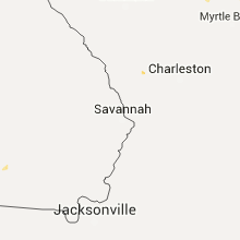
| 11:35 AM EDT | Golf Ball sized hail reported near Newport, NC, 72.8 miles ENE of Wilmington, NC, golf ball size hail and funnel cloud reported at masontown road and highway 70. |
| 12:03 PM EDT | Tree down across mill creek rd. 3/4 inch hail was also reported. time estimated from rada in carteret county NC, 77.9 miles ENE of Wilmington, NC |
| 12:15 PM EDT | Trees downed across hwy 3 in johnston county NC, 25.3 miles SE of Raleigh, NC |
| 12:15 PM EDT | Measured at mandy farms subdivsio in carteret county NC, 77 miles ENE of Wilmington, NC |
| 1:45 PM EDT | Broadcast media relayed public report of a downed trees near kenansville. time based on rada in duplin county NC, 50 miles N of Wilmington, NC |
| 2:52 PM EDT | Report of tree down across westbound lane of i-40 near exit 408 causing traffic issues. time estimated by rada in pender county NC, 14.8 miles NNE of Wilmington, NC |
| 3:51 PM EDT | Report of tree down on roadway near intersection of campbell rd and hwy 701. time estimated by rada in bladen county NC, 44.9 miles WNW of Wilmington, NC |
| 4:25 PM EDT | Large limbs down on andrew jackson hw in columbus county NC, 43.3 miles W of Wilmington, NC |
| 5:00 PM EDT | Trailor roof blown of in brunswick county NC, 10.1 miles NW of Wilmington, NC |
| 5:30 PM EDT | Storm damage reported in brunswick county NC, 15.9 miles SW of Wilmington, NC |
| 5:32 PM EDT | Numerous trees down near the hieronymus seafood resturant on market stree in new hanover county NC, 3.8 miles E of Wilmington, NC |
| 5:35 PM EDT | Major damage at the 5400 block of market stree in new hanover county NC, 2.7 miles SE of Wilmington, NC |
| 5:45 PM EDT | Quarter sized hail reported near Locust, NC, 24.9 miles ENE of Charlotte, NC, hail up to the size of quarters... was ending at the time of the call. |
| 5:50 PM EDT | Power line down on reed mine rd in cabarrus county NC, 19.1 miles E of Charlotte, NC |
Georgia
| Local Time | Report Details |
|---|---|
| 2:18 PM EDT | A tree down on home on margaret plac in fulton county GA, 4 miles WNW of Atlanta, GA |
| 5:15 PM EDT | Tree down on powerlin in decatur county GA, 37.7 miles NNW of Tallahassee, FL |
| 5:42 PM EDT | Tree down in the roa in grady county GA, 32.5 miles N of Tallahassee, FL |
| 5:44 PM EDT | Tree down on a powerline south of georgetow in quitman county GA, 57 miles SSE of Auburn, AL |
| 6:20 PM EDT | Several trees down in the city of nashvill in berrien county GA, 31.7 miles SW of Douglas, GA |
| 6:25 PM EDT | Long county reports a tree down on elim church road near cypress creek roa in long county GA, 40.9 miles WSW of Savannah, GA |
| 6:31 PM EDT | Tree blown down blocking both lanes on barrett cemetary rd at hwy 8 in long county GA, 41 miles SW of Savannah, GA |
| 6:35 PM EDT | One tree down on 40th street near the intersection with abercorn stree in chatham county GA, 2.2 miles SSW of Savannah, GA |
| 6:37 PM EDT | Chatham county emergency management reports a tree down on a power line in the 1800 block of e 41st stree in chatham county GA, 2.4 miles SSE of Savannah, GA |
| 6:37 PM EDT | Chatham county emergency management reports a tree down on a power line and a house in the 2100 block of clars avenu in chatham county GA, 3.3 miles SSE of Savannah, GA |
| 6:37 PM EDT | Chatham county emergency management reports multiple limbs and trees down at the intersection of wheaton street and waters avenue. the stop light has also been blown do in chatham county GA, 1.6 miles SSE of Savannah, GA |
| 6:45 PM EDT | Chatham county emergency management reports a tree down on powerlines in the 700 block of bradley point roa in chatham county GA, 6.3 miles SE of Savannah, GA |
| 6:45 PM EDT | Trees down in the 100 block of falligant avenu in chatham county GA, 7.6 miles ESE of Savannah, GA |
| 7:07 PM EDT | Mcintosh county reports a tree down near the intersection of hw-57 and hw-9 in mcintosh county GA, 43.2 miles SSW of Savannah, GA |
| 7:07 PM EDT | Mcintosh county reports a tree down on minton road near the intersection with shelman bluff roa in mcintosh county GA, 38.2 miles SSW of Savannah, GA |
South Carolina
| Local Time | Report Details |
|---|---|
| 3:25 PM EDT | Sc highway patrol reports 2 trees down and in the roadway on jacob white road near enoch norris road and highway 1 in beaufort county SC, 42.7 miles NNE of Savannah, GA |
| 3:40 PM EDT | Sc highway patrol reports a tree down and in the roadway on hope well road near the intersection with deer road. scdot is responding to the downed tre in hampton county SC, 52.9 miles N of Savannah, GA |
| 4:17 PM EDT | 1 tree down near the intersection of bay street and ribaut roa in beaufort county SC, 33.6 miles NE of Savannah, GA |
| 4:20 PM EDT | Sc highway patrol reports a tree down and in the roadway on gumwood drive near little capers road. scdot is responding to the downed tre in beaufort county SC, 36.6 miles NE of Savannah, GA |
| 4:27 PM EDT | Sc highway patrol reports a tree down and in the roadway on sea island parkway near polowana road. scdot is responding to the downed tre in beaufort county SC, 37.1 miles NE of Savannah, GA |
| 4:30 PM EDT | Three trees were reported down along martin luther king junior driv in beaufort county SC, 36.7 miles NE of Savannah, GA |
| 4:47 PM EDT | Sc highway patrol reports 2 trees down near the 1100 and 1200 blocks of green pond highwa in colleton county SC, 43.6 miles WSW of Charleston, SC |
| 4:58 PM EDT | Sc highway patrol reports a tree down and in the roadway on jacksonboro road near bodison memorial drive. scdot is responding to the downed tre in colleton county SC, 34.5 miles SW of Charleston, SC |
| 6:00 PM EDT | Twitter report and picture of a large tree down at the corner of king and huger street in charleston county SC, 27.6 miles S of Charleston, SC |
| 6:31 PM EDT | Kershaw county sheriff reported trees down across cheraw road near camde in kershaw county SC, 65.7 miles SSE of Charlotte, NC |
| 6:55 PM EDT | Large limbs dow in marion county SC, 74 miles NNE of Charleston, SC |
| 7:09 PM EDT | Report of tree down on us 501 near us 319. time estimated by rada in horry county SC, 72.2 miles NE of Charleston, SC |
| 8:45 PM EDT | Tree down on robinsonview rd and w old camden r in darlington county SC, 66.9 miles SE of Charlotte, NC |
Florida
| Local Time | Report Details |
|---|---|
| 3:55 PM EDT | Large tree down on powerline in killearn acre in leon county FL, 8.4 miles NE of Tallahassee, FL |
| 7:48 PM EDT | Power line down at the corner of beach blvd and san pablo rd. time estimated by rada in duval county FL, 13.2 miles ESE of Jacksonville, FL |
Nebraska
| Local Time | Report Details |
|---|---|
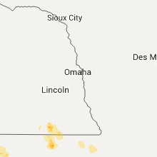
| 2:25 PM MDT | Quarter sized hail reported near Brule, NE, 56.2 miles W of North Platte, NE |
| 7:01 PM CDT | Golf Ball sized hail reported near Mc Cook, NE, 48.3 miles S of North Platte, NE, hail occurred at red willow reservoir |
| 6:01 PM MDT | Quarter sized hail reported near Imperial, NE, 54.4 miles SW of North Platte, NE, in addition to the hail... winds were estimated at 50 mph. |
| 7:51 PM CDT | Ping Pong Ball sized hail reported near Mc Cook, NE, 48.3 miles S of North Platte, NE, hail occurred at red willow reservoir. |
| 7:51 PM CDT | Golf Ball sized hail reported near Mc Cook, NE, 48.3 miles S of North Platte, NE, hail occurred at red willow reservoir. |
| 8:05 PM CDT | Golf Ball sized hail reported near Moorefield, NE, 36.2 miles SSE of North Platte, NE |
| 8:25 PM CDT | Tennis Ball sized hail reported near Mc Cook, NE, 55.4 miles S of North Platte, NE, hail up to tennis ball size. |
| 8:30 PM CDT | Baseball sized hail reported near Indianola, NE, 55.6 miles SSE of North Platte, NE, report relayed via social media. hail began at 808pm cdt as golf ball sized...worked up to the size of baseballs by 828pm cdt...and continued for several more minutes a |
| 8:33 PM CDT | Storm damage reported in frontier county NE, 42.8 miles SE of North Platte, NE |
| 8:34 PM CDT | Quarter sized hail reported near Farnam, NE, 41.3 miles SE of North Platte, NE, pea to quarter sized hail |
Colorado
| Local Time | Report Details |
|---|---|
| 3:58 PM MDT | Quarter sized hail reported near Burlington, CO, 65.3 miles SSE of Yuma, CO, mostly nickel size hail with some quarter. |
| 4:10 PM MDT | Hen Egg sized hail reported near Burlington, CO, 65.8 miles SSE of Yuma, CO, relayed via social media. large hail up to the size of hen egg. |
| 4:24 PM MDT | Golf Ball sized hail reported near Burlington, CO, 67 miles SSE of Yuma, CO, ping pong to golf ball size hail. report relayed via social media. |
Montana
| Local Time | Report Details |
|---|---|
| 4:05 PM MDT | A tree fell on the house and damaged the homes power bo in silver bow county MT, 74 miles WNW of Bozeman, MT |
| 4:05 PM MDT | A large tree fell and downed multiple power poles. the power outage affected 5000 home in silver bow county MT, 73.5 miles WNW of Bozeman, MT |
North Dakota
| Local Time | Report Details |
|---|---|
| 5:15 PM CDT | Quarter sized hail reported near Garrison, ND, 40.9 miles SSW of Minot, ND, peas and quarters. road was white. |
| 5:21 PM CDT | Social media report and vide in ward county ND, 27.3 miles SSW of Minot, ND |
| 5:55 PM CDT | Golf Ball sized hail reported near Garrison, ND, 40.6 miles S of Minot, ND |
| 6:44 PM CDT | Relayed through state radio in mclean county ND, 48.3 miles NNW of Bismarck, ND |
| 6:48 PM CDT | Storm damage reported in mclean county ND, 48.7 miles NNW of Bismarck, ND |
| 6:20 PM MDT | Very heavy rain accompanied the severe wind gust in grant county ND, 50.2 miles WSW of Bismarck, ND |
| 7:26 PM CDT | Quarter sized hail reported near Center, ND, 31.1 miles NW of Bismarck, ND, 2.5 inches of rain accompanied the hail. |
| 7:40 PM CDT | Storm damage reported in mclean county ND, 26.6 miles N of Bismarck, ND |
| 8:00 PM CDT | Storm damage reported in burleigh county ND, 30.2 miles NNE of Bismarck, ND |
| 8:05 PM CDT | Quarter sized hail reported near Bisbee, ND, 38.7 miles NW of Devils Lake, ND, few hail stones up to one inch in size. |
| 8:35 PM CDT | Quarter sized hail reported near Cando, ND, 29.7 miles NNW of Devils Lake, ND, a few hail stones up to an inch in size. |
| 8:50 PM CDT | Quarter sized hail reported near Tuttle, ND, 52.7 miles NE of Bismarck, ND, report via facebook. |
| 9:00 PM CDT | Peak wind gust measured 56 kt in pembina county ND, 74.1 miles NE of Devils Lake, ND |
| 9:56 PM CDT | Very heavy rain accompanied the strong wind in foster county ND, 47.5 miles SSW of Devils Lake, ND |
| 10:27 PM CDT | Ndawn 8 miles north of mchenry...peak measured gus in eddy county ND, 32.2 miles SSE of Devils Lake, ND |
| 10:48 PM CDT | Ndawn near peki in walsh county ND, 70.7 miles ENE of Devils Lake, ND |
| 10:48 PM CDT | Ndawn near peki in nelson county ND, 33.2 miles SE of Devils Lake, ND |
| 11:50 PM CDT | Personal davis system...peak gust in traill county ND, 42.5 miles NNW of Fargo, ND |
| 12:00 AM CDT | Two 15 to 20 ft trees down in cummings...time est from local ob showing gust of 46 mph at 1200 am in traill county ND, 46 miles NNW of Fargo, ND |
Mississippi
| Local Time | Report Details |
|---|---|
| 5:55 PM CDT | Trees were downed along sayles rd... perry rd... and murff d in grenada county MS, 56.6 miles WNW of Starkville, MS |
New Mexico
| Local Time | Report Details |
|---|---|
| 5:35 PM MDT | Trained spotter reports building damage and power lines down near the intersection of bensing and lawrence road in lea county NM, 81.5 miles NW of Odessa, TX |
| 5:50 PM MDT | Powerlines down and a mobile home blown down north of hobb in lea county NM, 77.2 miles NW of Odessa, TX |
South Dakota
| Local Time | Report Details |
|---|---|
| 5:47 PM MDT | Quarter sized hail reported near Mc Laughlin, SD, 62.3 miles S of Bismarck, ND, hail has persisted for 15 minutes. most hail pea to dime sized with a few to quarter sized. peak winds estimated at 60 mph. |
| 6:10 PM MDT | 60 to 70 mph winds. small hai in corson county SD, 64.8 miles S of Bismarck, ND |
| 7:28 PM CDT | Quarter sized hail reported near Alpena, SD, 93.2 miles S of Aberdeen, SD |
| 7:30 PM CDT | Golf Ball sized hail reported near Alpena, SD, 91.8 miles S of Aberdeen, SD |
| 6:35 PM MDT | Very strong winds and heavy rainfal in corson county SD, 70.4 miles SSE of Bismarck, ND |
| 7:35 PM CDT | Half Dollar sized hail reported near Alpena, SD, 89.1 miles S of Aberdeen, SD |
| 7:43 PM CDT | Ping Pong Ball sized hail reported near Alpena, SD, 89.7 miles S of Aberdeen, SD |
| 7:45 PM CDT | Storm damage reported in campbell county SD, 66.1 miles SSE of Bismarck, ND |
| 7:57 PM CDT | Quarter sized hail reported near Huron, SD, 77.2 miles S of Aberdeen, SD, in addition to quarter sized hail... also 45 mph wind gusts. |
| 8:00 PM CDT | Ping Pong Ball sized hail reported near Alpena, SD, 87.4 miles S of Aberdeen, SD, picture from social media |
| 8:06 PM CDT | Storm damage reported in campbell county SD, 74.6 miles SSE of Bismarck, ND |
| 8:10 PM CDT | Peak wind from the herreid rwis mesone in campbell county SD, 72.7 miles SSE of Bismarck, ND |
| 8:15 PM CDT | Quarter sized hail reported near Herreid, SD, 78 miles SSE of Bismarck, ND, quarter sized hail accompanied by 60 mph winds. |
| 8:18 PM CDT | Quarter sized hail reported near Huron, SD, 85.5 miles NW of Sioux Falls, SD |
| 8:25 PM CDT | 60 mph wind in campbell county SD, 70.4 miles W of Aberdeen, SD |
| 8:59 PM CDT | Quarter sized hail reported near Woonsocket, SD, 83.8 miles WNW of Sioux Falls, SD |
| 10:23 PM CDT | Storm damage reported in brown county SD, 26.8 miles NNW of Aberdeen, SD |
| 10:50 PM CDT | Many trees uproote in brown county SD, 24.7 miles NNE of Aberdeen, SD |
| 11:30 PM CDT | Golf Ball sized hail reported near Ramona, SD, 47.6 miles NW of Sioux Falls, SD, picture from social media |
| 11:48 PM CDT | Storm damage reported in marshall county SD, 56.7 miles ENE of Aberdeen, SD |
Missouri
| Local Time | Report Details |
|---|---|
| 6:49 PM CDT | Quarter sized hail reported near Alton, MO, 65.7 miles S of Salem, MO, report relayed to law enforcement and a report received via twitter indicate that quarter sized hail fell in alton. |
| 8:23 PM CDT | A few large trees were down and blocking the roa in oregon county MO, 76.3 miles S of Salem, MO |
Minnesota
| Local Time | Report Details |
|---|---|
| 12:30 AM CDT | Reports of shingles damaged and trees down reported on media social media site...time estimated from nearby observation site showing pk wnd 46 mph in norman county MN, 40.4 miles N of Fargo, ND |
| 12:46 AM CDT | 2 power lines down. trees dow in mahnomen county MN, 48.6 miles NE of Fargo, ND |
| 1:00 AM CDT | Tree limbs greater than 2 inches in diameter down in minerva township in clearwater county MN, 24.4 miles W of Bemidji, MN |
| 1:15 AM CDT | 10 to 15 ft pine tree dow in norman county MN, 52.9 miles NE of Fargo, ND |
Kansas
| Local Time | Report Details |
|---|---|
| 1:19 AM CDT | Storm damage reported in phillips county KS, 55.9 miles NNW of Hays, KS |
| 3:38 AM CDT | Storm damage reported in lincoln county KS, 69.5 miles E of Hays, KS |
Iowa
| Local Time | Report Details |
|---|---|
| 4:50 AM CDT | Golf Ball sized hail reported near Thompson, IA, 33.5 miles WNW of Mason City, IA, relayed via winnebago county sheriff. |
Connect with Interactive Hail Maps