

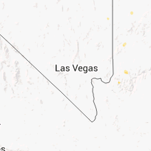
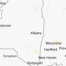
Hail Map for Tuesday, July 24, 2012

Number of Impacted Households on 7/24/2012
0
Impacted by 1" or Larger Hail
0
Impacted by 1.75" or Larger Hail
0
Impacted by 2.5" or Larger Hail
Square Miles of Populated Area Impacted on 7/24/2012
0
Impacted by 1" or Larger Hail
0
Impacted by 1.75" or Larger Hail
0
Impacted by 2.5" or Larger Hail


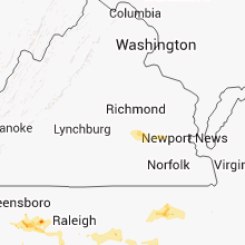


Cities Most Affected by Hail Storms of 7/24/2012
| Hail Size | Demographics of Zip Codes Affected | ||||||
|---|---|---|---|---|---|---|---|
| City | Count | Average | Largest | Pop Density | House Value | Income | Age |
| La Grange, KY | 1 | 1.75 | 1.75 | 294 | $140k | $54.9k | 38.5 |
| Scituate, MA | 1 | 1.75 | 1.75 | 1101 | $276k | $71.1k | 44.9 |
| Goshen, KY | 1 | 1.75 | 1.75 | 177 | $156k | $78.1k | 38.6 |
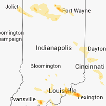
Hail and Wind Damage Spotted on 7/24/2012
Filter by Report Type:Hail ReportsWind Reports
States Impacted
Indiana, Pennsylvania, Ohio, Maryland, West Virginia, Maine, New Hampshire, Kentucky, Virginia, North Carolina, Colorado, Massachusetts, Utah, South Carolina, Tennessee, Connecticut, New Jersey, New York, South Dakota, Georgia, Florida, Wyoming, Montana, Rhode Island, North Dakota, MinnesotaIndiana
| Local Time | Report Details |
|---|---|
| 7:00 AM CDT | Estimated 70 mph gusts. multiple medium trees and branches down. basketball hoops overturne in lake county IN, 35 miles SSE of Chicago, IL |
| 7:03 AM CDT | Tree limbs down. very heavy rai in lake county IN, 27.4 miles SSE of Chicago, IL |
| 7:12 AM CDT | Large tree branches down. winds estimated at 70 mph. time estimated with rada in porter county IN, 31 miles SE of Chicago, IL |
| 7:15 AM CDT | Storm damage reported in lmz046 county IN, 38.6 miles ESE of Chicago, IL |
| 7:15 AM CDT | Storm damage reported in la porte county IN, 38.4 miles ESE of Chicago, IL |
| 7:16 AM CDT | Estimated 70 to 80 mph wind in lake county IN, 35 miles SSE of Chicago, IL |
| 7:29 AM CDT | Storm damage reported in porter county IN, 41.1 miles SE of Chicago, IL |
| 7:30 AM CDT | Large tree down on residential fence. time estimated from rada in la porte county IN, 49.2 miles SE of Chicago, IL |
| 7:30 AM CDT | Report of tree down across u.s. 421 north of u.s. 30. time estimated from rada in la porte county IN, 49.1 miles SE of Chicago, IL |
| 7:33 AM CDT | Numerous large trees dow in jasper county IN, 55.5 miles SSE of Chicago, IL |
| 7:48 AM CDT | Winds estimated up to 70 mph in knox. trees uprooted and down on cars near the county court house. time estimated from rada in starke county IN, 65.7 miles SE of Chicago, IL |
| 7:48 AM CDT | Wind gust noted by observer on awos before loss of powe in starke county IN, 62.8 miles SE of Chicago, IL |
| 7:48 AM CDT | Substantial damage to airline hangar at the knox airport with damage to several planes in starke county IN, 62.8 miles SE of Chicago, IL |
| 7:49 AM CDT | 10 to 14 inch diameter trees down on jasper county roads 1080w and state route 11 in jasper county IN, 67.3 miles SSE of Chicago, IL |
| 8:54 AM EDT | Several trees down blocking state road 143 between u.s. 421 and medaryville. time estimated from rada in pulaski county IN, 65.9 miles SE of Chicago, IL |
| 8:56 AM EDT | Report of small limbs down along u.s. 6 between bremen and nappanee. time estimated from rada in marshall county IN, 56.8 miles WNW of Fort Wayne, IN |
| 9:00 AM EDT | Report of small limbs down along u.s. 6 between bremen and nappanee. time estimated from rada in marshall county IN, 56.8 miles WNW of Fort Wayne, IN |
| 9:01 AM EDT | Storm damage reported in whitley county IN, 27.6 miles WNW of Fort Wayne, IN |
| 9:01 AM EDT | Several downed limbs about one inch in diameter. wind gust estimated around 60 mp in white county IN, 82.5 miles NNW of Indianapolis, IN |
| 9:19 AM EDT | Reports of a tree and signs down in the city of rochester. power lines and trees down across other parts of the county. time estimated from rada in fulton county IN, 58.5 miles W of Fort Wayne, IN |
| 9:19 AM EDT | Tree down blocking u.s. 35 between royal center and logansport. time estimated from rada in cass county IN, 71.2 miles WSW of Fort Wayne, IN |
| 9:38 AM EDT | Storm damage reported in miami county IN, 61.6 miles N of Indianapolis, IN |
| 9:40 AM EDT | Wind speed estimated up to 60 mp in miami county IN, 55.6 miles WSW of Fort Wayne, IN |
| 9:47 AM EDT | Unknown sized tree down on grayston avenue in huntington. time estimated from rada in huntington county IN, 23.7 miles WSW of Fort Wayne, IN |
| 9:48 AM EDT | Large branch measured one inch in diameter down on state road 9 and 100 s. time estimated from rada in huntington county IN, 29.5 miles SW of Fort Wayne, IN |
| 9:55 AM EDT | Power knocked out by storm winds at tri-central high schoo in tipton county IN, 42.4 miles N of Indianapolis, IN |
| 9:55 AM EDT | Two foot diameter limb downed by thunderstorm wind in town of sycamor in howard county IN, 51.8 miles NNE of Indianapolis, IN |
| 10:00 AM EDT | Two tree limbs down...approximately 1 inch in diamete in howard county IN, 49.2 miles N of Indianapolis, IN |
| 10:25 AM EDT | Wind gust measured at memorial drive and biltmore street. tree limbs also downed nearby at sutton elementary schoo in delaware county IN, 50.2 miles NE of Indianapolis, IN |
| 10:30 AM EDT | Roof damage at muncie mall on east side. water damage occurrin in delaware county IN, 50.2 miles NE of Indianapolis, IN |
| 10:40 AM EDT | Roof damage to ama aeronautical museum at 12th and sr6 in delaware county IN, 50.2 miles NE of Indianapolis, IN |
| 10:58 AM EDT | Trees down in wayne county IN, 58.2 miles ENE of Indianapolis, IN |
| 11:03 AM EDT | Tree down on sr 227 at weiss road in wayne county IN, 55.5 miles NNW of Cincinnati, OH |
| 11:10 AM EDT | Numerous trees down between and including economy and richmond...including a large tree down on a house in richmon in wayne county IN, 54 miles NNW of Cincinnati, OH |
| 4:38 PM CDT | Two large trees downed across highway 15 in perry county IN, 44 miles E of Evansville, IN |
| 4:38 PM CDT | Two large trees downed across highway 84 in perry county IN, 44 miles E of Evansville, IN |
| 4:45 PM CDT | A few tree limbs and one tree down on state route 545. hail also rep in spencer county IN, 41.3 miles E of Evansville, IN |
| 8:01 PM EDT | Quarter sized hail reported near Sellersburg, IN, 27.8 miles N of Louisville, KY |
Pennsylvania
| Local Time | Report Details |
|---|---|
| 8:00 AM EDT | Half Dollar sized hail reported near Imperial, PA, 12.8 miles W of Pittsburgh, PA |
| 8:12 AM EDT | Half Dollar sized hail reported near Pittsburgh, PA, 0.9 miles E of Pittsburgh, PA |
| 8:14 AM EDT | Half Dollar sized hail reported near Imperial, PA, 15 miles W of Pittsburgh, PA, event occurred between 759 am 07/24/2012 and 814 am 07/24/2012 |
| 8:27 AM EDT | Half Dollar sized hail reported near Pittsburgh, PA, 9.5 miles E of Pittsburgh, PA, event occurred between 812 am 07/24/2012 and 827 am 07/24/2012 |
| 8:54 AM EDT | Trees reported dow in westmoreland county PA, 17.7 miles ESE of Pittsburgh, PA |
| 9:25 AM EDT | Trees down across roads and utility pole split in hal in somerset county PA, 56.1 miles ESE of Pittsburgh, PA |
| 10:58 AM EDT | Trees reported down near confluenc in somerset county PA, 55.3 miles SE of Pittsburgh, PA |
Ohio
| Local Time | Report Details |
|---|---|
| 8:21 AM EDT | Large tree limb dow in miami county OH, 65.9 miles W of Columbus, OH |
| 10:45 AM EDT | Tree dwon on state route 49 south of state route 4 in darke county OH, 64.4 miles SSE of Fort Wayne, IN |
| 10:47 AM EDT | Trees dow in darke county OH, 64.4 miles SSE of Fort Wayne, IN |
| 10:52 AM EDT | Tree down along route 36 east of greenville in darke county OH, 68.8 miles N of Cincinnati, OH |
| 10:53 AM EDT | Trees dow in darke county OH, 68.8 miles N of Cincinnati, OH |
| 11:10 AM EDT | One tree dow in clark county OH, 44.6 miles W of Columbus, OH |
| 11:12 AM EDT | Several trees down in preble county OH, 44.9 miles N of Cincinnati, OH |
| 11:33 AM EDT | Large branches broken off in butler county OH, 28.7 miles NNE of Cincinnati, OH |
| 11:40 AM EDT | Large tree down blocking roadwa in greene county OH, 48.5 miles WSW of Columbus, OH |
| 11:43 AM EDT | A large tree was downed along us highway 22. time estimated from rada in clinton county OH, 36.3 miles NE of Cincinnati, OH |
| 11:45 AM EDT | Scattered trees down across eastern butler county in butler county OH, 19.8 miles N of Cincinnati, OH |
| 11:48 AM EDT | One tree blown down in clinton county OH, 35.7 miles ENE of Cincinnati, OH |
| 11:48 AM EDT | Traffic light signals blown off their wires near i-75 and liberty way exchang in butler county OH, 19.6 miles NNE of Cincinnati, OH |
| 11:50 AM EDT | Storm damage reported in warren county OH, 20.4 miles NNE of Cincinnati, OH |
| 11:50 AM EDT | Two trees down...one fell on a house in hamilton county OH, 11.9 miles NE of Cincinnati, OH |
| 11:50 AM EDT | Large branches broken in butler county OH, 15.5 miles N of Cincinnati, OH |
| 11:52 AM EDT | Scattered trees down in mason and deerfield township area in warren county OH, 20.4 miles NNE of Cincinnati, OH |
| 12:07 PM EDT | Scattered trees down in northern clermont county in clermont county OH, 22.8 miles ENE of Cincinnati, OH |
| 12:07 PM EDT | Scattered trees down in northern clermont county in clermont county OH, 24.6 miles ENE of Cincinnati, OH |
| 12:11 PM EDT | 1 large tree dow in highland county OH, 48.6 miles E of Cincinnati, OH |
| 12:16 PM EDT | A few trees down in southwest clermont county...including nordike at 9-mile road in clermont county OH, 11.7 miles ESE of Cincinnati, OH |
| 12:25 PM EDT | Large tree dow in brown county OH, 31.4 miles E of Cincinnati, OH |
| 12:27 PM EDT | Trees and power lines down near oh-133 and clark stree in clermont county OH, 25 miles ESE of Cincinnati, OH |
| 12:30 PM EDT | A few trees down in southern clermont county...including oh-133 at oh-774 in clermont county OH, 27.2 miles SE of Cincinnati, OH |
| 12:30 PM EDT | Trees down along eden roa in brown county OH, 33.2 miles ESE of Cincinnati, OH |
| 12:30 PM EDT | One tree blown down. also reported by dept. of highways in adams county OH, 55.3 miles SE of Cincinnati, OH |
| 12:40 PM EDT | One tree was blow down. also reported by the highway dep in adams county OH, 54.3 miles ESE of Cincinnati, OH |
Maryland
| Local Time | Report Details |
|---|---|
| 11:43 AM EDT | Trees reported dow in garrett county MD, 57.4 miles NE of Elkins, WV |
| 11:50 AM EDT | Quarter sized hail reported near Accident, MD, 56.2 miles NNE of Elkins, WV |
| 4:23 PM EDT | Wires down on frederick rd in frederick county MD, 48.9 miles WNW of Baltimore, MD |
| 4:25 PM EDT | Large oak tree split a few feet up from base as a result of strong thunderstorm wind in frederick county MD, 51.4 miles WNW of Baltimore, MD |
| 5:23 PM EDT | Tree down at phoenix rd and carroll r in baltimore county MD, 15.8 miles N of Baltimore, MD |
| 5:30 PM EDT | Branches dow in montgomery county MD, 35.2 miles W of Baltimore, MD |
| 5:34 PM EDT | Tree down along westbound route 43 near baltimore beltwa in baltimore county MD, 7.8 miles NE of Baltimore, MD |
West Virginia
| Local Time | Report Details |
|---|---|
| 11:58 AM EDT | Tree down across portion of rt 4 in mineral county WV, 55.2 miles NE of Elkins, WV |
| 12:15 PM EDT | Tree down near instersection of patterson creek rd and headsville r in mineral county WV, 61.9 miles ENE of Elkins, WV |
| 12:52 PM EDT | Trees down near seymourville in grant county WV, 40.6 miles ENE of Elkins, WV |
| 12:53 PM EDT | Several trees down in the moorefield are in hardy county WV, 48 miles ENE of Elkins, WV |
| 1:16 PM EDT | Multiple trees down along mill gap-thorne bottom rd one half mile east of rt 23 in hardy county WV, 56.3 miles E of Elkins, WV |
| 1:18 PM EDT | Tree tops twisted and ripped off and landed in driveways along back road drive off rte. 259 in the lower cove road are in hardy county WV, 54.1 miles E of Elkins, WV |
| 1:20 PM EDT | Small branches broken. heavy rain and cloud to ground lightnin in cabell county WV, 43.1 miles W of Charleston, WV |
| 1:30 PM EDT | Several trees down in the moorfield area. tree tops twisted and ripped off... landed in driveways along back road drive off of rte. 259 in the lower cove road area park in hardy county WV, 48 miles ENE of Elkins, WV |
| 2:30 PM EDT | Trees down near beards fork on wv state rt 6 in fayette county WV, 29.9 miles SE of Charleston, WV |
| 2:42 PM EDT | Trees down on wv rt 612 near scarbro. timed from radar in fayette county WV, 37.1 miles SE of Charleston, WV |
| 2:55 PM EDT | Tree down on wv rt 60 near ponderos in fayette county WV, 49.2 miles ESE of Charleston, WV |
Maine
| Local Time | Report Details |
|---|---|
| 12:30 PM EDT | York county ema reports trees down in limington and limeric in york county ME, 23.2 miles WNW of Portland, ME |
| 12:46 PM EDT | Porland public works... tree down at the corner of hobard and congress in cumberland county ME, 0.2 miles WNW of Portland, ME |
| 12:48 PM EDT | 1-2 diameter branches down and blown awa in cumberland county ME, 0.2 miles WNW of Portland, ME |
| 12:55 PM EDT | Nws employee estimates 50-60mph winds on commercial street in downtown portlan in cumberland county ME, 0.2 miles WNW of Portland, ME |
| 12:55 PM EDT | Top of flagpole blown off in cumberland county ME, 7.4 miles SSE of Portland, ME |
| 1:05 PM EDT | Quarter sized hail reported near Cape Elizabeth, ME, 7.4 miles SSE of Portland, ME |
| 1:18 PM EDT | Quarter sized hail reported near Alna, ME, 45.2 miles NE of Portland, ME |
New Hampshire
| Local Time | Report Details |
|---|---|
| 12:40 PM EDT | Local police reported trees and wires down on crown point road in strafford county NH, 51.7 miles WSW of Portland, ME |
Kentucky
| Local Time | Report Details |
|---|---|
| 12:55 PM EDT | Several trees and large branches snapped. time estimate in mason county KY, 49.8 miles SE of Cincinnati, OH |
| 1:00 PM EDT | One tree blown dow in mason county KY, 57 miles SE of Cincinnati, OH |
| 1:00 PM EDT | Several trees blown dow in mason county KY, 58.3 miles SE of Cincinnati, OH |
| 1:30 PM EDT | Numerous trees down in hillsbor in fleming county KY, 44.2 miles NNE of Irvine, KY |
| 1:30 PM EDT | One tree down on highway 333 in magoffin county KY, 47.4 miles E of Irvine, KY |
| 1:40 PM EDT | Tree down on highway 88 in elliott county KY, 59.3 miles ENE of Irvine, KY |
| 1:50 PM EDT | One tree down on 1944 near white oak churc in bath county KY, 34.8 miles NNE of Irvine, KY |
| 1:50 PM EDT | One tree down on 1944 near white oa in bath county KY, 34.8 miles NNE of Irvine, KY |
| 1:55 PM EDT | One tree down on vanlandingham roa in bath county KY, 37.8 miles NNE of Irvine, KY |
| 1:55 PM EDT | Trees down on highway 71 in morgan county KY, 44.4 miles ENE of Irvine, KY |
| 2:17 PM EDT | One tree down on highway 772...one mile down from highway 46 in morgan county KY, 33.6 miles ENE of Irvine, KY |
| 2:20 PM EDT | Trees down on highway 77 in morgan county KY, 32.1 miles ENE of Irvine, KY |
| 2:20 PM EDT | 1 tree down on bryant fork roa in morgan county KY, 32.8 miles ENE of Irvine, KY |
| 3:25 PM EDT | 4 inch diameter tree down on route 80 in letcher county KY, 48.8 miles NW of Bristol, TN |
| 5:30 PM EDT | Several trees reported down along levelwoods road. delayed repor in larue county KY, 35.8 miles SSE of Louisville, KY |
| 5:42 PM EDT | Trees down in taylor county KY, 38.6 miles SSE of Louisville, KY |
| 5:20 PM CDT | One tree down on hwy 569 at gumm spring roa in green county KY, 41.6 miles S of Louisville, KY |
| 6:51 PM EDT | Several trees reported down along siberia road. delayed repor in larue county KY, 31.6 miles SSW of Louisville, KY |
| 8:10 PM EDT | Tree down on chamberlain lane in jefferson county KY, 24.3 miles NNE of Louisville, KY |
| 8:20 PM EDT | Golf Ball sized hail reported near Goshen, KY, 29.9 miles NNE of Louisville, KY |
| 8:27 PM EDT | Quarter sized hail reported near Goshen, KY, 29.9 miles NNE of Louisville, KY |
| 8:52 PM EDT | Golf Ball sized hail reported near La Grange, KY, 33.8 miles NNE of Louisville, KY |
| 9:13 PM EDT | Ping Pong Ball sized hail reported near Pleasureville, KY, 39.8 miles NE of Louisville, KY |
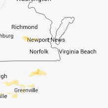
Virginia
| Local Time | Report Details |
|---|---|
| 1:18 PM EDT | 1 tree 8-12 inches across across down in the town of bergto in rockingham county VA, 49.4 miles ESE of Elkins, WV |
| 2:27 PM EDT | 2 trees down onto vehicles on mountain valley roa in rockingham county VA, 67.1 miles ESE of Elkins, WV |
| 2:42 PM EDT | Several trees down in elkto in rockingham county VA, 75.1 miles ESE of Elkins, WV |
| 3:45 PM EDT | Tree down on powerlines in chesterfield county VA, 22.6 miles SE of Richmond, VA |
| 3:50 PM EDT | Large tree down in city of hopewell county VA, 24.3 miles SE of Richmond, VA |
| 3:50 PM EDT | Several trees down...one on a house...city point sectio in city of hopewell county VA, 24.3 miles SE of Richmond, VA |
| 3:56 PM EDT | Several trees down in big stone ga in wise county VA, 36.1 miles WNW of Bristol, TN |
| 4:00 PM EDT | Tree down on powerlines in chesterfield county VA, 22.6 miles SE of Richmond, VA |
| 4:20 PM EDT | One tree down across railroad tracks in city of bristol in city of bristol county VA, 3.1 miles ENE of Bristol, TN |
| 4:46 PM EDT | Trees and several medium-sized limbs down on packets ct in james city county VA, 47.1 miles NW of Virginia Beach, VA |
| 5:09 PM EDT | Holiday park area in city of hampton county VA, 24.3 miles NNW of Virginia Beach, VA |
| 5:14 PM EDT | Storm damage reported in city of hampton county VA, 27.6 miles NW of Virginia Beach, VA |
| 5:15 PM EDT | Storm damage reported in city of poquoson county VA, 28.4 miles NNW of Virginia Beach, VA |
| 5:15 PM EDT | Tree down across road in city of newport ne county VA, 42.2 miles NW of Virginia Beach, VA |
| 5:15 PM EDT | Tree down on telephone wires in city of newport ne county VA, 29.6 miles NW of Virginia Beach, VA |
| 5:15 PM EDT | Trees down on road in city of newport ne county VA, 33.3 miles NW of Virginia Beach, VA |
| 5:16 PM EDT | Storm damage reported in city of hampton county VA, 27.6 miles NW of Virginia Beach, VA |
| 5:19 PM EDT | Storm damage reported in city of newport ne county VA, 25.8 miles NNW of Virginia Beach, VA |
| 5:22 PM EDT | Storm damage reported in anz632 county VA, 23.2 miles NNW of Virginia Beach, VA |
| 5:26 PM EDT | Tree limbs six ft long blocking road in city of hampton county VA, 26.2 miles NW of Virginia Beach, VA |
| 5:35 PM EDT | Storm damage reported in anz632 county VA, 19.7 miles N of Virginia Beach, VA |
| 1:57 AM EDT | Two large trees down at the intersection of freestone valley road and veterans roa in tazewell county VA, 39.7 miles NE of Bristol, TN |
| 2:06 AM EDT | One tree down on hollow roa in smyth county VA, 43.6 miles ENE of Bristol, TN |
| 2:30 AM EDT | Tree down on a trailer home...reported by dispatc in washington county VA, 16.2 miles ENE of Bristol, TN |
| 2:50 AM EDT | A few trees dow in city of bristol county VA, 3.1 miles ENE of Bristol, TN |
North Carolina
| Local Time | Report Details |
|---|---|
| 1:45 PM EDT | Several trees and powerlines dow in ashe county NC, 35.3 miles ESE of Bristol, TN |
| 2:41 PM EDT | Multiple trees down and multiple power outages in and around the troy area in montgomery county NC, 48.3 miles E of Charlotte, NC |
| 2:42 PM EDT | Large tree blocking sandy creek drive in randolph county NC, 56.3 miles W of Raleigh, NC |
| 2:45 PM EDT | Multiple trees down in alamance county NC, 47.7 miles W of Raleigh, NC |
| 2:50 PM EDT | Tree down on pwerline in liberty. time estimated by rada in randolph county NC, 52.3 miles W of Raleigh, NC |
| 2:50 PM EDT | Several trees down in southwestern alamance count in alamance county NC, 46.8 miles W of Raleigh, NC |
| 2:53 PM EDT | Tree blocking old liberty rd in randolph county NC, 58.4 miles W of Raleigh, NC |
| 2:54 PM EDT | Multiple trees down in the vicinity of ramseur julian rd and sandy creek church r in randolph county NC, 56.1 miles W of Raleigh, NC |
| 2:55 PM EDT | Trees and power lines down on jess hackett rd in randolph county NC, 59.5 miles W of Raleigh, NC |
| 2:57 PM EDT | One tree down on siler city snow camp road in chatham county NC, 44.2 miles W of Raleigh, NC |
| 2:58 PM EDT | Multiple trees and power lines down in alamance county NC, 42.6 miles W of Raleigh, NC |
| 2:58 PM EDT | Tree down across ramseur julian road in randolph county NC, 56 miles W of Raleigh, NC |
| 3:03 PM EDT | One tree down on mount vernon hickory mountain road in chatham county NC, 39.8 miles W of Raleigh, NC |
| 3:04 PM EDT | Tree down across church street in randolph county NC, 56.7 miles W of Raleigh, NC |
| 3:04 PM EDT | Tree down across nc hwy 49n in randolph county NC, 55.5 miles W of Raleigh, NC |
| 3:10 PM EDT | Large tree down on powerlines in orange county NC, 32.3 miles WNW of Raleigh, NC |
| 3:14 PM EDT | One tree on a fence at on gilmore road in chatham county NC, 27.7 miles W of Raleigh, NC |
| 3:16 PM EDT | Tree blocking both lanes on fork creek mill road in randolph county NC, 61.3 miles WSW of Raleigh, NC |
| 3:20 PM EDT | Tree blocking northbound lane of us hwy 421 in randolph county NC, 55.7 miles W of Raleigh, NC |
| 3:25 PM EDT | Trees and powerlines down in carrboro in orange county NC, 26.2 miles WNW of Raleigh, NC |
| 3:26 PM EDT | Multiple trees down and power lines down in chapel hill in orange county NC, 24.9 miles WNW of Raleigh, NC |
| 3:29 PM EDT | Storm damage reported in chatham county NC, 21.6 miles WNW of Raleigh, NC |
| 3:30 PM EDT | On tree down on glendon road in moore county NC, 48 miles WSW of Raleigh, NC |
| 3:30 PM EDT | On tree down on street place road in glendon in moore county NC, 48 miles WSW of Raleigh, NC |
| 3:31 PM EDT | Tree down on troy smith rd in randolph county NC, 54.9 miles W of Raleigh, NC |
| 3:34 PM EDT | Tree down on norh smith st and vance ave in randolph county NC, 52.9 miles W of Raleigh, NC |
| 3:36 PM EDT | One tree down on jones family roa in wake county NC, 12 miles SW of Raleigh, NC |
| 3:40 PM EDT | Numerous trees were reported down throughout the count in moore county NC, 56 miles SW of Raleigh, NC |
| 3:40 PM EDT | Two trees down at 2552 river roa in harnett county NC, 25.7 miles SW of Raleigh, NC |
| 3:41 PM EDT | One tree down on ridge roa in wake county NC, 3.2 miles NW of Raleigh, NC |
| 3:42 PM EDT | Two trees were reported down across us hwy 220 near sandy ridge church roa in richmond county NC, 61.8 miles ESE of Charlotte, NC |
| 3:44 PM EDT | One tree down on white oak roa in wake county NC, 1.7 miles N of Raleigh, NC |
| 3:44 PM EDT | Roof damage to tiki bar near sanford in lee county NC, 36.3 miles SW of Raleigh, NC |
| 3:44 PM EDT | One tree down on transylvania av in wake county NC, 3.2 miles NNW of Raleigh, NC |
| 3:45 PM EDT | Tree down on leesville road in raleigh in wake county NC, 10.5 miles NW of Raleigh, NC |
| 3:49 PM EDT | Multiple trees down along 70 near 401 and tryon road in wake county NC, 3.8 miles S of Raleigh, NC |
| 3:49 PM EDT | Three trees down at smithfield road and grasshopper roa in johnston county NC, 13.3 miles ESE of Raleigh, NC |
| 3:51 PM EDT | Multiple trees dow in wake county NC, 8.1 miles SE of Raleigh, NC |
| 3:55 PM EDT | Tree down on 440 beltline near glenwood in wake county NC, 4.1 miles NNW of Raleigh, NC |
| 3:55 PM EDT | Tree down on a truck in wake county NC, 3.8 miles W of Raleigh, NC |
| 4:00 PM EDT | Tree on residence - 164 graham st in randolph county NC, 51 miles W of Raleigh, NC |
| 4:00 PM EDT | Tree down on jim christian roa in harnett county NC, 28.3 miles SSW of Raleigh, NC |
| 4:03 PM EDT | 2 large trees down with one of them on a house in richmond county NC, 69.7 miles ESE of Charlotte, NC |
| 4:07 PM EDT | Tree blocking both lanes at 6666 frazier marsh rd in randolph county NC, 70 miles W of Raleigh, NC |
| 4:10 PM EDT | One tree down at the intersection of wellstone and hoover roa in harnett county NC, 39 miles SW of Raleigh, NC |
| 4:11 PM EDT | Tree blocking both lanes on flynt rd in randolph county NC, 51 miles W of Raleigh, NC |
| 4:17 PM EDT | Numerous trees down across the northern half of the county in cumberland county NC, 51.4 miles SSW of Raleigh, NC |
| 4:26 PM EDT | Tree down and power out at gruber and longstreet on fort bragg in cumberland county NC, 49.6 miles SSW of Raleigh, NC |
| 4:30 PM EDT | Tree down on scull road in hoke county NC, 59.7 miles SSW of Raleigh, NC |
| 4:38 PM EDT | One tree down in edgecombe county NC, 54.7 miles E of Raleigh, NC |
| 4:42 PM EDT | Tree dow in johnston county NC, 34 miles SSE of Raleigh, NC |
| 4:44 PM EDT | 911 center reports numerous trees down across the county in sampson county NC, 58.1 miles S of Raleigh, NC |
| 4:44 PM EDT | Trees were reported down at the intersection of sandhill road and osborne roa in richmond county NC, 62.3 miles ESE of Charlotte, NC |
| 4:44 PM EDT | Tree down on a power line in edgecombe county NC, 51.1 miles E of Raleigh, NC |
| 4:48 PM EDT | Tree down on storage building in johnston county NC, 31.9 miles SSE of Raleigh, NC |
| 4:53 PM EDT | Spotter estimated 60 -70 mph wind in pitt county NC, 59.9 miles ESE of Raleigh, NC |
| 4:53 PM EDT | Two trees down of 12 to 14 inch diamete in pitt county NC, 59.9 miles ESE of Raleigh, NC |
| 4:54 PM EDT | Multiple trees down along highway 42 near conetoe in edgecombe county NC, 68.7 miles E of Raleigh, NC |
| 4:58 PM EDT | 54 kt wind gust at kgs in wayne county NC, 48.8 miles SE of Raleigh, NC |
| 4:58 PM EDT | Multiple trees down around seven springs in wayne county NC, 58.9 miles SE of Raleigh, NC |
| 5:02 PM EDT | Trees down in warsaw. time estimated by rada in duplin county NC, 53.4 miles N of Wilmington, NC |
| 5:05 PM EDT | Trees and powerlines down. time estimated by rada in duplin county NC, 50 miles N of Wilmington, NC |
| 5:15 PM EDT | Pine trees dow in pitt county NC, 60.7 miles ESE of Raleigh, NC |
| 5:25 PM EDT | Several trees down in kinsto in lenoir county NC, 68.8 miles ESE of Raleigh, NC |
| 5:25 PM EDT | Tree down in la grang in lenoir county NC, 58.2 miles SE of Raleigh, NC |
| 5:28 PM EDT | Power lines down just north of kinston city limit in lenoir county NC, 68.5 miles ESE of Raleigh, NC |
| 5:29 PM EDT | Power lines down in washingto in beaufort county NC, 90.9 miles E of Raleigh, NC |
| 5:30 PM EDT | Tree down on voice of america roa in pitt county NC, 83.9 miles ESE of Raleigh, NC |
| 5:35 PM EDT | Reports of trees down and a light pole snapped on woodard rd in bertie county NC, 73 miles SW of Virginia Beach, VA |
| 5:40 PM EDT | Tree down on hwy 17 s near old for in beaufort county NC, 89 miles E of Raleigh, NC |
| 5:40 PM EDT | Trees and powerline down on hwy 17 in martin county NC, 82 miles SW of Virginia Beach, VA |
| 5:40 PM EDT | Four trees down across hwy 90 in martin county NC, 78.6 miles E of Raleigh, NC |
| 5:42 PM EDT | Trees snapped and blown down on hwy 7 in craven county NC, 73.3 miles NNE of Wilmington, NC |
| 5:42 PM EDT | Large tree snapped approx 1 foot in diameter on hwy 7 in craven county NC, 72.5 miles NNE of Wilmington, NC |
| 5:42 PM EDT | Trees snapped and blown down on hwy 7 in craven county NC, 72.8 miles NNE of Wilmington, NC |
| 5:50 PM EDT | Estimated 50 to 60 mph winds on hwy 7 in craven county NC, 72.4 miles NNE of Wilmington, NC |
| 5:50 PM EDT | Large tree limbs down in jacksonvill in onslow county NC, 47.8 miles NE of Wilmington, NC |
| 5:57 PM EDT | Tree down on the intersection of aurora rd and guinea mill r in craven county NC, 88.6 miles NE of Wilmington, NC |
| 6:00 PM EDT | Reports of trees and powerlines down in edenton in chowhan county NC, 55.1 miles SSW of Virginia Beach, VA |
| 6:01 PM EDT | Tree down on powerlines in bridgeton near hwy 70. time estimated by rada in craven county NC, 80.6 miles NE of Wilmington, NC |
| 6:30 PM EDT | Alligator river bridge tender measured a 60 mph wind gust in amz130 county NC, 59.7 miles S of Virginia Beach, VA |
| 6:43 PM EDT | Tree down on power line. time estimated by rada in dare county NC, 50.9 miles SSE of Virginia Beach, VA |
| 2:45 AM EDT | Tree fell across east little creek roa in ashe county NC, 39.4 miles E of Bristol, TN |
| 3:20 AM EDT | Few trees and powerlines dow in ashe county NC, 49.7 miles ESE of Bristol, TN |
Colorado
| Local Time | Report Details |
|---|---|
| 1:00 PM MDT | Wind gust measured at the eagle snote in san juan county CO, 83.5 miles NNE of Farmington, NM |
Massachusetts
| Local Time | Report Details |
|---|---|
| 3:16 PM EDT | Tree across road west brookfield st.... tree on wires on prouty r in worcester county MA, 50.4 miles NW of Providence, RI |
| 3:20 PM EDT | Half Dollar sized hail reported near Salem, MA, 56.1 miles NNE of Providence, RI |
| 3:22 PM EDT | Tree down on route 32 in hampshire county MA, 52.2 miles NW of Providence, RI |
| 3:26 PM EDT | Tree blocking church st.... tree down on woods s in worcester county MA, 47.6 miles NW of Providence, RI |
| 5:01 PM EDT | Large limb down in plymouth county MA, 26.3 miles E of Providence, RI |
| 9:24 PM EDT | Golf Ball sized hail reported near Scituate, MA, 43.3 miles NE of Providence, RI, ham radio |
Utah
| Local Time | Report Details |
|---|---|
| 1:30 PM MDT | Storm damage reported in washington county UT, 7 miles SSW of Saint George, UT |
South Carolina
| Local Time | Report Details |
|---|---|
| 3:44 PM EDT | The allendale emergency manager reported several large trees and power lines down near the intersection of highway 125 and millett road. one tree fell on a tanke in allendale county SC, 35 miles SE of Augusta, GA |
| 6:07 PM EDT | One very large branch down at a residence and several other limbs of various sizes down in the immediate area. power was ou in laurens county SC, 31.8 miles ESE of Greenville, SC |
| 6:14 PM EDT | Public and utility company reported trees and powerlines down on wagon in lancaster county SC, 44 miles SSE of Charlotte, NC |
| 6:15 PM EDT | Tree down at the intersection of georgia road and baynes creek roa in laurens county SC, 32.6 miles SE of Greenville, SC |
| 6:18 PM EDT | Highway patrol reported trees down near white oak in fairfield county SC, 54.3 miles SSW of Charlotte, NC |
| 6:22 PM EDT | Report of large limbs down and power outages in winnsbor in fairfield county SC, 59.8 miles SSW of Charlotte, NC |
| 6:25 PM EDT | Trees down around hickory taver in laurens county SC, 31.7 miles SE of Greenville, SC |
| 6:26 PM EDT | Powerlines down near converse college on blue ridge street and high tension powerline reported down in the hillbrook are in spartanburg county SC, 41.9 miles ENE of Greenville, SC |
| 6:28 PM EDT | Two trees down. one tree blocking roadway with powerlines down on woodland street just off pine street. the other was half of a maple tree split on anita driv in spartanburg county SC, 40.4 miles E of Greenville, SC |
| 6:30 PM EDT | Tree in roadway at southport road and cedar springs roa in spartanburg county SC, 40.8 miles E of Greenville, SC |
| 6:55 PM EDT | Trees reported to be down around enore in spartanburg county SC, 37.8 miles ESE of Greenville, SC |
| 6:56 PM EDT | Tree in roadway near intersection of highway 252 and shirley store roa in anderson county SC, 24.2 miles S of Greenville, SC |
| 6:58 PM EDT | Large branches dow in greenwood county SC, 36.7 miles SE of Greenville, SC |
| 7:00 PM EDT | Tree in roadway near intersection of highway 185 and highway 2 in anderson county SC, 27.6 miles S of Greenville, SC |
| 7:17 PM EDT | Two trees down in star in anderson county SC, 31.6 miles S of Greenville, SC |
| 7:18 PM EDT | Tree in roadway near intersection of highway 72 and renno roa in laurens county SC, 52.3 miles ESE of Greenville, SC |
| 7:28 PM EDT | Tree in roadway near intersection of delta road and whitmire highwa in union county SC, 59.4 miles ESE of Greenville, SC |
| 8:57 PM EDT | The berkeley 911 call center relayed a report of a tree down along arrowhead roa in berkeley county SC, 15.7 miles NNE of Charleston, SC |
| 9:55 PM EDT | The public reported 1 tree down along interstate 26 between mile markers 201 and 20 in berkeley county SC, 13.7 miles SSW of Charleston, SC |
| 9:59 PM EDT | Powerlines down along highway 176 near the mcalister smith funeral home. time estimated based on rada in berkeley county SC, 13.3 miles SSW of Charleston, SC |
| 10:25 PM EDT | Tree down along highway 601 near crocketville. time estimated based on rada in hampton county SC, 57.8 miles N of Savannah, GA |
| 10:37 PM EDT | Tree down near the intersection of locust street and shaw drive. time estimated based on rada in hampton county SC, 54.4 miles N of Savannah, GA |
| 10:40 PM EDT | A tree was reported down near the intersection of clinic drive and ace basin parkwa in colleton county SC, 39.2 miles SW of Charleston, SC |
| 10:40 PM EDT | Sc highway patrol reports a tree down and in the roadway near the intersection of pocotaligo road and tulifinney roa in hampton county SC, 43.1 miles NNE of Savannah, GA |
| 11:15 PM EDT | 1 palmetto tree down. very strong wind lasted 2 to 3 minute in beaufort county SC, 34.4 miles NE of Savannah, GA |
Tennessee
| Local Time | Report Details |
|---|---|
| 4:14 PM EDT | One tree down blocking road in bristol t in sullivan county TN, 1.9 miles SE of Bristol, TN |
| 4:35 PM EDT | One tree down in kingspor in sullivan county TN, 19.3 miles WSW of Bristol, TN |
| 4:41 PM EDT | Several trees down in elizabethton in carter county TN, 17.4 miles S of Bristol, TN |
| 5:12 PM EDT | One tree down in johnson cit in washington county TN, 19.9 miles SSW of Bristol, TN |
| 5:12 PM EDT | Quarter sized hail reported near Johnson City, TN, 19.9 miles SSW of Bristol, TN |
Connecticut
| Local Time | Report Details |
|---|---|
| 4:18 PM EDT | Tree down on wires on colburn r in tolland county CT, 46 miles WNW of Providence, RI |
| 5:00 PM EDT | Trees and wires down in litchfield county CT, 67.2 miles NNE of Brooklyn, NY |
| 5:00 PM EDT | Quarter sized hail reported near Sherman, CT, 66.4 miles NNE of Brooklyn, NY, dime to quarter size hail. |
| 5:15 PM EDT | Multiple trees and large branches down closing beach street off of spring street and pool road near maple avenue and laydon driv in new haven county CT, 75.8 miles NE of Brooklyn, NY |
| 5:30 PM EDT | Large tree snapped halfway up trunk on pine rock ave at st anns park in new haven county CT, 73.7 miles NE of Brooklyn, NY |
| 5:45 PM EDT | Multiple large branches down in fairfield county CT, 63.6 miles NE of Brooklyn, NY |
New Jersey
| Local Time | Report Details |
|---|---|
| 4:25 PM EDT | Trees and power lines down in cape may county NJ, 53.3 miles NNE of Ocean City, MD |
| 5:25 PM EDT | Power lines down due to wind in salem county NJ, 63.3 miles ENE of Baltimore, MD |
| 5:35 PM EDT | Power lines down due to wind in salem county NJ, 63.9 miles ENE of Baltimore, MD |
New York
| Local Time | Report Details |
|---|---|
| 4:30 PM EDT | Trees down rte 82 nr rte 44 in dutchess county NY, 69.6 miles S of Schenectady, NY |
| 4:35 PM EDT | Trees down rte 82 nr rte 44 in dutchess county NY, 69.6 miles S of Schenectady, NY |
| 6:20 PM EDT | Large branches down at intersection of reeve and new suffolk ave in suffolk county NY, 78.4 miles ENE of Brooklyn, NY |
South Dakota
| Local Time | Report Details |
|---|---|
| 2:32 PM MDT | Quarter sized hail reported near Blackhawk, SD, 6.5 miles NW of Rapid City, SD |
| 2:37 PM MDT | Quarter sized hail reported near Blackhawk, SD, 8.1 miles NNW of Rapid City, SD, hail lasted 5 minutes /237 pm to 243 pm/ |
| 5:00 PM MDT | Storm damage reported in butte county SD, 53.4 miles NW of Rapid City, SD |
| 5:05 PM MDT | Quarter sized hail reported near Sturgis, SD, 17.8 miles NW of Rapid City, SD |
| 8:10 PM MDT | Storm damage reported in haakon county SD, 59.3 miles WSW of Pierre, SD |
| 8:45 PM MDT | Storm damage reported in custer county SD, 46.2 miles WSW of Rapid City, SD |
| 9:30 PM MDT | Storm damage reported in pennington county SD, 38.1 miles ESE of Rapid City, SD |
| 10:15 PM MDT | Storm damage reported in pennington county SD, 36.4 miles E of Rapid City, SD |
| 10:20 PM MDT | Storm damage reported in pennington county SD, 36.9 miles E of Rapid City, SD |
| 11:20 PM MDT | Storm damage reported in meade county SD, 43.2 miles NE of Rapid City, SD |
| 12:10 AM MDT | Tree branches b in ziebach county SD, 88.8 miles NE of Rapid City, SD |
| 12:25 AM MDT | Storm damage reported in ziebach county SD, 77.1 miles NW of Pierre, SD |
| 12:30 AM MDT | Storm damage reported in ziebach county SD, 64.8 miles WNW of Pierre, SD |
| 12:30 AM MDT | Storm damage reported in ziebach county SD, 77.1 miles NW of Pierre, SD |
| 12:40 AM MDT | Time estimated in dewey county SD, 73.4 miles NW of Pierre, SD |
| 3:45 AM CDT | Emergency manager relays reports of several buildings and grain bins damaged by strong winds clustered in northeast cottonwood township. radar estimated tim in edmunds county SD, 49.2 miles W of Aberdeen, SD |
| 3:48 AM CDT | Quarter hail along with strong winds. skylights blown out and crop and fence damage. time estimated from rada in edmunds county SD, 47.4 miles W of Aberdeen, SD |
| 4:45 AM CDT | Several 6 inch diameter tree branches blown off. 2.30 inches of rai in brown county SD, 13.9 miles N of Aberdeen, SD |
Georgia
| Local Time | Report Details |
|---|---|
| 5:23 PM EDT | Multiple trees down near the city of cuthber in randolph county GA, 71.1 miles SE of Auburn, AL |
| 7:14 PM EDT | Tree down near red oak rd. north of tifto in tift county GA, 42.2 miles W of Douglas, GA |
| 7:23 PM EDT | Tree down on wiley branch r in tift county GA, 37.8 miles W of Douglas, GA |
| 7:31 PM EDT | Two trees down on bradley l in tift county GA, 44.2 miles W of Douglas, GA |
| 7:54 PM EDT | Powerline down on 319 south near omega in tift county GA, 45.2 miles WSW of Douglas, GA |
Florida
| Local Time | Report Details |
|---|---|
| 6:05 PM EDT | Trampoline thrown 50 yrds and wrapped around a light pol in palm beach county FL, 53.1 miles N of Miami, FL |
| 6:10 PM EDT | Carport flippe in palm beach county FL, 46.4 miles SSE of Port Saint Lucie, FL |
| 6:10 PM EDT | Multiple trees downed across the road near the wellinton trace rd and forest hill intersectio in palm beach county FL, 44.1 miles S of Port Saint Lucie, FL |
Wyoming
| Local Time | Report Details |
|---|---|
| 4:27 PM MDT | Storm damage reported in crook county WY, 60.4 miles NW of Rapid City, SD |
| 8:09 PM MDT | Raws site in weston county WY, 56.7 miles SW of Rapid City, SD |
| 8:55 PM MDT | Storm damage reported in campbell county WY, 25.2 miles S of Gillette, WY |
| 10:45 PM MDT | Power out in surrounding area for 7 hours in crook county WY, 44.2 miles ENE of Gillette, WY |
Montana
| Local Time | Report Details |
|---|---|
| 5:30 PM MDT | Also reported very heavy rain in wibaux county MT, 83.8 miles ENE of Miles City, MT |
| 5:30 PM MDT | Quarter sized hail reported near Wibaux, MT, 88.2 miles ENE of Miles City, MT, mostly peas and dimes with very heavy rain |
| 5:42 PM MDT | Estimated 70 mph wind gusts and heavy rain with pea size hail in wibaux county MT, 88 miles ENE of Miles City, MT |
| 5:43 PM MDT | Storm damage reported in wibaux county MT, 88.5 miles ENE of Miles City, MT |
| 7:31 PM MDT | Storm damage reported in fallon county MT, 75.5 miles E of Miles City, MT |
Rhode Island
| Local Time | Report Details |
|---|---|
| 9:00 PM EDT | Ham radio in providence county RI, 14.9 miles WNW of Providence, RI |
North Dakota
| Local Time | Report Details |
|---|---|
| 7:24 PM MDT | Quarter sized hail reported near Regent, ND, 94.3 miles WSW of Bismarck, ND, heavy rainfall also reported and damage to crops from hail. |
| 7:24 PM MDT | Heavy rainfall also reported and damage to crops from hai in hettinger county ND, 94.3 miles WSW of Bismarck, ND |
| 7:30 PM MDT | Hen Egg sized hail reported near Regent, ND, 91 miles WSW of Bismarck, ND, heavy rainfall also reported. |
| 8:00 PM MDT | Quarter sized hail reported near Mott, ND, 87.5 miles WSW of Bismarck, ND, quarter-sized hail was reported near mile marker 34 on highway 8. relayed by state radio. |
| 8:35 PM MDT | Quarter sized hail reported near Rhame, ND, 97.8 miles ESE of Miles City, MT |
| 11:17 PM CDT | Quarter sized hail reported near Fargo, ND, 2.1 miles WNW of Fargo, ND, report relayed through facebook |
| 11:25 PM CDT | Widespread and very strong winds blew through about 1140 pm cdt across eastern pleasant view township. numerous large 3 to 5 inch diameter branches were broken down in in grand forks county ND, 70 miles NNW of Fargo, ND |
| 11:50 PM CDT | Numerous 8 inch diameter trees down from central allendale into central walle township north of thompson in grand forks county ND, 65.4 miles NNW of Fargo, ND |
Minnesota
| Local Time | Report Details |
|---|---|
| 11:40 PM CDT | Quarter sized hail reported near Lake Park, MN, 32.3 miles E of Fargo, ND |
| 1:15 AM CDT | Several large tree limbs broken down along east end of wolf lake. time estimate based on rada in becker county MN, 50.5 miles SSW of Bemidji, MN |
| 1:35 AM CDT | Several large tree limbs broken down and power pole snapped near lower twin lake and the hubbard county line. time estimate based on rada in wadena county MN, 47 miles S of Bemidji, MN |
Connect with Interactive Hail Maps