

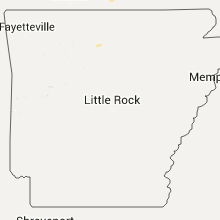
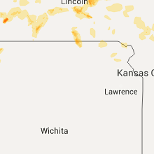
Hail Map for Friday, July 24, 2015

Number of Impacted Households on 7/24/2015
0
Impacted by 1" or Larger Hail
0
Impacted by 1.75" or Larger Hail
0
Impacted by 2.5" or Larger Hail
Square Miles of Populated Area Impacted on 7/24/2015
0
Impacted by 1" or Larger Hail
0
Impacted by 1.75" or Larger Hail
0
Impacted by 2.5" or Larger Hail


Cities Most Affected by Hail Storms of 7/24/2015
| Hail Size | Demographics of Zip Codes Affected | ||||||
|---|---|---|---|---|---|---|---|
| City | Count | Average | Largest | Pop Density | House Value | Income | Age |
| Ansley, NE | 1 | 1.75 | 1.75 | 3 | $23k | $28.3k | 45.9 |
| Parks, NE | 1 | 1.75 | 1.75 | 1 | $37k | $27.0k | 39.6 |
Hail and Wind Damage Spotted on 7/24/2015
Filter by Report Type:Hail ReportsWind Reports
States Impacted
Minnesota, New York, Iowa, Missouri, Alabama, Florida, Kansas, Nebraska, Georgia, Rhode Island, Colorado, Wyoming, Mississippi, South Dakota, Wisconsin, UtahMinnesota
| Local Time | Report Details |
|---|---|
| 7:00 AM CDT | 1 ft diameter tree down and several branches down. pea sized hai in steele county MN, 53.5 miles N of Mason City, IA |
New York
| Local Time | Report Details |
|---|---|
| 2:10 PM EDT | Quarter sized hail reported near Hudson Falls, NY, 38.3 miles NNE of Schenectady, NY, spotter |
| 2:15 PM EDT | Quarter sized hail reported near Hudson Falls, NY, 38.3 miles NNE of Schenectady, NY |
| 2:15 PM EDT | Multiple trees down. time estimated by rada in washington county NY, 38.3 miles NNE of Schenectady, NY |
| 2:17 PM EDT | Quarter sized hail reported near Hudson Falls, NY, 38.3 miles NNE of Schenectady, NY |
| 2:20 PM EDT | Trees dow in washington county NY, 36.5 miles NNE of Schenectady, NY |
| 2:20 PM EDT | Trees and wires down. time estimated by rada in washington county NY, 33.6 miles NNE of Schenectady, NY |
| 2:47 PM EDT | Trees and wires down. time estimated by rada in saratoga county NY, 28.2 miles NNE of Schenectady, NY |
| 3:05 PM EDT | Multiple trees and wires down. time estimated by rada in saratoga county NY, 27 miles NE of Schenectady, NY |
| 3:05 PM EDT | Quarter sized hail reported near Schuylerville, NY, 22.4 miles NE of Schenectady, NY |
| 3:05 PM EDT | Multiple trees down in saratoga county NY, 22.4 miles NE of Schenectady, NY |
| 3:05 PM EDT | Trees and wires down in washington county NY, 27.4 miles NE of Schenectady, NY |
| 3:20 PM EDT | Trees and wires down. time estimated by rada in washington county NY, 29.5 miles NE of Schenectady, NY |
| 3:20 PM EDT | Trees down. time estimated by rada in saratoga county NY, 21.9 miles NE of Schenectady, NY |
| 3:31 PM EDT | Trees down. time estimated by rada in saratoga county NY, 18 miles ENE of Schenectady, NY |
Iowa
| Local Time | Report Details |
|---|---|
| 1:15 PM CDT | 20 inch diameter tree down. large limbs down. torrential rai in wapello county IA, 52.5 miles NW of Kahoka, MO |
| 1:20 PM CDT | Winds estimated 50 to 60 mp in van buren county IA, 38.4 miles NW of Kahoka, MO |
| 1:27 PM CDT | Camper turned at rathbun lake...island view park. time estimated per rada in appanoose county IA, 63.7 miles SE of Des Moines, IA |
| 1:35 PM CDT | Appanoose co sheriff reported power lines and tree down in town. time estimate in appanoose county IA, 64.2 miles WNW of Kahoka, MO |
| 1:45 PM CDT | 4 inch tree branches down in appanoose county IA, 53.4 miles WNW of Kahoka, MO |
| 1:45 PM CDT | Trees down on 205th street in pittsburg. time estimated from rada in van buren county IA, 27.4 miles NNW of Kahoka, MO |
| 1:46 PM CDT | Guessing at least 100 trees down in keosauqua. time estimated from rada in van buren county IA, 24.8 miles NNW of Kahoka, MO |
| 1:47 PM CDT | Trees down near intersection of route j40 and highway 1. time estimated from rada in van buren county IA, 22.8 miles NNW of Kahoka, MO |
| 7:42 PM CDT | Storm damage reported in mills county IA, 18.2 miles SSE of Omaha, NE |
| 2:05 AM CDT | Storm damage reported in page county IA, 45.6 miles SE of Omaha, NE |
Missouri
| Local Time | Report Details |
|---|---|
| 2:35 PM CDT | 4 inch tree limbs torn out of tre in sullivan county MO, 62.3 miles W of Kahoka, MO |
| 3:45 PM CDT | A 5th wheel camper was blown over at the same location on badger street as the previous repor in macon county MO, 62.1 miles NNW of Columbia, MO |
| 3:45 PM CDT | Macon county dispatch relayed report of approximately 60 to 70 mph winds in macon county MO, 61.3 miles NNW of Columbia, MO |
| 5:27 PM CDT | A tree was downed blocking a road near bunceton. time estimated by rada in cooper county MO, 26.5 miles WSW of Columbia, MO |
| 6:30 PM CDT | 12 inch diamer trees down along with powerlines in the stover and southwest versailles area in morgan county MO, 50 miles SW of Columbia, MO |
| 7:30 PM CDT | Trees and powerlines down in laclede county MO, 46 miles NE of Springfield, MO |
| 7:40 PM CDT | Three trees down on highway 9 in douglas county MO, 57.2 miles ESE of Springfield, MO |
| 7:54 PM CDT | Numerous 8-10 inch limbs down at highway 64 and highway ra in hickory county MO, 42.1 miles N of Springfield, MO |
| 8:04 PM CDT | 4 to 8 inch diameter trees blown down in polk are in polk county MO, 35.9 miles N of Springfield, MO |
| 8:10 PM CDT | Limbs down out of trees. 60mph estimated wind gusts in polk county MO, 17.5 miles NNE of Springfield, MO |
| 8:10 PM CDT | Severe thunderstorm wind gusts downed a large limb at a home 5 miles west of marshfiel in webster county MO, 18.4 miles ENE of Springfield, MO |
| 8:10 PM CDT | Several tree limbs down in ozark county MO, 67.6 miles SE of Springfield, MO |
| 8:27 PM CDT | Sustained 40-45 mph with gusts to 60 mph reported at farm road 84 and hwy 12 in greene county MO, 10.7 miles ENE of Springfield, MO |
| 8:30 PM CDT | On county line we have damage to our repeater site antenna is bent over. large limbs down on hwy 14. time estimated based on rada in douglas county MO, 28 miles ESE of Springfield, MO |
| 8:39 PM CDT | Tree down at krbk in east springfield. limbs fallen on power lines in greene county MO, 0.6 miles S of Springfield, MO |
| 8:40 PM CDT | Large tree on roadway at 6600 block and e fr 13 in greene county MO, 7.3 miles E of Springfield, MO |
| 8:40 PM CDT | Estimated wind gust of 70 mph. lost a patio canop in webster county MO, 14.2 miles ESE of Springfield, MO |
| 8:40 PM CDT | Estimated wind gusts of 60 mph. minor tree damag in christian county MO, 11.7 miles S of Springfield, MO |
| 8:47 PM CDT | Estimated wind gusts of 60 mph. minor tree damage. time corrected based on radar dat in christian county MO, 11.7 miles S of Springfield, MO |
| 8:47 PM CDT | On county line we have damage to our repeater site antenna is bent over. large limbs down on hwy 14. time estimated based on radar. correct time based on radar estimate in douglas county MO, 28 miles ESE of Springfield, MO |
| 8:50 PM CDT | 10 inch tree reported down across hwy 12 in greene county MO, 9.6 miles E of Springfield, MO |
| 8:55 PM CDT | Two trees down in mansfield. one fell on porch located close to highway 60 and business 5 by signal statio in wright county MO, 39.9 miles E of Springfield, MO |
| 8:55 PM CDT | Large tree limb fell down on a vehicle in ozark county MO, 70 miles SE of Springfield, MO |
| 8:56 PM CDT | 60 to 70 mph estimated wind gusts. furniture blew off deck with some tree and property damag in christian county MO, 18.6 miles SE of Springfield, MO |
| 8:56 PM CDT | Tree down on hwy 5 one mile north of mansfield. partly blocking the highwa in wright county MO, 39.7 miles E of Springfield, MO |
| 9:12 PM CDT | Powerline down at apricot lane in crane as well as a large tree down across medical spring in stone county MO, 25.7 miles SW of Springfield, MO |
| 9:17 PM CDT | Winds estimated at 50 to 60 mph and still increasing at the time of the repor in taney county MO, 35.7 miles SSE of Springfield, MO |
| 9:20 PM CDT | Tree down blocking both lanes at 4600 block of state hwy d in stone county MO, 35.4 miles S of Springfield, MO |
| 9:22 PM CDT | Tree down on abesville circle in stone county MO, 25.2 miles S of Springfield, MO |
| 9:26 PM CDT | Several 2-3 inch limbs down in stone county MO, 30.3 miles SSW of Springfield, MO |
| 9:30 PM CDT | Good size pieces of trees knocked dow in stone county MO, 40.6 miles S of Springfield, MO |
| 9:40 PM CDT | Power line blown down in downtown branson in taney county MO, 39.4 miles S of Springfield, MO |
| 11:45 PM CDT | Quarter sized hail reported near Coffey, MO, 75.9 miles NNE of Kansas City, MO |
| 11:45 PM CDT | Numerous limbs down in daviess county MO, 75.9 miles NNE of Kansas City, MO |
Alabama
| Local Time | Report Details |
|---|---|
| 3:24 PM CDT | Large tree snapped in half near ross clark circle. photo viewed via social medi in houston county AL, 81.4 miles NE of Miramar Beach, FL |
Florida
| Local Time | Report Details |
|---|---|
| 4:00 PM CDT | Tree down on anderson roa in jackson county FL, 61.9 miles WNW of Tallahassee, FL |
| 6:43 PM EDT | Powerlines down at capital circle ne and miccosukee in leon county FL, 3.7 miles NE of Tallahassee, FL |
| 6:43 PM EDT | Fhp reports tree in the road at us 319 and cr 1 in leon county FL, 17.4 miles NNE of Tallahassee, FL |
| 6:50 PM EDT | Large tree snapped in emerald woods subdivisio in leon county FL, 10.9 miles NE of Tallahassee, FL |
| 7:02 PM EDT | Tree down on tram roa in leon county FL, 9.2 miles ESE of Tallahassee, FL |
Kansas
| Local Time | Report Details |
|---|---|
| 4:10 PM CDT | Quarter sized hail reported near Atwood, KS, 34.7 miles N of Colby, KS, nickel to quarter size hail. |
| 4:23 PM CDT | Quarter sized hail reported near Atwood, KS, 34.1 miles N of Colby, KS, dime to quarter size hail. |
| 4:51 PM CDT | Quarter sized hail reported near Ludell, KS, 30.6 miles NNE of Colby, KS, mostly pea to dime size hail with some quarter. relayed via the spotter network. |
| 6:37 PM CDT | Quarter sized hail reported near Bird City, KS, 35.5 miles NW of Colby, KS, mostly dime size hail. |
| 7:09 PM CDT | Recorded at grace flying service in st. francis in cheyenne county KS, 47.8 miles WNW of Colby, KS |
| 7:10 PM CDT | Storm damage reported in cheyenne county KS, 47.8 miles WNW of Colby, KS |
| 7:11 PM CDT | Half Dollar sized hail reported near Saint Francis, KS, 47.8 miles WNW of Colby, KS, the hail broke a few windows on the south side of the court house in st. francis. |
| 7:11 PM CDT | Ping Pong Ball sized hail reported near Saint Francis, KS, 49.9 miles WNW of Colby, KS, spotter reported that the 1.5 inch hail was shaped like frisbees. estimated winds of at least 60 mph. |
| 9:04 PM CDT | Quarter sized hail reported near Stockton, KS, 39.4 miles N of Hays, KS |
Nebraska
| Local Time | Report Details |
|---|---|
| 4:25 PM CDT | Quarter sized hail reported near Chapman, NE, 9.8 miles NE of Grand Island, NE |
| 7:50 PM CDT | 8 to 10 inch trees blown ove in cass county NE, 17.5 miles S of Omaha, NE |
| 7:52 PM CDT | In addition to the strong winds...small hail and torrential rainfall was occurrin in lincoln county NE, 28 miles SE of North Platte, NE |
| 7:00 PM MDT | Golf Ball sized hail reported near Parks, NE, 57.4 miles ENE of Yuma, CO, hail up to golf ball size. |
| 7:05 PM MDT | Ping Pong Ball sized hail reported near Benkelman, NE, 58.9 miles ENE of Yuma, CO |
| 8:48 PM CDT | Golf Ball sized hail reported near Ansley, NE, 58.9 miles WNW of Grand Island, NE, one window was broken out at the residents from the golf ball size hail. |
| 8:54 PM CDT | Quarter sized hail reported near Ansley, NE, 56.1 miles WNW of Grand Island, NE |
| 8:56 PM CDT | Quarter sized hail reported near Ansley, NE, 54.7 miles WNW of Grand Island, NE |
| 8:56 PM CDT | Quarter sized hail reported near Arcadia, NE, 60.4 miles WNW of Grand Island, NE |
| 9:10 PM CDT | Quarter sized hail reported near Arcadia, NE, 54.3 miles NW of Grand Island, NE |
| 9:25 PM CDT | Via social media... snapped flag pole and some tree damage in merrick county NE, 12.1 miles ENE of Grand Island, NE |
| 9:25 PM CDT | Ping Pong Ball sized hail reported near Heartwell, NE, 34 miles SW of Grand Island, NE, report via social media |
| 10:12 PM CDT | Storm damage reported in hall county NE, 1.6 miles WSW of Grand Island, NE |
| 10:15 PM CDT | Shingles blowing off roofs of businesse in hall county NE, 1.6 miles WSW of Grand Island, NE |
| 10:27 PM CDT | Storm damage reported in hall county NE, 3.3 miles NNE of Grand Island, NE |
| 10:34 PM CDT | Multiple tree branches down. some branches approximately 4 feet lon in hall county NE, 1.6 miles WSW of Grand Island, NE |
| 10:43 PM CDT | Via social media... snapped flag pole and some tree damage. corrected time. time est fm rada in merrick county NE, 12.1 miles ENE of Grand Island, NE |
| 10:55 PM CDT | Reports of tree dmg. size unknown. power out in parts of the city. used time of 54 mph gust from awo in hamilton county NE, 18.2 miles ESE of Grand Island, NE |
| 11:04 PM CDT | A few 3 inch diameter tree limbs down with a lot of inch and smaller diameter branches down. no damage to buildings. no large tree limbs or entire trees down. relayed b in clay county NE, 33.2 miles SE of Grand Island, NE |
| 11:05 PM CDT | Storm damage reported in york county NE, 31.2 miles ESE of Grand Island, NE |
| 11:35 PM CDT | Storm damage reported in york county NE, 37.7 miles E of Grand Island, NE |
| 12:10 AM CDT | Ping Pong Ball sized hail reported near Lincoln, NE, 49 miles SW of Omaha, NE, measured 1.5 inch hail on the southeast side of the city of lincoln. |
| 12:11 AM CDT | Storm damage reported in lancaster county NE, 49.6 miles SW of Omaha, NE |
| 12:15 AM CDT | Storm damage reported in lancaster county NE, 53 miles WSW of Omaha, NE |
| 12:19 AM CDT | Wind gusts estimated of at least 70 mp in seward county NE, 61.1 miles WSW of Omaha, NE |
| 12:28 AM CDT | Spotter reported small tree limbs down... less than 2 inches in diamter... as well as pea size hai in lancaster county NE, 50 miles SW of Omaha, NE |
| 12:31 AM CDT | Peak gust speed and tim in lancaster county NE, 49.6 miles SW of Omaha, NE |
Georgia
| Local Time | Report Details |
|---|---|
| 5:37 PM EDT | Tree down on highway 39 sout in seminole county GA, 44.7 miles NW of Tallahassee, FL |
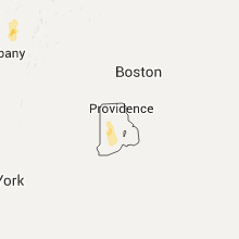
Rhode Island
| Local Time | Report Details |
|---|---|
| 6:10 PM EDT | Quarter sized hail reported near West Greenwich, RI, 19.2 miles SW of Providence, RI |
| 6:30 PM EDT | Quarter sized hail reported near Wyoming, RI, 26 miles SSW of Providence, RI |
| 6:30 PM EDT | Tree down on wires on carolina and nooseneck roa in washington county RI, 28.2 miles SSW of Providence, RI |
| 6:40 PM EDT | Trees down with several roads closed across tow in washington county RI, 26.5 miles SSW of Providence, RI |
Colorado
| Local Time | Report Details |
|---|---|
| 6:25 PM MDT | Ping Pong Ball sized hail reported near Burlington, CO, 50.2 miles SSE of Yuma, CO |
Wyoming
| Local Time | Report Details |
|---|---|
| 7:14 PM MDT | Quarter sized hail reported near Newcastle, WY, 50.9 miles WSW of Rapid City, SD |
| 7:20 PM MDT | A train including ten empty coal cars was derailed due to stong wind gusts. time estimated by rada in weston county WY, 49.9 miles WSW of Rapid City, SD |
| 1:20 AM MDT | Quarter sized hail reported near Gillette, WY, 7.8 miles S of Gillette, WY |
Mississippi
| Local Time | Report Details |
|---|---|
| 8:15 PM CDT | Several reports of trees down around and north of leakesvil in greene county MS, 43.9 miles NW of Mobile, AL |
South Dakota
| Local Time | Report Details |
|---|---|
| 8:04 PM MDT | Quarter sized hail reported near Sturgis, SD, 26.9 miles NNW of Rapid City, SD, ping report |
| 8:13 PM MDT | Quarter sized hail reported near Custer, SD, 27.4 miles SW of Rapid City, SD, ping report |
| 8:14 PM MDT | Quarter sized hail reported near Custer, SD, 27.7 miles SW of Rapid City, SD |
| 8:14 PM MDT | Ping Pong Ball sized hail reported near Custer, SD, 27.7 miles SW of Rapid City, SD, report via twitter |
| 8:19 PM MDT | Quarter sized hail reported near Custer, SD, 24.2 miles SW of Rapid City, SD |
| 8:25 PM MDT | Quarter sized hail reported near Spearfish, SD, 45.7 miles WNW of Rapid City, SD, mostly dime size and smaller. ground covered in hail. |
| 8:35 PM MDT | Quarter sized hail reported near Custer, SD, 23.1 miles SSW of Rapid City, SD |
| 8:56 PM MDT | Quarter sized hail reported near Rapid City, SD, 10.4 miles S of Rapid City, SD, ground completely covered in hail |
| 8:56 PM MDT | Quarter sized hail reported near Hermosa, SD, 21.7 miles S of Rapid City, SD, ground completely covered in hail |
| 9:25 PM MDT | Quarter sized hail reported near Union Center, SD, 53.2 miles NNE of Rapid City, SD |
| 2:35 AM MDT | Storm damage reported in butte county SD, 54.3 miles NW of Rapid City, SD |
| 4:32 AM MDT | Storm damage reported in meade county SD, 89.2 miles NE of Rapid City, SD |
Wisconsin
| Local Time | Report Details |
|---|---|
| 10:20 PM CDT | Trees and fences reported dow in chippewa county WI, 82.3 miles N of La Crosse, WI |
| 10:25 PM CDT | Trees and power lines dow in chippewa county WI, 77.5 miles N of La Crosse, WI |
Utah
| Local Time | Report Details |
|---|---|
| 9:40 PM MDT | Diddle knoll sensor dpg27 in tooele county UT, 67 miles W of Salt Lake City, UT |
Connect with Interactive Hail Maps