

Hail Map for Saturday, July 9, 2016

Number of Impacted Households on 7/9/2016
0
Impacted by 1" or Larger Hail
0
Impacted by 1.75" or Larger Hail
0
Impacted by 2.5" or Larger Hail
Square Miles of Populated Area Impacted on 7/9/2016
0
Impacted by 1" or Larger Hail
0
Impacted by 1.75" or Larger Hail
0
Impacted by 2.5" or Larger Hail


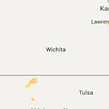


Cities Most Affected by Hail Storms of 7/9/2016
| Hail Size | Demographics of Zip Codes Affected | ||||||
|---|---|---|---|---|---|---|---|
| City | Count | Average | Largest | Pop Density | House Value | Income | Age |
| Northwood, ND | 3 | 2.08 | 2.50 | 3 | $59k | $35.5k | 45.1 |
| Churchs Ferry, ND | 1 | 2.50 | 2.50 | 1 | $44k | $43.8k | 53.4 |
| Lawton, ND | 1 | 2.00 | 2.00 | 1 | $40k | $24.3k | 49.8 |
| Mc Intosh, SD | 1 | 2.00 | 2.00 | 0 | $12k | $25.8k | 49.3 |
| Petersburg, ND | 1 | 1.75 | 1.75 | 1 | $52k | $31.8k | 48.3 |
| Cherokee, OK | 1 | 1.75 | 1.75 | 8 | $33k | $30.3k | 45.3 |
| Georgetown, SC | 1 | 1.75 | 1.75 | 58 | $87k | $32.1k | 40.3 |
| Leeds, ND | 1 | 1.75 | 1.75 | 1 | $38k | $32.2k | 49.9 |
| Michigan, ND | 1 | 1.75 | 1.75 | 1 | $28k | $32.0k | 50.6 |
| Pritchett, CO | 1 | 1.75 | 1.75 | 0 | $27k | $30.9k | 45.7 |
| Hendrum, MN | 1 | 1.75 | 1.75 | 3 | $41k | $35.1k | 41.2 |
| Hatton, ND | 1 | 1.75 | 1.75 | 6 | $55k | $35.6k | 45.5 |
| Hillsboro, ND | 1 | 1.75 | 1.75 | 8 | $64k | $36.0k | 41.3 |
| Jamestown, ND | 1 | 1.75 | 1.75 | 39 | $71k | $33.6k | 42.3 |
| Larimore, ND | 1 | 1.75 | 1.75 | 4 | $67k | $36.7k | 41.8 |
Hail and Wind Damage Spotted on 7/9/2016
Filter by Report Type:Hail ReportsWind Reports
States Impacted
South Carolina, Oklahoma, New York, Georgia, Tennessee, Alabama, Pennsylvania, Texas, Mississippi, North Dakota, Montana, Missouri, South Dakota, New Jersey, Colorado, Idaho, MinnesotaSouth Carolina
| Local Time | Report Details |
|---|---|
| 11:05 AM EDT | Numerous trees down...including one on a garage...in the carolina bay subdivision of west ashely in charleston county SC, 27.6 miles S of Charleston, SC |
| 11:11 AM EDT | At least two large limbs down near the 500 block of stinson drive. time estimated based on rada in charleston county SC, 28 miles S of Charleston, SC |
| 11:19 AM EDT | Twitter report of multiple trees down...including one blocking maybank highway and on powerlines near the interesction of woodland shores rd on james island in charleston county SC, 30.1 miles S of Charleston, SC |
| 11:19 AM EDT | Report of a large tree down across rushland landing rd on johns island...blocking access to the neighborhood in charleston county SC, 30.1 miles S of Charleston, SC |
| 3:38 PM EDT | Tree reported down near the intersection of plantation dr and blue grouse pt. time estimated based on rada in jasper county SC, 13.2 miles N of Savannah, GA |
| 3:42 PM EDT | Tree reported down near the intersection of heritage rd with grays hwy. time estimated based on rada in jasper county SC, 40.8 miles N of Savannah, GA |
| 3:47 PM EDT | Tree reported down near the intersection of bellinger hill rd with s okatie hwy. time estimated based on rada in jasper county SC, 7.7 miles NNE of Savannah, GA |
| 3:55 PM EDT | Tree reported down on hwy 17 about 2 miles north of gardens corner. time estimated based on rada in beaufort county SC, 41.6 miles NNE of Savannah, GA |
| 3:55 PM EDT | Tree reported down on trask pkwy at the intersection with hwy 17. time estimated based on rada in beaufort county SC, 40.7 miles NNE of Savannah, GA |
| 4:00 PM EDT | Trained spotter reports a tree down across may river rd just east of bolden rd in beaufort county SC, 14.3 miles NE of Savannah, GA |
| 4:02 PM EDT | Warning point reported tree went through top of house at 70 block on crosstree drive nort in beaufort county SC, 20.6 miles ENE of Savannah, GA |
| 5:35 PM EDT | Tree reported down on longridge rd near the intersection with wassamassaw lane. time estimated based on rada in berkeley county SC, 9.1 miles WSW of Charleston, SC |
| 6:30 PM EDT | Golf Ball sized hail reported near Georgetown, SC, 51.5 miles ENE of Charleston, SC, a retired meteorologist reported golf ball size hail on debordieu boulevard. the hail lasted for 10 minutes. |
| 7:01 PM EDT | Reports of trees and powerlines down across andrews...on jones ave...park st...and s rosemary ave. time estimated by rada in georgetown county SC, 31.1 miles ENE of Charleston, SC |
| 7:40 PM EDT | Quarter sized hail reported near Myrtle Beach, SC, 64 miles ENE of Charleston, SC, report of quarter size hail near intersection of bay rd and enterprise rd. hail lasted for 10 minutes. |
| 7:45 PM EDT | Quarter sized hail reported near Myrtle Beach, SC, 64.3 miles ENE of Charleston, SC, law enforcement reports quarter size hail. |
| 7:45 PM EDT | Quarter sized hail reported near Myrtle Beach, SC, 63.8 miles ENE of Charleston, SC, report of quarter size hail on east sweet briar trail. |
| 7:54 PM EDT | Quarter sized hail reported near Myrtle Beach, SC, 64.5 miles ENE of Charleston, SC, report of quarter size hail near intersection of sc 707 and bay rd. |
Oklahoma
| Local Time | Report Details |
|---|---|
| 10:30 AM CDT | Several trees and limbs downed by damaging winds. power pole was snapped. damage reported near n3750 roa in coal county OK, 17.5 miles NW of Atoka, OK |
| 6:50 PM CDT | Golf Ball sized hail reported near Cherokee, OK, 61.4 miles ENE of Woodward, OK |
| 7:05 PM CDT | Quarter sized hail reported near Cherokee, OK, 62.3 miles ENE of Woodward, OK |
New York
| Local Time | Report Details |
|---|---|
| 12:15 PM EDT | Trees down...dock flipped over on raquette river...pontoon boats flipped ove in st. lawrence county NY, 29.1 miles ESE of Ogdensburg, NY |
| 2:31 PM EDT | A few trees down...power lines down in st. lawrence county NY, 25.7 miles ENE of Ogdensburg, NY |
Georgia
| Local Time | Report Details |
|---|---|
| 1:30 PM EDT | One tree down along highway 31 in harris county GA, 35.3 miles E of Auburn, AL |
| 2:05 PM EDT | Serveral trees were reported down along d street by the 911 cente in harris county GA, 39.9 miles ENE of Auburn, AL |
| 2:16 PM EDT | Tree reported down on powerlines near the intersection of burkhalter rd and hwy 67. time estimated based on rada in bulloch county GA, 44.9 miles WNW of Savannah, GA |
| 2:30 PM EDT | Serveral trees were reported down along d street by the 911 cente in harris county GA, 40.8 miles ENE of Auburn, AL |
| 2:55 PM EDT | Many trees reported down across the town of clyo. time estimated based on rada in effingham county GA, 29.4 miles NNW of Savannah, GA |
| 3:12 PM EDT | Tree reported down near the intersection of rahn station rd at lewis rahn rd. time estimated based on rada in effingham county GA, 20.1 miles NNW of Savannah, GA |
| 3:27 PM EDT | Two trees were blown down on highway 42 near maynards mill r in monroe county GA, 59.8 miles SSE of Atlanta, GA |
| 3:28 PM EDT | A tree was downed on hwy 137 near the county lin in taylor county GA, 65.5 miles E of Auburn, AL |
| 3:45 PM EDT | Multiple trees reported down just north of idea in macon county GA, 76.9 miles E of Auburn, AL |
| 3:56 PM EDT | Trees were blown down on vineville avenu in bibb county GA, 75 miles SE of Atlanta, GA |
| 3:59 PM EDT | A tree was blown down on sugarloaf circle...clipping the back of a hom in bibb county GA, 74.1 miles SE of Atlanta, GA |
| 4:00 PM EDT | A traffic light was blown down at north avenue and gray highwa in bibb county GA, 76.3 miles SE of Atlanta, GA |
| 4:18 PM EDT | The terrell county 911 center reported one tree down on cooper drive n in terrell county GA, 83.5 miles SE of Auburn, AL |
| 6:00 PM EDT | Several trees were downed on highway 441. one tree temporarily blocked the highwa in telfair county GA, 26.1 miles NNW of Douglas, GA |
| 6:00 PM EDT | Report of trees down and a blown transformer in miller county GA, 60.8 miles NNW of Tallahassee, FL |
| 6:42 PM EDT | Media shared photos of two trees down and a flipped irrigation pivot in turner county in turner county GA, 41.7 miles WNW of Douglas, GA |
| 7:00 PM EDT | Emergency manager reported 4 trees dow in bacon county GA, 23.7 miles ENE of Douglas, GA |
| 7:10 PM EDT | Multiple trees were blown down along highway 36 near star in butts county GA, 38.1 miles SE of Atlanta, GA |
Tennessee
| Local Time | Report Details |
|---|---|
| 12:49 PM CDT | Tree down in driveway at 1119 madison creek road in goodlettsville in sumner county TN, 14.3 miles NNE of Nashville, TN |
Alabama
| Local Time | Report Details |
|---|---|
| 1:15 PM CDT | Tree down on intersection of cr12 and cr29 est wind speed at 40-50mph in cherokee county AL, 67.7 miles WNW of Atlanta, GA |
| 2:20 PM CDT | Power lines down at 835 egypt road...est wind speed 40-50mph in etowah county AL, 52.9 miles NE of Birmingham, AL |
| 2:34 PM CDT | Gadsden asos reports tstm wind gust at 51kts and 42kts sustained in etowah county AL, 51.8 miles NE of Birmingham, AL |
| 4:15 PM CDT | Large tree limbs/branches down greater than 2in in blount county AL, 42.6 miles NE of Birmingham, AL |
| 4:18 PM CDT | *** 1 inj *** tree down on structure at 1841 st.charles street...1 injury reported in jefferson county AL, 4.4 miles SW of Birmingham, AL |
| 4:19 PM CDT | Power lines down on pike road in jefferson county AL, 4.7 miles WSW of Birmingham, AL |
| 4:19 PM CDT | Power lines down on lown ave in jefferson county AL, 5.7 miles SW of Birmingham, AL |
| 4:20 PM CDT | Power lines down on alabama ave and 16 ave in jefferson county AL, 3.5 miles SW of Birmingham, AL |
| 4:45 PM CDT | Reports of trees down along hwy 427 in coffee county AL, 65.3 miles NNE of Miramar Beach, FL |
| 4:45 PM CDT | Reports trees down along hwy 189 n. between kingston and elb in coffee county AL, 66.9 miles NNE of Miramar Beach, FL |
| 5:24 PM CDT | Tree down on hwy 69n near boldo in walker county AL, 31.1 miles NW of Birmingham, AL |
| 5:42 PM CDT | Tree down on viking dr and 20th ave in walker county AL, 33.5 miles NW of Birmingham, AL |
| 6:35 PM CDT | Report of tree down over power line in ashford in houston county AL, 77 miles NW of Tallahassee, FL |
| 7:21 PM CDT | Two trees were knocked down along langston road near the water plant. time estimated by rada in jackson county AL, 50.8 miles SW of Chattanooga, TN |
Pennsylvania
| Local Time | Report Details |
|---|---|
| 3:00 PM EDT | Trees down in chester county PA, 66.6 miles NNE of Baltimore, MD |
Texas
| Local Time | Report Details |
|---|---|
| 2:05 PM CDT | Wind gust of 59 mph measured at frisco rd and texoma parkwa in grayson county TX, 58 miles SSW of Atoka, OK |
| 2:05 PM CDT | 60 mph wind gust reported in denison in grayson county TX, 50.1 miles SSW of Atoka, OK |
| 2:36 PM CDT | Trained spotter reports 60 mph wind gust at hwy 11 and dewey in shouthern sherma in grayson county TX, 58 miles SSW of Atoka, OK |
| 4:05 PM CDT | Large tree branches down at the intersection of collins rd and cleveland rd in dento in denton county TX, 36.8 miles NW of Dallas, TX |
| 4:23 PM CDT | Fort worth/alliance asos reports gust of 51 kts in tarrant county TX, 34.6 miles WNW of Dallas, TX |
| 4:33 PM CDT | 60 mph wind gust reported at dallas north tollway and nw hw in dallas county TX, 1.1 miles ESE of Dallas, TX |
| 4:36 PM CDT | 65 mph wind gust reported at moore/sandy lake in coppel in dallas county TX, 17.6 miles NW of Dallas, TX |
| 4:50 PM CDT | Bowie vfd reports estimated wind of 60 mph in montague county TX, 44.1 miles ESE of Wichita Falls, TX |
| 7:13 PM CDT | Also reduced visibility due to flying dust in baylor county TX, 51 miles WSW of Wichita Falls, TX |
| 8:37 PM CDT | Small shed overturned and a section of fence down at the intersection of fm 1082 and cr 327 in jones county TX, 11.2 miles N of Abilene, TX |
Mississippi
| Local Time | Report Details |
|---|---|
| 3:07 PM CDT | Tree down aross old hwy 8 in webster county MS, 30.5 miles W of Starkville, MS |
| 3:55 PM CDT | Tree down across hwy 3 in carroll county MS, 61.1 miles W of Starkville, MS |
| 4:10 PM CDT | Tree down across main stree in leake county MS, 46.9 miles ENE of Jackson, MS |
| 4:33 PM CDT | Ping Pong Ball sized hail reported near Little Rock, MS, 68.2 miles S of Starkville, MS, off ms hwy 494... accompanied by high winds. reported via social media |
| 6:42 PM CDT | Sereral sheds blown down with one shed blown into a house on salum rd. tree down in the pleasant grove communit in wayne county MS, 74.5 miles NW of Mobile, AL |
North Dakota
| Local Time | Report Details |
|---|---|
| 3:14 PM CDT | Quarter sized hail reported near Esmond, ND, 42 miles W of Devils Lake, ND |
| 3:25 PM CDT | Half Dollar sized hail reported near Oberon, ND, 25.2 miles WSW of Devils Lake, ND |
| 3:49 PM CDT | Golf Ball sized hail reported near Leeds, ND, 29.6 miles WNW of Devils Lake, ND |
| 4:20 PM CDT | Quarter sized hail reported near Devils Lake, ND, 0.6 miles WSW of Devils Lake, ND |
| 4:28 PM CDT | Tennis Ball sized hail reported near Churchs Ferry, ND, 22.3 miles NW of Devils Lake, ND, lots of 2 inch diameter covering the ground. largest hailstones measured at 2.25 inch diameter. report by trainer spotter/storm chaser. |
| 4:55 PM CDT | Half Dollar sized hail reported near Webster, ND, 12 miles NNE of Devils Lake, ND, lots of quarter of half dollar sized hail. hailed ended by 5 pm cdt. |
| 5:05 PM CDT | Hen Egg sized hail reported near Lawton, ND, 17.5 miles NE of Devils Lake, ND, mainly quarter to ping pong ball sized hail. some larger than a golfball. |
| 5:25 PM CDT | Quarter sized hail reported near Starkweather, ND, 29.6 miles N of Devils Lake, ND, hail fell along the ramsey and cavalier county line. |
| 5:45 PM CDT | Ping Pong Ball sized hail reported near Webster, ND, 17.9 miles N of Devils Lake, ND, mainly quarter to half dollar sized hail with some up to ping pong ball sized. large hail occurred intermittently between 540 and 545 pm cdt. |
| 6:10 PM CDT | Half Dollar sized hail reported near Brocket, ND, 18.3 miles ENE of Devils Lake, ND |
| 6:12 PM CDT | Quarter sized hail reported near Larimore, ND, 47.9 miles ESE of Devils Lake, ND, wall cloud visible to southwest moving into grand forks county. |
| 6:19 PM CDT | Quarter sized hail reported near Hampden, ND, 28.4 miles NNE of Devils Lake, ND |
| 6:20 PM CDT | Quarter sized hail reported near Gilby, ND, 56.8 miles E of Devils Lake, ND, lots of dime sized hail. some up to quater sized. |
| 6:21 PM CDT | Quarter sized hail reported near Brocket, ND, 21.7 miles ENE of Devils Lake, ND, dime to quarter sized hail. |
| 6:21 PM CDT | Quarter sized hail reported near Brocket, ND, 24 miles ENE of Devils Lake, ND, dime to quarter sized hail. |
| 6:25 PM CDT | Quarter sized hail reported near Hampden, ND, 29.5 miles NNE of Devils Lake, ND |
| 6:46 PM CDT | Golf Ball sized hail reported near Michigan, ND, 34.6 miles E of Devils Lake, ND, mostly quarter sized hail with several golf balls. |
| 6:50 PM CDT | Golf Ball sized hail reported near Petersburg, ND, 40.3 miles E of Devils Lake, ND, 10 minute period of golf ball hail ended 700 pm. |
| 7:12 PM CDT | Quarter sized hail reported near Larimore, ND, 47.9 miles ESE of Devils Lake, ND, wall cloud visible to southwest moving into grand forks county. |
| 7:30 PM CDT | Golf Ball sized hail reported near Larimore, ND, 58.6 miles ESE of Devils Lake, ND |
| 7:40 PM CDT | Quarter sized hail reported near Larimore, ND, 61.7 miles ESE of Devils Lake, ND |
| 7:50 PM CDT | Golf Ball sized hail reported near Northwood, ND, 65.1 miles ESE of Devils Lake, ND |
| 7:55 PM CDT | Hen Egg sized hail reported near Northwood, ND, 65.1 miles ESE of Devils Lake, ND |
| 8:04 PM CDT | Quarter sized hail reported near Hatton, ND, 61.7 miles NNW of Fargo, ND, picture and report posted via social media. |
| 8:09 PM CDT | Tennis Ball sized hail reported near Northwood, ND, 64.4 miles ESE of Devils Lake, ND, numerous tennis ball size hail leading to heavy tree defoliage damage. |
| 8:12 PM CDT | Golf Ball sized hail reported near Hatton, ND, 63.3 miles NNW of Fargo, ND, lots of golf ball sized hail and very heavy rain and wind. |
| 8:20 PM CDT | Ping Pong Ball sized hail reported near Buxton, ND, 54.2 miles NNW of Fargo, ND |
| 8:30 PM CDT | Half Dollar sized hail reported near Buxton, ND, 52.2 miles NNW of Fargo, ND |
| 7:33 PM MDT | Half Dollar sized hail reported near Carson, ND, 58.5 miles SW of Bismarck, ND, 50 mph winds also reported. |
| 8:35 PM CDT | Deputy reports severe winds impacting interstate 29 near mp11 in traill county ND, 48.3 miles NNW of Fargo, ND |
| 8:38 PM CDT | Peak wind measured at a personal weather statio in steele county ND, 54.2 miles NW of Fargo, ND |
| 8:45 PM CDT | Golf Ball sized hail reported near Hillsboro, ND, 38.5 miles NNW of Fargo, ND, damage to vehicle windshields has been observed. |
| 8:55 PM CDT | Quarter sized hail reported near Carrington, ND, 46.7 miles SSW of Devils Lake, ND, 40 mph winds also reported. |
| 7:57 PM MDT | Ping Pong Ball sized hail reported near Raleigh, ND, 49.4 miles SSW of Bismarck, ND |
| 7:57 PM MDT | Storm damage reported in grant county ND, 49.4 miles SSW of Bismarck, ND |
| 9:30 PM CDT | Winds gusted near 60 through 950 pm cdt in morton county ND, 30.4 miles SSW of Bismarck, ND |
| 9:45 PM CDT | Winds started around 945 and lasted through 10 pm. pea size hail also reported in morton county ND, 26.7 miles S of Bismarck, ND |
| 9:50 PM CDT | Quarter sized hail reported near Finley, ND, 62.6 miles NW of Fargo, ND, strong winds broke down numerous 1 to 3 inches branches. |
| 9:50 PM CDT | Quarter sized hail reported near Finley, ND, 62.7 miles NW of Fargo, ND, strong winds broke down numerous 1 to 3 inches branches. |
| 11:05 PM CDT | Quarter sized hail reported near Jamestown, ND, 84 miles S of Devils Lake, ND, report via social media. |
| 11:05 PM CDT | Golf Ball sized hail reported near Jamestown, ND, 83.3 miles S of Devils Lake, ND, public report on the northwest side of jamestown relayed through the law enforcement center. |
| 12:10 AM CDT | Quarter sized hail reported near Wahpeton, ND, 42.6 miles S of Fargo, ND, very heavy rains. report posted via social media. |
| 1:00 AM CDT | Peak wind measured at a personal weather statio in sargent county ND, 54 miles NE of Aberdeen, SD |
| 12:04 AM MDT | Storm damage reported in stark county ND, 95.5 miles W of Bismarck, ND |
| 12:11 AM MDT | 63 mph wind gust measured by dickinson ndaw in stark county ND, 95 miles SSE of Williston, ND |
| 12:28 AM MDT | 70 mph wind gusts estimated near exit 72 on interstate 9 in stark county ND, 85 miles W of Bismarck, ND |
| 12:28 AM MDT | Storm damage reported in stark county ND, 81.5 miles W of Bismarck, ND |
Montana
| Local Time | Report Details |
|---|---|
| 3:01 PM MDT | Quarter sized hail reported near Winnett, MT, 90 miles N of Billings, MT |
| 3:12 PM MDT | Storm damage reported in petroleum county MT, 85.8 miles NNE of Billings, MT |
| 5:07 PM MDT | And pea sized hai in garfield county MT, 59.8 miles NW of Miles City, MT |
| 7:24 PM MDT | Small trees bent over. beaufort scale estimate of 55-6 in valley county MT, 28.9 miles W of Glasgow, MT |
| 7:50 PM MDT | Storm damage reported in valley county MT, 24.5 miles WNW of Glasgow, MT |
Missouri
| Local Time | Report Details |
|---|---|
| 4:45 PM CDT | Thunderstorm winds downed a tree across the highwa in shannon county MO, 30.7 miles SSE of Salem, MO |
| 7:50 PM CDT | Quarter sized hail reported near Waynesville, MO, 39.9 miles WNW of Salem, MO, picture of hail near waynesville passed on via social media and amateur radio. |
| 12:03 AM CDT | Severe thunderstorm wind gusts downed a large tree into a power line in the city of cartervill in jasper county MO, 63.5 miles W of Springfield, MO |
South Dakota
| Local Time | Report Details |
|---|---|
| 4:25 PM MDT | Storm damage reported in butte county SD, 44.4 miles NNW of Rapid City, SD |
| 4:50 PM MDT | Also had pea size hail for a few minutes in harding county SD, 82.6 miles N of Rapid City, SD |
| 5:14 PM MDT | Storm damage reported in butte county SD, 61.4 miles N of Rapid City, SD |
| 5:16 PM MDT | Storm damage reported in butte county SD, 71.1 miles N of Rapid City, SD |
| 5:18 PM MDT | Storm damage reported in butte county SD, 64.2 miles N of Rapid City, SD |
| 5:40 PM MDT | Storm damage reported in harding county SD, 88.4 miles N of Rapid City, SD |
| 5:58 PM MDT | Storm damage reported in perkins county SD, 93 miles N of Rapid City, SD |
| 6:20 PM MDT | Storm damage reported in perkins county SD, 106.8 miles NNE of Rapid City, SD |
| 6:35 PM MDT | Storm damage reported in perkins county SD, 106.6 miles SW of Bismarck, ND |
| 6:48 PM MDT | Time estimated from radar in perkins county SD, 102.9 miles SW of Bismarck, ND |
| 6:55 PM MDT | Storm damage reported in perkins county SD, 88.3 miles SW of Bismarck, ND |
| 7:00 PM MDT | Storm damage reported in corson county SD, 78 miles SW of Bismarck, ND |
| 7:15 PM MDT | Hen Egg sized hail reported near Mc Intosh, SD, 68.1 miles SSW of Bismarck, ND, report from earlier this evening. |
| 7:38 PM MDT | 6 foot long...3 inch diameter...tree branch broke off tree when outflow winds hit in ziebach county SD, 93.3 miles NW of Pierre, SD |
| 8:10 PM MDT | Storm damage reported in corson county SD, 66.3 miles S of Bismarck, ND |
| 8:19 PM MDT | Grand river raws. gust time estimated by rada in corson county SD, 83.1 miles S of Bismarck, ND |
| 8:30 PM MDT | Storm damage reported in corson county SD, 68.8 miles S of Bismarck, ND |
| 8:50 PM MDT | Storm damage reported in corson county SD, 73.8 miles S of Bismarck, ND |
| 9:00 PM MDT | Storm damage reported in stanley county SD, 44.2 miles WNW of Pierre, SD |
| 10:08 PM CDT | Small tree branches down. young trees snapped off. tents blown ove in campbell county SD, 66.8 miles SSE of Bismarck, ND |
| 10:40 PM CDT | Storm damage reported in campbell county SD, 72.7 miles SSE of Bismarck, ND |
| 10:49 PM CDT | Half Dollar sized hail reported near Gettysburg, SD, 38.1 miles N of Pierre, SD |
| 11:26 PM CDT | Quarter sized hail reported near Onida, SD, 26.7 miles NNE of Pierre, SD |
| 1:36 AM CDT | Storm damage reported in roberts county SD, 73.6 miles ENE of Aberdeen, SD |
| 1:40 AM CDT | Storm damage reported in roberts county SD, 66.1 miles S of Fargo, ND |
| 1:43 AM CDT | Storm damage reported in roberts county SD, 66.1 miles S of Fargo, ND |
New Jersey
| Local Time | Report Details |
|---|---|
| 6:38 PM EDT | Trees and wires down in greenwich and hopewell twps in cumberland county NJ, 71.2 miles E of Baltimore, MD |
| 6:45 PM EDT | Several downed trees in bridgeton in cumberland county NJ, 74.5 miles E of Baltimore, MD |
| 6:48 PM EDT | Downed trees and wires in cumberland county NJ, 71.4 miles E of Baltimore, MD |
| 6:48 PM EDT | Numerous downed trees reported in fairton in cumberland county NJ, 72.4 miles N of Ocean City, MD |
| 9:57 PM EDT | Some trees down in trenton. time estimated from rada in mercer county NJ, 52 miles SW of Brooklyn, NY |
| 10:13 PM EDT | Some tree limbs down. time estimated from rada in monmouth county NJ, 47.1 miles SW of Brooklyn, NY |
Colorado
| Local Time | Report Details |
|---|---|
| 7:07 PM MDT | Ping Pong Ball sized hail reported near Pritchett, CO, 113.1 miles ESE of Pueblo, CO, . |
| 7:13 PM MDT | Golf Ball sized hail reported near Pritchett, CO, 114 miles ESE of Pueblo, CO, . |
Idaho
| Local Time | Report Details |
|---|---|
| 8:01 PM MDT | Storm damage reported in power county ID, 48.5 miles SW of Idaho Falls, ID |
| 10:50 PM MDT | Kettle butte arl sit in bonneville county ID, 15 miles WNW of Idaho Falls, ID |
| 11:05 PM MDT | Roberts arl sit in jefferson county ID, 17.7 miles NNW of Idaho Falls, ID |
Minnesota
| Local Time | Report Details |
|---|---|
| 9:25 PM CDT | Golf Ball sized hail reported near Hendrum, MN, 25.9 miles N of Fargo, ND, very strong winds bending trees. power outage across area. |
| 9:45 PM CDT | Quarter sized hail reported near Georgetown, MN, 19.2 miles N of Fargo, ND, lots of nickel to quarter sized hail and very strong winds. |
| 10:20 PM CDT | Steel roofing material torn off of dog kennels. steel doors caved in storage buildings. construction trailer blown over and rolled. trees broken down around town. time in clay county MN, 21.9 miles E of Fargo, ND |
| 10:40 PM CDT | Driving rain and very strong winds estimated at 50 to 60 mph. vehicle rockin in clay county MN, 5.4 miles ESE of Fargo, ND |
| 10:45 PM CDT | Report of two large branches broken off an oak tree. posted via social medi in mahnomen county MN, 45 miles ENE of Fargo, ND |
| 11:06 PM CDT | Half Dollar sized hail reported near Audubon, MN, 38 miles E of Fargo, ND |
| 11:35 PM CDT | Large maple tree broken dow in becker county MN, 53.5 miles SW of Bemidji, MN |
| 11:52 PM CDT | Large tree branches broken down. local power out. report via social medi in clay county MN, 15 miles S of Fargo, ND |
| 12:06 AM CDT | Winds estimated at 60 to 70 mph. large branches breaking down. power outage in otter tail county MN, 64.4 miles ESE of Fargo, ND |
| 12:06 AM CDT | Winds estimated at 60 to 70 mph. large branches breaking down. power outage in otter tail county MN, 65.8 miles ESE of Fargo, ND |
| 12:25 AM CDT | Large branches dow in otter tail county MN, 71.2 miles SSW of Bemidji, MN |
| 12:25 AM CDT | Large branches dow in otter tail county MN, 71.5 miles SSW of Bemidji, MN |
| 1:05 AM CDT | Five inch diameter tree limb severed. bird feeder topple in douglas county MN, 77.7 miles N of Montevideo, MN |
| 1:06 AM CDT | Tree limbs down. picnic table flippe in douglas county MN, 77.7 miles N of Montevideo, MN |
| 1:30 AM CDT | Quarter sized hail reported near Hoffman, MN, 58.7 miles N of Montevideo, MN, very strong wind as well. |
Connect with Interactive Hail Maps