

Hail Map for Sunday, June 12, 2016

Number of Impacted Households on 6/12/2016
0
Impacted by 1" or Larger Hail
0
Impacted by 1.75" or Larger Hail
0
Impacted by 2.5" or Larger Hail
Square Miles of Populated Area Impacted on 6/12/2016
0
Impacted by 1" or Larger Hail
0
Impacted by 1.75" or Larger Hail
0
Impacted by 2.5" or Larger Hail


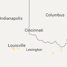


Cities Most Affected by Hail Storms of 6/12/2016
| Hail Size | Demographics of Zip Codes Affected | ||||||
|---|---|---|---|---|---|---|---|
| City | Count | Average | Largest | Pop Density | House Value | Income | Age |
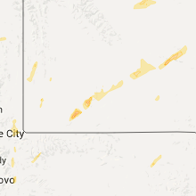
| Wheatland, WY | 3 | 2.00 | 2.50 | 3 | $89k | $35.1k | 47.3 |
| La Junta, CO | 1 | 1.75 | 1.75 | 19 | $69k | $30.5k | 39.2 |
| Rocky Ford, CO | 1 | 1.75 | 1.75 | 19 | $61k | $29.2k | 43.2 |
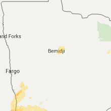
| Hines, MN | 1 | 1.75 | 1.75 | 8 | $73k | $37.7k | 47.1 |
| Waco, TX | 1 | 1.75 | 1.75 | 271 | $55k | $30.6k | 32.4 |
Hail and Wind Damage Spotted on 6/12/2016
Filter by Report Type:Hail ReportsWind Reports
States Impacted
Oklahoma, Minnesota, Missouri, Kansas, Georgia, South Dakota, Wyoming, North Dakota, Virginia, South Carolina, Arkansas, Florida, Kentucky, Louisiana, Colorado, Texas, Nebraska, Utah, IdahoOklahoma
| Local Time | Report Details |
|---|---|
| 7:30 AM CDT | Storm damage reported in stephens county OK, 60.7 miles NE of Wichita Falls, TX |
| 7:35 AM CDT | Storm damage reported in stephens county OK, 60.7 miles NE of Wichita Falls, TX |
| 12:25 PM CDT | Numerous trees dow in ottawa county OK, 64.3 miles SSE of Chanute, KS |
| 8:17 PM CDT | Trees snapped or uprooted... wind estimated at 70 mph by observer... power out in mccurtain county OK, 51 miles W of Nashville, AR |
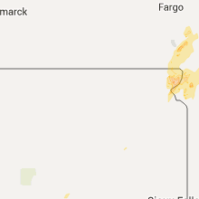
Minnesota
| Local Time | Report Details |
|---|---|
| 10:08 AM CDT | Golf Ball sized hail reported near Hines, MN, 15.9 miles NE of Bemidji, MN |
| 2:33 PM CDT | Quarter sized hail reported near Beardsley, MN, 67.8 miles NW of Montevideo, MN, . |
| 3:08 PM CDT | Quarter sized hail reported near Breckenridge, MN, 48.3 miles SSE of Fargo, ND, a few dime to quarter sized hail. |
| 3:10 PM CDT | Storm damage reported in big stone county MN, 55.8 miles NW of Montevideo, MN |
| 3:15 PM CDT | Grain bin damage at wheaton dumont co-op elevator. time estimated from rada in big stone county MN, 53.8 miles NW of Montevideo, MN |
| 3:47 PM CDT | Half Dollar sized hail reported near Pelican Rapids, MN, 39.1 miles ESE of Fargo, ND, report via social media. |
| 4:05 PM CDT | Quarter sized hail reported near Norcross, MN, 68 miles NNW of Montevideo, MN, numerous nickel to quarter sized hail and very heavy rain. |
| 4:05 PM CDT | Large tree and power lines dow in stevens county MN, 47.2 miles NNW of Montevideo, MN |
| 4:10 PM CDT | Trees topple in stevens county MN, 49.9 miles NNW of Montevideo, MN |
| 5:20 PM CDT | Tree fell over roa in douglas county MN, 68.1 miles NNE of Montevideo, MN |
| 5:30 PM CDT | Quarter sized hail reported near Glenwood, MN, 51 miles NNE of Montevideo, MN, hail lasted until 6 pm with mainly smaller hail noted during this time frame. |
| 5:32 PM CDT | Quarter sized hail reported near Hines, MN, 15.6 miles NE of Bemidji, MN, a few dime to quarter sized hail occurred. |
| 6:00 PM CDT | Numerous large branches felled... some as large as 12 inches in diamete in stearns county MN, 47.8 miles NE of Montevideo, MN |
| 7:00 PM CDT | Doors blown off pole barns. two 18 wheel trailers turned over. information relayed by law enforcemen in chippewa county MN, 2.7 miles NE of Montevideo, MN |
| 7:54 PM CDT | Two inch diameter tree limb severed. time estimated from radar. reported on social medi in mcleod county MN, 54.6 miles W of Minneapolis, MN |
| 8:57 PM CDT | Six inch diameter branches severed near county road 6. time estimated from rada in renville county MN, 33.6 miles SE of Montevideo, MN |
| 8:57 PM CDT | Six inch diameter branches down over country road 6. time estimated from rada in redwood county MN, 33 miles SE of Montevideo, MN |
| 9:19 PM CDT | Six inch diameter branches severed near county road in renville county MN, 33.6 miles SE of Montevideo, MN |
Missouri
| Local Time | Report Details |
|---|---|
| 12:30 PM CDT | Tree down in mcdonald county MO, 80 miles SW of Springfield, MO |
| 1:15 PM CDT | There was a report from social media of shingles blown off a roof on the east side of carthage along with several tree limbs blown down. another report from an official in jasper county MO, 56.2 miles W of Springfield, MO |
| 4:02 PM CDT | Large tree reported down 1 mile east of harrisonvill in cass county MO, 34.1 miles SSE of Kansas City, MO |
| 4:20 PM CDT | Several trees were blown down across highway ff east of av in douglas county MO, 41.7 miles ESE of Springfield, MO |
Kansas
| Local Time | Report Details |
|---|---|
| 12:58 PM CDT | Sustained winds of 50 mp in wichita county KS, 44 miles NNW of Garden City, KS |
| 3:48 PM CDT | 3 inch diameter limb dow in lyon county KS, 55.8 miles NNW of Chanute, KS |
| 12:58 AM CDT | Sustained winds of 50 mp in wichita county KS, 44 miles NNW of Garden City, KS |
| 2:30 AM CDT | 2 power poles down and 4 inch to 6 inch tree branches dow in gray county KS, 34.8 miles SE of Garden City, KS |
Georgia
| Local Time | Report Details |
|---|---|
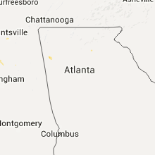
| 3:35 PM EDT | An aluminum carport was removed from its footings and blown several yards awa in floyd county GA, 54.2 miles S of Chattanooga, TN |
| 3:35 PM EDT | Quarter sized hail reported near Rome, GA, 54.2 miles S of Chattanooga, TN, quarter sized hail reported near coosa on alabama highway. |
South Dakota
| Local Time | Report Details |
|---|---|
| 2:40 PM CDT | Storm damage reported in roberts county SD, 66.1 miles S of Fargo, ND |
Wyoming
| Local Time | Report Details |
|---|---|
| 1:47 PM MDT | Half Dollar sized hail reported near Cheyenne, WY, 44.2 miles ESE of Laramie, WY |
| 1:47 PM MDT | Half Dollar sized hail reported near Cheyenne, WY, 44.9 miles ESE of Laramie, WY |
| 1:55 PM MDT | Ping Pong Ball sized hail reported near Cheyenne, WY, 43.7 miles ESE of Laramie, WY |
| 2:45 PM MDT | Quarter sized hail reported near Green River, WY, 13.6 miles WSW of Rock Springs, WY, accumulating on the ground and take leaves off of trees |
| 2:56 PM MDT | Quarter sized hail reported near Wheatland, WY, 53.7 miles NNE of Laramie, WY |
| 3:07 PM MDT | Quarter sized hail reported near Rock Springs, WY, 1 miles N of Rock Springs, WY, penny to quarter sized hail |
| 3:15 PM MDT | Tennis Ball sized hail reported near Wheatland, WY, 59.7 miles NNE of Laramie, WY, tennis ball hail reported to fall for a few minutes. |
| 3:16 PM MDT | Golf Ball sized hail reported near Wheatland, WY, 55.7 miles NNE of Laramie, WY, reported at wheatland reservoir numer 1. |
| 3:30 PM MDT | Golf Ball sized hail reported near Wheatland, WY, 61.7 miles NNE of Laramie, WY, report received via facebook. |
| 3:30 PM MDT | Quarter sized hail reported near Kemmerer, WY, 69.9 miles WNW of Rock Springs, WY |
| 3:31 PM MDT | Ping Pong Ball sized hail reported near Kemmerer, WY, 71 miles WNW of Rock Springs, WY |
| 3:35 PM MDT | Quarter sized hail reported near Kemmerer, WY, 69.9 miles WNW of Rock Springs, WY |
| 4:45 PM MDT | Storm damage reported in uinta county WY, 58.7 miles NE of Salt Lake City, UT |
| 5:31 PM MDT | Storm damage reported in goshen county WY, 30.3 miles WNW of Scottsbluff, NE |
| 5:45 PM MDT | Quarter sized hail reported near Torrington, WY, 31.3 miles WNW of Scottsbluff, NE, heavy rain and hail nickel to quarter size. |
North Dakota
| Local Time | Report Details |
|---|---|
| 3:05 PM CDT | Quarter sized hail reported near Wahpeton, ND, 39.4 miles S of Fargo, ND, numerous large hail up to quarter sized. picture relayed via social media. |
Virginia
| Local Time | Report Details |
|---|---|
| 4:13 PM EDT | Trees and power lines down in northampton county VA, 48.2 miles N of Virginia Beach, VA |
| 5:30 PM EDT | 1st island...52 knots in anz634 county VA, 15.1 miles N of Virginia Beach, VA |
| 5:35 PM EDT | 3rd island...58.5 knots in anz632 county VA, 19.7 miles N of Virginia Beach, VA |
| 7:00 PM EDT | Damage to house from downed tree...time estimated by radar in isle of wight county VA, 45.2 miles W of Virginia Beach, VA |
| 7:12 PM EDT | Tree uprooted in city of suffolk county VA, 44.8 miles W of Virginia Beach, VA |
South Carolina
| Local Time | Report Details |
|---|---|
| 4:30 PM EDT | Sc highway patrol reported tree down at the intersection of lowcountry highway and black creek roa in colleton county SC, 51.4 miles NNE of Savannah, GA |
| 4:39 PM EDT | Sc highway patrol reported tree down on interstate 95 southbound lane at milemarker 4 in colleton county SC, 52.1 miles NNE of Savannah, GA |
| 4:41 PM EDT | Public reported large tree limb fell through roof of house. estimated 60 mph winds. also reported pea sized hail covering the groun in colleton county SC, 51.7 miles NNE of Savannah, GA |
| 4:47 PM EDT | Sc highway patrol reported tree down on browntown lane near hendersonville highwa in colleton county SC, 50.1 miles SW of Charleston, SC |
Arkansas
| Local Time | Report Details |
|---|---|
| 3:39 PM CDT | Tree down in the southbound lane of highway 49 south in blackto in monroe county AR, 67.1 miles E of Little Rock, AR |
Florida
| Local Time | Report Details |
|---|---|
| 5:31 PM EDT | Several trees down along woodville highway as well as a social media report of downed trees and power lines on old nails roa in wakulla county FL, 14.1 miles SSE of Tallahassee, FL |
| 6:15 PM EDT | Tree down on power lines on gopher scuffle ln in wakulla county FL, 12.2 miles SSW of Tallahassee, FL |
| 6:57 PM EDT | Large tree down near highway 319 in the medart area in wakulla county FL, 25.6 miles SSW of Tallahassee, FL |
Kentucky
| Local Time | Report Details |
|---|---|
| 6:32 PM EDT | Trees down on payne street and also grinstead driv in jefferson county KY, 16.1 miles N of Louisville, KY |
| 6:35 PM EDT | Trees down on river roa in jefferson county KY, 17.4 miles N of Louisville, KY |
| 6:40 PM EDT | Trees down near cherokee par in jefferson county KY, 16.8 miles N of Louisville, KY |
| 6:45 PM EDT | Tree down on preston highwa in jefferson county KY, 9.3 miles NNE of Louisville, KY |
| 6:46 PM EDT | Power line down along interstate 71 mm 2.6. interstate closed at this tim in jefferson county KY, 17.4 miles N of Louisville, KY |
| 6:48 PM EDT | Tree dow in jefferson county KY, 8.4 miles N of Louisville, KY |
| 6:50 PM EDT | Tree dow in jefferson county KY, 11.5 miles NNE of Louisville, KY |
Louisiana
| Local Time | Report Details |
|---|---|
| 5:50 PM CDT | Two trees down on hwy 527 and limbs down near haughton in bossier county LA, 13.1 miles ESE of Shreveport, LA |
Colorado
| Local Time | Report Details |
|---|---|
| 4:55 PM MDT | Quarter sized hail reported near Colorado Springs, CO, 45.5 miles SSE of Denver, CO, . |
| 6:45 PM MDT | Storm damage reported in el paso county CO, 34.5 miles NE of Pueblo, CO |
| 7:10 PM MDT | Quarter sized hail reported near Boone, CO, 25.3 miles ENE of Pueblo, CO, . |
| 7:27 PM MDT | Quarter sized hail reported near Karval, CO, 62.2 miles ENE of Pueblo, CO |
| 7:48 PM MDT | Half Dollar sized hail reported near Olney Springs, CO, 36.6 miles E of Pueblo, CO, . |
| 7:48 PM MDT | Storm damage reported in crowley county CO, 36.6 miles E of Pueblo, CO |
| 7:53 PM MDT | Quarter sized hail reported near Manzanola, CO, 43.7 miles ESE of Pueblo, CO, . |
| 8:07 PM MDT | Quarter sized hail reported near Rocky Ford, CO, 48.3 miles ESE of Pueblo, CO, . |
| 8:08 PM MDT | Golf Ball sized hail reported near Rocky Ford, CO, 49.7 miles ESE of Pueblo, CO, . |
| 8:23 PM MDT | Visibility near 20 ft due to heavy rain and wind. in otero county CO, 55.5 miles ESE of Pueblo, CO |
| 8:25 PM MDT | Quarter sized hail reported near La Junta, CO, 61.7 miles ESE of Pueblo, CO, . |
| 8:30 PM MDT | Trees and power lines blown down in la junt in otero county CO, 60.6 miles ESE of Pueblo, CO |
| 8:33 PM MDT | Quarter sized hail reported near La Junta, CO, 61.6 miles ESE of Pueblo, CO, . |
| 8:34 PM MDT | Storm damage reported in otero county CO, 61.6 miles ESE of Pueblo, CO |
| 9:12 PM MDT | Golf Ball sized hail reported near La Junta, CO, 64.8 miles ESE of Pueblo, CO, . |
Texas
| Local Time | Report Details |
|---|---|
| 6:24 PM CDT | Power lines down across i-30 and mm 7 in rockwall county TX, 29.6 miles ENE of Dallas, TX |
| 6:57 PM CDT | Golf Ball sized hail reported near Waco, TX, 50.1 miles NE of Killeen, TX, golfball size hail reported in gholson. |
| 7:15 PM CDT | Numerous trees down... power lines down... power outages in franklin county TX, 90.1 miles WNW of Shreveport, LA |
| 10:08 PM CDT | Measured at waco regional airpor in mclennan county TX, 45.3 miles NE of Killeen, TX |
| 11:19 PM CDT | Quarter sized hail reported near Waco, TX, 43.4 miles NE of Killeen, TX, delayed report of quarter size hail in robinson around 11:19 pm. relayed via kxxv meteorologist. |
| 11:32 PM CDT | Quarter sized hail reported near Waco, TX, 45.3 miles NE of Killeen, TX, delayed report of quarter size hail near mclennan county fairgrounds. report relayed via kxxv meteorologist. |
Nebraska
| Local Time | Report Details |
|---|---|
| 6:57 PM MDT | Shook truck around pretty goo in scotts bluff county NE, 3.6 miles WSW of Scottsbluff, NE |
| 7:00 PM MDT | 55-65 mph wind in scotts bluff county NE, 3.8 miles WSW of Scottsbluff, NE |
| 7:05 PM MDT | Davis system in scotts bluff county NE, 0.6 miles NNE of Scottsbluff, NE |
| 7:08 PM MDT | Storm damage reported in scotts bluff county NE, 1.3 miles ENE of Scottsbluff, NE |
| 7:28 PM MDT | Multiple reports from county officials of downed trees and branches. power outages reported in portions of scotts bluff and banner countie in scotts bluff county NE, 0.6 miles NNE of Scottsbluff, NE |
| 7:47 PM MDT | Storm damage reported in kimball county NE, 45.2 miles SSW of Scottsbluff, NE |
Utah
| Local Time | Report Details |
|---|---|
| 8:40 PM MDT | Ping Pong Ball sized hail reported near Willard, UT, 45.6 miles N of Salt Lake City, UT |
| 8:45 PM MDT | Ping Pong Ball sized hail reported near Brigham City, UT, 48.9 miles N of Salt Lake City, UT |
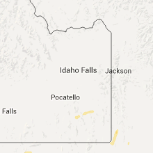
Idaho
| Local Time | Report Details |
|---|---|
| 9:33 PM MDT | Quarter sized hail reported near Bancroft, ID, 60.4 miles S of Idaho Falls, ID, reported via office facebook page. |
Connect with Interactive Hail Maps