

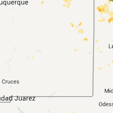
Hail Map for Saturday, June 16, 2012

Number of Impacted Households on 6/16/2012
0
Impacted by 1" or Larger Hail
0
Impacted by 1.75" or Larger Hail
0
Impacted by 2.5" or Larger Hail
Square Miles of Populated Area Impacted on 6/16/2012
0
Impacted by 1" or Larger Hail
0
Impacted by 1.75" or Larger Hail
0
Impacted by 2.5" or Larger Hail


Cities Most Affected by Hail Storms of 6/16/2012
| Hail Size | Demographics of Zip Codes Affected | ||||||
|---|---|---|---|---|---|---|---|
| City | Count | Average | Largest | Pop Density | House Value | Income | Age |
| Chillicothe, MO | 2 | 1.75 | 1.75 | 47 | $67k | $33.0k | 40.7 |
| Lucerne, MO | 1 | 1.75 | 1.75 | 3 | $15k | $32.2k | 46.0 |
| Unionville, MO | 1 | 1.75 | 1.75 | 15 | $49k | $24.5k | 44.7 |
| Crown Point, IN | 1 | 1.75 | 1.75 | 701 | $140k | $59.5k | 39.3 |
Hail and Wind Damage Spotted on 6/16/2012
Filter by Report Type:Hail ReportsWind Reports
States Impacted
Illinois, Ohio, Missouri, New Mexico, Iowa, Colorado, Indiana, Michigan, Kentucky, Oklahoma, Arizona, Wisconsin, TexasIllinois
| Local Time | Report Details |
|---|---|
| 7:30 AM CDT | 3 foot diameter tree down in stark county IL, 30.8 miles NNW of Peoria, IL |
| 12:15 PM CDT | Several trees blown down. a school lost part of its roof. report from wfo chicago storm spotte in champaign county IL, 57.6 miles NNE of Mattoon, IL |
| 5:05 PM CDT | Several minutes of pea sized hail also reporte in vermilion county IL, 75.3 miles NE of Mattoon, IL |
| 6:30 PM CDT | Reports of trees and power lines dow in warren county IL, 57.7 miles ENE of Kahoka, MO |
| 6:35 PM CDT | Reports of trees and power lines down. corrected locatio in warren county IL, 57.2 miles WNW of Peoria, IL |
| 6:40 PM CDT | Multiple trees and power lines dow in knox county IL, 43.3 miles W of Peoria, IL |
| 6:40 PM CDT | Multiple trees and power lines dow in knox county IL, 45.2 miles WNW of Peoria, IL |
| 6:43 PM CDT | Ping Pong Ball sized hail reported near Galesburg, IL, 44.4 miles WNW of Peoria, IL |
| 6:45 PM CDT | Several small tree limbs down on roa in knox county IL, 47.3 miles WNW of Peoria, IL |
| 6:48 PM CDT | Several machine sheds and wooden structures...2 metal and 1 concrete grain bin heavily damaged. 2 power poles snapped. damage extended from 3 miles southwest to 3 miles in hancock county IL, 36.1 miles ESE of Kahoka, MO |
| 7:01 PM CDT | Corn stalks flattened. time estiamted from rada in mcdonough county IL, 52.7 miles E of Kahoka, MO |
| 7:08 PM CDT | Quarter sized hail reported near Altona, IL, 42.1 miles NW of Peoria, IL |
| 7:10 PM CDT | Limbs down throughout town with damage to a vehicle due to flying plywood...also trees down blocking the road in perry and pleasant hill in pike county IL, 73.9 miles SE of Kahoka, MO |
| 7:15 PM CDT | Storm damage reported in pike county IL, 73.9 miles SE of Kahoka, MO |
| 7:20 PM CDT | 1 foot diameter branch down at river rd. also street flooding in kankakee county IL, 54 miles SSW of Chicago, IL |
| 7:30 PM CDT | 3 foot diameter tree down in stark county IL, 30.8 miles NNW of Peoria, IL |
| 7:33 PM CDT | Ping Pong Ball sized hail reported near Gilson, IL, 35 miles WNW of Peoria, IL |
| 7:45 PM CDT | Branches across roads. street floodin in will county IL, 50.3 miles SSW of Chicago, IL |
| 8:10 PM CDT | 4-6 inch limbs at market st area in kankakee county IL, 50 miles S of Chicago, IL |
| 8:31 PM CDT | Storm damage reported in tazewell county IL, 12.3 miles SSE of Peoria, IL |
Ohio
| Local Time | Report Details |
|---|---|
| 2:41 PM EDT | Large limbs down. via social media. time estimate in auglaize county OH, 52.5 miles SE of Fort Wayne, IN |
| 3:06 PM EDT | Tree downed...house siding damaged...chimney knocked over...chicken coop damage in greene county OH, 46.9 miles WSW of Columbus, OH |
| 3:38 PM EDT | Tree downed...house siding damaged...chimney knocked over...chicken coop damage in greene county OH, 46.4 miles SW of Columbus, OH |
Missouri
| Local Time | Report Details |
|---|---|
| 1:49 PM CDT | Storm damage reported in nodaway county MO, 84.8 miles SE of Omaha, NE |
| 1:59 PM CDT | Trees reported down along state highway ab...time unknown in nodaway county MO, 84.8 miles SE of Omaha, NE |
| 3:05 PM CDT | Ping Pong Ball sized hail reported near Lucerne, MO, 79.8 miles SSE of Des Moines, IA |
| 3:15 PM CDT | Golf Ball sized hail reported near Lucerne, MO, 80.3 miles SSE of Des Moines, IA, quarter to golf ball sized hail |
| 3:34 PM CDT | Golf Ball sized hail reported near Unionville, MO, 72.9 miles W of Kahoka, MO, fire dept reports golf ball size hail 5.5 miles west of unionville on rt u/iowa line. fire chief reported seeing some rotation lasted 2-3 minutes and dissipated. also r |
| 3:57 PM CDT | Quarter sized hail reported near Chillicothe, MO, 72.8 miles NE of Kansas City, MO, quarter size hail and 50 mph winds. |
| 4:01 PM CDT | Golf Ball sized hail reported near Chillicothe, MO, 74.5 miles NE of Kansas City, MO |
| 4:01 PM CDT | Golf Ball sized hail reported near Chillicothe, MO, 72.5 miles NE of Kansas City, MO, corrected location to 2 nw of chillicothe. |
| 4:01 PM CDT | Delyaed report. several 4 to 6 inch tree limbs down near the northern city limit in livingston county MO, 73.7 miles NE of Kansas City, MO |
| 4:57 PM CDT | Large tree down across noland rd in fayett in howard county MO, 23.5 miles NW of Columbia, MO |
| 7:21 PM CDT | West central columbia on braemore rd...24 to 30 inch diameter tree fell onto a house. retractable awning snapped in half. 30 ft tall tree onto roof of hous in boone county MO, 0.3 miles SE of Columbia, MO |
| 10:32 PM CDT | Public reports trees and power lines down on highway 133 west of dixo in pulaski county MO, 41 miles NW of Salem, MO |
| 10:50 PM CDT | Trees down in crocker on highway 13 in pulaski county MO, 45.1 miles WNW of Salem, MO |
| 10:50 PM CDT | Power lines blown dow in benton county MO, 75.3 miles N of Springfield, MO |
| 12:20 AM CDT | Quarter sized hail reported near Osceola, MO, 63.5 miles NW of Springfield, MO |
New Mexico
| Local Time | Report Details |
|---|---|
| 12:56 PM MDT | Quarter sized hail reported near Ruidoso Downs, NM, 62.4 miles W of Roswell, NM |
| 6:47 PM MDT | Storm damage reported in quay county NM, 20.8 miles NE of Tucumcari, NM |
| 6:47 PM MDT | Storm damage reported in quay county NM, 20.8 miles NE of Tucumcari, NM |
| 7:05 PM MDT | Power has been out since around 650 or 7 pm md in quay county NM, 41.2 miles NE of Tucumcari, NM |
| 7:05 PM MDT | Power has been out since around 650 or 7 pm md in quay county NM, 41.2 miles NE of Tucumcari, NM |
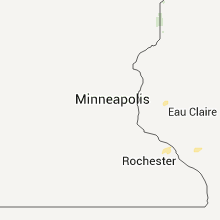
Iowa
| Local Time | Report Details |
|---|---|
| 2:35 PM CDT | Quarter sized hail reported near Mt Ayr, IA, 68.9 miles SSW of Des Moines, IA, trained spotter reports mostly pea to nickel sized hail with some quarters mixed in. time estimated. |
| 2:35 PM CDT | Quarter sized hail reported near Mt Ayr, IA, 68.3 miles SSW of Des Moines, IA, trained spotter reported mostly pea to nickel sized hail with a few quarters. time estimated. |
| 2:42 PM CDT | Quarter sized hail reported near Mt Pleasant, IA, 32.9 miles NNE of Kahoka, MO, dime and quarter sized hail lasting for about 15 minutes. he82 |
| 3:11 PM CDT | Several 3 to 4 inch branches down across the yar in decatur county IA, 69 miles SSW of Des Moines, IA |
| 4:00 PM CDT | Quarter sized hail reported near Bloomfield, IA, 48.8 miles WNW of Kahoka, MO, trained spotter reports quarter sized hail. time estimated. |
| 4:20 PM CDT | Numerous 6 inch and larger tree limbs down. heavy rai in wapello county IA, 52.5 miles NW of Kahoka, MO |
| 4:28 PM CDT | 3 inch or larger tree branches dow in wapello county IA, 55.3 miles NW of Kahoka, MO |
| 4:30 PM CDT | Medium sized tree downed along with numerous other branches. minor street flooding reported as wel in wapello county IA, 54.5 miles NW of Kahoka, MO |
| 4:32 PM CDT | Measured by idot rwis site near ottumwa along highway 63 in wapello county IA, 55.3 miles NW of Kahoka, MO |
| 4:34 PM CDT | Correction to previous entered lsr with knot to mph conversion error in wapello county IA, 61.1 miles NW of Kahoka, MO |
| 4:36 PM CDT | Reports of several trees down in tow in jefferson county IA, 45.8 miles NNW of Kahoka, MO |
| 4:41 PM CDT | Phone lines and tree branches down in the cit in jefferson county IA, 42.7 miles NNW of Kahoka, MO |
| 4:44 PM CDT | Larger than one foot diameter trees down. light pole dow in wapello county IA, 55.3 miles NW of Kahoka, MO |
| 4:45 PM CDT | Numerous 4 to 6 inch diameter tree branches down. estimated 65 mph wind in wapello county IA, 53.5 miles NNW of Kahoka, MO |
| 5:00 PM CDT | High winds and trees reported down in richlan in keokuk county IA, 55.1 miles NNW of Kahoka, MO |
| 5:08 PM CDT | Several 3 inch diameter tree limbs down in jefferson county IA, 51.4 miles NNW of Kahoka, MO |
| 5:10 PM CDT | Tree fell into house. time approximat in van buren county IA, 30.9 miles N of Kahoka, MO |
| 5:14 PM CDT | Machine shed with a south facing door lost roof as well as the in van buren county IA, 16.4 miles NNW of Kahoka, MO |
| 5:18 PM CDT | 6 inch diamter tree limb broken off of a pair tree. time of event correcte in van buren county IA, 15.9 miles NNW of Kahoka, MO |
| 5:26 PM CDT | Ck6 in van buren county IA, 15.3 miles NNW of Kahoka, MO |
| 5:30 PM CDT | 4 inch tree down and flattened corn. he108 in henry county IA, 47.4 miles NNE of Kahoka, MO |
| 5:56 PM CDT | 6 inch diamter tree limb broken off of a pair tre in van buren county IA, 15.9 miles NNW of Kahoka, MO |
| 5:56 PM CDT | 6 limb broken off of a pair tree. time estiamted by rada in van buren county IA, 16.5 miles NNW of Kahoka, MO |
| 6:05 PM CDT | Top half of 14 inch diameter tree blown onto street blocking 3 lanes of traffic at 1110 spring street. time estimate in des moines county IA, 41.4 miles NE of Kahoka, MO |
| 6:10 PM CDT | Delayed report - time estimated - a house just west of the burlington airport was damaged when half of a tree fell upon the house in des moines county IA, 41.4 miles NE of Kahoka, MO |
| 6:35 PM CDT | Reports of trees and power lines dow in jackson county IA, 41.4 miles E of Cedar Rapids, IA |
Colorado
| Local Time | Report Details |
|---|---|
| 1:51 PM MDT | Quarter sized hail reported near Cotopaxi, CO, 50.1 miles W of Pueblo, CO |
| 2:05 PM MDT | Ping Pong Ball sized hail reported near Cotopaxi, CO, 50.1 miles W of Pueblo, CO |
| 3:49 PM MDT | Quarter sized hail reported near Colorado City, CO, 25.8 miles SSW of Pueblo, CO |
Indiana
| Local Time | Report Details |
|---|---|
| 4:15 PM EDT | Scattered reports of tree and tree limbs across the city...including at wolf and sr 23. several tents were picked up at local festival. time estimated by rada in st. joseph county IN, 66.8 miles ESE of Chicago, IL |
| 3:40 PM CDT | Quarter sized hail reported near Crown Point, IN, 34 miles SSE of Chicago, IL |
| 4:43 PM EDT | Tree and large branches dow in fulton county IN, 67.5 miles W of Fort Wayne, IN |
| 3:44 PM CDT | Golf Ball sized hail reported near Crown Point, IN, 35 miles SSE of Chicago, IL, measured at crown point police dept |
| 3:45 PM CDT | Quarter sized hail reported near Merrillville, IN, 32.6 miles SSE of Chicago, IL, hail lasted from 345-350 pm |
| 3:45 PM CDT | Quarter sized hail reported near Crown Point, IN, 35.4 miles SSE of Chicago, IL |
| 4:45 PM EDT | Trees and branches down - blocking roadwa in fulton county IN, 60.1 miles W of Fort Wayne, IN |
| 4:46 PM EDT | Trees and large branches down on hom in fulton county IN, 59.6 miles W of Fort Wayne, IN |
| 4:46 PM EDT | Trees down - blocking road in fulton county IN, 61.2 miles W of Fort Wayne, IN |
| 4:47 PM EDT | Tree and branches down in fulton county IN, 58 miles W of Fort Wayne, IN |
| 4:47 PM EDT | Tree down and large branches blocking roa in fulton county IN, 58 miles W of Fort Wayne, IN |
| 4:48 PM EDT | Tree and branches down. street blocked in fulton county IN, 57.5 miles W of Fort Wayne, IN |
| 5:30 PM EDT | Report from town of rob roy. tree limbs approx 1 inch in diameter blown down. power outage delayed repor in fountain county IN, 66.5 miles WNW of Indianapolis, IN |
| 6:28 PM EDT | Broadcast media relayed a report of an outdoor storage building that was thrown into a neighbors yard in henryvill in clark county IN, 37.5 miles N of Louisville, KY |
| 6:30 PM EDT | Large tree limb down in clark county IN, 37.4 miles N of Louisville, KY |
| 6:40 PM EDT | Storm damage reported in clark county IN, 36 miles N of Louisville, KY |
| 7:00 PM EDT | Local media reported a large trees was blown down by strong winds across county road 68...blocking traffi in de kalb county IN, 16.9 miles NNE of Fort Wayne, IN |
| 7:32 PM EDT | Few trees down in tow in jay county IN, 50.1 miles S of Fort Wayne, IN |
| 9:05 PM CDT | Trees and powerlines down. time estimated based on rada in porter county IN, 46.5 miles SSE of Chicago, IL |
Michigan
| Local Time | Report Details |
|---|---|
| 4:55 PM EDT | Tree down on 126th ave south of saugatuck. health unknown. report relayed by woodt in allegan county MI, 35.3 miles SW of Grand Rapids, MI |
| 4:55 PM EDT | Tree damage. healthy 2 foot diameter branch and 18 inch diameter trunk snapped off. weather station anemometer registered 98 mph wind. no structural damage noted. high in allegan county MI, 28 miles SW of Grand Rapids, MI |
| 4:55 PM EDT | Tree damage. healthy 2 foot diameter branch and 18 inch diameter trunk snapped off. weather station anemometer registered 98 mph wind. no structural diameter noted. hig in allegan county MI, 28 miles SW of Grand Rapids, MI |
| 5:03 PM EDT | Wind gust at holland aso in allegan county MI, 26.8 miles SW of Grand Rapids, MI |
| 5:09 PM EDT | Multiple healthy 6 inch to 12 inch diameter trees down near zeelan in ottawa county MI, 18.8 miles WSW of Grand Rapids, MI |
| 5:20 PM EDT | Large healthy tree branch 15 inches in diameter down on a house. numerous other branches down in are in ottawa county MI, 8.5 miles WSW of Grand Rapids, MI |
| 5:30 PM EDT | Power lines down in kent cit in kent county MI, 18 miles NNW of Grand Rapids, MI |
| 5:30 PM EDT | Two trees came down near walker city hall. report relayed by woodt in kent county MI, 5.5 miles WNW of Grand Rapids, MI |
| 5:30 PM EDT | The top of a four foot diameter tree down near seventh street and covell. the top of a three foot diameter tree down near seventh street and oakhurst. both trees appear in kent county MI, 2.6 miles WNW of Grand Rapids, MI |
| 5:38 PM EDT | A large tree came down and power lines are down as wel in kent county MI, 5.5 miles WNW of Grand Rapids, MI |
| 5:40 PM EDT | At least two trees down in the westgate area of comstock park and a couple trees down at the maranantha church campground area in comstock park. time approximat in kent county MI, 5.1 miles N of Grand Rapids, MI |
| 5:40 PM EDT | Tree came down in north park and took down some wires with it. report courtesy of woodt in kent county MI, 4.4 miles N of Grand Rapids, MI |
| 5:57 PM EDT | A couple trees are down in the area. unknown health/siz in montcalm county MI, 28.5 miles NNE of Grand Rapids, MI |
Kentucky
| Local Time | Report Details |
|---|---|
| 5:06 PM EDT | Quarter sized hail reported near Flemingsburg, KY, 57.9 miles SE of Cincinnati, OH, 1 mile south of orangeburg hail covering the ground. hail lasted approximately 1/2 hour. |
Oklahoma
| Local Time | Report Details |
|---|---|
| 4:21 PM CDT | Quarter sized hail reported near Cache, OK, 45.4 miles N of Wichita Falls, TX |
Arizona
| Local Time | Report Details |
|---|---|
| 3:42 PM MST | Spotter reports tree limbs down. 0.75 mile west of twin peaks exi in pima county AZ, 17.5 miles NW of Tucson, AZ |
Wisconsin
| Local Time | Report Details |
|---|---|
| 6:53 PM CDT | Several trees and powerlines down in the cit in trempealeau county WI, 38.6 miles N of La Crosse, WI |
| 8:40 PM CDT | Tree down on north side of la cross in la crosse county WI, 2.2 miles NNE of La Crosse, WI |
| 8:40 PM CDT | Branches and powerlines down at pettibone park. also a road sign blown into highwa in la crosse county WI, 1.2 miles N of La Crosse, WI |
Texas
| Local Time | Report Details |
|---|---|
| 7:56 PM CDT | Storm damage reported in taylor county TX, 7.2 miles WSW of Abilene, TX |
| 8:30 PM CDT | Utility pole down at the corner of county road 254 and farm to market 613 in taylor county TX, 16.3 miles SSW of Abilene, TX |
| 9:13 PM CDT | Storm damage reported in hartley county TX, 69.6 miles NW of Amarillo, TX |
| 9:21 PM CDT | 4 to 6 inch tree limbs blown down with gust front ahead of thunderstorms on north side of dalhart in hartley county TX, 70.3 miles NNW of Amarillo, TX |
| 9:23 PM CDT | Storm damage reported in hartley county TX, 69.6 miles NW of Amarillo, TX |
| 9:50 PM CDT | A tractor trailer was knocked off its jacks and blown down. power lines blown down as well. pea size hail accompanied the stor in randall county TX, 14.7 miles WSW of Amarillo, TX |
| 10:10 PM CDT | Storm damage reported in potter county TX, 10 miles W of Amarillo, TX |
| 10:12 PM CDT | Storm damage reported in randall county TX, 7.7 miles SSW of Amarillo, TX |
| 10:13 PM CDT | Storm damage reported in randall county TX, 2.7 miles SSE of Amarillo, TX |
| 10:14 PM CDT | Storm damage reported in potter county TX, 12.3 miles W of Amarillo, TX |
| 10:50 PM CDT | 3 inch tree limb was blown down from a pine tre in armstrong county TX, 27.7 miles ESE of Amarillo, TX |
Connect with Interactive Hail Maps