

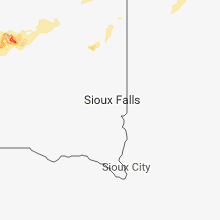
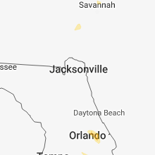
Hail Map for Saturday, June 16, 2018

Number of Impacted Households on 6/16/2018
0
Impacted by 1" or Larger Hail
0
Impacted by 1.75" or Larger Hail
0
Impacted by 2.5" or Larger Hail
Square Miles of Populated Area Impacted on 6/16/2018
0
Impacted by 1" or Larger Hail
0
Impacted by 1.75" or Larger Hail
0
Impacted by 2.5" or Larger Hail


Cities Most Affected by Hail Storms of 6/16/2018
| Hail Size | Demographics of Zip Codes Affected | ||||||
|---|---|---|---|---|---|---|---|
| City | Count | Average | Largest | Pop Density | House Value | Income | Age |
| Miller, SD | 1 | 1.75 | 1.75 | 4 | $50k | $31.0k | 48.7 |
| Poynette, WI | 1 | 1.75 | 1.75 | 76 | $129k | $50.8k | 43.0 |
Hail and Wind Damage Spotted on 6/16/2018
Filter by Report Type:Hail ReportsWind Reports
States Impacted
North Dakota, South Dakota, Minnesota, Michigan, Georgia, New Mexico, North Carolina, Florida, Ohio, South Carolina, Wisconsin, Colorado, Texas, Missouri, Tennessee, Alabama, MontanaNorth Dakota
| Local Time | Report Details |
|---|---|
| 7:35 AM CDT | Nearby gwinner airport measured 49 knot wind gus in sargent county ND, 61 miles SW of Fargo, ND |
| 7:50 AM CDT | Storm damage reported in ransom county ND, 54.2 miles SW of Fargo, ND |
| 9:48 AM MDT | Quarter sized hail reported near Mott, ND, 88.7 miles WSW of Bismarck, ND, hail of all different sizes with the largest around the size of a quarter. lasted 5 minutes. time estimated from radar. |
South Dakota
| Local Time | Report Details |
|---|---|
| 7:05 AM MDT | Half Dollar sized hail reported near Timber Lake, SD, 87.4 miles NNW of Pierre, SD, dime to nickel hail covered the ground. half dollar was the largest size. |
| 7:30 AM MDT | Quarter sized hail reported near Isabel, SD, 88.6 miles NW of Pierre, SD, quarter size hail was reported around 8:30. hail lasted for 15 minutes. hail covered the ground. estimated 2 to 2.5 inches of rainfall. |
| 7:31 AM MDT | Quarter sized hail reported near Isabel, SD, 91.5 miles NW of Pierre, SD |
| 8:05 AM MDT | Half Dollar sized hail reported near Timber Lake, SD, 87.4 miles NNW of Pierre, SD, dime to nickel hail covered the ground. half dollar was the largest size. |
| 6:59 PM CDT | Storm damage reported in hyde county SD, 38.7 miles ENE of Pierre, SD |
| 7:20 PM CDT | Quarter sized hail reported near Holabird, SD, 41.8 miles ENE of Pierre, SD |
| 8:05 PM CDT | Golf Ball sized hail reported near Miller, SD, 62 miles SSW of Aberdeen, SD |
| 8:52 PM CDT | Estimated 70 mph winds in and near hitchcoc in beadle county SD, 57.4 miles S of Aberdeen, SD |
| 9:18 PM CDT | Storm damage reported in spink county SD, 49.9 miles S of Aberdeen, SD |
Minnesota
| Local Time | Report Details |
|---|---|
| 8:40 AM CDT | Storm damage reported in wilkin county MN, 40.9 miles SE of Fargo, ND |
Michigan
| Local Time | Report Details |
|---|---|
| 10:40 AM CDT | Tree reported down across the railroad line parallel to u.s. 41 near the intersection with county road 366 in talbo in menominee county MI, 71.7 miles NNE of Green Bay, WI |
Georgia
| Local Time | Report Details |
|---|---|
| 1:24 PM EDT | Report of powerlines down at the intersection of horton rd. and arborview dr. in lumpkin county... g in lumpkin county GA, 58.6 miles NNE of Atlanta, GA |
| 2:37 PM EDT | Tree reported down in roadway on walton way. time estimated by rada in richmond county GA, 0.7 miles SSW of Augusta, GA |
| 3:58 PM EDT | Warning point reported tree down on poor robin road. time estimated based on rada in screven county GA, 49.2 miles NNW of Savannah, GA |
| 4:38 PM EDT | Warning point reported tree down on hiltonia-perkins road. time estimated based on rada in screven county GA, 45.6 miles SSE of Augusta, GA |
| 4:55 PM EDT | Quarter sized hail reported near Acworth, GA, 28 miles NW of Atlanta, GA, quarter-sized hail reported by public on social media in acworth. |
| 5:10 PM EDT | Tree reported down on power lines at the intersection of dabbs bridge rd and crystal mountain r in paulding county GA, 31.6 miles NW of Atlanta, GA |
| 5:32 PM EDT | Power lines reported down at the intersection of bryant ln and bridal pat in cobb county GA, 20.2 miles NNW of Atlanta, GA |
| 6:19 PM EDT | Burke county dispatch reported trees down on quaker road past taylor road. also reports of heavy rai in burke county GA, 25.6 miles SSW of Augusta, GA |
| 6:26 PM EDT | Tree reported down at mack dobbs rd at stilesboro rd n in cobb county GA, 22.9 miles NW of Atlanta, GA |
| 9:11 PM EDT | Tree and power lines reported down at the intersection of wesley chapel rd and hwy 4 in putnam county GA, 66.3 miles ESE of Atlanta, GA |
| 9:40 PM EDT | Tree reported down at the intersection of hwy 83 and alexander r in jasper county GA, 51.1 miles SE of Atlanta, GA |
| 9:44 PM EDT | Tree reported down at the intersection of hwy 83 and alexander r in jasper county GA, 51.1 miles SE of Atlanta, GA |
| 10:00 PM EDT | Tree reported down at the 1700 block of 7 island r in jasper county GA, 46.1 miles SE of Atlanta, GA |
New Mexico
| Local Time | Report Details |
|---|---|
| 11:55 AM MDT | Storm damage reported in eddy county NM, 37.7 miles S of Roswell, NM |
| 12:05 PM MDT | Measured at personal weather station. location is 20th st and hermosa av in eddy county NM, 38.5 miles S of Roswell, NM |
| 12:32 PM MDT | Storm damage reported in eddy county NM, 73.6 miles SSE of Roswell, NM |
North Carolina
| Local Time | Report Details |
|---|---|
| 2:45 PM EDT | Damage to power lines on rosman hw in transylvania county NC, 25.6 miles NNW of Greenville, SC |
| 2:45 PM EDT | Tree debris in roadway at rosman hwy and parkway rd in transylvania county NC, 25.3 miles NNW of Greenville, SC |
| 2:50 PM EDT | Tree down on hwy 64 near camp chosatonga in transylvania county NC, 26.2 miles NNW of Greenville, SC |
Florida
| Local Time | Report Details |
|---|---|
| 3:14 PM EDT | Public citizen reported wind gusts blowing lighter lawn furniture around with some small branches at spring par in clay county FL, 23.6 miles S of Jacksonville, FL |
| 4:30 PM EDT | Report relayed via twitter of strong winds causing damage to large limbs and a tree down off celery ave in east sanford in seminole county FL, 19.9 miles NNE of Orlando, FL |
Ohio
| Local Time | Report Details |
|---|---|
| 3:23 PM EDT | Quarter sized hail reported near Brookville, OH, 50.8 miles N of Cincinnati, OH |
| 3:25 PM EDT | Half Dollar sized hail reported near Brookville, OH, 50.8 miles N of Cincinnati, OH |
| 3:40 PM EDT | One tree down. time estimated from rada in montgomery county OH, 50.9 miles NNE of Cincinnati, OH |
| 3:44 PM EDT | One tree dow in montgomery county OH, 52.2 miles NNE of Cincinnati, OH |
| 3:56 PM EDT | One tree down. time estimated from rada in montgomery county OH, 54.3 miles N of Cincinnati, OH |
| 4:07 PM EDT | Numerous trees down. a few windows blown out. roof damage to a few home in licking county OH, 16.6 miles E of Columbus, OH |
| 4:15 PM EDT | Numerous trees downed. time estimated from rada in fairfield county OH, 17.3 miles E of Columbus, OH |
| 4:39 PM EDT | Numerous trees down in baltimore... oh. time estimated from rada in fairfield county OH, 22.8 miles ESE of Columbus, OH |
| 4:53 PM EDT | Tree down on a ca in montgomery county OH, 36 miles N of Cincinnati, OH |
| 4:55 PM EDT | Trees downe in warren county OH, 34.4 miles NNE of Cincinnati, OH |
| 7:59 PM EDT | Large limbs downe in fairfield county OH, 12.7 miles ESE of Columbus, OH |
| 8:24 PM EDT | Multiple trees down on flint ridge rd. time estimated from rada in licking county OH, 39.5 miles E of Columbus, OH |
| 8:30 PM EDT | Trees down on lake rd north of 22. time estimated from rada in fairfield county OH, 30.8 miles ESE of Columbus, OH |
| 8:30 PM EDT | 4 inch branches down on pleasantville rd. time estimated from rada in fairfield county OH, 28 miles SE of Columbus, OH |
| 8:36 PM EDT | Trees downed. time estimated from rada in logan county OH, 58.6 miles NW of Columbus, OH |
| 8:44 PM EDT | Multiple trees down across rush creek township. time estimated from rada in fairfield county OH, 35.9 miles ESE of Columbus, OH |
| 8:46 PM EDT | Trees down on oh-37 near perry county line. time estimated from rada in fairfield county OH, 37.6 miles ESE of Columbus, OH |
South Carolina
| Local Time | Report Details |
|---|---|
| 3:40 PM EDT | Schp reported a tree down at highway 183 and cedar rock rd in pickens county SC, 4.4 miles NW of Greenville, SC |
| 4:00 PM EDT | Trees and power lines down along ireland roa in pickens county SC, 4.3 miles NW of Greenville, SC |
| 4:05 PM EDT | Tree down across the roadway at ballentine street and brushy roa in pickens county SC, 1.4 miles ESE of Greenville, SC |
| 4:05 PM EDT | Trees and power lines down at store road and cedar rock church roa in pickens county SC, 2.6 miles WNW of Greenville, SC |
| 4:25 PM EDT | One tree down in roadway near intersection of highway 25 and roe ford roa in greenville county SC, 11.4 miles NE of Greenville, SC |
| 4:40 PM EDT | Nws employee reported numerous large limbs down in the half mile lake subdivision. time estimated from rada in greenville county SC, 13.4 miles ENE of Greenville, SC |
| 5:39 PM EDT | Several trees and powerines down in the city of union. two of the trees fell on residence in union county SC, 56.3 miles E of Greenville, SC |
| 7:20 PM EDT | Schp reported tree in roadway on broad river road at miller eleazer road. time estimated by rada in richland county SC, 61.8 miles NE of Augusta, GA |
| 7:25 PM EDT | Schp reported tree in roadway at springhill fire station. time estimated by rada in richland county SC, 62.4 miles NE of Augusta, GA |
| 7:37 PM EDT | Schp reported tree in roadway on old lexington highway at wessinger roa in lexington county SC, 57.6 miles NE of Augusta, GA |
| 8:45 PM EDT | A tree limb in the road at intersection of bush river road and hopewell church road. also hail of unknown size was reported at the intersection of bush river road and m in laurens county SC, 52.1 miles SE of Greenville, SC |
| 9:04 PM EDT | Schp reported a tree down at milton rd and bush river rd in laurens county SC, 52.1 miles SE of Greenville, SC |
Wisconsin
| Local Time | Report Details |
|---|---|
| 3:35 PM CDT | Tree blown down over a drivewa in sauk county WI, 32.4 miles NNW of Madison, WI |
| 4:00 PM CDT | Trees down around portag in columbia county WI, 32.4 miles N of Madison, WI |
| 4:40 PM CDT | Half Dollar sized hail reported near Waupaca, WI, 59.3 miles WSW of Green Bay, WI, report via social media. time approximate. |
| 4:50 PM CDT | Trees and power lines down south of portag in columbia county WI, 26.7 miles N of Madison, WI |
| 4:55 PM CDT | Three trees down approx. 1 to 2 miles west of wautoma. time estimated by rada in waushara county WI, 68.3 miles N of Madison, WI |
| 5:15 PM CDT | Pictures from social media show trees down across traut road with power lines down too. time estimated from rada in columbia county WI, 24.4 miles N of Madison, WI |
| 5:35 PM CDT | Quarter sized hail reported near Portage, WI, 32.5 miles N of Madison, WI |
| 5:54 PM CDT | Half Dollar sized hail reported near Portage, WI, 28 miles NNW of Madison, WI, mping report. |
| 5:56 PM CDT | Golf Ball sized hail reported near Poynette, WI, 26.4 miles N of Madison, WI |
| 6:11 PM CDT | Quarter sized hail reported near Poynette, WI, 26.9 miles N of Madison, WI, mping report. |
| 6:42 PM CDT | Quarter sized hail reported near Poynette, WI, 26.9 miles N of Madison, WI, reported in dekorra. |
| 6:50 PM CDT | Quarter sized hail reported near Saint Germain, WI, 19 miles N of Rhinelander, WI |
| 6:55 PM CDT | Half Dollar sized hail reported near Saint Germain, WI, 18.5 miles NNW of Rhinelander, WI, courtesy of ares spotter n9nbc |
| 7:00 PM CDT | Half Dollar sized hail reported near Saint Germain, WI, 18.1 miles N of Rhinelander, WI, report from intersection of hwy 70 and county hwy o. courtesy of ares spotter kc9kak. |
| 10:24 PM CDT | Quarter sized hail reported near La Pointe, WI, 62.7 miles E of Duluth, MN, reported via mping. |
Colorado
| Local Time | Report Details |
|---|---|
| 2:44 PM MDT | Half Dollar sized hail reported near Grover, CO, 48.7 miles ESE of Laramie, WY |
Texas
| Local Time | Report Details |
|---|---|
| 4:10 PM CDT | Measured by the texas tech university west texas mesonet in hockley county TX, 29.4 miles W of Lubbock, TX |
| 4:57 PM CDT | Measured by the texas tech university west texas mesonet in lamb county TX, 57.7 miles NW of Lubbock, TX |
| 6:05 PM CDT | Measured by the texas tech university west texas mesonet in hockley county TX, 29.4 miles W of Lubbock, TX |
| 6:19 PM CDT | Storm damage reported in pecos county TX, 57.2 miles SW of Odessa, TX |
| 6:19 PM CDT | Multiple structures were damaged by strong wind gusts. the damage included two metal roofs... brick and metal from a home... and downed power line in hockley county TX, 29.1 miles W of Lubbock, TX |
Missouri
| Local Time | Report Details |
|---|---|
| 4:34 PM CDT | Tree damage with limbs down and power outages reporte in new madrid county MO, 32.2 miles SSW of Cape Girardeau, MO |
Tennessee
| Local Time | Report Details |
|---|---|
| 5:12 PM CDT | Limbs were blown down by estimated 40 mph wind gust in providence. pea size hail also occurre in wilson county TN, 16.1 miles E of Nashville, TN |
| 5:15 PM CDT | A large tree was blown down... blocking westbound lanes on belinda parkwa in wilson county TN, 16.7 miles E of Nashville, TN |
| 7:15 PM CDT | Several trees down blocking woodmont blvd between estes road and hillsboro pike in davidson county TN, 4.6 miles SSW of Nashville, TN |
| 7:18 PM CDT | Quarter sized hail reported near Nashville, TN, 2.9 miles SSW of Nashville, TN, spotter report 1 inch hail. |
Alabama
| Local Time | Report Details |
|---|---|
| 5:36 PM CDT | Quarter sized hail reported near Gadsden, AL, 51 miles NE of Birmingham, AL, most of the hail was pea to dime size but a few pieces were nickel to quarter size. the hail lasted almost 10 minutes. |
| 5:45 PM CDT | Trees and power lines were blown down near wain dr. and highway 7 in etowah county AL, 53.6 miles NE of Birmingham, AL |
| 8:10 PM CDT | A few trees were blown down near arle in winston county AL, 45.5 miles NNW of Birmingham, AL |
| 8:40 PM CDT | A few trees blown down near ashridg in winston county AL, 40.4 miles SSE of Florence, AL |
| 8:42 PM CDT | A few trees were blown down northwest of double spring in winston county AL, 44.3 miles SSE of Florence, AL |
Montana
| Local Time | Report Details |
|---|---|
| 5:17 PM MDT | Quarter sized hail reported near Joliet, MT, 32.7 miles SW of Billings, MT |
Connect with Interactive Hail Maps