

Hail Map for Saturday, June 17, 2017

Number of Impacted Households on 6/17/2017
0
Impacted by 1" or Larger Hail
0
Impacted by 1.75" or Larger Hail
0
Impacted by 2.5" or Larger Hail
Square Miles of Populated Area Impacted on 6/17/2017
0
Impacted by 1" or Larger Hail
0
Impacted by 1.75" or Larger Hail
0
Impacted by 2.5" or Larger Hail


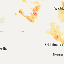


Cities Most Affected by Hail Storms of 6/17/2017
| Hail Size | Demographics of Zip Codes Affected | ||||||
|---|---|---|---|---|---|---|---|
| City | Count | Average | Largest | Pop Density | House Value | Income | Age |
| Centerville, IA | 4 | 2.44 | 3.00 | 59 | $48k | $28.5k | 43.1 |
| Kahoka, MO | 4 | 2.06 | 2.75 | 24 | $57k | $28.6k | 41.4 |
| Greensburg, KS | 3 | 2.42 | 2.75 | 5 | $49k | $30.8k | 45.4 |
| Cimarron, KS | 2 | 2.00 | 2.00 | 2 | $80k | $40.2k | 34.1 |
| Muscatine, IA | 2 | 1.88 | 2.00 | 177 | $84k | $41.0k | 38.1 |
| Memphis, MO | 2 | 1.88 | 2.00 | 16 | $50k | $30.1k | 40.0 |
| White City, KS | 2 | 1.75 | 1.75 | 5 | $40k | $36.2k | 41.6 |
| Belpre, KS | 1 | 2.75 | 2.75 | 2 | $13k | $25.4k | 45.8 |
| Montezuma, KS | 1 | 2.00 | 2.00 | 3 | $75k | $40.1k | 35.3 |
| Junction City, KS | 1 | 1.75 | 1.75 | 128 | $67k | $31.2k | 29.3 |
| Chapman, KS | 1 | 1.75 | 1.75 | 14 | $68k | $42.3k | 40.1 |
| Fowler, KS | 1 | 1.75 | 1.75 | 1 | $41k | $36.1k | 41.5 |
| Promise City, IA | 1 | 1.75 | 1.75 | 6 | $31k | $22.9k | 47.9 |
| Mount Sterling, IL | 1 | 1.75 | 1.75 | 20 | $50k | $34.0k | 35.8 |
Hail and Wind Damage Spotted on 6/17/2017
Filter by Report Type:Hail ReportsWind Reports
States Impacted
Kansas, Oklahoma, Florida, Minnesota, Georgia, Michigan, Illinois, Iowa, Missouri, IndianaKansas
| Local Time | Report Details |
|---|---|
| 7:05 AM CDT | Minor damage reported to the porch of one home. also numerous trees down in the riverton area. given extent of damage... winds are estimated at 70 mp in cherokee county KS, 58.6 miles SE of Chanute, KS |
| 7:12 AM CDT | Twelve inch limb down at 8th and woodland in pittsbur in crawford county KS, 44.6 miles ESE of Chanute, KS |
| 7:29 AM CDT | Large eight inch limbs down and tops blown out of a few tree in cherokee county KS, 54.9 miles SE of Chanute, KS |
| 5:40 PM CDT | Quarter sized hail reported near Macksville, KS, 59.6 miles SSE of Hays, KS |
| 6:08 PM CDT | Quarter sized hail reported near Belpre, KS, 65 miles S of Hays, KS |
| 6:30 PM CDT | Golf Ball sized hail reported near Chapman, KS, 33 miles SW of Manhattan, KS |
| 6:43 PM CDT | Golf Ball sized hail reported near Junction City, KS, 27.5 miles SW of Manhattan, KS |
| 6:45 PM CDT | Baseball sized hail reported near Belpre, KS, 64.8 miles S of Hays, KS, from picture on twitter. time estimated from radar. |
| 6:58 PM CDT | Golf Ball sized hail reported near White City, KS, 27.7 miles SSW of Manhattan, KS |
| 7:15 PM CDT | Golf Ball sized hail reported near White City, KS, 24.6 miles SSW of Manhattan, KS, social media. |
| 7:22 PM CDT | Quarter sized hail reported near Belpre, KS, 71.5 miles S of Hays, KS |
| 7:27 PM CDT | Half Dollar sized hail reported near Topeka, KS, 48 miles E of Manhattan, KS |
| 7:30 PM CDT | Quarter sized hail reported near Topeka, KS, 46.9 miles E of Manhattan, KS |
| 7:43 PM CDT | Half Dollar sized hail reported near Haviland, KS, 72.1 miles SSE of Hays, KS |
| 7:45 PM CDT | Quarter sized hail reported near Ozawkie, KS, 48.8 miles W of Kansas City, MO |
| 7:55 PM CDT | Ping Pong Ball sized hail reported near Cimarron, KS, 33.1 miles SE of Garden City, KS |
| 7:55 PM CDT | Hen Egg sized hail reported near Montezuma, KS, 34.4 miles SE of Garden City, KS, hail damage to a house window and a cracked windshield. |
| 7:55 PM CDT | Hen Egg sized hail reported near Cimarron, KS, 36.5 miles SE of Garden City, KS, hail damage to 7 windows and 4 vehicles as well as metal siding. |
| 8:03 PM CDT | Quarter sized hail reported near Kinsley, KS, 78.1 miles S of Hays, KS |
| 8:03 PM CDT | Hen Egg sized hail reported near Cimarron, KS, 34.2 miles ESE of Garden City, KS, delayed report...via social media photo. |
| 8:10 PM CDT | Quarter sized hail reported near Hoyt, KS, 46 miles E of Manhattan, KS |
| 8:11 PM CDT | Quarter sized hail reported near Meriden, KS, 52.3 miles E of Manhattan, KS, dime to quarter sized hail... heavy rain. |
| 8:11 PM CDT | Storm damage reported in osage county KS, 48.9 miles SE of Manhattan, KS |
| 8:12 PM CDT | Storm damage reported in osage county KS, 46.3 miles ESE of Manhattan, KS |
| 8:19 PM CDT | Quarter sized hail reported near Meriden, KS, 52.2 miles E of Manhattan, KS |
| 8:29 PM CDT | Ping Pong Ball sized hail reported near Ensign, KS, 46.4 miles SE of Garden City, KS |
| 8:35 PM CDT | Storm damage reported in kiowa county KS, 81.2 miles N of Woodward, OK |
| 8:35 PM CDT | Golf Ball sized hail reported near Greensburg, KS, 81.3 miles N of Woodward, OK |
| 8:36 PM CDT | Quarter sized hail reported near Florence, KS, 48.2 miles NNE of Wichita, KS |
| 8:37 PM CDT | Baseball sized hail reported near Greensburg, KS, 81.2 miles N of Woodward, OK |
| 8:40 PM CDT | Golf Ball sized hail reported near Fowler, KS, 52.4 miles SE of Garden City, KS |
| 8:43 PM CDT | Baseball sized hail reported near Greensburg, KS, 81.3 miles N of Woodward, OK, golf ball to baseball size hail. |
| 8:43 PM CDT | Ping Pong Ball sized hail reported near Fowler, KS, 54.3 miles SE of Garden City, KS, quarter to ping pong hail. |
| 8:50 PM CDT | Storm damage reported in leavenworth county KS, 23 miles NW of Kansas City, MO |
| 8:51 PM CDT | Powerlines down in lansing with a blown transforme in leavenworth county KS, 19.8 miles WNW of Kansas City, MO |
| 8:52 PM CDT | County road 1 and cantrell r in leavenworth county KS, 27.7 miles W of Kansas City, MO |
| 8:53 PM CDT | Measured at k-10 and kill creek rd. reported via e in johnson county KS, 22.6 miles WSW of Kansas City, MO |
| 8:55 PM CDT | Ping Pong Ball sized hail reported near Greensburg, KS, 74.7 miles N of Woodward, OK |
| 8:57 PM CDT | Medium size limbs dow in wyandotte county KS, 17 miles W of Kansas City, MO |
| 9:00 PM CDT | 2-3 inch diameter black walnut branches snappe in johnson county KS, 8.9 miles SW of Kansas City, MO |
| 9:12 PM CDT | Em relayed report. measured at 75th st. & i-3 in johnson county KS, 10 miles SW of Kansas City, MO |
| 9:12 PM CDT | Quarter sized hail reported near Mullinville, KS, 71.6 miles N of Woodward, OK |
| 9:15 PM CDT | Quarter sized hail reported near Larned, KS, 44.4 miles SSE of Hays, KS |
| 9:15 PM CDT | 3-5 in diameter limbs snappe in wyandotte county KS, 3.3 miles SSW of Kansas City, MO |
| 9:16 PM CDT | Storm damage reported in butler county KS, 45.2 miles ENE of Wichita, KS |
| 9:23 PM CDT | Storm damage reported in coffey county KS, 45.2 miles NNW of Chanute, KS |
| 9:35 PM CDT | Tree blown dow in coffey county KS, 41 miles NNW of Chanute, KS |
| 9:38 PM CDT | Storm damage reported in greenwood county KS, 53.1 miles ENE of Wichita, KS |
| 9:39 PM CDT | Storm damage reported in butler county KS, 26.6 miles ENE of Wichita, KS |
| 9:50 PM CDT | Trained spotter estimates 65 to 75 mp in greenwood county KS, 43.4 miles WNW of Chanute, KS |
| 9:58 PM CDT | Winds sustained 45 to 55 mph...estimated maximum gust to 80 mp in greenwood county KS, 43.4 miles WNW of Chanute, KS |
| 10:11 PM CDT | High winds at 70 mph reported along highway 54 and highway 105. along with marble size hai in woodson county KS, 28.5 miles WNW of Chanute, KS |
| 10:13 PM CDT | Ping Pong Ball sized hail reported near Wichita, KS, 6.1 miles SE of Wichita, KS, pea to ping-pong ball size hail. |
| 10:16 PM CDT | Storm damage reported in butler county KS, 14.8 miles ESE of Wichita, KS |
| 10:28 PM CDT | Quarter sized hail reported near Rose Hill, KS, 13.9 miles SE of Wichita, KS, 1 inch hail at the rose hill fire station. |
| 10:47 PM CDT | Storm damage reported in neosho county KS, 2.3 miles WSW of Chanute, KS |
| 10:50 PM CDT | Delayed report...occurred about 15 minutes ag in elk county KS, 55.1 miles ESE of Wichita, KS |
| 10:57 PM CDT | Law enforcement reports 55 to 65 mph winds in the riverdale are in sumner county KS, 22.8 miles S of Wichita, KS |
| 11:27 PM CDT | Storm damage reported in montgomery county KS, 40.9 miles SSW of Chanute, KS |
Oklahoma
| Local Time | Report Details |
|---|---|
| 7:36 AM CDT | Tree down in afton. time estimated by rada in ottawa county OK, 68.6 miles ENE of Tulsa, OK |
| 8:50 AM CDT | Measured 1 mile east of tahlequah airport. power out in parts of tahlequa in cherokee county OK, 48.7 miles NW of Fort Smith, AR |
| 9:01 AM CDT | Power lines across hwy 100 in webbers falls. time estimated by rada in muskogee county OK, 40.9 miles WNW of Fort Smith, AR |
| 9:07 AM CDT | Several large trees down east of fort gibson. time estimated by rada in muskogee county OK, 50.6 miles ESE of Tulsa, OK |
| 9:30 AM CDT | Flag pole blown down in gore. time estimated by rada in sequoyah county OK, 40.7 miles WNW of Fort Smith, AR |
| 9:36 AM CDT | Power pole down on ray fine blvd in gore. time estimated by rada in sequoyah county OK, 40.7 miles WNW of Fort Smith, AR |
| 9:47 AM CDT | Electric lines down on hwy 64 bridge near webbers falls. time estimated by rada in muskogee county OK, 40.9 miles WNW of Fort Smith, AR |
| 9:55 AM CDT | Storm damage reported in muskogee county OK, 40.9 miles WNW of Fort Smith, AR |
| 10:50 AM CDT | Storm damage reported in latimer county OK, 58.5 miles NE of Atoka, OK |
| 11:00 AM CDT | Quarter sized hail reported near Red Oak, OK, 54.6 miles SW of Fort Smith, AR |
| 11:20 AM CDT | Barn damaged/destroyed in panola. tree damage all across latimer count in latimer county OK, 54.6 miles SW of Fort Smith, AR |
| 10:35 PM CDT | Storm damage reported in woods county OK, 43.7 miles NNE of Woodward, OK |
| 3:45 AM CDT | 65 mph wind gust at the marshall mesone in logan county OK, 43.5 miles N of Oklahoma City, OK |
| 3:50 AM CDT | Storm damage reported in logan county OK, 43.5 miles N of Oklahoma City, OK |
Florida
| Local Time | Report Details |
|---|---|
| 2:38 PM EDT | Central dispatch reported a tree down at 152 lake alcyon in hamilton county FL, 62.7 miles ENE of Tallahassee, FL |
| 2:56 PM EDT | Central dispatch reported a tree down at nw 23rd blvd and nw 26 lan in hamilton county FL, 63.8 miles E of Tallahassee, FL |
| 3:51 PM EDT | Central dispatch reported a tree down at highway 129 and interstate 7 in hamilton county FL, 72.9 miles S of Douglas, GA |
| 3:54 PM EDT | Central dispatch reported a tree down on 5th avenue sw in jaspe in hamilton county FL, 68.2 miles S of Douglas, GA |
| 6:40 PM EDT | Tree knocked down onto power lines. repairs are currently underwa in nassau county FL, 22.4 miles W of Jacksonville, FL |
Minnesota
| Local Time | Report Details |
|---|---|
| 2:15 PM CDT | Half Dollar sized hail reported near Hawley, MN, 21.1 miles E of Fargo, ND, video submitted to nws facebook of hail up to 1.25 inch size at silver lake. |
Georgia
| Local Time | Report Details |
|---|---|
| 4:00 PM EDT | A tree was reported down near the intersection of scooter rue road and hillbridge roa in laurens county GA, 67.6 miles N of Douglas, GA |
| 4:36 PM EDT | A tree was reported down on southern pines roa in laurens county GA, 70.6 miles N of Douglas, GA |
| 6:30 PM EDT | Wind gust of 42 knots measured with anemomete in camden county GA, 33.7 miles N of Jacksonville, FL |
| 6:30 PM EDT | Wind gust of 42 knots measured with anemomete in camden county GA, 33.7 miles N of Jacksonville, FL |
| 6:54 PM EDT | Reports of multiple trees down on us 280 near bacontown roa in bryan county GA, 36 miles W of Savannah, GA |
Michigan
| Local Time | Report Details |
|---|---|
| 4:40 PM EDT | Four trees down in elba township. time estimated from rada in gratiot county MI, 37.3 miles WNW of Flint, MI |
| 4:51 PM EDT | Report of multiple trees down in saginaw county MI, 32 miles WNW of Flint, MI |
| 4:57 PM EDT | Reports of multiple trees and wires down in saginaw county MI, 28.5 miles WNW of Flint, MI |
| 6:34 PM EDT | Reports of trees down on morse and sanilac rd in sanilac county MI, 51.6 miles ENE of Flint, MI |
| 6:34 PM EDT | Reports of trees down on morse and sanilac rd in sanilac county MI, 51.6 miles ENE of Flint, MI |
Illinois
| Local Time | Report Details |
|---|---|
| 4:33 PM CDT | Event occurred in the 6000 block of stillman rd. commercial seed building approximately 40 feet by 80 feet damaged. propane tank moved. two mobile home parks have damag in ogle county IL, 68 miles S of Madison, WI |
| 6:20 PM CDT | Emergency manager for mercer county reported limbs and whole trees down near reynolds along with the roof off of a hog confine that was wrapped around a tree. a neighbo in rock island county IL, 68.5 miles SE of Cedar Rapids, IA |
| 6:51 PM CDT | Quarter sized hail reported near Rock Falls, IL, 74.6 miles N of Peoria, IL, passed along by nws chicago |
| 7:37 PM CDT | Numerous trees dow in stark county IL, 28.5 miles NNW of Peoria, IL |
| 7:48 PM CDT | Numerous trees blown dow in stark county IL, 27.1 miles NNW of Peoria, IL |
| 7:58 PM CDT | Numerous trees blown down across count in stark county IL, 30.9 miles NNW of Peoria, IL |
| 8:18 PM CDT | Trees and powerlines downed in mchenry county IL, 46.8 miles NW of Chicago, IL |
| 8:20 PM CDT | Quarter sized hail reported near Warsaw, IL, 21 miles ESE of Kahoka, MO |
| 8:20 PM CDT | Storm damage reported in woodford county IL, 8.2 miles NE of Peoria, IL |
| 8:24 PM CDT | Trees and powerlines downed in mchenry county IL, 44.7 miles NW of Chicago, IL |
| 8:26 PM CDT | Trees down on powerlines in mchenry county IL, 41.7 miles WNW of Chicago, IL |
| 8:29 PM CDT | Report relayed via twitter. location near border of algonquin and lake in the hill in mchenry county IL, 39.3 miles WNW of Chicago, IL |
| 8:30 PM CDT | Near 1820 n and 1700 e...detached garage leveled...dairy barn damaged...18-20 inch trees blown dow in woodford county IL, 21.7 miles ENE of Peoria, IL |
| 9:15 PM CDT | Storm damage reported in mclean county IL, 42.6 miles E of Peoria, IL |
| 9:30 PM CDT | County sheriff office reported several damage calls. no specifics at this time as to the caus in brown county IL, 59.2 miles ESE of Kahoka, MO |
| 9:45 PM CDT | Golf Ball sized hail reported near Mount Sterling, IL, 59.9 miles ESE of Kahoka, MO, ema director reported golf ball size hail and some trees and power lines down south of mount sterling. |
| 9:45 PM CDT | Ema director reported golf ball size hail and some trees and power lines down south of mount sterlin in brown county IL, 59.9 miles ESE of Kahoka, MO |
| 9:50 PM CDT | A few trees down in town...including one blocking the road at church and 8th. many small branches down. time estimate in ford county IL, 65.4 miles ESE of Peoria, IL |
| 9:55 PM CDT | Ema director reported minor roof damage in la grang in brown county IL, 70.7 miles ESE of Kahoka, MO |
| 10:00 PM CDT | Quarter sized hail reported near Beardstown, IL, 64.7 miles SW of Peoria, IL |
| 10:00 PM CDT | Illinois route 67 on the morgan/cass county line...small trees blown dow in morgan county IL, 74.4 miles SW of Peoria, IL |
| 10:15 PM CDT | 1500 block of lowrey...tree blown down...far east side of tow in champaign county IL, 57.6 miles NNE of Mattoon, IL |
| 10:30 PM CDT | Storm damage reported in vermilion county IL, 64.8 miles NNE of Mattoon, IL |
| 10:35 PM CDT | Numerous power poles down throughout count in mclean county IL, 42.6 miles E of Peoria, IL |
| 10:52 PM CDT | Powerlines blown dow in sangamon county IL, 65.6 miles S of Peoria, IL |
| 1:02 AM CDT | Trees and power lines reported dow in montgomery county IL, 58.6 miles NE of Saint Louis, MO |
| 1:40 AM CDT | Multiple tree limbs down... some up to 12 inches in diamete in monroe county IL, 11.7 miles S of Saint Louis, MO |
| 1:45 AM CDT | 6 to 8 inch tree limbs blown dow in st. clair county IL, 9.2 miles E of Saint Louis, MO |
| 1:55 AM CDT | Tree branches of unknown size down on hwy 159 between redbud and hecker illinoi in monroe county IL, 26.3 miles SSE of Saint Louis, MO |
| 2:03 AM CDT | Tree branches of unknown size down on hwy 159 between redbud and hecker illinoi in monroe county IL, 26.3 miles SSE of Saint Louis, MO |
| 3:16 AM CDT | Media report relayed via wfo paducah in clay county IL, 56.3 miles S of Mattoon, IL |
| 3:19 AM CDT | At flora airport in clay county IL, 56.2 miles S of Mattoon, IL |
| 3:19 AM CDT | A few trees down. one fell through the roof of a house. relayed via wfo st loui in clay county IL, 56.3 miles S of Mattoon, IL |
| 3:19 AM CDT | Power poles and lines down on highway 45 south of flor in clay county IL, 56.9 miles S of Mattoon, IL |
Iowa
| Local Time | Report Details |
|---|---|
| 5:30 PM CDT | Quarter sized hail reported near Nichols, IA, 39.1 miles SSE of Cedar Rapids, IA |
| 5:30 PM CDT | Storm damage reported in muscatine county IA, 39.1 miles SSE of Cedar Rapids, IA |
| 5:45 PM CDT | Quarter sized hail reported near Muscatine, IA, 48.2 miles SE of Cedar Rapids, IA, quarter size hail accompanied by estimated 50 mph winds. power went out at time of report. |
| 5:45 PM CDT | Tree damage noted on the east side of muscatine. winds estimated above 60 mp in muscatine county IA, 50.1 miles SE of Cedar Rapids, IA |
| 5:45 PM CDT | Half Dollar sized hail reported near Muscatine, IA, 49.5 miles SE of Cedar Rapids, IA |
| 5:46 PM CDT | Golf Ball sized hail reported near Promise City, IA, 60.9 miles SSE of Des Moines, IA |
| 5:49 PM CDT | Half Dollar sized hail reported near Muscatine, IA, 48.1 miles SE of Cedar Rapids, IA |
| 5:50 PM CDT | Half Dollar sized hail reported near Muscatine, IA, 49.7 miles SE of Cedar Rapids, IA, lasted for 3 minutes. |
| 5:52 PM CDT | Quarter sized hail reported near Muscatine, IA, 48.9 miles SE of Cedar Rapids, IA, pea to nickel |
| 5:52 PM CDT | Golf Ball sized hail reported near Muscatine, IA, 49.1 miles SE of Cedar Rapids, IA |
| 5:55 PM CDT | Hen Egg sized hail reported near Muscatine, IA, 50.1 miles SE of Cedar Rapids, IA, most hail was golf ball size... but there were a few up to 2 inches in diameter. |
| 5:57 PM CDT | Half Dollar sized hail reported near Muscatine, IA, 49.5 miles SE of Cedar Rapids, IA, some a little larger than half dollar.hail lasted for 7 minutes. |
| 5:57 PM CDT | Small tree blown over. estimated wind speed of 65 mp in muscatine county IA, 49.5 miles SE of Cedar Rapids, IA |
| 6:05 PM CDT | Half Dollar sized hail reported near Centerville, IA, 64.4 miles WNW of Kahoka, MO |
| 6:05 PM CDT | Tea Cup sized hail reported near Centerville, IA, 64 miles WNW of Kahoka, MO, trained spotter reports jagged very large hail that potentially is 3-4 inches in diameter. numerous leaves and small branches down due to the hail. |
| 6:06 PM CDT | Tea Cup sized hail reported near Centerville, IA, 63.5 miles WNW of Kahoka, MO |
| 6:08 PM CDT | Hen Egg sized hail reported near Centerville, IA, 64.2 miles WNW of Kahoka, MO |
| 6:08 PM CDT | Golf Ball sized hail reported near Centerville, IA, 64.9 miles WNW of Kahoka, MO |
Missouri
| Local Time | Report Details |
|---|---|
| 7:19 PM CDT | Storm damage reported in scotland county MO, 23.9 miles W of Kahoka, MO |
| 7:20 PM CDT | Half Dollar sized hail reported near Memphis, MO, 23.9 miles W of Kahoka, MO |
| 7:20 PM CDT | Hen Egg sized hail reported near Memphis, MO, 23.9 miles W of Kahoka, MO, via the internet |
| 7:21 PM CDT | Golf Ball sized hail reported near Memphis, MO, 23.9 miles W of Kahoka, MO |
| 7:43 PM CDT | Several tree branches and power lines down in town...time estimated from rada in clark county MO, 8.7 miles WNW of Kahoka, MO |
| 7:43 PM CDT | Golf Ball sized hail reported near Kahoka, MO, 2.8 miles S of Kahoka, MO, accompanied by 50 mph winds. no damage noted. |
| 7:49 PM CDT | Baseball sized hail reported near Kahoka, MO, 5.6 miles S of Kahoka, MO, wind driven hail up to baseball sized. numerous windshields destroyed. |
| 7:54 PM CDT | Hen Egg sized hail reported near Kahoka, MO, 4.9 miles S of Kahoka, MO, time estimated from radar. |
| 7:57 PM CDT | Golf Ball sized hail reported near Kahoka, MO, 4.9 miles S of Kahoka, MO, hail may have been larger than golf balls. broke out windows in multiple cars. |
| 7:57 PM CDT | 20 inch tree limbs broken from intense wind in clark county MO, 4.9 miles S of Kahoka, MO |
| 8:20 PM CDT | Storm damage reported in clark county MO, 11.9 miles WSW of Kahoka, MO |
| 8:20 PM CDT | 12 inch tree fell down on three cars. no injuries reporte in jackson county MO, 6.6 miles ESE of Kansas City, MO |
| 8:59 PM CDT | South of platte city on highway in platte county MO, 20 miles NNW of Kansas City, MO |
| 9:05 PM CDT | Tree snapped in half in clay county MO, 12.2 miles N of Kansas City, MO |
| 9:07 PM CDT | Went on for 3-4 minute in platte county MO, 5.5 miles NNW of Kansas City, MO |
| 9:10 PM CDT | 10 inch diameter tree fell on a car. no one was injure in clay county MO, 6.9 miles NNE of Kansas City, MO |
| 9:15 PM CDT | Em reports gladstone has several streets blocked due to damage... good portion of the city without power... public works deploying crews for debris remova in clay county MO, 6.8 miles N of Kansas City, MO |
| 9:15 PM CDT | Trees down at 61st st. and howard av in clay county MO, 6.9 miles NNE of Kansas City, MO |
| 9:15 PM CDT | Numerous trees down between walmart and 66th terrace... approximately 6-8 inches in diamete in clay county MO, 8.3 miles NNE of Kansas City, MO |
| 9:17 PM CDT | 50 to 60 mph est. winds at 72nd st. and antioch r in clay county MO, 8.6 miles NNE of Kansas City, MO |
| 9:18 PM CDT | At 93rd st. and north oak trfw in clay county MO, 10.8 miles N of Kansas City, MO |
| 9:19 PM CDT | Broadcast media reports damage to the boulevardia event in the west bottom in jackson county MO, 2.5 miles SSW of Kansas City, MO |
| 9:25 PM CDT | Storm damage reported in clay county MO, 6.7 miles N of Kansas City, MO |
| 9:25 PM CDT | Storm damage reported in clay county MO, 11.1 miles NNE of Kansas City, MO |
| 9:25 PM CDT | Power flashes observed. bp gas station sign across from kauffman stadium dow in jackson county MO, 6.6 miles ESE of Kansas City, MO |
| 9:25 PM CDT | Spotter saw transformers blow. reported at worlds of fu in clay county MO, 7.3 miles NE of Kansas City, MO |
| 9:25 PM CDT | Storm damage reported in jackson county MO, 10.2 miles SSE of Kansas City, MO |
| 9:29 PM CDT | Multiple trees down. 61st st. and antioch r in clay county MO, 6.9 miles NNE of Kansas City, MO |
| 9:29 PM CDT | 4 to 6 inch trees blocking the road at 44th st. and phelps r in jackson county MO, 10.8 miles ESE of Kansas City, MO |
| 9:30 PM CDT | 3-4 inch diameter limbs down from healthy tree in jackson county MO, 9.5 miles ESE of Kansas City, MO |
| 9:30 PM CDT | 4 in diameter trees snappe in clay county MO, 6.7 miles N of Kansas City, MO |
| 9:34 PM CDT | 50-60mph winds at u.s. hwy 40 and phelps r in jackson county MO, 10.8 miles ESE of Kansas City, MO |
| 9:40 PM CDT | Storm damage reported in jackson county MO, 17.9 miles ESE of Kansas City, MO |
| 9:43 PM CDT | Vehicle shaking. transformers blowing south of spotter's locatio in jackson county MO, 19 miles ESE of Kansas City, MO |
| 9:44 PM CDT | Reported at lee's summit rd. and u.s. hwy 4 in jackson county MO, 11.5 miles ESE of Kansas City, MO |
| 9:45 PM CDT | 8 inch diameter healthy tree branch snappe in jackson county MO, 19.9 miles SE of Kansas City, MO |
| 9:52 PM CDT | 6 in diameter tree limbs snappe in jackson county MO, 15.5 miles ESE of Kansas City, MO |
| 9:54 PM CDT | Trees and powerlines down in odessa. via twitte in lafayette county MO, 34.8 miles ESE of Kansas City, MO |
| 9:55 PM CDT | Storm damage reported in jackson county MO, 25.2 miles ESE of Kansas City, MO |
| 10:10 PM CDT | 10 inch diameter healthy maple tree snapped near the bas in clay county MO, 6.3 miles NNE of Kansas City, MO |
| 10:10 PM CDT | At i-70 and route 1 in lafayette county MO, 45.9 miles E of Kansas City, MO |
| 10:20 PM CDT | Saw 3 power flashes with this gus in lafayette county MO, 58.9 miles E of Kansas City, MO |
| 10:42 PM CDT | Quarter sized hail reported near Meadville, MO, 74 miles NW of Columbia, MO, em relayed report of nickel to quarter size hail near fountain grove. |
| 10:47 PM CDT | Numerous large trees down throughout the city. utility poles snapped in half. no known structural damage at this tim in howard county MO, 33.7 miles NW of Columbia, MO |
| 10:50 PM CDT | Powerlines down...large limbs and trees down in howard county MO, 33.7 miles NW of Columbia, MO |
| 11:01 PM CDT | Large tree down in cooper county MO, 39.9 miles WSW of Columbia, MO |
| 11:36 PM CDT | Storm spotter reported a peak wind gust of 76 mph on his weather statio in boone county MO, 11.6 miles SSE of Columbia, MO |
| 11:50 PM CDT | 911 office reported trees... powerlines... and some street light poles dow in callaway county MO, 21.9 miles ESE of Columbia, MO |
Indiana
| Local Time | Report Details |
|---|---|
| 12:23 AM EDT | Tree down and some downed limbs. funnel cloud also spotted but never touched dow in white county IN, 82.8 miles SSE of Chicago, IL |
| 1:46 AM EDT | Storm damage reported in grant county IN, 52.3 miles NNE of Indianapolis, IN |
Connect with Interactive Hail Maps