

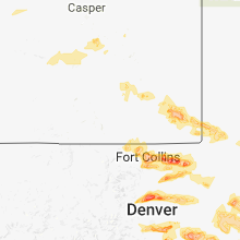
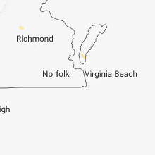
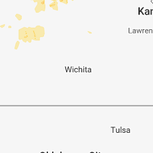
Hail Map for Tuesday, June 19, 2018

Number of Impacted Households on 6/19/2018
0
Impacted by 1" or Larger Hail
0
Impacted by 1.75" or Larger Hail
0
Impacted by 2.5" or Larger Hail
Square Miles of Populated Area Impacted on 6/19/2018
0
Impacted by 1" or Larger Hail
0
Impacted by 1.75" or Larger Hail
0
Impacted by 2.5" or Larger Hail


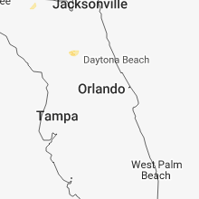

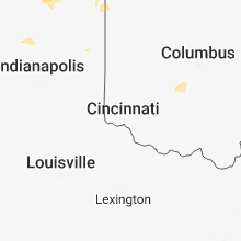


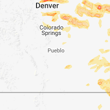


Cities Most Affected by Hail Storms of 6/19/2018
| Hail Size | Demographics of Zip Codes Affected | ||||||
|---|---|---|---|---|---|---|---|
| City | Count | Average | Largest | Pop Density | House Value | Income | Age |
| Oakley, KS | 4 | 2.69 | 3.00 | 5 | $57k | $32.4k | 45.3 |
| Aurora, CO | 4 | 2.44 | 2.75 | 2676 | $234k | $75.2k | 34.9 |
| Englewood, CO | 3 | 2.58 | 3.00 | 2959 | $261k | $73.3k | 38.0 |
| Elkhart, KS | 3 | 1.83 | 2.00 | 2 | $83k | $49.2k | 38.3 |
| Livermore, CO | 2 | 1.88 | 2.00 | 5 | $190k | $59.7k | 53.6 |
| Monument, CO | 2 | 1.88 | 2.00 | 691 | $270k | $87.9k | 42.8 |
| Denver, CO | 2 | 1.88 | 2.00 | 3868 | $111k | $25.8k | 36.1 |
| Franklin, NE | 2 | 1.88 | 2.00 | 11 | $36k | $28.6k | 48.5 |
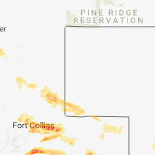
| Fort Collins, CO | 2 | 1.75 | 1.75 | 2070 | $142k | $31.8k | 23.1 |
| Littleton, CO | 2 | 1.75 | 1.75 | 3412 | $188k | $49.4k | 42.1 |
| Colorado Springs, CO | 1 | 3.00 | 3.00 | 153 | $245k | $76.1k | 45.0 |
| Yuma, CO | 1 | 2.75 | 2.75 | 7 | $84k | $32.3k | 37.1 |
| Florissant, CO | 1 | 2.75 | 2.75 | 28 | $140k | $45.6k | 50.3 |
| Orleans, NE | 1 | 2.75 | 2.75 | 3 | $29k | $27.6k | 47.2 |
| Bushnell, NE | 1 | 2.50 | 2.50 | 0 | $20k | $28.1k | 53.3 |
| Scott City, KS | 1 | 2.00 | 2.00 | 6 | $72k | $40.5k | 41.5 |
| Hudson, CO | 1 | 2.00 | 2.00 | 26 | $145k | $50.4k | 39.6 |
| Ramah, CO | 1 | 2.00 | 2.00 | 3 | $91k | $39.0k | 44.6 |
| Nunn, CO | 1 | 1.75 | 1.75 | 4 | $104k | $41.1k | 41.3 |
| Agate, CO | 1 | 1.75 | 1.75 | 1 | $131k | $40.7k | 50.9 |
| Greeley, CO | 1 | 1.75 | 1.75 | 1454 | $147k | $49.0k | 36.2 |
| Flagler, CO | 1 | 1.75 | 1.75 | 1 | $74k | $30.4k | 46.7 |
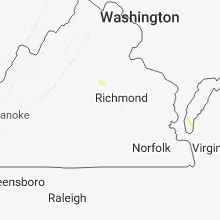
Hail and Wind Damage Spotted on 6/19/2018
Filter by Report Type:Hail ReportsWind Reports
States Impacted
Kansas, Louisiana, Colorado, Virginia, District of Columbia, Maryland, Wyoming, Illinois, Indiana, Nebraska, West Virginia, Ohio, Montana, Missouri, OklahomaKansas
| Local Time | Report Details |
|---|---|
| 10:35 AM CDT | Quarter sized hail reported near Oakley, KS, 43 miles SSE of Colby, KS, corrects previous hail report from 5 wnw the monument rocks. |
| 4:00 PM CDT | Quarter sized hail reported near Richfield, KS, 78 miles SW of Garden City, KS |
| 4:00 PM CDT | Quarter sized hail reported near Scott City, KS, 34.6 miles N of Garden City, KS |
| 4:33 PM CDT | Quarter sized hail reported near Scott City, KS, 34.6 miles N of Garden City, KS |
| 4:33 PM CDT | Quarter sized hail reported near Lakin, KS, 32.1 miles WSW of Garden City, KS |
| 4:35 PM CDT | Hen Egg sized hail reported near Scott City, KS, 35.9 miles N of Garden City, KS, image from social media & matched with radar. several stones at least 2 inches. 5 miles west of scott city at hwy 96 and grant road. |
| 4:35 PM CDT | Quarter sized hail reported near Oakley, KS, 43 miles SSE of Colby, KS, corrects previous hail report from 5 wnw the monument rocks. |
| 4:49 PM CDT | Quarter sized hail reported near Utica, KS, 42.2 miles W of Hays, KS |
| 5:28 PM CDT | Baseball sized hail reported near Oakley, KS, 20.9 miles SSE of Colby, KS, numerous two inch stones observed... with largest hail baseball size. |
| 5:28 PM CDT | Tea Cup sized hail reported near Oakley, KS, 21.2 miles SSE of Colby, KS, corrects previous hail report from oakley. followup at 5:40 pm mdt for earlier oakley hail reports from 4:28 pm mdt. police measured 3.25" hail with vehicle windows bro |
| 5:30 PM CDT | Hen Egg sized hail reported near Oakley, KS, 20.9 miles SSE of Colby, KS, report from twitter. hail lasted 5 minutes. |
| 5:47 PM CDT | Storm damage reported in trego county KS, 30.1 miles W of Hays, KS |
| 6:00 PM CDT | Quarter sized hail reported near Rolla, KS, 73 miles SW of Garden City, KS |
| 6:05 PM CDT | Public report of t-storm wind gus in morton county KS, 73 miles SW of Garden City, KS |
| 6:20 PM CDT | Golf Ball sized hail reported near Elkhart, KS, 77.3 miles SW of Garden City, KS |
| 6:34 PM CDT | Quarter sized hail reported near Rolla, KS, 71.8 miles SW of Garden City, KS |
| 6:40 PM CDT | Ping Pong Ball sized hail reported near Rolla, KS, 77.6 miles SW of Garden City, KS |
| 6:49 PM CDT | 50 to 60 mph wind gust in republic county KS, 76.1 miles SSE of Grand Island, NE |
| 7:03 PM CDT | Spotter estimated winds were at least 70 mph as storm passed. a few large cottonwood trees blown dow in cheyenne county KS, 51.9 miles SE of Yuma, CO |
| 7:04 PM CDT | Tea Cup sized hail reported near Oakley, KS, 21.2 miles SSE of Colby, KS, followup at 5:40 pm mdt for earlier oakley hail reports from 4:28 pm mdt. police measured 3.25" hail with vehicle windows broken... major hail dents and some trees stri |
| 7:12 PM CDT | Late report relayed from emergency manager. large tree uprooted and blocking road. time estimated from rada in cheyenne county KS, 47.9 miles WNW of Colby, KS |
| 7:13 PM CDT | Corrects previous tstm wnd gst report from saint franci in cheyenne county KS, 47.8 miles WNW of Colby, KS |
| 7:14 PM CDT | Storm damage reported in cheyenne county KS, 47.8 miles WNW of Colby, KS |
| 7:15 PM CDT | Restaurant owner had door torn off hinge in republic county KS, 78 miles NW of Manhattan, KS |
| 7:16 PM CDT | Quarter sized hail reported near Saint Francis, KS, 47.8 miles WNW of Colby, KS, quarter inch hail in st. francis measured by public via facebook. |
| 7:16 PM CDT | Measured at st francis airpor in cheyenne county KS, 48.2 miles WNW of Colby, KS |
| 7:20 PM CDT | Storm damage reported in cheyenne county KS, 41.6 miles WNW of Colby, KS |
| 7:20 PM CDT | Report from storm spotter on social medi in ellis county KS, 0.6 miles N of Hays, KS |
| 6:21 PM MDT | Storm damage reported in sherman county KS, 40.6 miles W of Colby, KS |
| 7:22 PM CDT | Half Dollar sized hail reported near Saint Francis, KS, 50.3 miles NW of Colby, KS, hail fell from 6:12 - 6:22 pm mdt. also received 0.80" of rain. |
| 7:26 PM CDT | 59mph kansas mesonet 2m wind speed repor in ellis county KS, 1.5 miles SSW of Hays, KS |
| 7:27 PM CDT | Half Dollar sized hail reported near Saint Francis, KS, 43.4 miles NW of Colby, KS, hailstone measured 1.50" x 0.75". windows broken on north side of house. |
| 6:29 PM MDT | Measured at goodland airpor in sherman county KS, 35.8 miles W of Colby, KS |
| 7:30 PM CDT | Several reports of damage including metal buildings damaged or destroyed... as well as numerous power poles downed around the hays are in ellis county KS, 0.9 miles NE of Hays, KS |
| 7:30 PM CDT | Storm damage reported in jewell county KS, 72.1 miles S of Grand Island, NE |
| 7:30 PM CDT | Report via social media of intermediate-size tree limbs and roof debris along with 60 mph wind gus in ellis county KS, 0.8 miles NNW of Hays, KS |
| 6:32 PM MDT | Mesonet sit in wallace county KS, 48.4 miles WSW of Colby, KS |
| 6:40 PM MDT | Off-duty nws employee reported a 60 mph thunderstorm wind gus in sherman county KS, 21.3 miles WNW of Colby, KS |
| 6:51 PM MDT | Mesonet sit in wallace county KS, 61.6 miles SW of Colby, KS |
| 7:55 PM CDT | Quarter sized hail reported near Rolla, KS, 71.8 miles SW of Garden City, KS |
| 7:06 PM MDT | Mesonet station e7715... 10 s sharon springs measured 65 mph wind in wallace county KS, 58.4 miles SW of Colby, KS |
| 7:15 PM MDT | Quarter sized hail reported near Syracuse, KS, 54.5 miles W of Garden City, KS |
| 8:16 PM CDT | Quarter sized hail reported near Elkhart, KS, 81.9 miles SW of Garden City, KS |
| 8:17 PM CDT | Half Dollar sized hail reported near Elkhart, KS, 77.3 miles SW of Garden City, KS |
| 7:26 PM MDT | Tribune awos measured thunderstorm wind gust of 66 mp in greeley county KS, 60.2 miles NW of Garden City, KS |
| 7:29 PM MDT | Storm damage reported in greeley county KS, 62 miles NW of Garden City, KS |
| 8:30 PM CDT | Hen Egg sized hail reported near Elkhart, KS, 77.3 miles SW of Garden City, KS |
| 8:33 PM CDT | Golf Ball sized hail reported near Elkhart, KS, 78.6 miles SW of Garden City, KS |
| 8:35 PM CDT | Quarter sized hail reported near Rolla, KS, 78.1 miles SSW of Garden City, KS, lots of quarter size hail on the ground. |
| 8:43 PM CDT | Tree dow in cloud county KS, 64.7 miles WNW of Manhattan, KS |
| 9:02 PM CDT | Storm damage reported in scott county KS, 35.2 miles N of Garden City, KS |
| 9:15 PM CDT | Large tree blown over at golf course in scott county KS, 36 miles N of Garden City, KS |
| 9:18 PM CDT | Storm damage reported in lane county KS, 49.3 miles NNE of Garden City, KS |
| 9:20 PM CDT | Mesonet station k5elw... 7 sw westfal in ellsworth county KS, 68.1 miles E of Hays, KS |
| 9:22 PM CDT | Estimated 65 to 70 with some tree branches dow in lincoln county KS, 73.3 miles E of Hays, KS |
| 9:30 PM CDT | Mesonet station k5elw... 7 sw westfal in ellsworth county KS, 68.1 miles E of Hays, KS |
| 9:35 PM CDT | From social media and phone call: estimated 60-65 mph wind gus in finney county KS, 1.3 miles E of Garden City, KS |
| 9:46 PM CDT | Storm damage reported in finney county KS, 8.3 miles ESE of Garden City, KS |
| 9:48 PM CDT | Electrical fire. power lines sparking after strong wind gust in finney county KS, 1.5 miles ENE of Garden City, KS |
| 9:55 PM CDT | Storm damage reported in stanton county KS, 53.7 miles WSW of Garden City, KS |
| 9:58 PM CDT | Garden city aso in finney county KS, 8.3 miles ESE of Garden City, KS |
| 10:00 PM CDT | Storm damage reported in cheyenne county KS, 47.8 miles WNW of Colby, KS |
| 10:00 PM CDT | Garden city aso in finney county KS, 8.3 miles ESE of Garden City, KS |
| 10:07 PM CDT | Storm damage reported in finney county KS, 8.3 miles ESE of Garden City, KS |
| 10:15 PM CDT | Ulysses aso in grant county KS, 36.8 miles SW of Garden City, KS |
| 10:15 PM CDT | Power lost to all of ulysses... ks due to wind strong gusts. power was regained at approximately 10:35pm. time matched with 60 mph wind gust reported at the airport (10 in grant county KS, 37.8 miles SW of Garden City, KS |
| 10:15 PM CDT | Thunderstorm wind gust caused power to go out in parts of cimarron. time matched to radar outflo in gray county KS, 30.6 miles ESE of Garden City, KS |
| 10:20 PM CDT | Two campers blown over at horsethief reservoi in hodgeman county KS, 43 miles E of Garden City, KS |
| 10:26 PM CDT | Storm damage reported in hodgeman county KS, 53.8 miles E of Garden City, KS |
| 10:47 PM CDT | Sixty to seventy mph wind and dime size hail was reporte in stanton county KS, 55.3 miles WSW of Garden City, KS |
| 10:51 PM CDT | Storm damage reported in ford county KS, 51.4 miles ESE of Garden City, KS |
| 11:04 PM CDT | Storm damage reported in pawnee county KS, 47.9 miles S of Hays, KS |
| 11:13 PM CDT | Storm damage reported in seward county KS, 64.3 miles S of Garden City, KS |
| 11:13 PM CDT | Larned lost power due to strong wind for about an hour. many 4 inch tree limbs are on the ground and one... healthy 7 inch tree limb is on the groun in pawnee county KS, 49.3 miles SSE of Hays, KS |
| 11:15 PM CDT | Storm damage reported in clark county KS, 59.7 miles SE of Garden City, KS |
| 11:42 PM CDT | Storm damage reported in barton county KS, 38.4 miles SE of Hays, KS |
Louisiana
| Local Time | Report Details |
|---|---|
| 1:00 PM CDT | Large tree limbs down near i-10 bridge on east side of sabine rive in calcasieu county LA, 4.2 miles NE of Beaumont, TX |
Colorado
| Local Time | Report Details |
|---|---|
| 12:18 PM MDT | Quarter sized hail reported near Longmont, CO, 27.6 miles NNW of Denver, CO |
| 12:40 PM MDT | Quarter sized hail reported near Longmont, CO, 28 miles NNW of Denver, CO |
| 12:43 PM MDT | Half Dollar sized hail reported near Longmont, CO, 28.3 miles NNW of Denver, CO |
| 12:47 PM MDT | Golf Ball sized hail reported near Livermore, CO, 25.8 miles SSE of Laramie, WY, broken house windows. |
| 12:50 PM MDT | Ping Pong Ball sized hail reported near Longmont, CO, 28 miles NNW of Denver, CO |
| 12:55 PM MDT | Hen Egg sized hail reported near Livermore, CO, 34.6 miles SSE of Laramie, WY |
| 12:55 PM MDT | Ping Pong Ball sized hail reported near Greeley, CO, 48 miles NNE of Denver, CO |
| 12:58 PM MDT | Ping Pong Ball sized hail reported near Longmont, CO, 26.3 miles N of Denver, CO |
| 1:00 PM MDT | Quarter sized hail reported near Greeley, CO, 48.8 miles NNE of Denver, CO |
| 1:00 PM MDT | Half Dollar sized hail reported near Longmont, CO, 26.3 miles N of Denver, CO |
| 1:01 PM MDT | Quarter sized hail reported near Denver, CO, 8 miles SW of Denver, CO |
| 1:01 PM MDT | Quarter sized hail reported near Denver, CO, 4.6 miles SSW of Denver, CO |
| 1:01 PM MDT | Half Dollar sized hail reported near Longmont, CO, 29 miles NNW of Denver, CO |
| 1:04 PM MDT | Golf Ball sized hail reported near Littleton, CO, 10.4 miles S of Denver, CO |
| 1:05 PM MDT | Golf Ball sized hail reported near Littleton, CO, 10.4 miles S of Denver, CO |
| 1:07 PM MDT | Quarter sized hail reported near Denver, CO, 7.9 miles SW of Denver, CO |
| 1:12 PM MDT | Golf Ball sized hail reported near Greeley, CO, 48.8 miles NNE of Denver, CO |
| 1:15 PM MDT | Quarter sized hail reported near Englewood, CO, 8.3 miles S of Denver, CO |
| 1:15 PM MDT | Hen Egg sized hail reported near Englewood, CO, 10.5 miles SSE of Denver, CO |
| 1:15 PM MDT | Quarter sized hail reported near Longmont, CO, 26.4 miles N of Denver, CO |
| 1:22 PM MDT | Quarter sized hail reported near Fort Lupton, CO, 26.7 miles NNE of Denver, CO |
| 1:25 PM MDT | Half Dollar sized hail reported near Aurora, CO, 13.6 miles SE of Denver, CO |
| 1:25 PM MDT | Tea Cup sized hail reported near Englewood, CO, 6.2 miles S of Denver, CO |
| 1:25 PM MDT | Golf Ball sized hail reported near Denver, CO, 6.8 miles ENE of Denver, CO |
| 1:30 PM MDT | Baseball sized hail reported near Englewood, CO, 9.1 miles SSE of Denver, CO |
| 1:30 PM MDT | Quarter sized hail reported near Gill, CO, 58.4 miles NNE of Denver, CO |
| 1:33 PM MDT | Hen Egg sized hail reported near Denver, CO, 8.8 miles SE of Denver, CO |
| 1:35 PM MDT | Quarter sized hail reported near Englewood, CO, 13 miles SE of Denver, CO |
| 1:39 PM MDT | Half Dollar sized hail reported near Aurora, CO, 11.2 miles ESE of Denver, CO |
| 1:40 PM MDT | Tennis Ball sized hail reported near Aurora, CO, 14 miles SE of Denver, CO, 1.75 to 2 inch hail. |
| 1:45 PM MDT | Hen Egg sized hail reported near Aurora, CO, 15.7 miles SE of Denver, CO |
| 1:46 PM MDT | Hen Egg sized hail reported near Hudson, CO, 31.2 miles NE of Denver, CO |
| 1:47 PM MDT | Quarter sized hail reported near Aurora, CO, 13.5 miles E of Denver, CO |
| 1:49 PM MDT | Half Dollar sized hail reported near Hudson, CO, 29.5 miles NE of Denver, CO |
| 2:00 PM MDT | Tennis Ball sized hail reported near Aurora, CO, 10.1 miles ESE of Denver, CO, aurora reservoir. |
| 2:00 PM MDT | Baseball sized hail reported near Florissant, CO, 63.6 miles SSW of Denver, CO |
| 2:06 PM MDT | Baseball sized hail reported near Aurora, CO, 17.5 miles ESE of Denver, CO |
| 2:22 PM MDT | Ping Pong Ball sized hail reported near Wellington, CO, 51.6 miles SE of Laramie, WY |
| 2:35 PM MDT | Ping Pong Ball sized hail reported near Fort Collins, CO, 47.6 miles SE of Laramie, WY, hail 2-3 inches deep... buck drive & cr-19. |
| 2:55 PM MDT | Ping Pong Ball sized hail reported near Pierce, CO, 63.3 miles SE of Laramie, WY |
| 3:02 PM MDT | Golf Ball sized hail reported near Nunn, CO, 58.3 miles SE of Laramie, WY |
| 3:18 PM MDT | Quarter sized hail reported near Parker, CO, 24.7 miles SE of Denver, CO |
| 3:30 PM MDT | Quarter sized hail reported near Aurora, CO, 19.1 miles SE of Denver, CO |
| 4:03 PM MDT | Quarter sized hail reported near Monument, CO, 44.6 miles S of Denver, CO |
| 4:05 PM MDT | Quarter sized hail reported near Fort Collins, CO, 57 miles N of Denver, CO |
| 4:08 PM MDT | Half Dollar sized hail reported near Flagler, CO, 46.1 miles SW of Yuma, CO |
| 4:10 PM MDT | Hen Egg sized hail reported near Monument, CO, 44.6 miles S of Denver, CO |
| 4:10 PM MDT | Quarter sized hail reported near Monument, CO, 46 miles S of Denver, CO, between 400 pm and 410 pm. |
| 4:12 PM MDT | Quarter sized hail reported near Fort Collins, CO, 56.7 miles N of Denver, CO |
| 4:14 PM MDT | Golf Ball sized hail reported near Monument, CO, 44.3 miles SSE of Denver, CO, between 400 pm and 414 pm. |
| 4:14 PM MDT | Quarter sized hail reported near Flagler, CO, 41.5 miles SW of Yuma, CO |
| 4:17 PM MDT | Golf Ball sized hail reported near Agate, CO, 59.4 miles ESE of Denver, CO, hail broke a few windows. |
| 4:19 PM MDT | Half Dollar sized hail reported near Fort Collins, CO, 55.7 miles SSE of Laramie, WY |
| 4:24 PM MDT | Ping Pong Ball sized hail reported near Fort Collins, CO, 56.9 miles SSE of Laramie, WY |
| 4:25 PM MDT | Golf Ball sized hail reported near Flagler, CO, 42.1 miles SSW of Yuma, CO |
| 4:28 PM MDT | Golf Ball sized hail reported near Fort Collins, CO, 56 miles SSE of Laramie, WY |
| 4:30 PM MDT | Tea Cup sized hail reported near Colorado Springs, CO, 48.8 miles SSE of Denver, CO |
| 4:40 PM MDT | Quarter sized hail reported near Akron, CO, 19.7 miles SW of Yuma, CO |
| 4:45 PM MDT | Quarter sized hail reported near Elbert, CO, 50.4 miles SSE of Denver, CO |
| 4:47 PM MDT | Storm damage reported in lincoln county CO, 77.3 miles SW of Yuma, CO |
| 4:47 PM MDT | Tree uprooted... fell onto hous in lincoln county CO, 76.6 miles ESE of Denver, CO |
| 4:48 PM MDT | Storm damage reported in elbert county CO, 75.6 miles ESE of Denver, CO |
| 4:53 PM MDT | Golf Ball sized hail reported near Fort Collins, CO, 54.6 miles SSE of Laramie, WY |
| 4:58 PM MDT | Baseball sized hail reported near Yuma, CO, 18.5 miles S of Yuma, CO, ping pong to baseball hail in abarr. 4-5 windows broken. |
| 4:58 PM MDT | Tree branches down as seen from inside the house. diameter unknown. still hailing at time of repor in yuma county CO, 18.5 miles S of Yuma, CO |
| 5:05 PM MDT | Quarter sized hail reported near Elbert, CO, 50.4 miles SSE of Denver, CO, new storm after 445 pm hail. |
| 5:05 PM MDT | Quarter sized hail reported near Holyoke, CO, 38.6 miles NE of Yuma, CO |
| 5:47 PM MDT | Storm damage reported in kit carson county CO, 64.6 miles SSE of Yuma, CO |
| 5:49 PM MDT | Quarter sized hail reported near Vona, CO, 57.2 miles S of Yuma, CO, chaser reported one inch hail. |
| 5:52 PM MDT | Storm damage reported in kit carson county CO, 59.3 miles SSW of Yuma, CO |
| 5:54 PM MDT | Hen Egg sized hail reported near Ramah, CO, 62.1 miles SE of Denver, CO |
| 5:55 PM MDT | Storm damage reported in yuma county CO, 44.8 miles SE of Yuma, CO |
| 6:00 PM MDT | Quarter sized hail reported near Stratton, CO, 64.1 miles S of Yuma, CO, chasers reported one inch hail. |
| 6:38 PM MDT | Quarter sized hail reported near Fort Morgan, CO, 57.8 miles W of Yuma, CO |
| 10:33 PM MDT | Quarter sized hail reported near Springfield, CO, 111.5 miles WSW of Garden City, KS |
Virginia
| Local Time | Report Details |
|---|---|
| 2:22 PM EDT | Tree down blocking road... 10 inches in diameter in loudoun county VA, 66 miles W of Baltimore, MD |
| 6:12 PM EDT | Mesonet station rplv2... rappahannock ligh in anz631 county VA, 54.2 miles N of Virginia Beach, VA |
| 6:31 PM EDT | Tree down blocking road... 10 inches in diameter in loudoun county VA, 66 miles W of Baltimore, MD |
District of Columbia
| Local Time | Report Details |
|---|---|
| 2:25 PM EDT | Large tree down... blocking road in district of columb county DC, 33.7 miles SW of Baltimore, MD |
| 2:45 PM EDT | Large tree down... blocking road in district of columb county DC, 35.5 miles SSW of Baltimore, MD |
Maryland
| Local Time | Report Details |
|---|---|
| 2:25 PM EDT | Large branch blocking roadway in district of columb county DC, 30.7 miles SW of Baltimore, MD |
Wyoming
| Local Time | Report Details |
|---|---|
| 12:30 PM MDT | Quarter sized hail reported near Rock River, WY, 35 miles NW of Laramie, WY |
| 3:55 PM MDT | Quarter sized hail reported near Cheyenne, WY, 39.4 miles ESE of Laramie, WY, duration 5 minutes |
| 4:05 PM MDT | Quarter sized hail reported near Cheyenne, WY, 38.8 miles E of Laramie, WY, quarter sized hail reported by public 5 miles nw of cheyenne. |
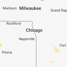
Illinois
| Local Time | Report Details |
|---|---|
| 2:33 PM CDT | Power lines down in alpha... relayed by emergency management. time estimated based on rada in henry county IL, 53.8 miles NW of Peoria, IL |
| 2:38 PM CDT | Numerous trees down blocking driveway of a home. a cement anchored flag pole bent over. siding ripped off the house. delayed repor in henry county IL, 61.4 miles NW of Peoria, IL |
| 2:40 PM CDT | Power lines down in galv in henry county IL, 40.6 miles NW of Peoria, IL |
| 2:50 PM CDT | Power lines down in kewanee... relayed by emergency management. time estimated based on rada in henry county IL, 41.8 miles NNW of Peoria, IL |
| 3:09 PM CDT | Power company reports power lines down in cambridg in henry county IL, 52.4 miles NW of Peoria, IL |
| 3:15 PM CDT | Road sign bent... corn flatted. relayed via wmbd-t in stark county IL, 28.9 miles NW of Peoria, IL |
| 3:30 PM CDT | Power line down in galesburg in knox county IL, 45.2 miles WNW of Peoria, IL |
| 3:30 PM CDT | Corn down in field in bureau county IL, 38 miles N of Peoria, IL |
| 3:45 PM CDT | 4 inch tree branches broken off at spoon river college. social media repor in fulton county IL, 28.2 miles WSW of Peoria, IL |
| 4:00 PM CDT | Large tree branch broken west of shoppes of grand prairie. relayed via wmbd-tv. time estimate in peoria county IL, 8.1 miles NW of Peoria, IL |
| 4:20 PM CDT | 6-8 inch diameter tree branch down on roadway in mark... il. report from social media. time estimate based on rada in putnam county IL, 43 miles NNE of Peoria, IL |
| 4:53 PM CDT | La salle county sheriff received a report of a tree dow in la salle county IL, 44.8 miles NE of Peoria, IL |
| 4:57 PM CDT | Small limbs down in lostan in la salle county IL, 41.5 miles NE of Peoria, IL |
| 5:18 PM CDT | 4 inch limb fell onto some power lines. occurred with the gust front ahead of the storm in sangamon county IL, 70.8 miles S of Peoria, IL |
| 6:10 PM CDT | Large tree snapped in 1400 block of west riverview st. relayed via wand-tv social medi in macon county IL, 39 miles NW of Mattoon, IL |
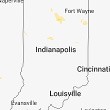
Indiana
| Local Time | Report Details |
|---|---|
| 3:33 PM EDT | Large limbs and a utility line dow in noble county IN, 36.3 miles NW of Fort Wayne, IN |
| 3:48 PM EDT | Tree limb down on roadway. time estimated by rada in noble county IN, 30.8 miles NW of Fort Wayne, IN |
| 4:43 PM EDT | Tree down on house. the tree appears to be partially rotted. time estimated by rada in marshall county IN, 65.7 miles WNW of Fort Wayne, IN |
Nebraska
| Local Time | Report Details |
|---|---|
| 3:54 PM CDT | Quarter sized hail reported near Alexandria, NE, 64.8 miles SE of Grand Island, NE |
| 4:30 PM CDT | Half Dollar sized hail reported near Hebron, NE, 73.6 miles SE of Grand Island, NE, lots of half dollar size hail. |
| 5:25 PM CDT | Quarter sized hail reported near Deshler, NE, 63.2 miles SSE of Grand Island, NE, report via twitter. |
| 5:30 PM CDT | Baseball sized hail reported near Orleans, NE, 73.9 miles SW of Grand Island, NE |
| 5:45 PM CDT | Quarter sized hail reported near Deshler, NE, 62.6 miles SSE of Grand Island, NE |
| 5:50 PM CDT | Half Dollar sized hail reported near Axtell, NE, 51 miles SW of Grand Island, NE |
| 5:08 PM MDT | Quarter sized hail reported near Bushnell, NE, 50.5 miles SSW of Scottsbluff, NE, sheriff department of kimball county reported quarter sized hail as relayed by an emergency manager officer. |
| 5:08 PM MDT | Tennis Ball sized hail reported near Bushnell, NE, 52.5 miles SSW of Scottsbluff, NE, public picture report on social media of larger then hen egg to near tennis ball sized hail south of bushnell. |
| 6:15 PM CDT | Storm damage reported in thayer county NE, 56.5 miles SSE of Grand Island, NE |
| 6:15 PM CDT | Storm damage reported in franklin county NE, 73.4 miles SW of Grand Island, NE |
| 6:20 PM CDT | Small trees branches knocked down by wind in franklin county NE, 71.4 miles SW of Grand Island, NE |
| 6:23 PM CDT | Golf Ball sized hail reported near Franklin, NE, 63.5 miles SSW of Grand Island, NE |
| 5:24 PM MDT | Quarter sized hail reported near Bushnell, NE, 51.8 miles S of Scottsbluff, NE, trained storm spotter reported quarter sized hail. |
| 6:35 PM CDT | Hen Egg sized hail reported near Franklin, NE, 63.9 miles SSW of Grand Island, NE |
| 8:19 PM CDT | Asos station mck... mccook airport measured 58 mph thunderstorm wind gus in red willow county NE, 61.1 miles NNE of Colby, KS |
| 8:29 PM CDT | Peak gust measured at mccook airpor in red willow county NE, 61.1 miles NNE of Colby, KS |
| 8:30 PM CDT | Emergency manager relayed report resident of indianola had a large tree destroyed in their yard and a camper trailer had been shifte in red willow county NE, 64.4 miles SSE of North Platte, NE |
| 8:38 PM CDT | Storm damage reported in red willow county NE, 60.3 miles SSE of North Platte, NE |
| 8:51 PM CDT | No known damage at this tim in frontier county NE, 50.4 miles SSE of North Platte, NE |
| 8:55 PM CDT | Several branches down in cambridge. time estimated from rada in furnas county NE, 66.8 miles SSE of North Platte, NE |
| 9:11 PM CDT | Storm damage reported in furnas county NE, 68.2 miles SSE of North Platte, NE |
| 9:12 PM CDT | Storm damage reported in furnas county NE, 64.4 miles SSE of North Platte, NE |
| 9:27 PM CDT | Storm damage reported in furnas county NE, 78.5 miles SE of North Platte, NE |
West Virginia
| Local Time | Report Details |
|---|---|
| 5:40 PM EDT | Caller reports 6-8" diameter tree limb down... blocking roadway near venable and 46th. time estimated via rada in kanawha county WV, 3.8 miles ESE of Charleston, WV |
| 7:00 PM EDT | Large tree blocking all lanes... tams hwy. medium sized tree limb also down at shopping center in mount hop in raleigh county WV, 48.8 miles SSE of Charleston, WV |
Ohio
| Local Time | Report Details |
|---|---|
| 5:53 PM EDT | Trees down. time and exact location estimated off rada in scioto county OH, 74.7 miles ESE of Cincinnati, OH |
Montana
| Local Time | Report Details |
|---|---|
| 4:24 PM MDT | Quarter sized hail reported near Hysham, MT, 67.2 miles ENE of Billings, MT, quarter size hail covering interstate 94 in hysham hills mp 61-64 reportedly like a sheet of ice. |
Missouri
| Local Time | Report Details |
|---|---|
| 7:07 PM CDT | Large tree... approximately 3 feet in diameter... toppled onto a house and ca in st. louis county MO, 7.2 miles WSW of Saint Louis, MO |
Oklahoma
| Local Time | Report Details |
|---|---|
| 8:32 PM CDT | Quarter sized hail reported near Hooker, OK, 80 miles SSW of Garden City, KS |
Connect with Interactive Hail Maps