

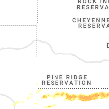
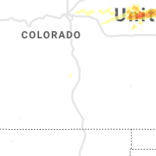
Hail Map for Thursday, June 20, 2019

Number of Impacted Households on 6/20/2019
0
Impacted by 1" or Larger Hail
0
Impacted by 1.75" or Larger Hail
0
Impacted by 2.5" or Larger Hail
Square Miles of Populated Area Impacted on 6/20/2019
0
Impacted by 1" or Larger Hail
0
Impacted by 1.75" or Larger Hail
0
Impacted by 2.5" or Larger Hail


Cities Most Affected by Hail Storms of 6/20/2019
| Hail Size | Demographics of Zip Codes Affected | ||||||
|---|---|---|---|---|---|---|---|
| City | Count | Average | Largest | Pop Density | House Value | Income | Age |
| Joes, CO | 3 | 1.75 | 1.75 | 1 | $10k | $40.4k | 45.6 |
| Vermillion, KS | 1 | 1.75 | 1.75 | 4 | $25k | $32.1k | 50.9 |
| Granite Falls, MN | 1 | 1.75 | 1.75 | 28 | $68k | $33.8k | 43.2 |
| Saint James, MN | 1 | 1.75 | 1.75 | 35 | $62k | $35.3k | 40.6 |
Hail and Wind Damage Spotted on 6/20/2019
Filter by Report Type:Hail ReportsWind Reports
States Impacted
Texas, New York, North Carolina, Vermont, Georgia, Pennsylvania, Virginia, South Carolina, Colorado, New Jersey, Tennessee, Minnesota, Montana, Nebraska, Wyoming, Kansas, IowaTexas
| Local Time | Report Details |
|---|---|
| 7:45 AM CDT | Quarter sized hail reported near Corsicana, TX, 62.7 miles SSE of Dallas, TX, quarter size hail 4 miles ese of eureka from mping. |
| 3:31 PM CDT | Storm damage reported in armstrong county TX, 38.5 miles ESE of Amarillo, TX |
New York
| Local Time | Report Details |
|---|---|
| 11:30 AM EDT | Numerous trees dow in steuben county NY, 73.8 miles SW of Syracuse, NY |
| 12:55 PM EDT | Wires down in the roadway in the vicinity of monroe st and 3rd st in ithac in tompkins county NY, 45.8 miles SSW of Syracuse, NY |
North Carolina
| Local Time | Report Details |
|---|---|
| 1:20 PM EDT | Multiple trees down countywid in yadkin county NC, 64 miles N of Charlotte, NC |
| 1:34 PM EDT | Several trees down in and around danbury. time estimated by rada in stokes county NC, 61.3 miles SSW of Roanoke, VA |
| 1:43 PM EDT | 2 trees down along the stokes county border. time estimated by rada in stokes county NC, 70.7 miles SSW of Roanoke, VA |
| 1:49 PM EDT | Multiple trees down along highway 65 in the walnut cove area of the count in stokes county NC, 69.2 miles S of Roanoke, VA |
| 2:03 PM EDT | Few trees down in the wentworth area of the county. time estimated by rada in rockingham county NC, 60.8 miles S of Roanoke, VA |
| 2:04 PM EDT | Several trees reported down and in roadways across the winston- salem are in forsyth county NC, 71.4 miles S of Roanoke, VA |
| 2:05 PM EDT | Trained spotter reported multiple trees down along ostwalt-amity rd and houston rd near the ostwalt communit in iredell county NC, 31.6 miles N of Charlotte, NC |
| 2:11 PM EDT | One tree down on turner drive. time estimated by rada in rockingham county NC, 66.1 miles SSE of Roanoke, VA |
| 2:11 PM EDT | Tree down on house on briggs s in rockingham county NC, 66 miles SSE of Roanoke, VA |
| 2:12 PM EDT | Thunderstorm winds blew a tree on a house at two separate locations on lawsonville avenu in rockingham county NC, 65 miles SSE of Roanoke, VA |
| 2:14 PM EDT | Several trees down on pleasant ridge rd. between lewiston rd. and bunch rd. time estimated based on rada in guilford county NC, 75.3 miles WNW of Raleigh, NC |
| 2:14 PM EDT | Tree down blocking spencer dixon rd. near kellam ridge d in guilford county NC, 70.9 miles WNW of Raleigh, NC |
| 2:14 PM EDT | A few trees down around the williamsburg community in rockingham count in rockingham county NC, 63.5 miles WNW of Raleigh, NC |
| 2:21 PM EDT | Tree down blocking doggett rd near bridge over lake townsen in guilford county NC, 67.8 miles WNW of Raleigh, NC |
| 2:21 PM EDT | Utility pole blown over into hous in guilford county NC, 72.7 miles WNW of Raleigh, NC |
| 2:30 PM EDT | Tree into hous in guilford county NC, 68 miles WNW of Raleigh, NC |
| 2:30 PM EDT | Multiple trees down across the county. emergency management reports trees blocking several roads... including at leasburg; trees over route 62 between bethel and milton in caswell county NC, 57.7 miles NW of Raleigh, NC |
| 2:32 PM EDT | Tree down blocking east cone blvd near us-29 nort in guilford county NC, 66 miles WNW of Raleigh, NC |
| 2:35 PM EDT | Tree down blocking yanceyville st. near east cone blv in guilford county NC, 67.6 miles WNW of Raleigh, NC |
| 2:35 PM EDT | At least two trees were blown down by strong thunderstorm winds near powell lane off of highway 8 in caswell county NC, 53.6 miles NW of Raleigh, NC |
| 2:38 PM EDT | Tree onto house on james place near guest stree in guilford county NC, 67.3 miles WNW of Raleigh, NC |
| 2:39 PM EDT | Wind gust of 58mph measured at 2:39p in caswell county NC, 47.4 miles NW of Raleigh, NC |
| 2:45 PM EDT | Thunderstorm winds downed several trees in and around hyco lake. two lake weather stations of unknown elevation and siting recorded gusts of 68 and 71mph as the storms in person county NC, 51.9 miles NNW of Raleigh, NC |
| 2:45 PM EDT | Numerous trees down around southern portions of hyco lake... especially along wagstaff carver r in person county NC, 49.5 miles NNW of Raleigh, NC |
| 2:50 PM EDT | Police and fire is responding to report of tree on house in the burlington are in alamance county NC, 50.2 miles WNW of Raleigh, NC |
| 2:50 PM EDT | Large tree and power line down at intersection of mcgees mill and mt carmel road. time estimated by rada in halifax county VA, 57 miles NNW of Raleigh, NC |
| 2:51 PM EDT | Tree down on a house south of hurdle mill in person county NC, 39.9 miles NW of Raleigh, NC |
| 2:57 PM EDT | Tree down on a house on the 1800 block of high plains roa in person county NC, 52.6 miles NNW of Raleigh, NC |
| 2:59 PM EDT | Tree and power pole down blocking randolph st. time estimated based on rada in randolph county NC, 65.6 miles W of Raleigh, NC |
| 3:01 PM EDT | Corrects previous tstm wnd dmg report from burlington. 5 power lines and 3 trees reported down in the burlington are in alamance county NC, 49.7 miles WNW of Raleigh, NC |
| 3:01 PM EDT | Large tree on a house on chambers loop rd. near riverbend wa in person county NC, 37.1 miles NNW of Raleigh, NC |
| 3:02 PM EDT | Tree down blocking roadway in burlington near virginia ave. and north main street. time estimated based on rada in alamance county NC, 49.2 miles WNW of Raleigh, NC |
| 3:02 PM EDT | Corrects previous tstm wnd dmg report from 2 ne burlington. tree down blocking roadway in burlington near virginia ave. and north main street. time estimated based on r in alamance county NC, 49.2 miles WNW of Raleigh, NC |
| 3:03 PM EDT | Tree down on unoccupied vehicle and blocking roadway near the intersection of tucker st. and fix st. time estimated based on rada in alamance county NC, 49.1 miles WNW of Raleigh, NC |
| 3:04 PM EDT | Tree reported down near the intersection of hanford rd. and cedarcrest dr. time estimated based on rada in alamance county NC, 48 miles WNW of Raleigh, NC |
| 3:09 PM EDT | Tree down on a house on the 1100 block of chambers loop roa in person county NC, 37.1 miles NNW of Raleigh, NC |
| 3:10 PM EDT | Tree down along south fayetteville st. in liberty. time estimated based on rada in randolph county NC, 52.3 miles W of Raleigh, NC |
| 3:20 PM EDT | 5 power lines and 3 trees reported down in the burlington are in alamance county NC, 49.7 miles WNW of Raleigh, NC |
| 3:23 PM EDT | Long stretch of power lines reported down along east franklin st. starting at intersection with plant rd. time is radar-estimate in orange county NC, 24.4 miles WNW of Raleigh, NC |
| 3:25 PM EDT | Large tree down near intersection of bradshaw quarry rd. and vernon r in orange county NC, 35.3 miles WNW of Raleigh, NC |
| 3:28 PM EDT | Reports of multiple trees down in downtown durha in durham county NC, 20.7 miles NW of Raleigh, NC |
| 3:34 PM EDT | Tree fell in residential structure in chapel hill. time estimated by rada in orange county NC, 25.5 miles WNW of Raleigh, NC |
| 3:40 PM EDT | Multiple trees reported dow in chatham county NC, 40.9 miles W of Raleigh, NC |
| 3:45 PM EDT | Multiple trees reported down. time estimated by rada in halifax county NC, 61 miles NE of Raleigh, NC |
| 3:45 PM EDT | Multiple trees reported down in the towns of butner and creedmoo in granville county NC, 23.5 miles N of Raleigh, NC |
| 3:50 PM EDT | Several trees down near warrento in warren county NC, 51.2 miles NE of Raleigh, NC |
| 3:53 PM EDT | Tree reported down in roadway on wicker dr. near intersection with atlantic ave. time estimated based on rada in wake county NC, 2.1 miles NE of Raleigh, NC |
| 4:00 PM EDT | 911 call center reported trees down on rainey rd. time estimated from rada in rowan county NC, 33 miles NE of Charlotte, NC |
| 4:00 PM EDT | Fire dept/rescue reported a tree down on a house on crescent r in rowan county NC, 32.4 miles NE of Charlotte, NC |
| 4:05 PM EDT | Fire dept/rescue reported trees and power lines down on eastville dr at hwy 5 in rowan county NC, 34.1 miles NE of Charlotte, NC |
| 4:05 PM EDT | Trees down. time estimated from rada in northampton county NC, 69.2 miles S of Richmond, VA |
| 4:14 PM EDT | Tree blocking roadway on nc-22 near intersection with old liberty rd. time estimated based on rada in randolph county NC, 59.4 miles W of Raleigh, NC |
| 4:15 PM EDT | Trees down. time estimated from rada in northampton county NC, 72.8 miles S of Richmond, VA |
| 4:20 PM EDT | Fire dept/rescue reported a tree down on a house on joe cloninger r in gaston county NC, 23.4 miles WNW of Charlotte, NC |
| 4:20 PM EDT | Extensive trees... power lines... and power poles down at thomas a betts pkwy and us 301 s near north carolina wesleyan colleg in edgecombe county NC, 51.3 miles ENE of Raleigh, NC |
| 4:24 PM EDT | Thunderstorm winds downed a few trees near the intersection of old milburnie road and knightdale blvd temporarily closing i in wake county NC, 6.4 miles E of Raleigh, NC |
| 4:25 PM EDT | Downed trees impeding traffic on i95 northbound near mile marker 140 in rocky moun in nash county NC, 46.3 miles ENE of Raleigh, NC |
| 4:30 PM EDT | Trees down. time estimated from rada in northampton county NC, 76.2 miles WSW of Virginia Beach, VA |
| 4:33 PM EDT | Tree blocking new hope rd. near intersection with nc-49 south. time estimated based on rada in randolph county NC, 53.3 miles ENE of Charlotte, NC |
| 4:34 PM EDT | Trees down. time estimated from rada in northampton county NC, 68.6 miles WSW of Virginia Beach, VA |
| 4:35 PM EDT | Trees down. time estimated from rada in northampton county NC, 65.1 miles WSW of Virginia Beach, VA |
| 4:40 PM EDT | 911 call center reported numerous trees down in concord. time estimated from rada in cabarrus county NC, 19.9 miles NE of Charlotte, NC |
| 4:40 PM EDT | Fire dept/rescue reported a tree down on a house on union new hope r in gaston county NC, 13.8 miles W of Charlotte, NC |
| 4:40 PM EDT | Tree blocking lassiter mill rd near intersection with waynick meadow rd. time estimated based on rada in randolph county NC, 56.3 miles ENE of Charlotte, NC |
| 4:40 PM EDT | Amateur radio reported trees down on yorktown st in concord. time estimated from rada in cabarrus county NC, 19 miles NE of Charlotte, NC |
| 4:41 PM EDT | Trees down at 1353 nc561 aulander... n in hertford county NC, 66.4 miles WSW of Virginia Beach, VA |
| 4:41 PM EDT | Multiple reports of trees down on roads in and around murfreesboro. time estimated from rada in hertford county NC, 62.3 miles WSW of Virginia Beach, VA |
| 4:45 PM EDT | Several reports of trees down in como... nc. time estimated from rada in hertford county NC, 55.2 miles WSW of Virginia Beach, VA |
| 4:45 PM EDT | Trees down. time estimated from rada in hertford county NC, 57.4 miles WSW of Virginia Beach, VA |
| 4:50 PM EDT | Amateur radio reported trees and power lines down on ridge rd between 485 and mallard creek r in mecklenburg county NC, 10.5 miles NNE of Charlotte, NC |
| 4:50 PM EDT | Multiple reports of trees down on roadways in and around ahoskie... nc. time estimated from rada in hertford county NC, 60.9 miles WSW of Virginia Beach, VA |
| 4:51 PM EDT | Several reports of trees down in winton... nc. time estimated from rada in hertford county NC, 55.1 miles WSW of Virginia Beach, VA |
| 4:54 PM EDT | Trees down on nc 45 in cofield... nc. time estimated from rada in hertford county NC, 54.6 miles WSW of Virginia Beach, VA |
| 4:57 PM EDT | Trees down. reported at evanstown rd harrellsville... nc. time estimated from rada in hertford county NC, 53.5 miles SW of Virginia Beach, VA |
| 5:00 PM EDT | Trees and power lines dow in bertie county NC, 75.8 miles WSW of Virginia Beach, VA |
| 5:00 PM EDT | Trained spotter reported multiple trees down near gold hill mines historic park. time estimated from rada in rowan county NC, 34.4 miles NE of Charlotte, NC |
| 5:03 PM EDT | Trees and power lines dow in bertie county NC, 76.7 miles SW of Virginia Beach, VA |
| 5:10 PM EDT | Tree down on power line with power outages. report via social medi in gates county NC, 37.5 miles SW of Virginia Beach, VA |
| 5:10 PM EDT | Thunderstorm winds downed several trees along 109 south near the intersection of jim elliott roa in davidson county NC, 48.4 miles ENE of Charlotte, NC |
| 5:11 PM EDT | Numerous trees and power lines down in the new london are in stanly county NC, 38.2 miles ENE of Charlotte, NC |
| 5:14 PM EDT | Numerous trees down in southwest chatham county... south of siler cit in chatham county NC, 48.6 miles WSW of Raleigh, NC |
| 5:16 PM EDT | Thunderstorm winds downed at least two additional trees along new hope road in southern randolph count in randolph county NC, 52.2 miles ENE of Charlotte, NC |
| 5:25 PM EDT | Transformer and power lines down in the 900 block of nc route 34 in camden county NC, 27.1 miles SSW of Virginia Beach, VA |
| 5:27 PM EDT | Trees down across firetower r in pasquotank county NC, 28.8 miles SW of Virginia Beach, VA |
| 5:37 PM EDT | Tractor trailer blown over by strong winds on route 17 bypas in pasquotank county NC, 33.1 miles SSW of Virginia Beach, VA |
| 5:39 PM EDT | Several trees down along hwy 3 in currituck county NC, 23.9 miles S of Virginia Beach, VA |
| 5:40 PM EDT | Numerous trees and power lines dow in montgomery county NC, 49.2 miles E of Charlotte, NC |
| 5:40 PM EDT | Two large trees reported dow in scotland county NC, 83.3 miles ESE of Charlotte, NC |
| 5:45 PM EDT | Powerlines down on highway 32n... near pinetown. time estimated based on radar dat in beaufort county NC, 85 miles SSW of Virginia Beach, VA |
| 5:55 PM EDT | Numerous trees and power lines dow in montgomery county NC, 62.8 miles E of Charlotte, NC |
| 5:58 PM EDT | Multiple trees... large limbs and power lines down along the south end of knotts island. report via social medi in currituck county NC, 19.8 miles SSE of Virginia Beach, VA |
| 5:59 PM EDT | Trees down on highway 99n... north of pantego. time estimated based on radar dat in beaufort county NC, 84.7 miles SSW of Virginia Beach, VA |
| 6:00 PM EDT | Trees down and topped off along caratoke hw in currituck county NC, 40.5 miles SSE of Virginia Beach, VA |
| 6:04 PM EDT | Several power lines down. time estimated by rada in dare county NC, 43.9 miles SSE of Virginia Beach, VA |
| 6:05 PM EDT | Duck pie in dare county NC, 43.2 miles SSE of Virginia Beach, VA |
| 6:06 PM EDT | Multiple trees down. time estimated by rada in dare county NC, 47.5 miles SSE of Virginia Beach, VA |
| 6:07 PM EDT | Uprooted 11 inch diameter tree on shore dr in garne in wake county NC, 8 miles S of Raleigh, NC |
| 6:08 PM EDT | Thunderstorm winds downed a tree along vandora springs road between n hall blvd and miriam avenue. time estimated via rada in wake county NC, 6.6 miles S of Raleigh, NC |
| 6:15 PM EDT | Several trees dow in dare county NC, 56 miles SSE of Virginia Beach, VA |
| 6:16 PM EDT | Alligator river bridg in amz131 county NC, 59 miles S of Virginia Beach, VA |
| 6:16 PM EDT | 63 mph wind gust reported near alligator river bridg in tyrrell county NC, 58.3 miles S of Virginia Beach, VA |
| 6:16 PM EDT | Two trees down on deep river rd near us 1. radar estimated tim in lee county NC, 28.9 miles WSW of Raleigh, NC |
| 6:21 PM EDT | Multiple power lines down. time estimated by rada in dare county NC, 55.4 miles SSE of Virginia Beach, VA |
| 6:49 PM EDT | Wunderground station at caswell dunes in brunswick county NC, 24 miles SSW of Wilmington, NC |
| 7:08 PM EDT | Wrightsville buoy - station 41038 in amz250 county NC, 14.5 miles ESE of Wilmington, NC |
Vermont
| Local Time | Report Details |
|---|---|
| 1:40 PM EDT | Tree down on powerline in rutland county VT, 67.1 miles S of Burlington, VT |
| 1:42 PM EDT | Tree down on forest street/no power in rutland county VT, 60.9 miles S of Burlington, VT |
| 1:45 PM EDT | Tree on powerlin in rutland county VT, 58.7 miles SSE of Burlington, VT |
| 2:30 PM EDT | Tree down and power outage on middle roa in rutland county VT, 67.4 miles SSE of Burlington, VT |
| 2:40 PM EDT | Multiple trees and limbs on power lines near hartford/west hartfor in windsor county VT, 65.4 miles SE of Burlington, VT |
| 2:42 PM EDT | Tree down on powerline near norwich in windsor county VT, 69.2 miles SE of Burlington, VT |
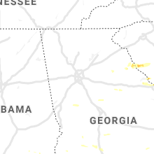
Georgia
| Local Time | Report Details |
|---|---|
| 1:55 PM EDT | Several large trees down and aluminum bleachers blown over at lamar murphy park in jackson county GA, 55.2 miles ENE of Atlanta, GA |
| 2:25 PM EDT | 1-2 trees down near us78 and yancy r in oglethorpe county GA, 67.6 miles E of Atlanta, GA |
| 2:42 PM EDT | 1-2 trees down near us78 and yancy r in oglethorpe county GA, 67.6 miles E of Atlanta, GA |
| 3:00 PM EDT | 911 call center reported trees down on washington hw in elbert county GA, 53 miles SSW of Greenville, SC |
| 3:00 PM EDT | 911 call center reported trees down on mineral springs rd & fleming road ex in elbert county GA, 52.8 miles SSW of Greenville, SC |
| 3:00 PM EDT | 911 call center reported trees down on bakers ferry rd & edison r in elbert county GA, 54.8 miles S of Greenville, SC |
| 3:05 PM EDT | Reports of numerous trees down near greenville including damage around the town squar in meriwether county GA, 52.8 miles SSW of Atlanta, GA |
| 3:10 PM EDT | At least 4 trees down at render garrett rd and ga hwy 10 in meriwether county GA, 52.2 miles SSW of Atlanta, GA |
| 3:11 PM EDT | Law enforcement reported a power outage due to wind from a severe thunderstorm on shoreline drive in lincoln county. time estimated by rada in lincoln county GA, 45.4 miles NW of Augusta, GA |
| 3:15 PM EDT | 911 call center reported a large area of about 40 trees down on wahatchee creek r in elbert county GA, 52.7 miles S of Greenville, SC |
| 3:18 PM EDT | Two trees down on lawrence mill rd near kelly rd in pike county GA, 52.6 miles S of Atlanta, GA |
| 3:18 PM EDT | Tree blown down on power lines on hwy 85 near greenville flat shoals rd in meriwether county GA, 47.9 miles SSW of Atlanta, GA |
| 3:23 PM EDT | Reported trees down along gills point road near lake thurmon in lincoln county GA, 48 miles NW of Augusta, GA |
| 3:35 PM EDT | Utility company reported a tree down on indian rd... also knocking down power lines in lincoln county. time estimated by rada in lincoln county GA, 34.9 miles NW of Augusta, GA |
| 3:35 PM EDT | Tree down at intersection of delray rd and rocky bottom r in upson county GA, 55.4 miles S of Atlanta, GA |
| 3:56 PM EDT | Total of 50-100 trees down beginning at 42 south and maynards mill rd... continuing eas in monroe county GA, 57.4 miles SSE of Atlanta, GA |
| 4:14 PM EDT | Gdot reports 2 trees down on i-75 sb blocking all lanes at exit 172 at bass rd in bibb county GA, 68.1 miles SE of Atlanta, GA |
| 4:35 PM EDT | The asos at thomson-mcduffie county airport recorded a wind gust of 69 mp in mcduffie county GA, 31.6 miles W of Augusta, GA |
| 4:40 PM EDT | At least 1 tree down at intersection of ga hwy 49 and forest hill rd s in baldwin county GA, 79.8 miles SE of Atlanta, GA |
| 4:43 PM EDT | Trees down at highway 82 and moore station roa in randolph county GA, 68.3 miles SSE of Auburn, AL |
| 4:51 PM EDT | Tree down on powerline on ga hwy 39... just west of the intersection of hwy 27 in stewart county GA, 49.5 miles SE of Auburn, AL |
| 4:51 PM EDT | Tree down on ga hwy 27 at mm 10 near the intersection of canyon r in stewart county GA, 54.9 miles SE of Auburn, AL |
| 4:55 PM EDT | Trees down along benevolence highwa in randolph county GA, 69.1 miles SE of Auburn, AL |
| 5:23 PM EDT | Trees down on 300 to 700 block of scenic route near lake blackshear in crisp county GA, 69.8 miles WNW of Douglas, GA |
| 5:30 PM EDT | 2-3 trees down on ga hwy 27 at mile marker 7... ne of intersection with snow r in pulaski county GA, 63.4 miles NW of Douglas, GA |
| 5:45 PM EDT | Tree down on ga 17 in jenkins county GA, 45.8 miles S of Augusta, GA |
| 5:53 PM EDT | Tree down on us hwy 25 in jenkins county GA, 42 miles S of Augusta, GA |
| 6:10 PM EDT | Tree down on bay branch roa in screven county GA, 50.8 miles SSE of Augusta, GA |
| 6:12 PM EDT | Tree down on ga hwy 17s near county lin in jenkins county GA, 53.3 miles S of Augusta, GA |
| 6:15 PM EDT | Tree down on highway 313 at medder in worth county GA, 61.1 miles W of Douglas, GA |
| 6:15 PM EDT | Screven 911 reported a tree down on a power line and partially blocking the road on n main st in sylvani in screven county GA, 53.2 miles SSE of Augusta, GA |
| 6:17 PM EDT | Tree down on brannens bridge roa in screven county GA, 53.7 miles SSE of Augusta, GA |
| 6:20 PM EDT | 2 trees down near bluffton roa in calhoun county GA, 82.7 miles NNW of Tallahassee, FL |
| 6:23 PM EDT | Tree down on cannon roa in turner county GA, 50.8 miles WNW of Douglas, GA |
| 6:25 PM EDT | Tree down at isabella terrell rd close to worth turner r in worth county GA, 54.9 miles W of Douglas, GA |
| 6:30 PM EDT | Part of a tree blocking half of the south bound lane on highway 82 wes in worth county GA, 62.7 miles W of Douglas, GA |
| 6:30 PM EDT | Several trees down in early count in early county GA, 75.7 miles NNW of Tallahassee, FL |
| 6:30 PM EDT | Tree down on highway 107 between lands crossing and prospect church r in irwin county GA, 34.1 miles WNW of Douglas, GA |
| 6:30 PM EDT | Tree down on dirt end of bussell pond off of pinett in irwin county GA, 31.1 miles WNW of Douglas, GA |
| 6:33 PM EDT | Tree down between ocilla and tifton... ga near highway 31 in irwin county GA, 30.9 miles W of Douglas, GA |
| 6:45 PM EDT | Bulloch 911 reported a power line down on randy lowery r in bulloch county GA, 47.4 miles NW of Savannah, GA |
| 6:55 PM EDT | Tree was reported down in broxton. time estimated from rada in coffee county GA, 8.2 miles NNW of Douglas, GA |
| 6:55 PM EDT | Tree down on mcgirt st in poula in worth county GA, 54.9 miles W of Douglas, GA |
| 7:00 PM EDT | Several trees reported down in the area by 911 cente in baker county GA, 63.9 miles N of Tallahassee, FL |
| 7:08 PM EDT | Multiple power lines down in atkinson county... with 2 trees reported down near willacoche in atkinson county GA, 16.4 miles SW of Douglas, GA |
| 7:10 PM EDT | Tree across the line on tyty whiddon mill roa in tift county GA, 46.7 miles W of Douglas, GA |
| 7:10 PM EDT | Trees and powerlines reported down in willacoochee are in atkinson county GA, 16.4 miles SW of Douglas, GA |
| 7:20 PM EDT | Tree down near 200 camp ground church rd in coffee count in bacon county GA, 16.9 miles ENE of Douglas, GA |
| 7:20 PM EDT | Tree down near stagecoach roa in mitchell county GA, 60.9 miles N of Tallahassee, FL |
| 7:30 PM EDT | Bulloch 911 reported a tree down near the intersection of ga169 and ga12 in evans county GA, 51.6 miles W of Savannah, GA |
| 7:35 PM EDT | Reports of trees and power lines down throughout appling county... with reports of trees having fallen on vehicles... but no structural damage has been observe in appling county GA, 34.3 miles ENE of Douglas, GA |
| 7:39 PM EDT | Bulloch 911 reported a tree down on golf club dr at us301 in evans county GA, 47.5 miles W of Savannah, GA |
| 7:40 PM EDT | Reports of countywide trees and powerlines down across pierce count in pierce county GA, 39.3 miles ESE of Douglas, GA |
| 7:40 PM EDT | Multiple trees and power lines reported down throughout the northern portions of ware count in ware county GA, 19.8 miles ESE of Douglas, GA |
| 7:44 PM EDT | Bulloch 911 reported a tree down on deloach church rd at nevills groveland r in bulloch county GA, 41 miles WNW of Savannah, GA |
| 7:58 PM EDT | A few trees down near highway 125 just northwest of nashville... g in berrien county GA, 32.8 miles SW of Douglas, GA |
| 8:00 PM EDT | Several trees down in early count in early county GA, 68.2 miles NW of Tallahassee, FL |
| 8:15 PM EDT | Multiple reports of trees and power lines down in wayne county... with 2-3 trees reported down near screve in wayne county GA, 49 miles E of Douglas, GA |
Pennsylvania
| Local Time | Report Details |
|---|---|
| 2:45 PM EDT | Downed tree into wires on parkersville road. time estimated from rada in chester county PA, 65.8 miles NE of Baltimore, MD |
| 3:03 PM EDT | Matsonford road blocked in both directions between i-76 and i-476 due to a fallen tre in montgomery county PA, 82.3 miles WSW of Brooklyn, NY |
Virginia
| Local Time | Report Details |
|---|---|
| 2:58 PM EDT | Several trees down along us 501 blocking southbound lane in halifax county VA, 55.3 miles NNW of Raleigh, NC |
| 3:01 PM EDT | Trees down on christie road. report from wset-t in halifax county VA, 53.9 miles NNW of Raleigh, NC |
| 3:01 PM EDT | Corrects previous tstm wnd dmg report from 3 w virgilina. trees down on christie road and virgilina road. report from wset-t in halifax county VA, 53.9 miles NNW of Raleigh, NC |
| 3:03 PM EDT | Trees down on cemetery road. reported from wset-t in halifax county VA, 53.4 miles N of Raleigh, NC |
| 3:06 PM EDT | Halifax emergency management reported approximately 30 trees uprooted or snapped at the 5200 block of red bank roa in halifax county VA, 55.2 miles N of Raleigh, NC |
| 3:07 PM EDT | Photos sent via social media show a large tree uprooted in the red bank are in halifax county VA, 56.5 miles N of Raleigh, NC |
| 3:25 PM EDT | Numerous trees downed across the sw part of mecklenburg count in mecklenburg county VA, 55.5 miles N of Raleigh, NC |
| 4:00 PM EDT | Tree down on doctor purdy road. time approximated by rada in brunswick county VA, 64.2 miles SSW of Richmond, VA |
| 4:45 PM EDT | Several trees down in southampton count in southampton county VA, 58.2 miles W of Virginia Beach, VA |
| 5:14 PM EDT | Multiple trees and large branches down and blocking roads. report via social medi in city of suffolk county VA, 36.3 miles WSW of Virginia Beach, VA |
| 5:42 PM EDT | Tree down blocking kilby driv in city of chesapeake county VA, 8.4 miles W of Virginia Beach, VA |
| 6:04 PM EDT | Lynnhaven inlet light mesonet statio in anz634 county VA, 10.8 miles N of Virginia Beach, VA |
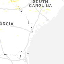
South Carolina
| Local Time | Report Details |
|---|---|
| 3:09 PM EDT | Reported numerous trees down along tate road... which is east of the town of mount came in mccormick county SC, 47.1 miles NW of Augusta, GA |
| 3:20 PM EDT | Fire dept/rescue reported trees down on mt carmel rd. time estimated from rada in abbeville county SC, 49.5 miles SSE of Greenville, SC |
| 3:20 PM EDT | Law enforcement reported multiple trees and powerlines down on sc 28 between abbeville and clatworthy crossroads. time estimated from rada in abbeville county SC, 48.1 miles NNW of Augusta, GA |
| 3:20 PM EDT | Fire dept/rescue reported a tree down on a house on candy branch rd. multiple trees down on candy branch r in abbeville county SC, 46 miles NNW of Augusta, GA |
| 3:25 PM EDT | Schp reported a tree down at highway 10 and mccormick highway. time estimated from rada in greenwood county SC, 38.9 miles NNW of Augusta, GA |
| 3:25 PM EDT | Schp reported a tree down at highway 10 and creswell rd. time estimated from rada in greenwood county SC, 44.3 miles NNW of Augusta, GA |
| 3:25 PM EDT | Emergency mngr reported widespread downed trees and powerlines across southwest greenwood county. us 25 us 221 and sc 10 are all blocked. multiple reports of trees down in greenwood county SC, 43.9 miles NNW of Augusta, GA |
| 3:35 PM EDT | Public reported multiple trees down on hollingsworth rd blocking a residential driveway and causing power outages. time estimated from rada in greenwood county SC, 42.5 miles N of Augusta, GA |
| 3:36 PM EDT | Schp reported a tree in roadway at us378 and sc430 in edgefield county. time estimated by rada in saluda county SC, 34.6 miles N of Augusta, GA |
| 3:36 PM EDT | Schp reported a tree down in road way at state rd s-36-49. time estimated by radar 3:36 p in newberry county SC, 55.4 miles NNE of Augusta, GA |
| 3:40 PM EDT | Schp reported a tree in roadway at us25 and us378 in edgefield county. time estimated by rada in edgefield county SC, 31.4 miles N of Augusta, GA |
| 3:44 PM EDT | Fire dept/rescue reported a tree down on a house on candy branch r in abbeville county SC, 46 miles NNW of Augusta, GA |
| 3:48 PM EDT | Reported a tree down near the town of livingsto in orangeburg county SC, 49.6 miles E of Augusta, GA |
| 3:54 PM EDT | Schp reported a tree in roadway at us321 byp and plantation rd in fairfield county. time estimated by rada in fairfield county SC, 69 miles S of Charlotte, NC |
| 3:54 PM EDT | Schp reported a tree down in road way at interstate 26 80 eb. time estimated by radar 3:54 p in newberry county SC, 61.6 miles NNE of Augusta, GA |
| 3:59 PM EDT | Multiple trees down on 2 mobile home in florence county SC, 65.3 miles NNE of Charleston, SC |
| 4:00 PM EDT | Tree in roadway wildflower road and muller road. time estinated by rada in richland county SC, 70.4 miles S of Charlotte, NC |
| 4:01 PM EDT | Reported trees down near the intersection of beechcreek road and old cherokee roa in lexington county SC, 53 miles NE of Augusta, GA |
| 4:01 PM EDT | County em reported damage in the vicinity of todd creek road and highway 400... norway road. this includes several trees down with some trees topped... a tree on a resi in orangeburg county SC, 52.9 miles E of Augusta, GA |
| 4:06 PM EDT | Schp reported tree down on sc 400 at wendover av in orangeburg county SC, 52.9 miles E of Augusta, GA |
| 4:13 PM EDT | Schp reported a tree down in road way us 21 near simmons funeral home. time estimated by radar 4:13 p in orangeburg county SC, 54.1 miles WNW of Charleston, SC |
| 4:13 PM EDT | Amateur reported reported a tree down in road way at beechcreek road and old cherokee road. time estimated by rada in lexington county SC, 53 miles NE of Augusta, GA |
| 4:20 PM EDT | Schp reported multiple trees down along cordova road... between cheery hill and rivelo in orangeburg county SC, 54.8 miles WNW of Charleston, SC |
| 4:20 PM EDT | Skywarn spotter via ham radio reported numerous trees down in the city of elgin. no other specific details. time estimated by rada in kershaw county SC, 72.6 miles S of Charlotte, NC |
| 4:20 PM EDT | Tree uprooted and down on power lines on sunset blvd. spotter report relayed via il in lexington county SC, 61.4 miles NE of Augusta, GA |
| 4:22 PM EDT | A social media user reported a tree on roadway at cromer rd of 378 in lexington county. time estimated by rada in lexington county SC, 60 miles NE of Augusta, GA |
| 4:22 PM EDT | A social media user reported a power outage in west columbia due to downed trees on leaphart rd at us378 and near queen parkway... knocking down power lines. time estim in lexington county SC, 60.4 miles NE of Augusta, GA |
| 4:24 PM EDT | Skywarn spotter via ham radio reported multiple trees down in the vicinity of the camden airport. time estimated by rada in kershaw county SC, 66.9 miles SSE of Charlotte, NC |
| 4:25 PM EDT | *** 1 fatal *** tree fell and killed a 61 year old male in his backyard on columbia avenu in richland county SC, 65 miles NE of Augusta, GA |
| 4:26 PM EDT | Kogb measured a wind gust of 64 mp in orangeburg county SC, 52.3 miles WNW of Charleston, SC |
| 4:27 PM EDT | Jim hamilton owens airport measured wind gus in richland county SC, 65.6 miles ENE of Augusta, GA |
| 4:29 PM EDT | A social media user reported a tree uprooted at bull and gervais st in downtown columbia in richland county. time estimated by rada in richland county SC, 65.2 miles NE of Augusta, GA |
| 4:30 PM EDT | William brice stadium mesonet sit in richland county SC, 64.6 miles ENE of Augusta, GA |
| 4:30 PM EDT | Social media reported a large tree limb down on a car at providence hospital in richland county. time estimated by rada in richland county SC, 66.9 miles NE of Augusta, GA |
| 4:35 PM EDT | Tree down - deveraux and adger road columba per wltx t in richland county SC, 67.1 miles ENE of Augusta, GA |
| 4:35 PM EDT | Schp reports tree in roadway on i-26 at mile marker in richland county SC, 68.1 miles ENE of Augusta, GA |
| 4:36 PM EDT | Schp reported tree in roadway hwy 301 at sc332. time estimated by rada in orangeburg county SC, 56.9 miles E of Augusta, GA |
| 4:39 PM EDT | Tree down at ham road and us route 7 in florence county SC, 63.7 miles N of Charleston, SC |
| 4:40 PM EDT | Large tree down on atlas road in front of bible way church. the road is impassable. wis t in richland county SC, 65.5 miles ENE of Augusta, GA |
| 4:41 PM EDT | Schp reported a tree down in road way at interstate 95 116 sb. time estimated by radar 4:41 p in clarendon county SC, 36.1 miles NNW of Charleston, SC |
| 4:45 PM EDT | Schp reported tree in roadway on i-20... mile marker 145. time estimated by rada in orangeburg county SC, 53 miles WNW of Charleston, SC |
| 4:48 PM EDT | Schp reported a tree down on roadway at 3855 furman field rd and grant china ln. time estimated by rada in sumter county SC, 63.9 miles NNW of Charleston, SC |
| 4:48 PM EDT | Schp reported a tree down in road way at tb wright road and camden highway. time estimated by rada in sumter county SC, 66.7 miles NNW of Charleston, SC |
| 4:48 PM EDT | Schp reports tree in roadway i-20 at mile marker 158 westbound. time estimated by rada in orangeburg county SC, 40.8 miles WNW of Charleston, SC |
| 4:50 PM EDT | A social media user reported a large tree down on sudlow lake rd and ascuaga lake rd... knocking down power lines... in aiken county. time estimated by rada in aiken county SC, 6.4 miles NNE of Augusta, GA |
| 4:52 PM EDT | Powerlines down at the intersection of francis marion road and u.s route 301/7 in florence county SC, 72.1 miles NNE of Charleston, SC |
| 4:52 PM EDT | Schp reports tree in roadway i-20 at highway 19 in aiken county SC, 15.3 miles NE of Augusta, GA |
| 4:52 PM EDT | Corrects previous tstm wnd dmg report from 7 nnw aiken. schp reports power lines in roadway i-20 at highway 19 in aiken county SC, 15.3 miles NE of Augusta, GA |
| 4:54 PM EDT | Schp reports tree in roadway... i-20 at mile marker 1 e in aiken county SC, 4.4 miles NNW of Augusta, GA |
| 4:57 PM EDT | Trees and powerlines down i-20 and highway 2 in aiken county SC, 5.9 miles NNE of Augusta, GA |
| 4:57 PM EDT | Broadcast media reported trees and power lines down on whitehall rd and prince william dr in aiken county. time estimated by rada in aiken county SC, 6.4 miles NNE of Augusta, GA |
| 4:57 PM EDT | Report of a tree down on house at ashley circle and whatley st in aiken county. time estimated by rada in aiken county SC, 5.3 miles NNE of Augusta, GA |
| 5:00 PM EDT | Multiple trees reported down along ascauga lake and sleep hollow road. in aiken county SC, 6.7 miles NE of Augusta, GA |
| 5:00 PM EDT | Schp reported a tree down in road way at oakdale ave and whatley road. time estimated by rada in aiken county SC, 4.7 miles NNE of Augusta, GA |
| 5:04 PM EDT | Trees are down across oates highway in darlington county headed toward the bridge at i-20. road may be impassabl in darlington county SC, 69.9 miles N of Charleston, SC |
| 5:06 PM EDT | Schp reported tree in roadway homestead road and nassau driv in orangeburg county SC, 40.5 miles WNW of Charleston, SC |
| 5:07 PM EDT | Schp reported a tree down in road way at lewis road and kingsbury road... sumter county. time estimated by rada in sumter county SC, 52.1 miles NNW of Charleston, SC |
| 5:09 PM EDT | Schp reported a tree in roadway at gregg st and a p nivens st in aiken county. time estimated by rada in aiken county SC, 11.1 miles ENE of Augusta, GA |
| 5:10 PM EDT | Tree partially blocking road breezy hill road and old cherokee indian roa in aiken county SC, 10 miles NE of Augusta, GA |
| 5:10 PM EDT | Schp reported a tree down in road way at hazel street and elizabeth ave. time estimated by rada in aiken county SC, 3.8 miles NNE of Augusta, GA |
| 5:11 PM EDT | Schp reported a tree down in road way at 3175 florence highway and goza road. time estimated by rada in sumter county SC, 54.4 miles NNW of Charleston, SC |
| 5:12 PM EDT | Schp reported multiple trees with power lines down on conger drive... evans drive and ivy circle. time estimated by rada in aiken county SC, 14.6 miles ENE of Augusta, GA |
| 5:12 PM EDT | Schp reports tree in roadway celeste ave and charity lane. time estimated by rada in aiken county SC, 4.4 miles NNE of Augusta, GA |
| 5:14 PM EDT | Marion county airport in marion county SC, 78.4 miles NNE of Charleston, SC |
| 5:14 PM EDT | Tree down on county line road between new farm rd and pleasant hill driv in williamsburg county SC, 47.3 miles NE of Charleston, SC |
| 5:16 PM EDT | Broadcast media reported roof damage and awning ripped off building at breezy hill curb market gas station in aiken county. time estimated by rada in aiken county SC, 10 miles NE of Augusta, GA |
| 5:17 PM EDT | Media reports tree down on sally hill rd in the timmonsville community in florence county SC, 66 miles N of Charleston, SC |
| 5:17 PM EDT | Tree down on power line on west broad st in darlington in darlington county SC, 76.4 miles N of Charleston, SC |
| 5:19 PM EDT | Tree down on bradley bay road near cade roa in williamsburg county SC, 43.7 miles NNE of Charleston, SC |
| 5:22 PM EDT | Several big trees down near cashua st between 5 points and 2nd loo in florence county SC, 68 miles N of Charleston, SC |
| 5:22 PM EDT | Trees and sign down on palmetto st in florence in florence county SC, 68.7 miles N of Charleston, SC |
| 5:22 PM EDT | Schp reported a tree down in road way at interstate 95 at 146 sb. time estimated by rada in sumter county SC, 57.5 miles N of Charleston, SC |
| 5:23 PM EDT | Schp reported a tree down in road way at 12 bridges road and us 521. time estimated by rada in sumter county SC, 45.7 miles NNW of Charleston, SC |
| 5:24 PM EDT | Schp reported a tree in roadway at richardson lake rd in aiken county. time estimated by rada in aiken county SC, 11.6 miles ENE of Augusta, GA |
| 5:25 PM EDT | Numerous trees down ascauga lake road near langley s in aiken county SC, 6.4 miles NNE of Augusta, GA |
| 5:27 PM EDT | Schp reported a tree in roadway at state park road and harness race ln in aiken county. time estimated by rada in aiken county SC, 29.1 miles E of Augusta, GA |
| 5:30 PM EDT | Public reported several trees blown down and some shingles blown off roof of hom in berkeley county SC, 16.6 miles NNE of Charleston, SC |
| 5:32 PM EDT | Schp reported a tree in roadway at sc4 and union academy rd in aiken county. time estimated by rada in aiken county SC, 34.5 miles E of Augusta, GA |
| 5:35 PM EDT | Clarendon county dispatch reported trees down on the road on cedar street. time estimated by rada in clarendon county SC, 36.5 miles NNW of Charleston, SC |
| 5:40 PM EDT | Berkeley county 911 reported a tree down on riverbank rd near pinevill in berkeley county SC, 16.1 miles N of Charleston, SC |
| 5:41 PM EDT | Berkeley county 911 reported a tree down on oakland club rd near sc hwy 4 in berkeley county SC, 17.1 miles N of Charleston, SC |
| 5:52 PM EDT | Barnwell dispatch reported trees down on the road at springfield rd and elko st. time estimated by rada in barnwell county SC, 32.5 miles E of Augusta, GA |
| 5:53 PM EDT | Tree down on prosperity ln near sc hwy 4 in berkeley county SC, 15.5 miles N of Charleston, SC |
| 5:54 PM EDT | Public report received of roof damage and awning torn off youngs market on cannon bridge road. time estimated by rada in orangeburg county SC, 53.7 miles WNW of Charleston, SC |
| 6:00 PM EDT | Berkeley county 911 reported a tree down on hood st in st stephe in berkeley county SC, 14.4 miles NNE of Charleston, SC |
| 6:03 PM EDT | Clarendon county dispatch reported a tree knocked down powerlines on liberty hill rd at oaks rd. time estimated by rada in clarendon county SC, 32.7 miles NW of Charleston, SC |
| 6:05 PM EDT | Tree down on bethera r in berkeley county SC, 8.7 miles NE of Charleston, SC |
| 6:09 PM EDT | Wunderground station at cresent beach in horry county SC, 49.6 miles SW of Wilmington, NC |
| 6:12 PM EDT | Tree down on santee river rd near us-17 in berkeley county SC, 16 miles ENE of Charleston, SC |
| 6:15 PM EDT | Corrects previous tstm wnd dmg report from 1 nne manning for correct time. clarendon county dispatch reported trees down on the road on cedar street. time estimated by in clarendon county SC, 36.5 miles NNW of Charleston, SC |
| 6:15 PM EDT | Barnwell dispatch reported trees down on the road along patterson mill rd. time estimated by rada in barnwell county SC, 40.5 miles ESE of Augusta, GA |
| 6:32 PM EDT | Allendale county warning point reported tree down on highway 3 heading toward estil in allendale county SC, 53.5 miles NNW of Savannah, GA |
| 6:37 PM EDT | Warning point reported tree down on kearse roa in allendale county SC, 53.4 miles SE of Augusta, GA |
| 6:55 PM EDT | Schp reported a tree down on garris hill loo in colleton county SC, 46.7 miles W of Charleston, SC |
| 7:05 PM EDT | Jasper county 911 reported a tree down on grays hwy at johnson r in jasper county SC, 36.3 miles N of Savannah, GA |
| 7:06 PM EDT | Trees down... blocking some roads... and power ou in hampton county SC, 44.1 miles NNE of Savannah, GA |
| 7:10 PM EDT | Schp reported a tree down on rehoboth rd at augusta hw in colleton county SC, 30 miles WSW of Charleston, SC |
| 7:14 PM EDT | Schp reported a tree down on i-95 at mm53 and mm4 in colleton county SC, 50.1 miles WSW of Charleston, SC |
| 7:14 PM EDT | Schp reported a tree down on black creek rd near cavanaugh r in colleton county SC, 52.3 miles WSW of Charleston, SC |
| 7:16 PM EDT | Schp reported a tree down on mewville rd at moore hil in colleton county SC, 51.2 miles WSW of Charleston, SC |
| 7:19 PM EDT | Schp reported a tree down on ritter rd near us17 in colleton county SC, 50 miles SW of Charleston, SC |
| 7:19 PM EDT | Schp reported a tree down on augusta hwy near the edisto rive in colleton county SC, 24.7 miles WSW of Charleston, SC |
| 7:24 PM EDT | Schp reported a tree down on green pond hw in colleton county SC, 43.4 miles WSW of Charleston, SC |
| 7:25 PM EDT | Schp reported a tree down on bedon rd near us17 in colleton county SC, 40.1 miles WSW of Charleston, SC |
| 7:28 PM EDT | Schp reported a tree down on charleston hw in colleton county SC, 41.7 miles WSW of Charleston, SC |
| 7:28 PM EDT | Schp reported a tree down on rodeo dr at sc6 in colleton county SC, 41.3 miles WSW of Charleston, SC |
| 7:30 PM EDT | Schp reported a tree down on bennetts point rd at mt olive r in colleton county SC, 45.1 miles SW of Charleston, SC |
| 7:36 PM EDT | Schp reported a tree down on bees creek rd at ellis hodges r in jasper county SC, 27.2 miles NNE of Savannah, GA |
| 7:42 PM EDT | Trees blown down near the intersection of highway 61 and highway 165. time estimated based on rada in dorchester county SC, 20.2 miles SSW of Charleston, SC |
| 7:59 PM EDT | Charleston county dispatch reported a tree down on dixie plantation r in charleston county SC, 33.5 miles SSW of Charleston, SC |
| 7:59 PM EDT | Charleston county dispatch reported a power line down on natty r in charleston county SC, 48.9 miles SSW of Charleston, SC |
| 8:02 PM EDT | Tree down that damaged roof in the palmetto exchange apartment comple in charleston county SC, 14.9 miles SSW of Charleston, SC |
| 8:08 PM EDT | Charleston county dispatch reported a power line down on n edenvale r in charleston county SC, 35.1 miles S of Charleston, SC |
| 8:11 PM EDT | Charleston county dispatch reported a power line down on valley forge d in charleston county SC, 32.4 miles S of Charleston, SC |
| 8:14 PM EDT | Charleston county dispatch reported a tree down on sol legare r in charleston county SC, 35.7 miles S of Charleston, SC |
| 8:28 PM EDT | Schp reported a tree down on okatie hwy at speedway blv in jasper county SC, 5.3 miles NNE of Savannah, GA |
Colorado
| Local Time | Report Details |
|---|---|
| 1:53 PM MDT | Asos station kril garfield county rgnl a in garfield county CO, 54.9 miles NE of Grand Junction, CO |
| 2:30 PM MDT | Asos station keeo meeker airpor in rio blanco county CO, 36.5 miles SSW of Craig, CO |
| 2:48 PM MDT | Asos station kmtj montrose rgnl airpor in montrose county CO, 53.1 miles SE of Grand Junction, CO |
| 2:53 PM MDT | Mesonet station ts654 calic in moffat county CO, 52.1 miles W of Craig, CO |
| 2:55 PM MDT | Mesonet station co174 us-40 @ elk springs ranc in moffat county CO, 45.5 miles WSW of Craig, CO |
| 5:04 PM MDT | Half Dollar sized hail reported near Fort Collins, CO, 57.1 miles SSE of Laramie, WY |
| 5:05 PM MDT | Quarter sized hail reported near Fort Collins, CO, 57.3 miles N of Denver, CO |
| 6:52 PM MDT | Quarter sized hail reported near Cope, CO, 31.7 miles SSW of Yuma, CO |
| 6:58 PM MDT | Golf Ball sized hail reported near Joes, CO, 31.2 miles S of Yuma, CO |
| 7:06 PM MDT | Golf Ball sized hail reported near Joes, CO, 28.2 miles S of Yuma, CO, dispatch reported golfball size hail. |
| 7:09 PM MDT | Golf Ball sized hail reported near Joes, CO, 32.4 miles S of Yuma, CO, dispatcher reported golfball size hail in joes. |
| 7:44 PM MDT | Half Dollar sized hail reported near Idalia, CO, 36.5 miles SE of Yuma, CO |
| 7:45 PM MDT | Ping Pong Ball sized hail reported near Idalia, CO, 36.3 miles SE of Yuma, CO |
| 7:47 PM MDT | Half Dollar sized hail reported near Wray, CO, 40.9 miles SE of Yuma, CO |
New Jersey
| Local Time | Report Details |
|---|---|
| 4:16 PM EDT | Trees down on sweetmans lane and emory court blocking the roadway. time estimated from rada in monmouth county NJ, 40 miles SW of Brooklyn, NY |
| 4:51 PM EDT | Storm damage reported in anz451 county NJ, 47.2 miles S of Brooklyn, NY |
Tennessee
| Local Time | Report Details |
|---|---|
| 4:50 PM EDT | Quarter sized hail reported near Clinton, TN, 17.4 miles NW of Knoxville, TN, near clinton... tn. |
| 5:20 PM EDT | One tree down on newmans ridge road near mulberry ga in hancock county TN, 56.2 miles NE of Knoxville, TN |
| 5:20 PM EDT | One tree down on yellowbranch roa in hancock county TN, 50.3 miles NE of Knoxville, TN |
| 5:32 PM EDT | Tree blocking shannondale roa in knox county TN, 6.9 miles N of Knoxville, TN |
| 6:00 PM EDT | One tree down off of douglas dam road in koda in sevier county TN, 17.4 miles E of Knoxville, TN |
| 6:04 PM EDT | Multiple trees down across the count in washington county TN, 29 miles SW of Bristol, TN |
| 7:50 PM EDT | Several trees dow in mcminn county TN, 46.4 miles ENE of Chattanooga, TN |
Minnesota
| Local Time | Report Details |
|---|---|
| 3:53 PM CDT | Golf Ball sized hail reported near Granite Falls, MN, 13.9 miles S of Montevideo, MN |
| 4:40 PM CDT | Quarter sized hail reported near Echo, MN, 27.8 miles SSE of Montevideo, MN |
| 4:46 PM CDT | Half Dollar sized hail reported near Echo, MN, 27.2 miles SSE of Montevideo, MN, photo sent via twitter. |
| 7:09 PM CDT | Golf Ball sized hail reported near Saint James, MN, 86 miles SE of Montevideo, MN |
| 7:12 PM CDT | Storm damage reported in watonwan county MN, 88 miles SE of Montevideo, MN |
| 7:45 PM CDT | Quarter sized hail reported near Truman, MN, 77.7 miles NW of Mason City, IA |
Montana
| Local Time | Report Details |
|---|---|
| 4:28 PM MDT | Quarter sized hail reported near Crow Agency, MT, 52.2 miles ESE of Billings, MT, still falling at report time. |
Nebraska
| Local Time | Report Details |
|---|---|
| 5:15 PM MDT | Quarter sized hail reported near Crawford, NE, 40.1 miles NNE of Scottsbluff, NE, hail fell for five minutes. |
| 5:30 PM MDT | Half Dollar sized hail reported near Alliance, NE, 24.8 miles NE of Scottsbluff, NE |
| 6:23 PM MDT | Quarter sized hail reported near Alliance, NE, 44.5 miles ENE of Scottsbluff, NE |
| 7:29 PM MDT | Storm damage reported in dawes county NE, 65.3 miles NNE of Scottsbluff, NE |
| 7:50 PM MDT | Quarter sized hail reported near Chadron, NE, 75 miles NNE of Scottsbluff, NE, nickel to quarter size hail in chadron. |
| 9:17 PM MDT | Estimated 60 mph wind with pebble size hai in cherry county NE, 77.3 miles W of Valentine, NE |
| 9:17 PM MDT | Quarter sized hail reported near Gordon, NE, 79.9 miles W of Valentine, NE |
| 9:17 PM MDT | Storm damage reported in sheridan county NE, 79.9 miles W of Valentine, NE |
| 10:36 PM CDT | Storm damage reported in furnas county NE, 65.8 miles SSE of North Platte, NE |
| 10:45 PM CDT | Storm damage reported in furnas county NE, 65.2 miles SSE of North Platte, NE |
| 11:16 PM CDT | Estimated 5 to 6 inch diameter tree limb blown down in tow in furnas county NE, 69.9 miles SE of North Platte, NE |
| 11:27 PM CDT | Storm damage reported in furnas county NE, 71.2 miles SE of North Platte, NE |
| 11:53 PM CDT | Storm damage reported in furnas county NE, 81.5 miles WSW of Grand Island, NE |
| 11:54 PM CDT | Storm damage reported in furnas county NE, 80.4 miles SE of North Platte, NE |
| 11:57 PM CDT | Unofficial wind gus in furnas county NE, 81.5 miles WSW of Grand Island, NE |
| 12:04 AM CDT | Quarter sized hail reported near Elm Creek, NE, 57.5 miles WSW of Grand Island, NE, heavy rain and estimated quarter size hail. |
| 12:04 AM CDT | Reports of numerous trees damaged in town. some very large trees blocking road in furnas county NE, 78.5 miles SE of North Platte, NE |
| 12:19 AM CDT | Report from social media of approximately 3 to 4 inch tree limbs down with estimated 70 mph wind in furnas county NE, 82.3 miles SW of Grand Island, NE |
| 12:20 AM CDT | Mesonet station nb054 ragan 5 in harlan county NE, 67.9 miles SW of Grand Island, NE |
| 12:29 AM CDT | Storm damage reported in harlan county NE, 62.9 miles SW of Grand Island, NE |
| 12:38 AM CDT | Storm damage reported in franklin county NE, 55.5 miles SW of Grand Island, NE |
| 12:42 AM CDT | Storm damage reported in kearney county NE, 48.3 miles SW of Grand Island, NE |
| 12:45 AM CDT | Corrects previous tstm wnd dmg report from 3 w minden. report of a power line across highway 6 2.5 miles west of minden. courtesy ntv. radar estimated tim in kearney county NE, 45.4 miles SW of Grand Island, NE |
| 12:46 AM CDT | Storm damage reported in webster county NE, 47.9 miles SSW of Grand Island, NE |
| 12:49 AM CDT | Estimated 70 mph with 3/4 inch hai in buffalo county NE, 43.4 miles WSW of Grand Island, NE |
| 12:58 AM CDT | Storm damage reported in kearney county NE, 37.3 miles SW of Grand Island, NE |
| 1:00 AM CDT | Measured by a lacrosse home weather statio in buffalo county NE, 27.6 miles WSW of Grand Island, NE |
| 1:05 AM CDT | Storm damage reported in adams county NE, 26.9 miles SW of Grand Island, NE |
| 1:09 AM CDT | Storm damage reported in adams county NE, 24.6 miles SSW of Grand Island, NE |
| 1:11 AM CDT | Storm damage reported in adams county NE, 23.1 miles SW of Grand Island, NE |
| 1:14 AM CDT | Storm damage reported in adams county NE, 32.8 miles S of Grand Island, NE |
| 1:15 AM CDT | Storm damage reported in adams county NE, 25.3 miles S of Grand Island, NE |
| 1:15 AM CDT | Emergency manager reports large limbs down and some uprooted trees in hastings. time estimate in adams county NE, 23.2 miles S of Grand Island, NE |
| 1:18 AM CDT | Storm damage reported in adams county NE, 24.5 miles S of Grand Island, NE |
| 1:20 AM CDT | Estimated 6 inch diameter tree limbs are down near the fairground in adams county NE, 24.7 miles S of Grand Island, NE |
| 1:24 AM CDT | Powerline down across 12th street near saunders av in adams county NE, 22.6 miles S of Grand Island, NE |
| 1:26 AM CDT | Storm damage reported in clay county NE, 21.4 miles SSE of Grand Island, NE |
| 1:30 AM CDT | Estimated tree limbs down in town up to 2 inches in diameter. report relayed via emergency manager. time estimated by rada in clay county NE, 31.8 miles SSE of Grand Island, NE |
| 1:30 AM CDT | Public report of several trees down at southern hills. report from social medi in adams county NE, 26.4 miles SSW of Grand Island, NE |
| 1:34 AM CDT | Heavy rain... estimated winds 55 with gusts to 60 mp in clay county NE, 31.8 miles SSE of Grand Island, NE |
| 1:35 AM CDT | Mping report of 3-inch tree limbs broke in hall county NE, 3.6 miles WNW of Grand Island, NE |
| 1:36 AM CDT | Corrects previous tstm wnd dmg report from 1 sse hastings. reports from public of trees down. courtesy of nt in adams county NE, 23.9 miles S of Grand Island, NE |
| 1:52 AM CDT | Report of a power line across highway 6 2.5 miles west of minden. courtesy nt in kearney county NE, 45.4 miles SW of Grand Island, NE |
| 2:30 AM CDT | Storm damage reported in york county NE, 46.6 miles E of Grand Island, NE |
| 4:10 AM CDT | Quarter sized hail reported near Nelson, NE, 52 miles SSE of Grand Island, NE |
| 4:10 AM CDT | Quarter sized hail reported near Oxford, NE, 86.2 miles SE of North Platte, NE, radar estimated time. |
| 5:50 AM CDT | Mesonet station knedaven in thayer county NE, 50.7 miles SSE of Grand Island, NE |
| 5:57 AM CDT | Mesonet station knesuper in nuckolls county NE, 62.1 miles SSE of Grand Island, NE |
| 6:52 AM CDT | Storm damage reported in jefferson county NE, 74.1 miles NNW of Manhattan, KS |
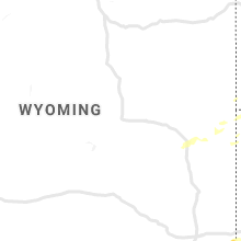
Wyoming
| Local Time | Report Details |
|---|---|
| 5:30 PM MDT | Storm damage reported in campbell county WY, 36.5 miles NNW of Gillette, WY |
| 5:40 PM MDT | Quarter sized hail reported near Recluse, WY, 41.9 miles N of Gillette, WY |
Kansas
| Local Time | Report Details |
|---|---|
| 7:16 PM CDT | Quarter sized hail reported near Vermillion, KS, 44.3 miles NNE of Manhattan, KS |
| 7:20 PM CDT | Golf Ball sized hail reported near Vermillion, KS, 44.3 miles NNE of Manhattan, KS |
| 11:23 PM CDT | Norton county dispatch reports numerous tree down around the town of norto in norton county KS, 69.1 miles ENE of Colby, KS |
| 12:00 AM CDT | Storm damage reported in phillips county KS, 56 miles NNW of Hays, KS |
| 5:52 AM CDT | Storm damage reported in jewell county KS, 72.1 miles S of Grand Island, NE |
| 6:14 AM CDT | Storm damage reported in republic county KS, 80.9 miles SSE of Grand Island, NE |
| 6:18 AM CDT | Storm damage reported in douglas county KS, 34.9 miles W of Kansas City, MO |
Iowa
| Local Time | Report Details |
|---|---|
| 3:30 AM CDT | Quarter sized hail reported near Whiting, IA, 60.3 miles SW of Storm Lake, IA |
Connect with Interactive Hail Maps