

Hail Map for Friday, June 22, 2018

Number of Impacted Households on 6/22/2018
0
Impacted by 1" or Larger Hail
0
Impacted by 1.75" or Larger Hail
0
Impacted by 2.5" or Larger Hail
Square Miles of Populated Area Impacted on 6/22/2018
0
Impacted by 1" or Larger Hail
0
Impacted by 1.75" or Larger Hail
0
Impacted by 2.5" or Larger Hail


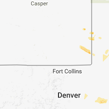


Cities Most Affected by Hail Storms of 6/22/2018
| Hail Size | Demographics of Zip Codes Affected | ||||||
|---|---|---|---|---|---|---|---|
| City | Count | Average | Largest | Pop Density | House Value | Income | Age |
| Rapid City, SD | 2 | 1.75 | 1.75 | 111 | $119k | $47.4k | 44.3 |
| Panhandle, TX | 2 | 1.75 | 1.75 | 1 | $58k | $41.5k | 39.8 |
| Hermosa, SD | 1 | 2.00 | 2.00 | 3 | $127k | $35.4k | 44.4 |
| Stratford, TX | 1 | 1.75 | 1.75 | 0 | $47k | $32.3k | 36.3 |
| Mclean, TX | 1 | 1.75 | 1.75 | 1 | $25k | $26.7k | 46.1 |
| Sheridan Lake, CO | 1 | 1.75 | 1.75 | 1 | $25k | $30.7k | 38.8 |
| Dalton, NE | 1 | 1.75 | 1.75 | 2 | $44k | $28.8k | 45.8 |
| Folsom, NM | 1 | 1.75 | 1.75 | 0 | $53k | $13.8k | 47.5 |
| Goodwell, OK | 1 | 1.75 | 1.75 | 1 | $73k | $34.1k | 22.8 |
| Hooker, OK | 1 | 1.75 | 1.75 | 3 | $62k | $36.1k | 32.9 |
Hail and Wind Damage Spotted on 6/22/2018
Filter by Report Type:Hail ReportsWind Reports
States Impacted
Arkansas, Mississippi, Louisiana, Georgia, Oklahoma, Alabama, Tennessee, South Dakota, Virginia, Colorado, Kansas, Kentucky, Nebraska, West Virginia, Washington, Ohio, New Mexico, Texas, Florida, South Carolina, WyomingArkansas
| Local Time | Report Details |
|---|---|
| 7:48 AM CDT | Tree down on power lines in the 300 block of missouri s in ashley county AR, 24.4 miles N of Bastrop, LA |
| 8:40 AM CDT | Law enforcement reports trees down in bradley county AR, 40.8 miles NNW of Bastrop, LA |
| 9:43 AM CDT | Tree limbs were blown down in hutti in union county AR, 23.7 miles NW of Bastrop, LA |
| 9:45 AM CDT | Corrects previous tstm wnd dmg report from 1 e felsenthal. four power poles were broken near the felsenthal lock and dam. power is out between the felsenthal community in union county AR, 23.1 miles NNW of Bastrop, LA |
| 9:59 AM CDT | Tree down just east of wilmo in ashley county AR, 28.8 miles NE of Bastrop, LA |
| 1:34 PM CDT | Trees reported to be blown dow in drew county AR, 59.8 miles N of Bastrop, LA |
| 4:05 AM CDT | Trees down around mt. ida. one road blocked due to downed large tree. some power outage in montgomery county AR, 43.3 miles NNE of Nashville, AR |
| 5:40 AM CDT | A tree was blown down across john shelton road between long lane and monkey lan in lonoke county AR, 14.5 miles ENE of Little Rock, AR |
| 5:49 AM CDT | A large tree was blown down across highway 31 sout in lonoke county AR, 21.3 miles E of Little Rock, AR |
Mississippi
| Local Time | Report Details |
|---|---|
| 8:50 AM CDT | Tree limbs down 6 miles northeast of tutwile in tallahatchie county MS, 76.5 miles SSW of Memphis, TN |
| 8:50 AM CDT | Tree limbs dow in tallahatchie county MS, 78.4 miles SSW of Memphis, TN |
| 4:55 PM CDT | Tree down on a power line. time estimate in issaquena county MS, 49.3 miles E of Bastrop, LA |
| 5:25 PM CDT | Tree down on power line which then caught on fir in madison county MS, 9.8 miles N of Jackson, MS |
| 6:50 PM CDT | Gas station sign blown down onto an automobil in jasper county MS, 73.7 miles ESE of Jackson, MS |
| 6:50 PM CDT | Several trees down across country roads around rose hil in jasper county MS, 70 miles E of Jackson, MS |
| 6:55 PM CDT | Tree blocking county road 280 just east of highway 1 in clarke county MS, 78.1 miles ESE of Jackson, MS |
| 7:15 PM CDT | Report of large tree down on county road 690 east of highway 14 in clarke county MS, 83.4 miles W of Camden, AL |
Louisiana
| Local Time | Report Details |
|---|---|
| 10:24 AM CDT | Several trees were blown down along louisiana 140... to the north of log cabi in morehouse county LA, 5 miles NNE of Bastrop, LA |
| 10:25 AM CDT | Tree down on a power line just north of kilbourn in west carroll county LA, 38.4 miles ENE of Bastrop, LA |
| 10:30 AM CDT | Tree down on a house located on herlong d in morehouse county LA, 5.9 miles NNE of Bastrop, LA |
Georgia
| Local Time | Report Details |
|---|---|
| 12:36 PM EDT | Report of a tree down on old quitman hwy south of hwy 8 in lowndes county GA, 58.2 miles SSW of Douglas, GA |
| 12:48 PM EDT | Tree reported down on a power line near the 1600 block of n. paterson s in lowndes county GA, 52.2 miles SSW of Douglas, GA |
| 5:15 PM EDT | Wires were reported down across the roadway on wiley bridge road off pioneer circl in cherokee county GA, 23.8 miles N of Atlanta, GA |
| 5:15 PM EDT | A tree was blown down on cogburn rd near the intersection of windward parkwa in fulton county GA, 25.1 miles NNE of Atlanta, GA |
| 5:19 PM EDT | A tree was blown down on freemanville road just south of birmingham roa in fulton county GA, 28.7 miles N of Atlanta, GA |
| 5:22 PM EDT | A tree and power lines were reported down on post road at derby trai in forsyth county GA, 29.7 miles NNE of Atlanta, GA |
| 5:22 PM EDT | Forsyth county sheriffs office reports a tree was blown down on valley stream driv in forsyth county GA, 30.2 miles NNE of Atlanta, GA |
| 5:24 PM EDT | A tree was blown down on majors road near the intersection of castleberry roa in forsyth county GA, 30.9 miles NNE of Atlanta, GA |
| 5:36 PM EDT | A tree was blown down onto i-20 westbound about 2 miles west of lee roa in douglas county GA, 17.2 miles W of Atlanta, GA |
| 5:37 PM EDT | A tree was blown down on hammett rd at johnson r in troup county GA, 49.2 miles SW of Atlanta, GA |
| 5:41 PM EDT | A tree was blown down on a.t. moore rd at kelly bridge r in dawson county GA, 42.8 miles NNE of Atlanta, GA |
| 5:50 PM EDT | A tree was blown down on sweetgum driv in dawson county GA, 47 miles NNE of Atlanta, GA |
| 5:50 PM EDT | A tree was blown down on brights way at highway 5 in dawson county GA, 47.7 miles NNE of Atlanta, GA |
| 5:50 PM EDT | A tree was blown down on clayton wallace r in dawson county GA, 47.5 miles NNE of Atlanta, GA |
| 5:56 PM EDT | A tree was blown down on highway 166 at big a roa in douglas county GA, 23.8 miles WSW of Atlanta, GA |
| 6:16 PM EDT | Multiple trees and power lines were downed on roanoke rd just west of vernon stree in troup county GA, 37.7 miles NE of Auburn, AL |
| 6:17 PM EDT | A tree was blown down on troup street near lukken industrial driv in troup county GA, 37.4 miles NE of Auburn, AL |
| 6:35 PM EDT | A tree was blown down onto antioch roa in heard county GA, 53.6 miles WSW of Atlanta, GA |
| 6:37 PM EDT | A tree was blown down on hammett rd at johnson r in troup county GA, 49.2 miles SW of Atlanta, GA |
| 6:40 PM EDT | A tree and power lines were downed on highway 100 nort in heard county GA, 51.9 miles NNE of Auburn, AL |
| 6:48 PM EDT | A tree was blown down on cherry roa in heard county GA, 47.7 miles SW of Atlanta, GA |
| 6:48 PM EDT | A tree and power lines were downed on lwry rd near highway 2 in coweta county GA, 42.2 miles SW of Atlanta, GA |
| 6:55 PM EDT | A tree was blown down on highway 29 at alex stephens roa in coweta county GA, 37.3 miles SW of Atlanta, GA |
| 7:00 PM EDT | Two trees were blown down on welcome roa in coweta county GA, 37.1 miles SW of Atlanta, GA |
| 7:02 PM EDT | A tree was blown down on witcher rd near highway 1 in coweta county GA, 34.8 miles SW of Atlanta, GA |
| 7:03 PM EDT | A tree was blown down on green top rd near highway 2 in coweta county GA, 31.5 miles SW of Atlanta, GA |
| 7:10 PM EDT | A tree was blown down on power lines on kelly driv in fayette county GA, 27.6 miles SSW of Atlanta, GA |
| 7:11 PM EDT | Trees are blocking south peachtree parkway at battery wa in fayette county GA, 26.1 miles SSW of Atlanta, GA |
| 7:11 PM EDT | A large tree fell onto south peachtree parkway at crosstown driv in fayette county GA, 27.2 miles SSW of Atlanta, GA |
| 7:11 PM EDT | A tree was blown down on lafayette court near andrew bailey roa in coweta county GA, 27.7 miles SSW of Atlanta, GA |
| 7:12 PM EDT | A tree was blown down on andrew bailey road near fisher roa in coweta county GA, 26.5 miles SW of Atlanta, GA |
| 7:35 PM EDT | One tree down near malier road and 41 in spalding county GA, 27.9 miles S of Atlanta, GA |
| 7:38 PM EDT | Multiple trees down concentrated between the atlanta motor speedway/hampton to mcdonough. additional trees down in stockbridg in henry county GA, 25.5 miles SSE of Atlanta, GA |
| 8:10 PM EDT | A tree and power lines were downed at dupree drive and laney driv in muscogee county GA, 36.2 miles ESE of Auburn, AL |
| 8:10 PM EDT | A tree was downed at the intersection of hilton avenue and 17th stree in muscogee county GA, 32.3 miles ESE of Auburn, AL |
| 8:12 PM EDT | Multiple trees down across the count in muscogee county GA, 30.4 miles ESE of Auburn, AL |
| 9:12 PM EDT | A tree was blown down on golf course driv in taylor county GA, 81.2 miles E of Auburn, AL |
| 9:12 PM EDT | A tree was blown down at robert highway and wainwright cemetery roa in taylor county GA, 75.9 miles E of Auburn, AL |
| 9:30 PM EDT | A tree was downed onto power lines on magnolia stree in peach county GA, 86.2 miles SSE of Atlanta, GA |
Oklahoma
| Local Time | Report Details |
|---|---|
| 11:53 AM CDT | Storm damage reported in washita county OK, 76.9 miles S of Woodward, OK |
| 11:55 AM CDT | Storm damage reported in cotton county OK, 34.3 miles NNE of Wichita Falls, TX |
| 5:01 PM CDT | Half Dollar sized hail reported near Boise City, OK, 113.6 miles NNW of Amarillo, TX, trained spotter reports half dollar sized hail. |
| 5:34 PM CDT | Quarter sized hail reported near Keyes, OK, 104.1 miles SW of Garden City, KS |
| 6:09 PM CDT | Storm damage reported in sherman county TX, 77.4 miles N of Amarillo, TX |
| 6:47 PM CDT | Golf Ball sized hail reported near Hooker, OK, 86.9 miles S of Garden City, KS |
| 6:47 PM CDT | Golf Ball sized hail reported near Goodwell, OK, 100.4 miles SSW of Garden City, KS |
| 7:15 PM CDT | Storm damage reported in beaver county OK, 67.8 miles WNW of Woodward, OK |
| 7:20 PM CDT | Storm damage reported in beaver county OK, 67.8 miles WNW of Woodward, OK |
| 7:45 PM CDT | Storm damage reported in beaver county OK, 49.3 miles WNW of Woodward, OK |
| 8:25 PM CDT | Power lines down and tree damage reported near the woodward airpor in woodward county OK, 6.8 miles W of Woodward, OK |
| 8:30 PM CDT | Storm damage reported in woodward county OK, 0.3 miles SSW of Woodward, OK |
| 8:30 PM CDT | 85 foot tree reported dow in woodward county OK, 0.4 miles N of Woodward, OK |
| 8:45 PM CDT | Storm damage reported in woodward county OK, 11.1 miles E of Woodward, OK |
| 8:55 PM CDT | Storm damage reported in woods county OK, 38.5 miles ENE of Woodward, OK |
| 9:00 PM CDT | Tree branches down and shed blown ove in major county OK, 30.5 miles ESE of Woodward, OK |
| 9:00 PM CDT | Corrects previous tstm wnd dmg report from seiling. roof blown off a house with an outbuilding blown into a separate house. windows also broken in seilin in dewey county OK, 32.7 miles SE of Woodward, OK |
| 9:10 PM CDT | Storm damage reported in alfalfa county OK, 62.3 miles ENE of Woodward, OK |
| 9:13 PM CDT | Storm damage reported in woodward county OK, 27 miles SE of Woodward, OK |
| 9:30 PM CDT | Storm damage reported in dewey county OK, 43.9 miles SSE of Woodward, OK |
| 9:50 PM CDT | Storm damage reported in major county OK, 44.3 miles ESE of Woodward, OK |
| 9:53 PM CDT | Roof blown off a house with an outbuilding blown into a separate house. windows also broken in seilin in dewey county OK, 32.7 miles SE of Woodward, OK |
| 9:55 PM CDT | Storm damage reported in custer county OK, 69.9 miles W of Oklahoma City, OK |
| 10:00 PM CDT | Storm damage reported in kay county OK, 52.9 miles S of Wichita, KS |
| 10:01 PM CDT | Storm damage reported in garfield county OK, 64.4 miles NNW of Oklahoma City, OK |
| 10:19 PM CDT | Storm damage reported in kingfisher county OK, 31.3 miles NW of Oklahoma City, OK |
| 10:20 PM CDT | Storm damage reported in logan county OK, 43.5 miles N of Oklahoma City, OK |
| 10:30 PM CDT | Storm damage reported in canadian county OK, 27.1 miles W of Oklahoma City, OK |
| 10:40 PM CDT | Several large tree limbs dow in oklahoma county OK, 9.9 miles NW of Oklahoma City, OK |
| 10:45 PM CDT | Storm damage reported in canadian county OK, 12.8 miles WNW of Oklahoma City, OK |
| 10:45 PM CDT | Several large tree branches dow in oklahoma county OK, 13.2 miles N of Oklahoma City, OK |
| 10:50 PM CDT | Storm damage reported in grady county OK, 26.4 miles WSW of Oklahoma City, OK |
| 10:53 PM CDT | Storm damage reported in oklahoma county OK, 8.3 miles WNW of Oklahoma City, OK |
| 10:55 PM CDT | Storm damage reported in mcclain county OK, 17 miles SSW of Oklahoma City, OK |
| 10:55 PM CDT | Storm damage reported in grady county OK, 27.3 miles WSW of Oklahoma City, OK |
| 11:00 PM CDT | Storm damage reported in oklahoma county OK, 8.3 miles WNW of Oklahoma City, OK |
| 11:01 PM CDT | Media reports of multiple semi-trucks blown over on i-40 west of el ren in canadian county OK, 29.6 miles W of Oklahoma City, OK |
| 11:04 PM CDT | Storm damage reported in oklahoma county OK, 7.2 miles SW of Oklahoma City, OK |
| 11:06 PM CDT | Storm damage reported in grady county OK, 38 miles SW of Oklahoma City, OK |
| 11:07 PM CDT | Storm damage reported in oklahoma county OK, 8.2 miles ESE of Oklahoma City, OK |
| 11:10 PM CDT | Storm damage reported in cleveland county OK, 12.1 miles S of Oklahoma City, OK |
| 11:15 PM CDT | Storm damage reported in cleveland county OK, 16.2 miles S of Oklahoma City, OK |
| 11:15 PM CDT | Storm damage reported in cleveland county OK, 16.2 miles S of Oklahoma City, OK |
| 11:30 PM CDT | Storm damage reported in comanche county OK, 46.4 miles N of Wichita Falls, TX |
| 11:30 PM CDT | Storm damage reported in comanche county OK, 47.9 miles N of Wichita Falls, TX |
| 11:38 PM CDT | Half Dollar sized hail reported near Willow, OK, 58.5 miles NE of Childress, TX |
| 11:45 PM CDT | Quarter sized hail reported near Norman, OK, 24.5 miles SE of Oklahoma City, OK |
| 12:30 AM CDT | Storm damage reported in pontotoc county OK, 41.1 miles NW of Atoka, OK |
| 1:00 AM CDT | Multiple large trees down blocking roadways in alle in pontotoc county OK, 37.7 miles NNW of Atoka, OK |
Alabama
| Local Time | Report Details |
|---|---|
| 11:55 AM CDT | Small greenhouse overturned and few branches reported down by estimated 40-50 mph wind in lamar county AL, 45.3 miles ENE of Starkville, MS |
| 12:37 PM CDT | Tree down at the corner of bridges and jennings chapel rds. time estimated from rada in limestone county AL, 48.9 miles E of Florence, AL |
| 1:02 PM CDT | Power lines down near the corner of carriger rd. and boles rd. time estimated from rada in madison county AL, 65.4 miles E of Florence, AL |
| 1:07 PM CDT | Trees and power poles down along walt campbell road. time estimated from rada in madison county AL, 65.9 miles E of Florence, AL |
| 1:31 PM CDT | Trees down on county road 175 near estillfork. tree down on a house on county road 140 in the same area. time estimated from rada in jackson county AL, 49 miles W of Chattanooga, TN |
| 2:48 PM CDT | Multiple trees down on residential driveways. winds estimated 40-50 mph per radar. 26 mph gust measured at eo in cherokee county AL, 69.5 miles SSW of Chattanooga, TN |
| 2:55 PM CDT | Tree and powerlines blocking road at highway 9 and county road 18. winds estimated 30-40 mph with 26 mph measured at eo in cherokee county AL, 72.3 miles SSW of Chattanooga, TN |
| 3:36 PM CDT | A few trees down... at least one vehicle damaged near uab campus in birmingham. time estimated by rada in jefferson county AL, 1.5 miles SSW of Birmingham, AL |
| 3:41 PM CDT | Tree down on roadway at greenwood road and gammils store road. wind estimated 40-50 mph per rada in tallapoosa county AL, 21.7 miles W of Auburn, AL |
| 4:48 PM CDT | Trees down on dudleyville road and mckelvey stree in tallapoosa county AL, 23.7 miles NW of Auburn, AL |
| 4:48 PM CDT | Tree down at eagle creek road and crouch roa in tallapoosa county AL, 26.1 miles NW of Auburn, AL |
| 4:48 PM CDT | Several trees blown down across highway near intersection of cr 33 and us 7 in lauderdale county AL, 13.4 miles ENE of Florence, AL |
| 4:53 PM CDT | Trees reported down in the elgin are in lauderdale county AL, 16.6 miles ENE of Florence, AL |
| 5:00 PM CDT | 911 dispatch center reports multiple power lines down in various areas. time estimated by rada in chambers county AL, 24.3 miles N of Auburn, AL |
| 5:04 PM CDT | Quarter sized hail reported near Wetumpka, AL, 39 miles W of Auburn, AL, reported along dexter road near santuck. |
| 6:44 PM CDT | Tin rolled back on a couple outbuildings and carport lifted at two locations along county road 85. possible tornad in winston county AL, 49.1 miles SE of Florence, AL |
| 6:58 PM CDT | Tree down on lee road 17 in lee county AL, 19.4 miles ESE of Auburn, AL |
| 7:53 PM CDT | Large tree blocking britton lige roa in washington county AL, 70.2 miles WSW of Camden, AL |
| 7:59 PM CDT | Trees down on power lines on nathan jordan roa in washington county AL, 65.5 miles NNW of Mobile, AL |
Tennessee
| Local Time | Report Details |
|---|---|
| 12:45 PM CDT | A couple trees down in and around town along with a fireworks tent blown over in coffee county TN, 52.4 miles NW of Chattanooga, TN |
| 12:46 PM CDT | 40-50 trees down along shoal creek road west of the community of leoma. 4 homes damaged from these tree in lawrence county TN, 32.9 miles NE of Florence, AL |
| 1:05 PM CDT | Tree down in cornersville in marshall county TN, 55.8 miles S of Nashville, TN |
| 1:25 PM CDT | Trees down on gaither r in bedford county TN, 50.2 miles SSE of Nashville, TN |
| 1:45 PM CDT | A couple trees down in and around town along with a fireworks tent blown over in coffee county TN, 52.4 miles NW of Chattanooga, TN |
| 1:45 PM CDT | Large limbs broken off several trees on the south end of manchester in coffee county TN, 51.7 miles WNW of Chattanooga, TN |
| 2:25 PM CDT | Four trees down on highway 134 near the dade/marion county lin in marion county TN, 18.8 miles W of Chattanooga, TN |
South Dakota
| Local Time | Report Details |
|---|---|
| 12:48 PM MDT | Ping Pong Ball sized hail reported near Rapid City, SD, 17.3 miles WNW of Rapid City, SD, hail near the size of ping pong balls |
| 1:13 PM MDT | Quarter sized hail reported near Rapid City, SD, 9 miles W of Rapid City, SD, mping report |
| 1:15 PM MDT | Half Dollar sized hail reported near Rapid City, SD, 9 miles W of Rapid City, SD, mping report |
| 1:15 PM MDT | Golf Ball sized hail reported near Rapid City, SD, 8.4 miles W of Rapid City, SD |
| 1:16 PM MDT | Golf Ball sized hail reported near Rapid City, SD, 8.5 miles W of Rapid City, SD |
| 1:32 PM MDT | Quarter sized hail reported near Rapid City, SD, 2.1 miles SW of Rapid City, SD |
| 1:34 PM MDT | Half Dollar sized hail reported near Rapid City, SD, 6 miles SW of Rapid City, SD |
| 1:34 PM MDT | Quarter sized hail reported near Rapid City, SD, 1.7 miles SSW of Rapid City, SD, at least quarter sized hail |
| 1:37 PM MDT | Half Dollar sized hail reported near Rapid City, SD, 5.1 miles SW of Rapid City, SD, mping report |
| 1:40 PM MDT | Ping Pong Ball sized hail reported near Rapid City, SD, 5.7 miles SSW of Rapid City, SD, image shows hail between half dollar and ping pong ball sized |
| 1:49 PM MDT | Half Dollar sized hail reported near Rapid City, SD, 4.2 miles S of Rapid City, SD |
| 1:51 PM MDT | Half Dollar sized hail reported near Rapid City, SD, 1.9 miles NW of Rapid City, SD |
| 2:28 PM MDT | Ping Pong Ball sized hail reported near Rapid City, SD, 11.9 miles S of Rapid City, SD |
| 3:15 PM MDT | Hen Egg sized hail reported near Hermosa, SD, 20.8 miles SSE of Rapid City, SD, via mping |
| 3:45 PM MDT | Quarter sized hail reported near Hermosa, SD, 25.5 miles SSE of Rapid City, SD |
| 3:55 PM MDT | Quarter sized hail reported near Reva, SD, 103 miles N of Rapid City, SD |
| 4:55 PM MDT | Half Dollar sized hail reported near Kyle, SD, 72.4 miles ESE of Rapid City, SD, reported along bia hwy 2 |
| 5:30 PM MDT | Several vehicles blown off the road at the intersection of sd hwy 44 and bia in jackson county SD, 76 miles ESE of Rapid City, SD |
| 6:20 PM MDT | Quarter sized hail reported near Martin, SD, 58.6 miles WNW of Valentine, NE, a lot of quarter sized hail |
| 6:28 PM MDT | Quarter sized hail reported near Martin, SD, 56.4 miles WNW of Valentine, NE, via mping |
Virginia
| Local Time | Report Details |
|---|---|
| 3:16 PM EDT | One tree blown down by thunderstorm winds along butt hollow road in city of salem county VA, 9.4 miles W of Roanoke, VA |
| 3:22 PM EDT | One power line blown down by thunderstorm winds along shirley road in roanoke county VA, 8.5 miles WNW of Roanoke, VA |
| 3:30 PM EDT | Large limbed snapped on tree off tennessee stree in city of salem county VA, 6.1 miles W of Roanoke, VA |
| 3:46 PM EDT | One tree blown down on a house along independence circle in campbell county VA, 37.2 miles E of Roanoke, VA |
| 3:51 PM EDT | One tree blown down near the intersection of dickerson mill road and saunders grove drive in bedford county VA, 14.4 miles E of Roanoke, VA |
| 3:52 PM EDT | One tree blown down by thunderstorm winds near the intersection of shadwell drive and hawkins mill road in bedford county VA, 38.7 miles ENE of Roanoke, VA |
| 4:19 PM EDT | One tree blown down by thunderstorm winds near the intersection of cabin field road and stage road in campbell county VA, 49.7 miles E of Roanoke, VA |
| 5:15 PM EDT | Several trees blown down by thunderstorm winds in keysville in charlotte county VA, 55.7 miles SW of Richmond, VA |
| 5:24 PM EDT | One tree down along highway 1 in charlotte county VA, 54.2 miles WSW of Richmond, VA |
| 5:25 PM EDT | Trees down in bracey near highway 903 and hicks r in mecklenburg county VA, 62.5 miles NNE of Raleigh, NC |
| 5:27 PM EDT | Trees down along ridout r in mecklenburg county VA, 63.3 miles NNE of Raleigh, NC |
| 5:31 PM EDT | Oak tree down on cabbage patch roa in prince edward county VA, 52.9 miles WSW of Richmond, VA |
| 5:57 PM EDT | Quarter sized hail reported near Gasburg, VA, 65.3 miles SSW of Richmond, VA |
| 6:40 PM EDT | Trees down at exit 12 near i9 in greensville county VA, 53.8 miles S of Richmond, VA |
| 6:40 PM EDT | Trees down near exit 12 at i9 in greensville county VA, 53.8 miles S of Richmond, VA |
| 7:12 PM EDT | Several trees down near yal in sussex county VA, 48.7 miles SSE of Richmond, VA |
| 7:30 PM EDT | Trees down north of capron near the sussex county lin in southampton county VA, 56.4 miles SSE of Richmond, VA |
| 8:00 PM EDT | Trees down at va-620 and tings r in isle of wight county VA, 39.8 miles WNW of Virginia Beach, VA |
| 8:11 PM EDT | One tree down near entrance to lake mooma in alleghany county VA, 44.8 miles N of Roanoke, VA |
| 8:20 PM EDT | One power line blown down along clarkton road in halifax county VA, 59.1 miles ESE of Roanoke, VA |
| 8:30 PM EDT | One tree blown down near the intersection of mortons ferry road and hardings mill road in halifax county VA, 65.7 miles ESE of Roanoke, VA |
| 8:35 PM EDT | Trees downed along us-17 in carollton. report from local broadcast media social media pag in isle of wight county VA, 29 miles WNW of Virginia Beach, VA |
| 8:40 PM EDT | 90 foot pine tree down in yard. time estimated by rada in city of suffolk county VA, 26.7 miles WNW of Virginia Beach, VA |
| 8:44 PM EDT | One tree blown down by thunderstorm winds in clover in halifax county VA, 72.2 miles N of Raleigh, NC |
| 9:00 PM EDT | Tree uprooted at mcguire lane near wylliesbur in charlotte county VA, 69.1 miles SW of Richmond, VA |
| 9:25 PM EDT | Mesonet station xbbt... third islan in anz632 county VA, 19.7 miles N of Virginia Beach, VA |
Colorado
| Local Time | Report Details |
|---|---|
| 1:50 PM MDT | Quarter sized hail reported near Bethune, CO, 50 miles SSE of Yuma, CO, twitter report. |
| 3:10 PM MDT | Winds gusting to atleast 60 mph. also had pea size hai in cheyenne county CO, 84.4 miles WSW of Colby, KS |
| 3:12 PM MDT | Mesonet station co068... firstvie in cheyenne county CO, 89.7 miles WSW of Colby, KS |
| 3:25 PM MDT | Estimated 60-70 mph wind gusts accompanied with pea to nickel size hail and torrential rainfal in cheyenne county CO, 71.3 miles WSW of Colby, KS |
| 4:08 PM MDT | Golf Ball sized hail reported near Sheridan Lake, CO, 81.5 miles WNW of Garden City, KS |
| 4:30 PM MDT | Ping Pong Ball sized hail reported near Holly, CO, 68.2 miles W of Garden City, KS |
| 4:33 PM MDT | Quarter sized hail reported near Springfield, CO, 103.2 miles WSW of Garden City, KS |
Kansas
| Local Time | Report Details |
|---|---|
| 3:02 PM CDT | Delayed report. one 8 inch branch broken. relayed via social medi in cheyenne county KS, 44.9 miles ESE of Yuma, CO |
| 2:17 PM MDT | Storm damage reported in sherman county KS, 39.5 miles W of Colby, KS |
| 2:25 PM MDT | Estimated winds of 65 mph. visibility less than 1 mile associated with blowing dus in sherman county KS, 35.7 miles W of Colby, KS |
| 2:27 PM MDT | Nws goodland measured northwest winds sustained at 48 mph with gusts to 69 mp in sherman county KS, 35.1 miles W of Colby, KS |
| 3:32 PM CDT | Bird city airpor in cheyenne county KS, 35.1 miles NW of Colby, KS |
| 3:55 PM CDT | Mesonet site measured a 63 mph wind gus in thomas county KS, 17.8 miles WNW of Colby, KS |
| 3:58 PM CDT | Storm damage reported in rawlins county KS, 32.2 miles NNW of Colby, KS |
| 4:10 PM CDT | Mesonet station k5adt... 2 ese beardsle in rawlins county KS, 27.5 miles NNW of Colby, KS |
| 4:20 PM CDT | Storm damage reported in thomas county KS, 11.2 miles SSW of Colby, KS |
| 4:20 PM CDT | Power line down in association with severe wind just north of atwoo in rawlins county KS, 34.2 miles N of Colby, KS |
| 4:30 PM CDT | Estimated gust of 60-65 mph. blew off a few shingles from the roof of the hous in rawlins county KS, 33.6 miles N of Colby, KS |
| 4:53 PM CDT | Winds estimated at 65 mph. pea to dime size hail also observe in gove county KS, 29.3 miles SE of Colby, KS |
| 5:02 PM CDT | Facebook report - unknown wind speed...1/2 branches broken from tree in gove county KS, 36.7 miles ESE of Colby, KS |
| 5:02 PM CDT | Storm damage reported in sheridan county KS, 32 miles E of Colby, KS |
| 5:50 PM CDT | Storm damage reported in scott county KS, 37.1 miles NNE of Garden City, KS |
| 6:24 PM CDT | Storm damage reported in finney county KS, 8.8 miles ESE of Garden City, KS |
| 7:00 PM CDT | Storm damage reported in seward county KS, 53.9 miles S of Garden City, KS |
| 7:00 PM CDT | Tree damage reported via social medi in ford county KS, 48.8 miles ESE of Garden City, KS |
| 7:02 PM CDT | Measured at the dodge city airpor in ford county KS, 51.4 miles ESE of Garden City, KS |
| 7:52 PM CDT | Storm damage reported in pratt county KS, 85.9 miles W of Wichita, KS |
| 7:54 PM CDT | Storm damage reported in pratt county KS, 84.4 miles W of Wichita, KS |
| 8:02 PM CDT | Storm damage reported in pratt county KS, 81.5 miles NNE of Woodward, OK |
| 8:25 PM CDT | Storm damage reported in woods county OK, 44.9 miles NNE of Woodward, OK |
| 8:38 PM CDT | Storm damage reported in barber county KS, 73.7 miles WSW of Wichita, KS |
| 8:45 PM CDT | Storm damage reported in kingman county KS, 61.2 miles WSW of Wichita, KS |
| 9:08 PM CDT | Storm damage reported in seward county KS, 64.2 miles S of Garden City, KS |
Kentucky
| Local Time | Report Details |
|---|---|
| 4:20 PM EDT | Shed was damaged from winds near the jackson in in breathitt county KY, 34 miles ESE of Irvine, KY |
| 4:22 PM EDT | Several trees down along ky-30e. time estimated from rada in breathitt county KY, 37 miles ESE of Irvine, KY |
| 6:10 PM EDT | A couple of trees were reported to have been blown down in the turkey creek and south willliamson ky 292 are in pike county KY, 59.4 miles SW of Charleston, WV |
Nebraska
| Local Time | Report Details |
|---|---|
| 2:49 PM MDT | Golf Ball sized hail reported near Dalton, NE, 43.9 miles SE of Scottsbluff, NE, facebook report and picture of 1.75 hail from spotter dan fitts. |
West Virginia
| Local Time | Report Details |
|---|---|
| 5:19 PM EDT | One tree blown down near the intersection of old oakvale road and north greenview drive in mercer county WV, 61.5 miles W of Roanoke, VA |
| 5:59 PM EDT | Multiple trees blown down by thunderstorm winds along fairway drive in summers county WV, 59.8 miles WNW of Roanoke, VA |
| 6:18 PM EDT | One tree blown down along mill creek road in summers county WV, 56.8 miles SE of Charleston, WV |
| 6:35 PM EDT | One tree blown down near the intersection of muddy creek mountain road and low gap road in greenbrier county WV, 48.8 miles NW of Roanoke, VA |
| 6:46 PM EDT | One tree blown down by thunderstorm winds along delaney street in greenbrier county WV, 44 miles NW of Roanoke, VA |
| 6:46 PM EDT | One tree blown down by thunderstorm winds along morgan drive in greenbrier county WV, 43.1 miles NW of Roanoke, VA |
| 6:51 PM EDT | One tree blown down by thunderstorm winds near the intersection of east washington street and holt lane in greenbrier county WV, 45.6 miles NW of Roanoke, VA |
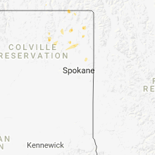
Washington
| Local Time | Report Details |
|---|---|
| 2:23 PM PDT | Quarter sized hail reported near Colville, WA, 67.5 miles NNW of Spokane, WA, timing of report was estimated off of radar. |
Ohio
| Local Time | Report Details |
|---|---|
| 6:00 PM EDT | Large tree down on state route 309 west of state route 9 in marion county OH, 43.2 miles N of Columbus, OH |
New Mexico
| Local Time | Report Details |
|---|---|
| 4:22 PM MDT | Golf Ball sized hail reported near Folsom, NM, 105.2 miles SSE of Pueblo, CO |
| 5:31 PM MDT | Kcvs aso in curry county NM, 59.3 miles SSE of Tucumcari, NM |
| 6:15 PM MDT | Power lines down on north side of clovi in curry county NM, 58.4 miles SSE of Tucumcari, NM |
Texas
| Local Time | Report Details |
|---|---|
| 5:39 PM CDT | Tractor trailers blown off the road 5 miles n of hartley on us-8 in hartley county TX, 60.9 miles NNW of Amarillo, TX |
| 5:42 PM CDT | Golf Ball sized hail reported near Stratford, TX, 68.2 miles NNW of Amarillo, TX |
| 6:05 PM CDT | Quarter sized hail reported near Boys Ranch, TX, 31.4 miles NW of Amarillo, TX |
| 6:07 PM CDT | Storm damage reported in potter county TX, 15.6 miles NNW of Amarillo, TX |
| 6:21 PM CDT | Quarter sized hail reported near Stratford, TX, 64.4 miles N of Amarillo, TX, spotter also reported very heavy rain. |
| 6:23 PM CDT | Storm damage reported in potter county TX, 15.6 miles NNW of Amarillo, TX |
| 6:44 PM CDT | Storm damage reported in hansford county TX, 62.3 miles NNE of Amarillo, TX |
| 7:20 PM CDT | West texas mesonet repor in parmer county TX, 61.9 miles SW of Amarillo, TX |
| 7:45 PM CDT | Golf Ball sized hail reported near Panhandle, TX, 25.4 miles ENE of Amarillo, TX |
| 7:52 PM CDT | Golf Ball sized hail reported near Panhandle, TX, 27 miles ENE of Amarillo, TX |
| 7:58 PM CDT | Quarter sized hail reported near Panhandle, TX, 28 miles ENE of Amarillo, TX |
| 8:13 PM CDT | Storm damage reported in hemphill county TX, 60.7 miles SW of Woodward, OK |
| 8:18 PM CDT | Quarter sized hail reported near Muleshoe, TX, 75.2 miles NW of Lubbock, TX |
| 8:27 PM CDT | Powerlines are down with the 60 mph wind in carson county TX, 40 miles ENE of Amarillo, TX |
| 8:29 PM CDT | Inflow to thunderstor in hutchinson county TX, 51.2 miles NNE of Amarillo, TX |
| 8:35 PM CDT | Storm damage reported in hutchinson county TX, 48.7 miles NNE of Amarillo, TX |
| 9:09 PM CDT | Strongly rotating wall cloud with mini funnels and 70 mph wind gust in carson county TX, 45.1 miles NE of Amarillo, TX |
| 9:17 PM CDT | Golf Ball sized hail reported near Mclean, TX, 55 miles NNW of Childress, TX |
| 9:30 PM CDT | Reports of multiple down trees and powerlines... power out through half the city... and emergency manager continues to assess wind damag in gray county TX, 54.7 miles ENE of Amarillo, TX |
| 9:30 PM CDT | Powerlines downe in gray county TX, 53.7 miles ENE of Amarillo, TX |
| 9:35 PM CDT | Trees blown over... outbuildings destroyed and irrigation systems blown over near intersection of fm 282 and fm 2391 in roberts county TX, 63.1 miles ENE of Amarillo, TX |
| 9:35 PM CDT | Storm damage reported in gray county TX, 56 miles ENE of Amarillo, TX |
| 9:35 PM CDT | Storm damage reported in gray county TX, 54.6 miles ENE of Amarillo, TX |
| 9:40 PM CDT | Storm damage reported in gray county TX, 64.8 miles ENE of Amarillo, TX |
| 9:43 PM CDT | Storm damage reported in gray county TX, 64 miles E of Amarillo, TX |
| 9:48 PM CDT | Storm damage reported in gray county TX, 62.6 miles E of Amarillo, TX |
| 10:05 PM CDT | Storm damage reported in gray county TX, 59.5 miles NNW of Childress, TX |
| 10:10 PM CDT | Storm damage reported in gray county TX, 59.5 miles NNW of Childress, TX |
| 10:25 PM CDT | Storm damage reported in collingsworth county TX, 46 miles NNW of Childress, TX |
| 10:39 PM CDT | *** 1 inj *** 5 people trapped in a home... roof collapsed. one house destoyed in northwest wheeler. tree fell on vehicle trapping two people. one person transported to in wheeler county TX, 69.8 miles N of Childress, TX |
Florida
| Local Time | Report Details |
|---|---|
| 6:55 PM EDT | Us air force wind tower 0421 measured a peak wind gust of 50 knots or 58 mph from the southwes in brevard county FL, 38.8 miles ENE of Orlando, FL |
South Carolina
| Local Time | Report Details |
|---|---|
| 7:50 PM EDT | A large tree blown down onto ca in anderson county SC, 22.2 miles SSE of Greenville, SC |
| 8:27 PM EDT | One tree blown down on i-385 at mile marker in laurens county SC, 42.1 miles ESE of Greenville, SC |
| 8:33 PM EDT | Tree blown down on house near intersection of hwy 308 and hwy 4 in laurens county SC, 41.7 miles ESE of Greenville, SC |
| 8:38 PM EDT | A few trees blown down on halibut lan in spartanburg county SC, 33.4 miles ENE of Greenville, SC |
| 8:38 PM EDT | Numerous trees and power lines blown down across the southern part of spartanbur in spartanburg county SC, 38.8 miles ENE of Greenville, SC |
| 9:05 PM EDT | Multiple reports of power lines down on cambridge street and urban circle. also...report of two trees blown down on pheasant road south of ninety si in greenwood county SC, 43.5 miles N of Augusta, GA |
| 9:07 PM EDT | Multiple trees blown down across the eastern part of the count in union county SC, 52.8 miles SW of Charlotte, NC |
| 9:08 PM EDT | Saluda county dispatch reported multiple trees down near double spring road and greenwood highwa in saluda county SC, 39 miles N of Augusta, GA |
| 9:45 PM EDT | Newberry county dispatch reported multiple trees down near little mountain and prosperit in newberry county SC, 58.2 miles NNE of Augusta, GA |
| 9:45 PM EDT | Report of one tree down across holley ferry road near carolina lane. report via social media with picture of damag in saluda county SC, 49.4 miles NE of Augusta, GA |
| 9:57 PM EDT | Newberry county dispatch reported trees down near the intersection of holy trinity church road and us 17 in newberry county SC, 61.9 miles NE of Augusta, GA |
| 10:02 PM EDT | Fairfield county dispatch reported trees down on clarks bridge road and reservoir road and power lines down on highway 34 near other report in fairfield county SC, 60.9 miles SSW of Charlotte, NC |
| 11:27 PM EDT | Sc highway patrol reported trees down on sc125 in north august in aiken county SC, 1.2 miles NE of Augusta, GA |
| 11:31 PM EDT | Sc highway patrol reported multiple trees down on willingham drive near clearwater s in aiken county SC, 4.4 miles E of Augusta, GA |
| 12:05 AM EDT | Sc highway patrol reported trees down on heritage road at charleston highwa in aiken county SC, 28.1 miles E of Augusta, GA |
Wyoming
| Local Time | Report Details |
|---|---|
| 6:42 PM MDT | Half Dollar sized hail reported near Albin, WY, 43.8 miles SW of Scottsbluff, NE, mostly nickel to quarter sized... but some bigger. strong winds and hail has damaged corn and wheat fields. |
| 6:57 PM MDT | Quarter sized hail reported near Pine Bluffs, WY, 41.1 miles SSW of Scottsbluff, NE, hail lasted for about ten minutes. |
Connect with Interactive Hail Maps