

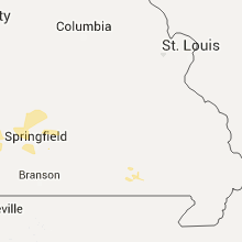
Hail Map for Thursday, June 23, 2016

Number of Impacted Households on 6/23/2016
0
Impacted by 1" or Larger Hail
0
Impacted by 1.75" or Larger Hail
0
Impacted by 2.5" or Larger Hail
Square Miles of Populated Area Impacted on 6/23/2016
0
Impacted by 1" or Larger Hail
0
Impacted by 1.75" or Larger Hail
0
Impacted by 2.5" or Larger Hail

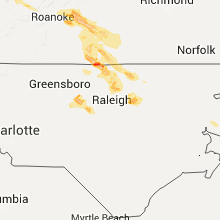


Cities Most Affected by Hail Storms of 6/23/2016
| Hail Size | Demographics of Zip Codes Affected | ||||||
|---|---|---|---|---|---|---|---|
| City | Count | Average | Largest | Pop Density | House Value | Income | Age |
| Roxboro, NC | 3 | 2.33 | 2.75 | 77 | $0k | $0.0k | 41.9 |
| Alton, VA | 2 | 2.75 | 2.75 | 27 | $64k | $28.5k | 43.7 |
| Meadow Bridge, WV | 2 | 2.00 | 2.00 | 20 | $47k | $23.0k | 47.1 |
| Forest, VA | 2 | 1.75 | 1.75 | 320 | $142k | $56.3k | 41.4 |
| Bedford, VA | 1 | 2.75 | 2.75 | 84 | $95k | $35.1k | 44.8 |
| Lynchburg, VA | 1 | 1.75 | 1.75 | 687 | $64k | $26.4k | 30.4 |
| Louisville, KY | 1 | 1.75 | 1.75 | 5315 | $85k | $33.0k | 36.0 |
Hail and Wind Damage Spotted on 6/23/2016
Filter by Report Type:Hail ReportsWind Reports
States Impacted
Virginia, West Virginia, Indiana, Ohio, North Carolina, Kentucky, Kansas, Oklahoma, New Mexico, Colorado, Missouri, Tennessee, WyomingVirginia
| Local Time | Report Details |
|---|---|
| 8:10 AM EDT | 2 trees downed along va-60 in charles city county VA, 28.2 miles E of Richmond, VA |
| 8:19 AM EDT | Trees down along stergeon pt road in charles city count in charles city county VA, 37 miles ESE of Richmond, VA |
| 8:42 AM EDT | Four to five trees reported down across the road in the crows area. time estimated from rada in alleghany county VA, 34.1 miles NNW of Roanoke, VA |
| 9:10 AM EDT | Tree reported down along rte 460 approx 3-4 miles outside of pembroke. time radar extimate in giles county VA, 34.7 miles W of Roanoke, VA |
| 9:10 AM EDT | Large tree down. broke an antenn in montgomery county VA, 27 miles W of Roanoke, VA |
| 9:12 AM EDT | Tree down blocking road at 1600 block of templeton. time radar estimate in city of roanoke county VA, 1.7 miles NE of Roanoke, VA |
| 9:12 AM EDT | Tree down on historic dr. time radar estimate in montgomery county VA, 15.1 miles W of Roanoke, VA |
| 9:24 AM EDT | Tree down on hunting hills blvd near rte 220. time radar estimate in city of roanoke county VA, 3.7 miles SSW of Roanoke, VA |
| 3:22 PM EDT | Public reports large trees down by yellow branch elementary school near evington virgini in campbell county VA, 41.9 miles E of Roanoke, VA |
| 3:50 PM EDT | Broadcast media relays report of snapped trees along big island hw in bedford county VA, 31.7 miles ENE of Roanoke, VA |
| 4:00 PM EDT | Quarter sized hail reported near Goode, VA, 31.6 miles ENE of Roanoke, VA |
| 4:02 PM EDT | Quarter sized hail reported near Goode, VA, 31.2 miles ENE of Roanoke, VA, public reports of quarter size hail near goode virginia. |
| 4:10 PM EDT | Golf Ball sized hail reported near Forest, VA, 37 miles E of Roanoke, VA, spotter reports golf ball size hail in forest virginia. |
| 4:10 PM EDT | Quarter sized hail reported near Lynchburg, VA, 40.2 miles E of Roanoke, VA, public reports quarter size hail near forest virginia. |
| 4:15 PM EDT | Golf Ball sized hail reported near Lynchburg, VA, 40.1 miles ENE of Roanoke, VA, public reports of golfball size hail southwest of lynchburg virginia. |
| 4:17 PM EDT | Golf Ball sized hail reported near Forest, VA, 36.9 miles E of Roanoke, VA, spotters reported golf ball size hail near forest virginia. |
| 4:20 PM EDT | Ping Pong Ball sized hail reported near Forest, VA, 37 miles E of Roanoke, VA, public reports ping pong size hail in forest virginia. |
| 4:30 PM EDT | Tree down charles road in campbell county VA, 40.8 miles E of Roanoke, VA |
| 4:32 PM EDT | Ping Pong Ball sized hail reported near Rustburg, VA, 46.3 miles E of Roanoke, VA |
| 4:34 PM EDT | Quarter sized hail reported near Rustburg, VA, 48 miles E of Roanoke, VA, thunderstorm produced hail the size of quarters near rustburg. |
| 5:29 PM EDT | Thunderstorm winds brought down several trees in the phoenix are in charlotte county VA, 67 miles E of Roanoke, VA |
| 5:58 PM EDT | Quarter sized hail reported near Scottsburg, VA, 69.2 miles N of Raleigh, NC, public reports quarter size hail at the exxon gas station in scottsburg virginia. |
| 5:58 PM EDT | Thunderstorm winds caused a tree to fall across james c. hagood road in halifax county... v in halifax county VA, 60.5 miles N of Raleigh, NC |
| 6:09 PM EDT | Thunderstorm winds caused the downing of two trees near the intersection of bill tuck highway and aarons creek road in halifax county... v in halifax county VA, 60.5 miles N of Raleigh, NC |
| 6:10 PM EDT | Quarter sized hail reported near Bedford, VA, 20.9 miles ENE of Roanoke, VA, 1 inch hail on wheatland road |
| 6:10 PM EDT | Baseball sized hail reported near Bedford, VA, 18.6 miles ENE of Roanoke, VA, several minutes of one to two inch hail with a few baseball size hailstones on magnola drive.cars damaged. |
| 6:30 PM EDT | Tree down blocking roa in mecklenburg county VA, 54.8 miles N of Raleigh, NC |
| 7:03 PM EDT | Numerous trees and large limbs down. time from rada in halifax county VA, 57.7 miles NNW of Raleigh, NC |
| 7:03 PM EDT | Baseball sized hail reported near Alton, VA, 57.7 miles NNW of Raleigh, NC, broadcast media station forwarded a report of baseball size hail that fell in alton va. |
| 7:03 PM EDT | Public reports several large tree limbs down on watlington road near mt airy virgini in pittsylvania county VA, 43.6 miles ESE of Roanoke, VA |
| 7:14 PM EDT | Baseball sized hail reported near Alton, VA, 54.6 miles NNW of Raleigh, NC, public reports of baseball size hail on hwy 501 just north of the virginia north carolina border. |
| 7:30 PM EDT | Thunderstorm wind took down numerous trees and powerpoles in the rich creek area of giles county... v in giles county VA, 49.6 miles W of Roanoke, VA |
| 7:39 PM EDT | Thunderstorm winds caused two trees to fall near the intersection of river road and birch elmo roads in halifax county... v in halifax county VA, 61 miles SE of Roanoke, VA |
| 7:42 PM EDT | 911 reports of a tree down on cumberland road near narrows virgini in giles county VA, 47.6 miles W of Roanoke, VA |
| 7:52 PM EDT | Thunderstorm winds caused numerous trees to fall along route 102 in tazewell county v in tazewell county VA, 69.6 miles NE of Bristol, TN |
| 8:00 PM EDT | Numerous reports of trees down in haysi and throughout dickenson count in dickenson county VA, 42.8 miles N of Bristol, TN |
| 8:01 PM EDT | Four trees reported down along route 609 in harma in buchanan county VA, 48.2 miles N of Bristol, TN |
| 8:15 PM EDT | Thunderstorm winds brought down multiple trees just west of bluefield virgini in tazewell county VA, 68.7 miles NE of Bristol, TN |
| 8:17 PM EDT | Roof blown off the binns-counts community cente in dickenson county VA, 35.2 miles NNW of Bristol, TN |
| 8:20 PM EDT | Trees down in southern buchanan county. time estimated from rada in buchanan county VA, 43 miles NNE of Bristol, TN |
| 8:30 PM EDT | 1 tree down east of honaker in russell county VA, 32.9 miles NNE of Bristol, TN |
| 8:34 PM EDT | Thunderstorm winds blew down one tree near the draper valley overloo in pulaski county VA, 49.5 miles WSW of Roanoke, VA |
| 8:45 PM EDT | One tree blown down by thunderstorm winds on route 4 in bland county VA, 62.8 miles W of Roanoke, VA |
| 8:50 PM EDT | Multiple trees down countywide ranging from around 850 pm to around 10 pm in washington county VA, 16.2 miles ENE of Bristol, TN |
| 9:01 PM EDT | Thunderstorm winds resulted in numerous trees and powerpoles down in the adwolf portion of smyth county... va. time based on rada in smyth county VA, 37.6 miles ENE of Bristol, TN |
| 9:20 PM EDT | 2 trees down - one on town branch rd and another at hether springs in lee county VA, 50.4 miles W of Bristol, TN |
| 9:51 PM EDT | Thunderstorm winds brought down one tree within the community of hillsvill in carroll county VA, 55.7 miles SW of Roanoke, VA |
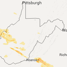
West Virginia
| Local Time | Report Details |
|---|---|
| 8:20 AM EDT | One tree blown down by thunderstorm winds on route 2 in summers county WV, 57.6 miles SE of Charleston, WV |
| 8:20 AM EDT | One tree blown down by thunderstorm wind in greenbrier county WV, 57.1 miles NNW of Roanoke, VA |
| 8:24 AM EDT | Multiple trees down along rte 20 north of hinton. time radar estimate in summers county WV, 57.4 miles SE of Charleston, WV |
| 8:26 AM EDT | Couple of trees blown down on willow wood roa in summers county WV, 54 miles WNW of Roanoke, VA |
| 8:30 AM EDT | One tree blown down by thunderstorm winds on route 1 in greenbrier county WV, 49.3 miles NW of Roanoke, VA |
| 8:30 AM EDT | Trees down in the jumping branch area. time radar estimate in summers county WV, 60.2 miles SE of Charleston, WV |
| 8:30 AM EDT | Trees down along elk knob rd in hinton. time radar estimate in summers county WV, 57.4 miles WNW of Roanoke, VA |
| 8:42 AM EDT | Trees down in pipestem area. time radar estimate in summers county WV, 59.4 miles WNW of Roanoke, VA |
| 2:58 PM EDT | Ping Pong Ball sized hail reported near Oak Hill, WV, 36.9 miles SE of Charleston, WV |
| 3:15 PM EDT | Hen Egg sized hail reported near Meadow Bridge, WV, 55.1 miles SE of Charleston, WV |
| 3:15 PM EDT | Hen Egg sized hail reported near Meadow Bridge, WV, 53 miles SE of Charleston, WV |
| 3:53 PM EDT | Trees down in cered in wayne county WV, 49.6 miles W of Charleston, WV |
| 3:57 PM EDT | Four trees down in clendenin in kanawha county WV, 18.4 miles ENE of Charleston, WV |
| 4:04 PM EDT | Tree down at spencer rd and elk river rd n in kanawha county WV, 18.4 miles ENE of Charleston, WV |
| 4:08 PM EDT | Numerous trees down. time estimated from rada in clay county WV, 25.5 miles ENE of Charleston, WV |
| 4:15 PM EDT | Quarter sized hail reported near Union, WV, 38.7 miles NW of Roanoke, VA, public reports quarter size hail near union west virginia. |
| 5:05 PM EDT | Trees down between dunlow and genoa along sr 152 in wayne county WV, 47.8 miles WSW of Charleston, WV |
| 5:08 PM EDT | Trained spotter reports trees down on auto road near renick west virgini in greenbrier county WV, 54.6 miles NNW of Roanoke, VA |
| 6:08 PM EDT | Trees down... roads blocke in martin county WV, 54.7 miles SW of Charleston, WV |
| 6:25 PM EDT | Trees down along route 8 in wyoming county WV, 42.2 miles S of Charleston, WV |
| 6:35 PM EDT | Some trees down... road blocke in mingo county WV, 54.1 miles SSW of Charleston, WV |
| 6:35 PM EDT | Trees down in mcgraws. time estimated from rada in wyoming county WV, 47.9 miles SSE of Charleston, WV |
| 6:55 PM EDT | Numerous reports of trees down throughout wyoming county...including route 5 in wyoming county WV, 54.2 miles SSE of Charleston, WV |
| 7:45 PM EDT | 911 reports of one tree down on falls mill road near bluefield west virgini in mercer county WV, 70.6 miles NE of Bristol, TN |
| 7:45 PM EDT | Thunderstorm wind caused numerous trees to come down along route 102 within mercer county causing temporary closures on the wv side of the borde in mercer county WV, 70.2 miles NE of Bristol, TN |
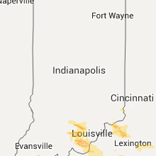
Indiana
| Local Time | Report Details |
|---|---|
| 9:00 AM EDT | 6 to 7 electric poles in a row snapped in half or tilted. time estimate in union county IN, 45 miles NNW of Cincinnati, OH |
| 3:43 PM EDT | Large tree limbs down. in washington county IN, 41.5 miles NW of Louisville, KY |
| 4:51 PM EDT | Quarter sized hail reported near Corydon, IN, 27.6 miles NW of Louisville, KY, . |
| 5:35 PM EDT | Quarter sized hail reported near Elizabeth, IN, 17.4 miles NW of Louisville, KY, . |
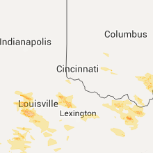
Ohio
| Local Time | Report Details |
|---|---|
| 10:29 AM EDT | Numerous large trees snapped at bush road cemetary... as well as limbs scattered throughout the are in fayette county OH, 40.7 miles SW of Columbus, OH |
| 5:35 PM EDT | Trees down in chester in meigs county OH, 52.6 miles NNW of Charleston, WV |
| 5:53 PM EDT | Tree knocked down across chesnut road. time estimated from rada in highland county OH, 54.7 miles E of Cincinnati, OH |
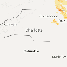
North Carolina
| Local Time | Report Details |
|---|---|
| 11:00 AM EDT | Very large tree down on house left it uninhabitable in pasquotank county NC, 28.5 miles SSW of Virginia Beach, VA |
| 5:33 PM EDT | Ping Pong Ball sized hail reported near Graham, NC, 43.4 miles WNW of Raleigh, NC, . |
| 6:25 PM EDT | Quarter sized hail reported near Pittsboro, NC, 31.9 miles W of Raleigh, NC, . |
| 6:45 PM EDT | Half Dollar sized hail reported near Bullock, NC, 52.3 miles N of Raleigh, NC, . |
| 7:12 PM EDT | Golf Ball sized hail reported near Roxboro, NC, 51 miles NNW of Raleigh, NC, . |
| 7:14 PM EDT | Baseball sized hail reported near Roxboro, NC, 54 miles NNW of Raleigh, NC, public reports of baseball size hail on hwy 501 just north of the virginia north carolina border. |
| 7:24 PM EDT | Tennis Ball sized hail reported near Roxboro, NC, 54 miles NNW of Raleigh, NC, report on u.s. route 501 just south of va state line. . |
| 7:25 PM EDT | Tree down on i-85 near exit 220. in vance county NC, 45.6 miles NNE of Raleigh, NC |
| 7:40 PM EDT | Ping Pong Ball sized hail reported near Warrenton, NC, 44.4 miles NNE of Raleigh, NC, . |
| 7:50 PM EDT | Quarter sized hail reported near Warrenton, NC, 49.7 miles NE of Raleigh, NC, . |
| 7:55 PM EDT | Thunderstorm winds caused a 12 - 15 inch pine to topple down east of yanceyville in n in caswell county NC, 55.1 miles NW of Raleigh, NC |
| 8:20 PM EDT | Thunderstorm winds resulted in numerous trees down along us 158 in the far eastern portions of caswell county in n in caswell county NC, 51.1 miles NW of Raleigh, NC |
| 8:25 PM EDT | Quarter sized hail reported near Franklinton, NC, 24 miles NNE of Raleigh, NC, . |
| 8:30 PM EDT | Multiple trees down in louisburg and bunn. in franklin county NC, 26.9 miles NE of Raleigh, NC |
| 8:30 PM EDT | Large tree down on appaloosa run east at shooting club roa in wake county NC, 12.3 miles NNW of Raleigh, NC |
| 8:30 PM EDT | Tree down on todd road. in person county NC, 46.4 miles NNW of Raleigh, NC |
| 8:35 PM EDT | Tree down on pixley pritchard road at thomas store roa in person county NC, 45.3 miles N of Raleigh, NC |
| 8:40 PM EDT | Tree down at heritage lake road and route 9 in wake county NC, 15 miles NNE of Raleigh, NC |
| 9:50 PM EDT | Several trees reported down at mcdowell and fayetteville st and zoo parkway. power outages in and around ashebor in randolph county NC, 65.2 miles ENE of Charlotte, NC |
| 10:02 PM EDT | Thunderstorm winds brought down numerous trees in the community of ennice in alleghany county... n in alleghany county NC, 68 miles E of Bristol, TN |
| 11:45 PM EDT | Tree fell on house off forestdale drive in salisbury... n in rowan county NC, 36.9 miles NNE of Charlotte, NC |
Kentucky
| Local Time | Report Details |
|---|---|
| 3:36 PM EDT | Tree down along route 2 in greenup county KY, 67.7 miles W of Charleston, WV |
| 4:20 PM EDT | A few trees down across southern part of the count in owen county KY, 45.2 miles SSW of Cincinnati, OH |
| 4:55 PM EDT | Tree down blocking blaine creek road in lawrence county KY, 55.5 miles W of Charleston, WV |
| 5:02 PM EDT | Tree reported dow in jefferson county KY, 16.8 miles N of Louisville, KY |
| 5:08 PM EDT | Trees down on the 4600 block of van thompson road near hwy 53 in montgomery county KY, 29.7 miles N of Irvine, KY |
| 5:09 PM EDT | Tree down near dundee rd and strathmoor blv in jefferson county KY, 16.1 miles N of Louisville, KY |
| 5:12 PM EDT | Tree reported dow in jefferson county KY, 18.1 miles N of Louisville, KY |
| 5:15 PM EDT | Trees down on donaldson road near the clark county lin in montgomery county KY, 26.5 miles N of Irvine, KY |
| 5:16 PM EDT | Trees reported down in valley statio in jefferson county KY, 15.7 miles NNW of Louisville, KY |
| 5:20 PM EDT | Quarter sized hail reported near Louisville, KY, 13.9 miles NNW of Louisville, KY, . |
| 5:30 PM EDT | Golf Ball sized hail reported near Louisville, KY, 16.8 miles N of Louisville, KY, . |
| 5:37 PM EDT | Quarter sized hail reported near Taylorsville, KY, 20.9 miles E of Louisville, KY, . |
| 5:37 PM EDT | Trees down on donaldson road near the clark county lin in montgomery county KY, 26.5 miles N of Irvine, KY |
| 5:40 PM EDT | Large trees down in bourbon count in bourbon county KY, 38.5 miles NNW of Irvine, KY |
| 5:41 PM EDT | Trees down on the 4600 block of van thompson road near hwy 53 in montgomery county KY, 29.7 miles N of Irvine, KY |
| 5:45 PM EDT | Tree down blocking road near rich creek road and route 32 in lawrence county KY, 63.4 miles WSW of Charleston, WV |
| 5:50 PM EDT | Tree fell through roo in jefferson county KY, 11.5 miles NW of Louisville, KY |
| 6:07 PM EDT | Tree blocking old nazareth roa in nelson county KY, 15.6 miles SE of Louisville, KY |
| 6:12 PM EDT | Tree down in bardstow in nelson county KY, 18.2 miles SE of Louisville, KY |
| 6:13 PM EDT | Power lines dow in bullitt county KY, 0.4 miles ENE of Louisville, KY |
| 6:27 PM EDT | Large tree limb blocking utz lane. time estimated from rada in boone county KY, 12.9 miles WSW of Cincinnati, OH |
| 6:30 PM EDT | Multiple trees down on highway 715 social media in menifee county KY, 22.6 miles ENE of Irvine, KY |
| 6:34 PM EDT | Tree knocked down on power line. time estimated from rada in boone county KY, 12.1 miles SW of Cincinnati, OH |
| 6:34 PM EDT | Tree knocked down. time estimated from rada in boone county KY, 11.5 miles SW of Cincinnati, OH |
| 6:36 PM EDT | Tree knocked down. time estimated from rada in boone county KY, 10.7 miles SW of Cincinnati, OH |
| 6:58 PM EDT | Tree down at elementary schoo in garrard county KY, 33.6 miles W of Irvine, KY |
| 7:00 PM EDT | Tree down in creek and large limbs in roadway on hwy 30 eas in breathitt county KY, 36.1 miles ESE of Irvine, KY |
| 7:20 PM EDT | Several trees down from social media in floyd county KY, 63.9 miles ESE of Irvine, KY |
| 7:28 PM EDT | Large tree down in rockcastle county KY, 30.9 miles SW of Irvine, KY |
| 7:35 PM EDT | Tree down reported from facebook in floyd county KY, 60.6 miles NNW of Bristol, TN |
| 7:40 PM EDT | Trees reported down near the orlando community. report came in via faceboo in rockcastle county KY, 26.2 miles SSW of Irvine, KY |
| 6:45 PM CDT | Trees reported dow in adair county KY, 59.1 miles SSE of Louisville, KY |
| 7:50 PM EDT | Trees completely blocking road on hwy 550 between mousie and garret in knott county KY, 63.1 miles ESE of Irvine, KY |
| 8:00 PM EDT | Trees down on elk fork bough camp branc in knott county KY, 56.9 miles ESE of Irvine, KY |
| 8:15 PM EDT | Trees down on sunshine lan in knott county KY, 60.7 miles ESE of Irvine, KY |
| 8:32 PM CDT | Many trees and power lines dow in edmonson county KY, 66 miles SSW of Louisville, KY |
| 8:35 PM CDT | One tree down on lynnview d in clinton county KY, 84.6 miles NW of Knoxville, TN |
| 9:13 PM CDT | Tree down across highway 31 in warren county KY, 68.3 miles NNE of Nashville, TN |
Kansas
| Local Time | Report Details |
|---|---|
| 2:40 PM CDT | Amateur radio reports the top 15 feet of an elm tree was brought down due to strong winds. time is an approximation from rada in harvey county KS, 24.3 miles N of Wichita, KS |
| 4:00 PM CDT | Delayed report of a large tree snapped with multiple large limbs broken and corn laid over in the are in butler county KS, 30.7 miles ENE of Wichita, KS |
| 6:10 PM CDT | Two telephone poles were reported downed in the pittsburg are in crawford county KS, 45.3 miles ESE of Chanute, KS |
| 6:24 PM CDT | 2 small trees uprooted in labette county KS, 23.1 miles SSE of Chanute, KS |
| 6:42 PM CDT | Large tree in road 1/4 mile north of 20th and 210 av in crawford county KS, 43.8 miles ESE of Chanute, KS |
| 6:51 PM CDT | Tree down on 560th 1/2 mile west of pittsburgh. blocking roadwa in crawford county KS, 41.3 miles ESE of Chanute, KS |
| 6:51 PM CDT | Delayed report from twitter of a gas station canopy blown over at the stockyard travel plaza. time radar estimate in labette county KS, 25.6 miles SSE of Chanute, KS |
| 7:20 PM CDT | Carport in roadway near 852 n 250th near arcadi in crawford county KS, 44.2 miles E of Chanute, KS |
| 9:16 PM MDT | Storm damage reported in stanton county KS, 63.1 miles WSW of Garden City, KS |
Oklahoma
| Local Time | Report Details |
|---|---|
| 2:50 PM CDT | Quarter sized hail reported near Medford, OK, 56.8 miles SSW of Wichita, KS, relayed via wfo ict. |
New Mexico
| Local Time | Report Details |
|---|---|
| 3:23 PM MDT | Quarter sized hail reported near Las Vegas, NM, 64.3 miles SSE of Taos, NM, mostly nickel size hail but occasionally quarter size. |
Colorado
| Local Time | Report Details |
|---|---|
| 4:45 PM MDT | 80 mph winds which destroyed 2 outbuildings in larimer county CO, 51.9 miles SSE of Laramie, WY |
| 5:05 PM MDT | Ping Pong Ball sized hail reported near Merino, CO, 56.3 miles NW of Yuma, CO |
| 5:34 PM MDT | Quarter sized hail reported near Merino, CO, 57.8 miles NW of Yuma, CO |
| 5:34 PM MDT | Quarter sized hail reported near Merino, CO, 51.3 miles WNW of Yuma, CO |
| 5:40 PM MDT | Storm damage reported in adams county CO, 36.9 miles E of Denver, CO |
| 6:15 PM MDT | 20 feet long limb down with 3.5 inch diameter. 70 mph estimated wind gus in moffat county CO, 0.7 miles WSW of Craig, CO |
| 6:24 PM MDT | Asos station craig - moffat county airport /cag in moffat county CO, 1.8 miles ESE of Craig, CO |
| 6:31 PM MDT | Storm damage reported in logan county CO, 51.3 miles N of Yuma, CO |
| 6:37 PM MDT | Storm damage reported in logan county CO, 54.1 miles N of Yuma, CO |
| 6:43 PM MDT | 20 feet long limb down with 3.5 inch diameter. 70 mph estimated wind gus in moffat county CO, 0.7 miles WSW of Craig, CO |
| 6:55 PM MDT | Awos station hayden airport /hdn/ corrected for thunderstorm wind gus in routt county CO, 17.4 miles E of Craig, CO |
| 7:30 PM MDT | Numerous large trees down. wind speed unknown. time estimated from rada in routt county CO, 37.9 miles E of Craig, CO |
| 7:30 PM MDT | One to two foot diameter trees down on us 40. time estimated from rada in routt county CO, 37.3 miles E of Craig, CO |
Missouri
| Local Time | Report Details |
|---|---|
| 6:51 PM CDT | Tree down in yar in greene county MO, 6.8 miles S of Springfield, MO |
| 7:20 PM CDT | Several trees down apprx 2 ft in diameter near reed rd and 125 near spart in christian county MO, 15.1 miles SE of Springfield, MO |
| 7:25 PM CDT | Tree down near sw springfiel in greene county MO, 6.1 miles SW of Springfield, MO |
Tennessee
| Local Time | Report Details |
|---|---|
| 10:11 PM EDT | 2 trees down - 1 in kingsport at 1011pm and 1 closer to piney flats reported at 1021pm in sullivan county TN, 19.3 miles WSW of Bristol, TN |
| 10:45 PM EDT | Multiple trees down along hwy 116 - report came in around 1045 to 1055 pm in morgan county TN, 34.7 miles WNW of Knoxville, TN |
| 1:07 AM EDT | A few trees down across knox count in knox county TN, 1.8 miles WNW of Knoxville, TN |
| 12:10 AM CDT | A few trees down in carthage in smith county TN, 47.3 miles E of Nashville, TN |
| 12:34 AM CDT | Treee on a house at 1105 38th avenue nort in davidson county TN, 7.4 miles WNW of Nashville, TN |
| 2:45 AM CDT | Several trees downed across count in davidson county TN, 0.2 miles NNW of Nashville, TN |
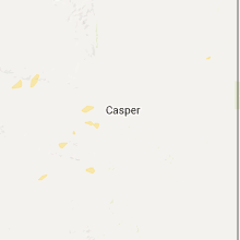
Wyoming
| Local Time | Report Details |
|---|---|
| 8:47 PM MDT | Storm damage reported in weston county WY, 52.3 miles WSW of Rapid City, SD |
Connect with Interactive Hail Maps