

Hail Map for Wednesday, June 25, 2014

Number of Impacted Households on 6/25/2014
0
Impacted by 1" or Larger Hail
0
Impacted by 1.75" or Larger Hail
0
Impacted by 2.5" or Larger Hail
Square Miles of Populated Area Impacted on 6/25/2014
0
Impacted by 1" or Larger Hail
0
Impacted by 1.75" or Larger Hail
0
Impacted by 2.5" or Larger Hail


Cities Most Affected by Hail Storms of 6/25/2014
| Hail Size | Demographics of Zip Codes Affected | ||||||
|---|---|---|---|---|---|---|---|
| City | Count | Average | Largest | Pop Density | House Value | Income | Age |
| Piedmont, SD | 1 | 2.25 | 2.25 | 23 | $88k | $41.5k | 41.4 |
| Jayton, TX | 1 | 1.75 | 1.75 | 0 | $24k | $35.5k | 46.8 |
| Holly, CO | 1 | 1.75 | 1.75 | 1 | $42k | $27.2k | 43.2 |
| Vona, CO | 1 | 1.75 | 1.75 | 1 | $38k | $30.3k | 47.1 |
| Syracuse, KS | 1 | 1.75 | 1.75 | 0 | $62k | $31.6k | 32.3 |
| Battle Creek, MI | 1 | 1.75 | 1.75 | 393 | $70k | $36.5k | 41.3 |
Hail and Wind Damage Spotted on 6/25/2014
Filter by Report Type:Hail ReportsWind Reports
States Impacted
Wisconsin, Colorado, New York, Arkansas, West Virginia, New Hampshire, Texas, South Dakota, Indiana, Louisiana, Wyoming, Michigan, Nebraska, Florida, Kansas, Pennsylvania, Montana, Utah, North DakotaWisconsin
| Local Time | Report Details |
|---|---|
| 1:06 PM CDT | Quarter sized hail reported near Prairie Du Sac, WI, 25.3 miles WNW of Madison, WI |
| 2:28 PM CDT | Half Dollar sized hail reported near Belleville, WI, 16.6 miles SSW of Madison, WI |
| 2:35 PM CDT | Quarter sized hail reported near Brooklyn, WI, 15.4 miles S of Madison, WI |
Colorado
| Local Time | Report Details |
|---|---|
| 1:15 PM MDT | Storm damage reported in arapahoe county CO, 7.8 miles ESE of Denver, CO |
| 1:43 PM MDT | Quarter sized hail reported near Walsenburg, CO, 33.5 miles S of Pueblo, CO |
| 1:45 PM MDT | Quarter sized hail reported near Walsenburg, CO, 32.1 miles S of Pueblo, CO |
| 5:54 PM MDT | Half Dollar sized hail reported near Sterling, CO, 43.7 miles NW of Yuma, CO |
| 6:04 PM MDT | Half Dollar sized hail reported near Sterling, CO, 44.2 miles NW of Yuma, CO |
| 6:07 PM MDT | Quarter sized hail reported near Sterling, CO, 44.8 miles NW of Yuma, CO |
| 6:15 PM MDT | Ping Pong Ball sized hail reported near Iliff, CO, 47.9 miles NNW of Yuma, CO, substantial crop damage in the vicinity of iliff. |
| 7:59 PM MDT | Quarter sized hail reported near Seibert, CO, 39.8 miles S of Yuma, CO |
| 8:10 PM MDT | Golf Ball sized hail reported near Vona, CO, 40.9 miles S of Yuma, CO |
| 8:11 PM MDT | Half Dollar sized hail reported near Seibert, CO, 43.7 miles S of Yuma, CO, damaged shingles. broken car windows. 0.45 inches of rainfall in 6 minutes. |
| 8:15 PM MDT | Ping Pong Ball sized hail reported near Vona, CO, 46.2 miles S of Yuma, CO, a few quarter to ping pong ball size among numerous pea size stones. time estimated from radar. |
| 8:44 PM MDT | Golf Ball sized hail reported near Holly, CO, 84.4 miles W of Garden City, KS |
New York
| Local Time | Report Details |
|---|---|
| 3:20 PM EDT | One tree dow in washington county NY, 34.8 miles ENE of Schenectady, NY |
| 3:46 PM EDT | One tree down. transformer blow in saratoga county NY, 17.1 miles N of Schenectady, NY |
| 3:46 PM EDT | One tree down... transformer blown on rock city road in saratoga county NY, 15.8 miles N of Schenectady, NY |
Arkansas
| Local Time | Report Details |
|---|---|
| 2:30 PM CDT | Trees down over roadway. roof blown off poultry barn. additional live tree limbs downed. near intersection of pleasant view road and highway 6 in franklin county AR, 28.7 miles ENE of Fort Smith, AR |
| 4:31 PM CDT | A tree was knocked down east of centerville on hwy. 15 in yell county AR, 53.9 miles WNW of Little Rock, AR |
| 7:20 PM CDT | Large tree limb down on pine street blocking the road due to thunderstorm winds in brinkle in monroe county AR, 62.3 miles E of Little Rock, AR |
West Virginia
| Local Time | Report Details |
|---|---|
| 4:26 PM EDT | Tree down at the corner of grassy lick road and briar lick road in hampshire county WV, 62.7 miles ENE of Elkins, WV |
| 5:26 PM EDT | Tree down at the corner of grassy lick road and briar lick road in hampshire county WV, 62.7 miles ENE of Elkins, WV |
| 7:18 PM EDT | Large tree uprooted and laid onto mobile home along sprinkle mill rd just east of butts park road in berkeley county WV, 71.2 miles WNW of Baltimore, MD |
| 7:18 PM EDT | Couple of large trees onto power lines and tops of trees sheared off along hanshew lane in berkeley county WV, 72.1 miles WNW of Baltimore, MD |
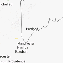
New Hampshire
| Local Time | Report Details |
|---|---|
| 4:29 PM EDT | Trees down canterbury rd in merrimack county NH, 64.1 miles WSW of Portland, ME |
Texas
| Local Time | Report Details |
|---|---|
| 3:30 PM CDT | Large tree down at el paso street and state highway 17. tree blocking highway 1 in reeves county TX, 43 miles N of Alpine, TX |
| 3:45 PM CDT | Quarter sized hail reported near Van Horn, TX, 83.7 miles NW of Alpine, TX, reported to occur at 245 to 3 pm mdt |
| 4:05 PM CDT | Power pole down on mobile home and play ground equipment displaced near intersection of n alamo and w heard. possible funnel clou in refugio county TX, 36.2 miles NNE of Corpus Christi, TX |
| 4:35 PM CDT | Ping Pong Ball sized hail reported near Perrin, TX, 65.4 miles SSE of Wichita Falls, TX, cocorahs spotter reported ping pong size hail near perrin. |
| 5:39 PM CDT | Ping Pong Ball sized hail reported near Jermyn, TX, 44.5 miles S of Wichita Falls, TX, ping pong ball sized hail along 114 in jermyn |
| 5:39 PM CDT | Strong thunderstorm winds have blown down small trees and several tree limbs in jermyn in jack county TX, 44.5 miles S of Wichita Falls, TX |
| 6:48 PM CDT | Quarter sized hail reported near Burkburnett, TX, 12.7 miles NNW of Wichita Falls, TX |
| 9:19 PM CDT | Golf Ball sized hail reported near Jayton, TX, 74.8 miles NW of Abilene, TX |
| 9:29 PM CDT | Quarter sized hail reported near Loraine, TX, 56.6 miles W of Abilene, TX, smaller hail covering the ground |
South Dakota
| Local Time | Report Details |
|---|---|
| 2:58 PM MDT | Ping Pong Ball sized hail reported near Piedmont, SD, 18.1 miles NNW of Rapid City, SD |
| 3:05 PM MDT | Quarter sized hail reported near Sturgis, SD, 18.6 miles NNW of Rapid City, SD |
| 3:15 PM MDT | Half Dollar sized hail reported near Piedmont, SD, 14.1 miles NW of Rapid City, SD |
| 3:23 PM MDT | Ping Pong Ball sized hail reported near Piedmont, SD, 13.3 miles NW of Rapid City, SD |
| 3:33 PM MDT | Hen Egg sized hail reported near Piedmont, SD, 14.1 miles NW of Rapid City, SD |
| 5:10 PM MDT | Quarter sized hail reported near Midland, SD, 48 miles WNW of Pierre, SD |
| 5:28 PM MDT | Quarter sized hail reported near Philip, SD, 57.6 miles WSW of Pierre, SD |
| 6:22 PM MDT | Half Dollar sized hail reported near Edgemont, SD, 72.8 miles SSW of Rapid City, SD |
| 6:30 PM MDT | Edgemont rwis in fall river county SD, 67.2 miles SW of Rapid City, SD |
| 6:50 PM MDT | Storm damage reported in fall river county SD, 51.5 miles S of Rapid City, SD |
| 7:00 PM MDT | Storm damage reported in custer county SD, 39.7 miles SSW of Rapid City, SD |
| 7:17 PM MDT | Storm damage reported in shannon county SD, 44.8 miles SSE of Rapid City, SD |
Indiana
| Local Time | Report Details |
|---|---|
| 5:00 PM EDT | One tree down on sr5 in lagrange county IN, 39.4 miles NW of Fort Wayne, IN |
Louisiana
| Local Time | Report Details |
|---|---|
| 4:35 PM CDT | Awos kscf wind wsw 46g64 mp in gmz455 county LA, 76.3 miles S of Lafayette, LA |
| 7:31 PM CDT | Strong rotating storm just north of the runway on the lake at that tim in orleans county LA, 6.6 miles NNE of New Orleans, LA |
Wyoming
| Local Time | Report Details |
|---|---|
| 4:17 PM MDT | Quarter sized hail reported near Gillette, WY, 15.8 miles SSE of Gillette, WY |
| 4:40 PM MDT | Ping Pong Ball sized hail reported near Rozet, WY, 18.4 miles ESE of Gillette, WY |
| 5:00 PM MDT | Quarter sized hail reported near Hulett, WY, 54.1 miles NE of Gillette, WY |
| 5:35 PM MDT | Quarter sized hail reported near Hulett, WY, 50.7 miles NE of Gillette, WY |
| 6:07 PM MDT | Quarter sized hail reported near Newcastle, WY, 68.8 miles SW of Rapid City, SD |
Michigan
| Local Time | Report Details |
|---|---|
| 6:45 PM EDT | Spotter noted waves of about 2 feet on gun lak in barry county MI, 25.6 miles SSE of Grand Rapids, MI |
| 6:45 PM EDT | Gun lake area had two inch diameter tree limbs down...car port tents destroyed...and torn boat canopie in barry county MI, 24.2 miles SSE of Grand Rapids, MI |
| 6:45 PM EDT | Several large trees down around gun lake including one on a house. report relayed by county officia in barry county MI, 26.3 miles SSE of Grand Rapids, MI |
| 6:45 PM EDT | On gun lake...boats were loosened with some torn canopies. a few storage sheds came apart and some car ports were damage in barry county MI, 24.8 miles SSE of Grand Rapids, MI |
| 6:50 PM EDT | Quarter sized hail reported near Delton, MI, 28.4 miles SSE of Grand Rapids, MI |
| 7:11 PM EDT | Quarter sized hail reported near Fremont, MI, 36.9 miles NNW of Grand Rapids, MI, report courtesy of woodtv. |
| 7:20 PM EDT | Trees and wires down in fremont and north of fremon in newaygo county MI, 36.9 miles NNW of Grand Rapids, MI |
| 7:27 PM EDT | From facebook page. a few large branches dow in newaygo county MI, 33 miles NNW of Grand Rapids, MI |
| 7:44 PM EDT | Tree down near post office in downtown battle cree in calhoun county MI, 51.2 miles SSE of Grand Rapids, MI |
| 7:46 PM EDT | Quarter sized hail reported near Battle Creek, MI, 49.4 miles SSE of Grand Rapids, MI |
| 7:48 PM EDT | Golf Ball sized hail reported near Battle Creek, MI, 50.9 miles SSE of Grand Rapids, MI |
| 7:54 PM EDT | Quarter sized hail reported near Battle Creek, MI, 53.2 miles SSE of Grand Rapids, MI |
Nebraska
| Local Time | Report Details |
|---|---|
| 4:48 PM MDT | Quarter sized hail reported near Harrison, NE, 43.4 miles NNW of Scottsbluff, NE |
| 5:15 PM MDT | Quarter sized hail reported near Harrison, NE, 44.5 miles N of Scottsbluff, NE, nickle to quarter sized hail along highway 29 at mile marker 52 south of harrison. |
| 5:47 PM MDT | Quarter sized hail reported near Crawford, NE, 58.6 miles NNE of Scottsbluff, NE |
Florida
| Local Time | Report Details |
|---|---|
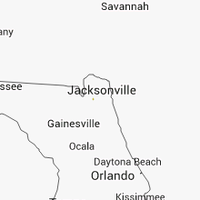
| 6:55 PM EDT | Broadcast media reporting story where tree fell through and split a home in half at 5625 atlee ave on the westside of jacksonville. no injuries were reporte in duval county FL, 5.8 miles WSW of Jacksonville, FL |
| 7:15 PM EDT | 11680 aaron road reported powerlines down in duval county FL, 8.3 miles N of Jacksonville, FL |
| 7:50 PM EDT | Broadcast media reported large tree down near dupont middle school near the intersection of dupont ave and la mesa driv in duval county FL, 5.8 miles SSE of Jacksonville, FL |
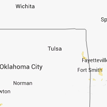
Kansas
| Local Time | Report Details |
|---|---|
| 5:10 PM MDT | Quarter sized hail reported near Syracuse, KS, 48.2 miles W of Garden City, KS |
| 5:35 PM MDT | Golf Ball sized hail reported near Syracuse, KS, 48 miles W of Garden City, KS |
| 6:22 PM MDT | Half Dollar sized hail reported near Syracuse, KS, 54.5 miles W of Garden City, KS |
| 11:26 PM CDT | Brief...isolated downburst just north of atwood. mesonet site 4 miles north of atwood reported a gust to 48 mp in rawlins county KS, 30.6 miles N of Colby, KS |
| 12:40 AM CDT | Storm damage reported in norton county KS, 68.8 miles ENE of Colby, KS |
| 1:13 AM CDT | Storm damage reported in graham county KS, 44.3 miles NW of Hays, KS |
Pennsylvania
| Local Time | Report Details |
|---|---|
| 8:10 PM EDT | Numerous trees and wires down in heidelberg... lynn... lowhill and north whitehal in lehigh county PA, 48.4 miles S of Scranton, PA |
| 8:35 PM EDT | Quarter sized hail reported near Orefield, PA, 54 miles S of Scranton, PA |
Montana
| Local Time | Report Details |
|---|---|
| 7:44 PM MDT | Quarter sized hail reported near Hinsdale, MT, 28.4 miles NW of Glasgow, MT, up to quarter size hail reported approximately 1 south bjornberg bridge on a drive toward hinsdale |
Utah
| Local Time | Report Details |
|---|---|
| 8:55 PM MDT | Kenv wendover awos 4236 ft in tooele county UT, 91 miles E of Elko, NV |
| 11:01 PM MDT | Kenv wendover awos 4236 ft in tooele county UT, 91 miles E of Elko, NV |
| 11:05 PM MDT | Dpg17 4125 ft in tooele county UT, 83 miles W of Salt Lake City, UT |
North Dakota
| Local Time | Report Details |
|---|---|
| 9:03 PM MDT | Quarter sized hail reported near Glen Ullin, ND, 51.6 miles W of Bismarck, ND |
| 9:12 PM MDT | Quarter sized hail reported near Reeder, ND, 116.3 miles WSW of Bismarck, ND |
Connect with Interactive Hail Maps