

Hail Map for Monday, June 27, 2016

Number of Impacted Households on 6/27/2016
0
Impacted by 1" or Larger Hail
0
Impacted by 1.75" or Larger Hail
0
Impacted by 2.5" or Larger Hail
Square Miles of Populated Area Impacted on 6/27/2016
0
Impacted by 1" or Larger Hail
0
Impacted by 1.75" or Larger Hail
0
Impacted by 2.5" or Larger Hail

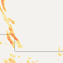


Cities Most Affected by Hail Storms of 6/27/2016
| Hail Size | Demographics of Zip Codes Affected | ||||||
|---|---|---|---|---|---|---|---|
| City | Count | Average | Largest | Pop Density | House Value | Income | Age |
| Chappell, NE | 3 | 1.83 | 2.00 | 1 | $50k | $36.1k | 47.6 |
| Haxtun, CO | 2 | 2.63 | 2.75 | 3 | $78k | $32.3k | 46.3 |
| Venango, NE | 2 | 1.88 | 2.00 | 1 | $31k | $29.8k | 49.6 |
| Chadron, NE | 2 | 1.75 | 1.75 | 8 | $62k | $37.4k | 28.6 |
| Julesburg, CO | 2 | 1.75 | 1.75 | 6 | $62k | $28.8k | 48.8 |
| Sedgwick, CO | 1 | 2.75 | 2.75 | 1 | $50k | $29.4k | 50.6 |
| Paoli, CO | 1 | 2.50 | 2.50 | 0 | $0k | $0.0k | 51.5 |
| Hillrose, CO | 1 | 1.75 | 1.75 | 13 | $81k | $30.0k | 42.5 |
| Atwood, CO | 1 | 1.75 | 1.75 | 6 | $84k | $44.3k | 47.7 |
| Hemingford, NE | 1 | 1.75 | 1.75 | 1 | $56k | $34.0k | 45.7 |
Hail and Wind Damage Spotted on 6/27/2016
Filter by Report Type:Hail ReportsWind Reports
States Impacted
South Carolina, Iowa, Colorado, North Carolina, Nebraska, Mississippi, Tennessee, Alabama, South Dakota, Georgia, Oklahoma, Texas, Arizona, Virginia, Kansas, Arkansas, CaliforniaSouth Carolina
| Local Time | Report Details |
|---|---|
| 2:17 PM EDT | Schp reported a tree down at highway 414 and meadow fork rd in greenville county SC, 20.1 miles NE of Greenville, SC |
Iowa
| Local Time | Report Details |
|---|---|
| 1:58 PM CDT | Trailer blown on its side on highway 34 in mills county IA, 22.2 miles SE of Omaha, NE |
| 3:25 PM CDT | Quarter sized hail reported near Hamburg, IA, 41.3 miles SSE of Omaha, NE, hail up to quarter size and winds up to 60 mph. also about one inch of rain. |
Colorado
| Local Time | Report Details |
|---|---|
| 1:10 PM MDT | Quarter sized hail reported near Bethune, CO, 53.5 miles SSE of Yuma, CO, quarter size hail started around 110pm mdt and is still occurring as of 135pm mdt. |
| 1:37 PM MDT | Storm damage reported in kit carson county CO, 64.6 miles SSE of Yuma, CO |
| 1:40 PM MDT | Quarter sized hail reported near Burlington, CO, 60.8 miles SSE of Yuma, CO, estimated 60-70 mph winds with blowing dust |
| 1:40 PM MDT | Semi blown over near burlington and two car accident west of burlington on highway 2 in kit carson county CO, 60.8 miles SSE of Yuma, CO |
| 3:30 PM MDT | Golf Ball sized hail reported near Hillrose, CO, 43.3 miles WNW of Yuma, CO, hail dented truck while driving on interstate 76 |
| 4:00 PM MDT | Golf Ball sized hail reported near Julesburg, CO, 64.9 miles NNE of Yuma, CO |
| 4:01 PM MDT | Golf Ball sized hail reported near Julesburg, CO, 64.9 miles NNE of Yuma, CO, very strong winds |
| 4:14 PM MDT | Golf Ball sized hail reported near Atwood, CO, 38.1 miles NW of Yuma, CO |
| 4:46 PM MDT | Ping Pong Ball sized hail reported near Julesburg, CO, 60.5 miles NNE of Yuma, CO |
| 5:03 PM MDT | Baseball sized hail reported near Sedgwick, CO, 45.4 miles NNE of Yuma, CO |
| 5:05 PM MDT | Ping Pong Ball sized hail reported near Haxtun, CO, 37.1 miles NNE of Yuma, CO, strong wind |
| 5:14 PM MDT | Quarter sized hail reported near Amherst, CO, 48.8 miles NE of Yuma, CO |
| 5:26 PM MDT | Baseball sized hail reported near Haxtun, CO, 35.1 miles NNE of Yuma, CO |
| 5:45 PM MDT | Tennis Ball sized hail reported near Paoli, CO, 36.4 miles NNE of Yuma, CO |
| 5:47 PM MDT | Tennis Ball sized hail reported near Haxtun, CO, 34.9 miles NNE of Yuma, CO, broken windows |
| 7:13 PM MDT | Quarter sized hail reported near Granada, CO, 78.3 miles W of Garden City, KS, . |
| 7:43 PM MDT | Quarter sized hail reported near Eaton, CO, 55.9 miles NNE of Denver, CO |
North Carolina
| Local Time | Report Details |
|---|---|
| 3:20 PM EDT | Quarter sized hail reported near Valdese, NC, 54.1 miles NW of Charlotte, NC, public reports quarter size hail just north of i-40 at ext 111. |
Nebraska
| Local Time | Report Details |
|---|---|
| 2:00 PM MDT | Quarter sized hail reported near Lakeside, NE, 63.3 miles E of Scottsbluff, NE |
| 2:11 PM MDT | Quarter sized hail reported near Lakeside, NE, 65.2 miles E of Scottsbluff, NE |
| 2:24 PM MDT | Quarter sized hail reported near Oshkosh, NE, 70 miles ESE of Scottsbluff, NE, hail was slightly larger than quarters |
| 2:24 PM MDT | Winds were estimated at 70+ mph. 1400 pound round bales were rolled across the pasture... in addition to 45 pound feed pallets being moved 20+ feet. trampoline which wa in garden county NE, 70 miles ESE of Scottsbluff, NE |
| 2:40 PM MDT | Ping Pong Ball sized hail reported near Oshkosh, NE, 69.5 miles ESE of Scottsbluff, NE, one window was cracked at the residents |
| 4:07 PM CDT | Quarter sized hail reported near Auburn, NE, 60.6 miles S of Omaha, NE |
| 3:15 PM MDT | Golf Ball sized hail reported near Chappell, NE, 77.2 miles NNE of Yuma, CO, ground is covered by golf ball size hail. winds were estimated at 50 mph. residents suspected wheat crop was severly damaged... but had yet to assess damage. |
| 3:30 PM MDT | Golf Ball sized hail reported near Chappell, NE, 73.2 miles NNE of Yuma, CO, hail was jagged and irregularly shaped initially |
| 3:45 PM MDT | Hen Egg sized hail reported near Chappell, NE, 64.4 miles NNE of Yuma, CO, crop damage. relayed via social media |
| 4:00 PM MDT | Quarter sized hail reported near Chappell, NE, 65.3 miles NNE of Yuma, CO, hail at least quarter size. wind gusts est 50-60 mph |
| 5:15 PM MDT | Hen Egg sized hail reported near Venango, NE, 57.1 miles NE of Yuma, CO, ground covered...relayed via social media |
| 5:15 PM MDT | Golf Ball sized hail reported near Venango, NE, 57.1 miles NE of Yuma, CO |
| 5:15 PM MDT | Ping Pong Ball sized hail reported near Venango, NE, 55.5 miles NE of Yuma, CO, ground is covered in ping pong size hail. skylight in the residents house was knocked out. wheat fields have been severely...if not completely wiped out. |
| 5:15 PM MDT | In addition to estimated 60 mph winds...wind driven ping pong size hai in perkins county NE, 55.5 miles NE of Yuma, CO |
| 5:48 PM MDT | Wind gust were estimated at 70+ mph...in addition to a few quarter size hailstone in chase county NE, 56.9 miles NE of Yuma, CO |
| 5:48 PM MDT | Quarter sized hail reported near Imperial, NE, 56.9 miles NE of Yuma, CO |
| 7:00 PM MDT | Chadron airport in dawes county NE, 73.2 miles NNE of Scottsbluff, NE |
| 7:00 PM MDT | Golf Ball sized hail reported near Chadron, NE, 73.2 miles NNE of Scottsbluff, NE, location at the chadron airport |
| 7:03 PM MDT | Golf Ball sized hail reported near Chadron, NE, 72.2 miles NNE of Scottsbluff, NE |
| 7:30 PM MDT | Quarter sized hail reported near Chadron, NE, 64.1 miles NNE of Scottsbluff, NE |
| 7:33 PM MDT | Quarter sized hail reported near Whitney, NE, 68.7 miles N of Scottsbluff, NE |
| 7:55 PM MDT | Half Dollar sized hail reported near Crawford, NE, 54.6 miles NNE of Scottsbluff, NE |
| 8:21 PM MDT | Golf Ball sized hail reported near Hemingford, NE, 47.2 miles NE of Scottsbluff, NE |
Mississippi
| Local Time | Report Details |
|---|---|
| 3:43 PM CDT | Quarter sized hail reported near Houlka, MS, 40.6 miles N of Starkville, MS, mixed hail from pea to quarter size reported in oakland tn on highway 64 near mcdonalds. time is radar estimated. |
| 4:30 PM CDT | Large oak tree down. relayed via social medi in pontotoc county MS, 59.8 miles NNW of Starkville, MS |
| 5:10 PM CDT | A 40 pound picnic table was moved about 12 ft by wind gusts in lamar county MS, 81.2 miles NNE of New Orleans, LA |
Tennessee
| Local Time | Report Details |
|---|---|
| 3:43 PM CDT | Quarter sized hail reported near Oakland, TN, 30.9 miles E of Memphis, TN, mixed hail from pea to quarter size reported in oakland tn on highway 64 near mcdonalds. time is radar estimated. |
| 3:46 PM CDT | Spotter estimates 65 mph wind gusts. a few trees down and lots of branches snappe in fayette county TN, 30.9 miles E of Memphis, TN |
| 4:30 PM CDT | Large limb down across the road on humphreys bvld near baptist childrens hospita in shelby county TN, 9.7 miles E of Memphis, TN |
Alabama
| Local Time | Report Details |
|---|---|
| 4:03 PM CDT | Small branches were reported down on walker roa in marshall county AL, 70.4 miles NNE of Birmingham, AL |
| 4:03 PM CDT | A tree was blown down across bearden road at cotton roa in marshall county AL, 70.4 miles SW of Chattanooga, TN |
| 4:12 PM CDT | Several tree down along county road 1564. three homes were damaged due to falling tree in cullman county AL, 51.6 miles N of Birmingham, AL |
| 4:32 PM CDT | A tree was reported blown down on gunter avenu in marshall county AL, 64.3 miles NNE of Birmingham, AL |
| 5:35 PM CDT | Two trees reported down... one along county road 13 and the other along county road 104 in cherokee county. location approximate. estimated 40 to 50 mile per hour winds in cherokee county AL, 59.3 miles SSW of Chattanooga, TN |
South Dakota
| Local Time | Report Details |
|---|---|
| 4:05 PM MDT | Quarter sized hail reported near Custer, SD, 28.3 miles SW of Rapid City, SD |
| 4:42 PM MDT | Quarter sized hail reported near Hot Springs, SD, 38.2 miles SSW of Rapid City, SD, hail lasted from 442 pm to 457 pm mdt. |
| 5:15 PM MDT | Quarter sized hail reported near Hot Springs, SD, 47.8 miles S of Rapid City, SD |
| 5:15 PM MDT | Ping Pong Ball sized hail reported near Hot Springs, SD, 47.8 miles S of Rapid City, SD |
| 6:25 PM MDT | Pea size hail and strong winds in fall river county SD, 53.5 miles S of Rapid City, SD |
Georgia
| Local Time | Report Details |
|---|---|
| 6:37 PM EDT | Several powerlines down in chatsworth not due to trees. tree also down on old hwy 411 at intersection of 282. peak wind at chatsworth was 31 mph in murray county GA, 36.1 miles ESE of Chattanooga, TN |
Oklahoma
| Local Time | Report Details |
|---|---|
| 5:55 PM CDT | Storm damage reported in stephens county OK, 48.9 miles NNE of Wichita Falls, TX |
| 7:00 PM CDT | Storm damage reported in major county OK, 70.8 miles NNW of Oklahoma City, OK |
| 9:35 PM CDT | Storm damage reported in dewey county OK, 43.9 miles SSE of Woodward, OK |
Texas
| Local Time | Report Details |
|---|---|
| 6:24 PM CDT | Billboard blown down at north central expressway and fitzhugh in dallas county TX, 1.1 miles ESE of Dallas, TX |
Arizona
| Local Time | Report Details |
|---|---|
| 4:29 PM MST | Asos station kingman airport /igm in mohave county AZ, 58.9 miles NNE of Lake Havasu City, AZ |
Virginia
| Local Time | Report Details |
|---|---|
| 7:37 PM EDT | One tree down at the intersection of lexington drive and inglewood road in city of lynchburg county VA, 41.5 miles ENE of Roanoke, VA |
Kansas
| Local Time | Report Details |
|---|---|
| 6:40 PM CDT | Quarter sized hail reported near Holcomb, KS, 17.6 miles NNW of Garden City, KS, . |
| 6:40 PM CDT | Winds were estimated between 60 and 70 mp in finney county KS, 17.6 miles NNW of Garden City, KS |
| 7:30 PM CDT | Emergency manager reported power line down at 1602 n 7th st in garden cit in finney county KS, 0.8 miles NNE of Garden City, KS |
| 3:57 AM CDT | Storm damage reported in ottawa county KS, 60.1 miles W of Manhattan, KS |
Arkansas
| Local Time | Report Details |
|---|---|
| 7:12 PM CDT | Large branches down near pleasant ridge shopping center off cantrell road. corrected previous tim in pulaski county AR, 7.8 miles W of Little Rock, AR |
| 7:15 PM CDT | Several reports of trees down in the st charles neighborhood in west little rock. largest tree was estimated to be 12 inches in diamete in pulaski county AR, 7.8 miles W of Little Rock, AR |
| 7:18 PM CDT | Several trees down on colonel glenn road approximately 4 miles west of interstate 43 in pulaski county AR, 11.4 miles WSW of Little Rock, AR |
| 7:39 PM CDT | Large branch dow in pulaski county AR, 7.8 miles W of Little Rock, AR |
California
| Local Time | Report Details |
|---|---|
| 5:15 PM PDT | Trees down near 90th and ave t in littleroc in los angeles county CA, 37 miles NNE of Los Angeles, CA |
| 5:15 PM PDT | Large tree down in roadway on 106th st e in sun village are in los angeles county CA, 38.4 miles NNE of Los Angeles, CA |
| 5:29 PM PDT | Power pole down on 85th st eas in los angeles county CA, 36.2 miles NNE of Los Angeles, CA |
| 5:31 PM PDT | Power lines down near 77th st and highway 138 between littlerock and pearblosso in los angeles county CA, 35.3 miles NNE of Los Angeles, CA |
| 6:50 PM PDT | Spotter reported estimated gusty north winds about 50 mph with about 1/2 wide sand/dust with downburst clearly visible. spotter described the downburst in detai in los angeles county CA, 36.9 miles NNE of Los Angeles, CA |
Connect with Interactive Hail Maps