

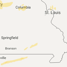
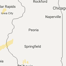
Hail Map for Monday, March 6, 2017

Number of Impacted Households on 3/6/2017
0
Impacted by 1" or Larger Hail
0
Impacted by 1.75" or Larger Hail
0
Impacted by 2.5" or Larger Hail
Square Miles of Populated Area Impacted on 3/6/2017
0
Impacted by 1" or Larger Hail
0
Impacted by 1.75" or Larger Hail
0
Impacted by 2.5" or Larger Hail


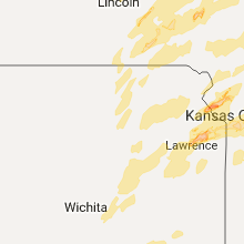


Cities Most Affected by Hail Storms of 3/6/2017
| Hail Size | Demographics of Zip Codes Affected | ||||||
|---|---|---|---|---|---|---|---|
| City | Count | Average | Largest | Pop Density | House Value | Income | Age |
| Cokato, MN | 3 | 2.50 | 4.00 | 50 | $110k | $45.3k | 32.4 |
| Independence, MO | 3 | 1.83 | 2.00 | 1034 | $76k | $39.9k | 34.1 |
| Humboldt, IA | 2 | 1.88 | 2.00 | 48 | $87k | $41.7k | 45.2 |
| Kansas City, KS | 2 | 1.88 | 2.00 | 1210 | $41k | $32.4k | 30.9 |
| Lenexa, KS | 2 | 1.88 | 2.00 | 382 | $154k | $67.0k | 38.1 |
| Shawnee, KS | 2 | 1.75 | 1.75 | 1984 | $156k | $71.8k | 37.1 |
| Edgerton, MO | 1 | 2.75 | 2.75 | 38 | $87k | $49.9k | 43.4 |
| Smithville, MO | 1 | 2.75 | 2.75 | 183 | $126k | $58.3k | 39.2 |
| De Soto, KS | 1 | 2.75 | 2.75 | 248 | $125k | $50.6k | 36.7 |
| Eudora, KS | 1 | 2.50 | 2.50 | 110 | $100k | $45.5k | 33.9 |
| Overland Park, KS | 1 | 2.00 | 2.00 | 3189 | $142k | $49.7k | 34.3 |
| Columbia, MO | 1 | 1.75 | 1.75 | 402 | $99k | $27.0k | 22.7 |
| Kansas City, MO | 1 | 1.75 | 1.75 | 2118 | $81k | $42.9k | 39.6 |
| La Grange, MO | 1 | 1.75 | 1.75 | 25 | $51k | $31.7k | 43.2 |
| Ravenwood, MO | 1 | 1.75 | 1.75 | 12 | $54k | $33.3k | 39.8 |
| Easton, KS | 1 | 1.75 | 1.75 | 22 | $89k | $49.3k | 44.8 |
| Olathe, KS | 1 | 1.75 | 1.75 | 886 | $124k | $52.8k | 33.4 |
| Lakota, IA | 1 | 1.75 | 1.75 | 5 | $34k | $31.1k | 48.2 |
| Lehigh, IA | 1 | 1.75 | 1.75 | 11 | $40k | $31.4k | 48.8 |
| Jasper, AR | 1 | 1.75 | 1.75 | 14 | $54k | $22.5k | 47.8 |
| Clarinda, IA | 1 | 1.75 | 1.75 | 28 | $69k | $37.2k | 41.6 |
| Fort Dodge, IA | 1 | 1.75 | 1.75 | 173 | $68k | $34.6k | 38.4 |
| Westboro, MO | 1 | 1.75 | 1.75 | 4 | $33k | $34.3k | 44.7 |
Hail and Wind Damage Spotted on 3/6/2017
Filter by Report Type:Hail ReportsWind Reports
States Impacted
Colorado, Iowa, Illinois, Nebraska, Minnesota, Kansas, Missouri, Oklahoma, Wisconsin, Arkansas, KentuckyColorado
| Local Time | Report Details |
|---|---|
| 6:37 AM MST | Storm damage reported in boulder county CO, 29.8 miles NW of Denver, CO |
| 8:25 AM MST | Storm damage reported in larimer county CO, 49.5 miles NNW of Denver, CO |
Iowa
| Local Time | Report Details |
|---|---|
| 10:30 AM CST | Large construction trailor just east of the office rolled over and in a ditch due to high wind in scott county IA, 63 miles ESE of Cedar Rapids, IA |
| 3:10 PM CST | Pea size hail...public report relayed by medi in ida county IA, 20.4 miles WSW of Storm Lake, IA |
| 3:15 PM CST | Quarter sized hail reported near Holstein, IA, 20.4 miles WSW of Storm Lake, IA, report via social media. |
| 3:35 PM CST | Storm damage reported in buena vista county IA, 18 miles NNE of Storm Lake, IA |
| 3:40 PM CST | Quarter sized hail reported near Missouri Valley, IA, 19.3 miles N of Omaha, NE, on i-29 just south of missouri valley exit. |
| 3:42 PM CST | Quarter sized hail reported near Honey Creek, IA, 13.3 miles NNE of Omaha, NE |
| 3:42 PM CST | Quarter sized hail reported near Honey Creek, IA, 16.4 miles NNE of Omaha, NE |
| 3:45 PM CST | Quarter sized hail reported near Logan, IA, 20.5 miles NNE of Omaha, NE, hail up to 1 inch just south of beebeetown. time estimated. |
| 4:05 PM CST | Playground equipment blown over in backyar in shelby county IA, 42.7 miles NE of Omaha, NE |
| 4:15 PM CST | Quarter sized hail reported near Avoca, IA, 34.7 miles ENE of Omaha, NE, avoca fire department reported hail ongoing up to 1 inch. winds under 50 mph. |
| 4:20 PM CST | Quarter sized hail reported near Moorland, IA, 44.8 miles ESE of Storm Lake, IA, wind driven hail broke window screens at the residence. . |
| 4:24 PM CST | Spotter reported broken storm windows as well as a few medium to large tree branches down. in emmet county IA, 56.2 miles NE of Storm Lake, IA |
| 4:24 PM CST | Golf Ball sized hail reported near Fort Dodge, IA, 48.5 miles E of Storm Lake, IA, between fort dodge and barnum. |
| 4:25 PM CST | Quarter sized hail reported near Fort Dodge, IA, 51.3 miles E of Storm Lake, IA, coop observer/trained spotter reported up to quarter sized hail. |
| 4:26 PM CST | Pea to dime size hail as well. in palo alto county IA, 53.4 miles NE of Storm Lake, IA |
| 4:30 PM CST | Tree and cable lines down. pea size hail in mills county IA, 17.9 miles SE of Omaha, NE |
| 4:35 PM CST | Ping Pong Ball sized hail reported near Humboldt, IA, 50.2 miles E of Storm Lake, IA, . |
| 4:35 PM CST | Quarter sized hail reported near Humboldt, IA, 51.5 miles E of Storm Lake, IA, pea to quarter sized hail for 5 minutes. delayed report. . |
| 4:37 PM CST | Ping Pong Ball sized hail reported near Humboldt, IA, 50.3 miles E of Storm Lake, IA, . |
| 4:38 PM CST | Quarter sized hail reported near Humboldt, IA, 50.2 miles E of Storm Lake, IA, . |
| 4:40 PM CST | Hen Egg sized hail reported near Humboldt, IA, 50.3 miles E of Storm Lake, IA, public report relayed by media on twitter. |
| 4:40 PM CST | Golf Ball sized hail reported near Humboldt, IA, 50.2 miles E of Storm Lake, IA, public reported golf ball sized hail in humboldt. |
| 4:42 PM CST | Golf Ball sized hail reported near Lakota, IA, 48.1 miles WNW of Mason City, IA, public report of golf ball hail from kaal-tv via social media. time and location estimated by radar. delayed report. |
| 4:50 PM CST | Nickel size hail as well. in calhoun county IA, 33.7 miles ESE of Storm Lake, IA |
| 4:55 PM CST | Ping Pong Ball sized hail reported near Buffalo Center, IA, 40.4 miles NW of Mason City, IA, . |
| 4:59 PM CST | Telephone lines down. pea and dime size hail in fremont county IA, 33.5 miles SE of Omaha, NE |
| 5:00 PM CST | 2 inch branches blown over. tin blown off metal buildings. doors blown off grain elevato in calhoun county IA, 33.4 miles ESE of Storm Lake, IA |
| 5:00 PM CST | Quarter sized hail reported near Goldfield, IA, 48.1 miles SW of Mason City, IA, trained spotter reported lots of quarter sized hail. . |
| 5:05 PM CST | Quarter sized hail reported near Buffalo Center, IA, 40.9 miles WNW of Mason City, IA, trained spotter reported ongoing quarter sized hail. |
| 5:08 PM CST | Cable/telephone pole blown down. pea and dime size hail also reported in fremont county IA, 38.6 miles SSE of Omaha, NE |
| 5:15 PM CST | Half Dollar sized hail reported near Jefferson, IA, 54.3 miles SE of Storm Lake, IA, 1 to 1.25 inch hail reported on social media. |
| 5:18 PM CST | Quarter sized hail reported near Gowrie, IA, 53 miles ESE of Storm Lake, IA, dime to quarter sized hail covering the ground. |
| 5:19 PM CST | Trees down in red oak cemetery. time estimated from rada in montgomery county IA, 41.4 miles ESE of Omaha, NE |
| 5:20 PM CST | Quarter sized hail reported near Gowrie, IA, 53 miles ESE of Storm Lake, IA, reported on social media. . |
| 5:33 PM CST | Golf Ball sized hail reported near Lehigh, IA, 58.9 miles ESE of Storm Lake, IA, . |
| 5:49 PM CST | Golf Ball sized hail reported near Clarinda, IA, 59.2 miles SE of Omaha, NE, dispatch estimated hail up to golf ball size |
| 5:50 PM CST | Storm damage reported in hamilton county IA, 56.3 miles SW of Mason City, IA |
| 5:55 PM CST | Semi blown on its side on highway 20 near webster city. time estimated... based on rada in hamilton county IA, 56.3 miles SW of Mason City, IA |
| 6:00 PM CST | Thunderstorm wind took out power in webster city. report via social medi in hamilton county IA, 56.9 miles SSW of Mason City, IA |
| 6:18 PM CST | Power lines down in tow in boone county IA, 48.1 miles NNW of Des Moines, IA |
| 6:21 PM CST | Storm damage reported in dallas county IA, 24.6 miles WNW of Des Moines, IA |
| 6:25 PM CST | Trained spotter reported 0.75 inch diameter hail and estimated 60 mph wind gust in franklin county IA, 21.2 miles S of Mason City, IA |
| 6:31 PM CST | Quarter sized hail reported near Earlham, IA, 26.7 miles WSW of Des Moines, IA, relayed from law enforcement. |
| 6:31 PM CST | Retired nws employee. few pieces pea size hail and small twigs down. in boone county IA, 32.5 miles NNW of Des Moines, IA |
| 6:32 PM CST | Quarter sized hail reported near Sheffield, IA, 16.2 miles SSW of Mason City, IA, nickel to quarter sized hail. |
| 6:40 PM CST | Delayed report. 1-2 ft diameter pine tree across the road. powerlines down in gilbert. small tree uprooted... limb damage. in story county IA, 37.4 miles N of Des Moines, IA |
| 6:41 PM CST | Estimated 50-60 mph wind gusts at nws des moines office. in polk county IA, 11.7 miles NNW of Des Moines, IA |
| 6:45 PM CST | Storm damage reported in story county IA, 27.6 miles N of Des Moines, IA |
| 6:45 PM CST | 50 to 60 mph wind gusts and pea sized hail. in dallas county IA, 11.1 miles W of Des Moines, IA |
| 6:49 PM CST | Nora spring f in floyd county IA, 9.7 miles E of Mason City, IA |
| 6:51 PM CST | Quarter sized hail reported near Nora Springs, IA, 9.7 miles E of Mason City, IA, nora spring fd. |
| 6:52 PM CST | Quarter sized hail reported near Rudd, IA, 15.3 miles E of Mason City, IA |
| 6:52 PM CST | Power lines down in many areas of count in floyd county IA, 15.3 miles E of Mason City, IA |
| 7:01 PM CST | Quarter sized hail reported near Floyd, IA, 20.3 miles E of Mason City, IA, floyd fd. |
| 7:03 PM CST | Dime size hai in polk county IA, 6.5 miles W of Des Moines, IA |
| 7:05 PM CST | Quarter sized hail reported near Floyd, IA, 23.3 miles E of Mason City, IA |
| 7:12 PM CST | 3 ft. diameter tree down across 210th st. in the unincorporated town of jordan. chaser said straight line winds did the damage. in boone county IA, 32.9 miles NNW of Des Moines, IA |
| 7:15 PM CST | Quarter sized hail reported near Little Cedar, IA, 28.3 miles NE of Mason City, IA |
| 7:15 PM CST | Quarter sized hail reported near Riceville, IA, 36 miles ENE of Mason City, IA |
| 7:16 PM CST | Quarter sized hail reported near Indianola, IA, 14 miles S of Des Moines, IA, . |
| 7:16 PM CST | Nickel hail as well. city of ackworth has no power. in warren county IA, 13.3 miles S of Des Moines, IA |
| 7:18 PM CST | Downed power pole over highway 92 blocking westbound traffic. time estimated by radar. straight line winds. in warren county IA, 17.4 miles SSE of Des Moines, IA |
| 7:21 PM CST | Power is reported out in in new providence with very strong winds. also pea to nickel sized hail. relayed from law enforcement. in hardin county IA, 52.9 miles NNE of Des Moines, IA |
| 7:25 PM CST | Quarter sized hail reported near Elma, IA, 33.6 miles ENE of Mason City, IA |
| 7:25 PM CST | Power poles down and a cattle building damaged near e35 and t1 in grundy county IA, 52 miles SSE of Mason City, IA |
| 7:33 PM CST | Storm damage reported in decatur county IA, 69 miles SSW of Des Moines, IA |
| 7:36 PM CST | Nickel hail as well. city of ackworth has no power. in warren county IA, 13.3 miles S of Des Moines, IA |
| 7:37 PM CST | Structure damage reported by marion county emergency manager. report location and time estimated via rada in marion county IA, 28.5 miles SE of Des Moines, IA |
| 7:45 PM CST | Storm damage reported in marshall county IA, 50.8 miles NE of Des Moines, IA |
| 7:58 PM CST | Storm damage reported in black hawk county IA, 54.9 miles NW of Cedar Rapids, IA |
| 8:00 PM CST | Storm damage reported in black hawk county IA, 53.4 miles NW of Cedar Rapids, IA |
| 8:20 PM CST | Power out 1w of seymour. very strong winds and heavy rainfall. in wayne county IA, 67.3 miles SSE of Des Moines, IA |
| 8:26 PM CST | Storm damage reported in benton county IA, 32.2 miles W of Cedar Rapids, IA |
| 8:26 PM CST | Power lines down... house damaged... barn blown down. in tama county IA, 37.3 miles W of Cedar Rapids, IA |
| 8:27 PM CST | Quarter size hai in tama county IA, 37.6 miles W of Cedar Rapids, IA |
| 8:30 PM CST | Storm damage reported in benton county IA, 27.1 miles W of Cedar Rapids, IA |
| 8:30 PM CST | Storm damage reported in benton county IA, 31.2 miles W of Cedar Rapids, IA |
| 8:30 PM CST | From trained spotter in iowa county IA, 24.7 miles WSW of Cedar Rapids, IA |
| 8:32 PM CST | Power out 1w of seymour. very strong winds and heavy rainfall. in wayne county IA, 67.3 miles SSE of Des Moines, IA |
| 8:32 PM CST | Semi and camper flipped over. power poles snapped off. in appanoose county IA, 64 miles WNW of Kahoka, MO |
| 8:35 PM CST | Storm damage reported in buchanan county IA, 47.1 miles NNW of Cedar Rapids, IA |
| 8:46 PM CST | Storm damage reported in buchanan county IA, 32.6 miles NNW of Cedar Rapids, IA |
| 8:52 PM CST | Shingles blown off hous in clayton county IA, 53.1 miles S of La Crosse, WI |
| 8:58 PM CST | Storm damage reported in linn county IA, 22.3 miles NNW of Cedar Rapids, IA |
| 9:00 PM CST | Quarter sized hail reported near Cedar Rapids, IA, 0.9 miles WSW of Cedar Rapids, IA |
| 9:01 PM CST | Storm damage reported in wapello county IA, 55.3 miles NW of Kahoka, MO |
| 9:03 PM CST | Quarter sized hail reported near Cedar Rapids, IA, 1.3 miles ESE of Cedar Rapids, IA |
| 9:04 PM CST | Storm damage reported in linn county IA, 1.9 miles SSE of Cedar Rapids, IA |
| 9:04 PM CST | Storm damage reported in clayton county IA, 47.9 miles NNE of Cedar Rapids, IA |
| 9:05 PM CST | Storm damage reported in clayton county IA, 49 miles NNE of Cedar Rapids, IA |
| 9:05 PM CST | Relayed from trained spotter in iowa county IA, 37.8 miles SSW of Cedar Rapids, IA |
| 9:06 PM CST | Relayed from trained spotter in iowa county IA, 37.8 miles SSW of Cedar Rapids, IA |
| 9:07 PM CST | Storm damage reported in clayton county IA, 62.6 miles NNE of Cedar Rapids, IA |
| 9:08 PM CST | Trees and power lines dow in clayton county IA, 47.9 miles NNE of Cedar Rapids, IA |
| 9:09 PM CST | Storm damage reported in delaware county IA, 47.2 miles NNE of Cedar Rapids, IA |
| 9:10 PM CST | Quarter sized hail reported near Marion, IA, 5.7 miles NE of Cedar Rapids, IA |
| 9:10 PM CST | Quarter sized hail reported near Cedar Rapids, IA, 1.5 miles NE of Cedar Rapids, IA |
| 9:17 PM CST | Storm damage reported in johnson county IA, 16.6 miles SSE of Cedar Rapids, IA |
| 9:17 PM CST | Storm damage reported in johnson county IA, 19.8 miles S of Cedar Rapids, IA |
| 9:18 PM CST | Storm damage reported in delaware county IA, 42.3 miles NNE of Cedar Rapids, IA |
| 9:19 PM CST | Storm damage reported in washington county IA, 36 miles SSW of Cedar Rapids, IA |
| 9:25 PM CST | Storm damage reported in jefferson county IA, 42.7 miles NNW of Kahoka, MO |
| 9:35 PM CST | Storm damage reported in jones county IA, 30.8 miles NE of Cedar Rapids, IA |
| 9:36 PM CST | Storm damage reported in dubuque county IA, 40.8 miles ENE of Cedar Rapids, IA |
| 9:39 PM CST | Storm damage reported in johnson county IA, 22.9 miles SSE of Cedar Rapids, IA |
| 9:40 PM CST | Storm damage reported in washington county IA, 33.6 miles S of Cedar Rapids, IA |
| 9:45 PM CST | Pine tree uprooted...machine shed door lost and structure of building shifted off foundatio in johnson county IA, 27.6 miles S of Cedar Rapids, IA |
| 9:48 PM CST | Storm damage reported in johnson county IA, 24.7 miles SSE of Cedar Rapids, IA |
| 9:49 PM CST | Storm damage reported in jones county IA, 40.3 miles E of Cedar Rapids, IA |
| 9:51 PM CST | Relayed from a trained spotter in mt. pleasant in henry county IA, 38.2 miles NNE of Kahoka, MO |
| 10:00 PM CST | Storm damage reported in dubuque county IA, 61.6 miles NE of Cedar Rapids, IA |
| 10:01 PM CST | Trees down...time estimated from rada in louisa county IA, 54.2 miles SSE of Cedar Rapids, IA |
| 10:10 PM CST | Damage to car por in muscatine county IA, 50.1 miles SE of Cedar Rapids, IA |
| 10:10 PM CST | Storm damage reported in muscatine county IA, 49.9 miles SSE of Cedar Rapids, IA |
| 10:10 PM CST | Tree damage and power lines down. tree on roof...near vicinity of shiller and taylor streets...possible tornad in muscatine county IA, 49.5 miles SE of Cedar Rapids, IA |
| 10:26 PM CST | Large construction trailor just east of the office rolled over and in a ditch due to high wind in scott county IA, 63 miles ESE of Cedar Rapids, IA |
| 10:28 PM CST | Storm damage reported in scott county IA, 56.4 miles ESE of Cedar Rapids, IA |
| 10:28 PM CST | Storm damage reported in scott county IA, 56.4 miles ESE of Cedar Rapids, IA |
| 10:29 PM CST | Storm damage reported in scott county IA, 61.6 miles ESE of Cedar Rapids, IA |
| 10:30 PM CST | Storm damage reported in lee county IA, 15.6 miles ENE of Kahoka, MO |
| 10:30 PM CST | Storm damage reported in lee county IA, 26.8 miles NE of Kahoka, MO |
| 10:30 PM CST | Storm damage reported in scott county IA, 61.8 miles ESE of Cedar Rapids, IA |
| 10:30 PM CST | Time estimated... tree uprooted on 5th and 11th causing damage to a house in clinton county IA, 58.9 miles E of Cedar Rapids, IA |
Illinois
| Local Time | Report Details |
|---|---|
| 11:53 AM CST | 12-inch tree limb blown down in peoria county IL, 18.7 miles NNW of Peoria, IL |
| 10:30 PM CST | Quarter sized hail reported near Quincy, IL, 38.1 miles SSE of Kahoka, MO |
| 10:36 PM CST | Storm damage reported in rock island county IL, 70.7 miles ESE of Cedar Rapids, IA |
| 10:41 PM CST | Storm damage reported in adams county IL, 43.6 miles SE of Kahoka, MO |
| 10:41 PM CST | Storm damage reported in adams county IL, 43.1 miles SE of Kahoka, MO |
| 11:00 PM CST | Roof damage to house in huntsville in schuyler county IL, 47.9 miles ESE of Kahoka, MO |
| 11:10 PM CST | Storm damage reported in mcdonough county IL, 46.1 miles W of Peoria, IL |
| 11:20 PM CST | Quarter sized hail reported near Beardstown, IL, 64.7 miles SW of Peoria, IL |
| 11:28 PM CST | Quarter sized hail reported near Maquon, IL, 31.9 miles W of Peoria, IL |
| 11:34 PM CST | Utility pole blown over in pike county IL, 66.6 miles NNW of Saint Louis, MO |
| 12:02 AM CST | Storm damage reported in peoria county IL, 4.3 miles W of Peoria, IL |
| 12:07 AM CST | Numerous trees down on state route 26 across the county. time estimated from rada in putnam county IL, 41.6 miles NNE of Peoria, IL |
| 12:08 AM CST | On a hog farm... a machine shed was damaged... a corn rib was twisted... but house was not damage in tazewell county IL, 21.1 miles S of Peoria, IL |
| 12:13 AM CST | Storm damage reported in greene county IL, 59.5 miles N of Saint Louis, MO |
| 12:15 AM CST | Storm damage reported in tazewell county IL, 12.3 miles SSE of Peoria, IL |
| 12:16 AM CST | Power line down just west of mc nabb on the mc nabb blacktop. time estimated from rada in putnam county IL, 39 miles NNE of Peoria, IL |
| 12:16 AM CST | Multiple power poles broken about half way up at 1300e and 600n. time estimated from radar in putnam county IL, 39.4 miles NNE of Peoria, IL |
| 12:17 AM CST | Numerous trees down on state route 89 across the county. time estimated from rada in putnam county IL, 39 miles NNE of Peoria, IL |
| 12:36 AM CST | Poles and lines down/bent. relayed through law enforcemen in la salle county IL, 59.4 miles NE of Peoria, IL |
| 12:36 AM CST | Large tree downed onto illinois highway 71. relayed through law enforcemen in la salle county IL, 62.8 miles NE of Peoria, IL |
| 12:40 AM CST | Storm damage reported in de kalb county IL, 56.9 miles WSW of Chicago, IL |
| 12:41 AM CST | Quarter sized hail reported near Sycamore, IL, 55.4 miles W of Chicago, IL, quarter size hail at rt 23 and rt 64. |
| 12:41 AM CST | Three to four inch diameter tree limbs blown down at rt 23 and rt 6 in de kalb county IL, 55.4 miles W of Chicago, IL |
| 12:45 AM CST | Power poles downed by the high school. home weather station observed a gust of 73 mp in de kalb county IL, 53.5 miles WSW of Chicago, IL |
| 12:52 AM CST | Awning blown off of a business in tow in macoupin county IL, 34.4 miles NE of Saint Louis, MO |
| 12:54 AM CST | A tree downed onto a car. time estimated per radar and surrounding observation in kane county IL, 34.8 miles WSW of Chicago, IL |
| 12:55 AM CST | Storm damage reported in kane county IL, 34.8 miles WSW of Chicago, IL |
| 12:55 AM CST | Gust to 59 mph at pnt awo in livingston county IL, 51.4 miles ENE of Peoria, IL |
| 1:06 AM CST | Large pine tree downe in livingston county IL, 69.2 miles SSW of Chicago, IL |
| 1:10 AM CST | Storm damage reported in will county IL, 38.6 miles SW of Chicago, IL |
| 1:12 AM CST | Highway sign blown down on i-255 in monroe county IL, 11.7 miles S of Saint Louis, MO |
| 1:13 AM CST | Storm damage reported in will county IL, 26.4 miles WSW of Chicago, IL |
| 1:30 AM CST | Storm damage reported in st. clair county IL, 22.6 miles ESE of Saint Louis, MO |
| 1:45 AM CST | Tree blown down at redwood street and camp joy roa in clinton county IL, 43.5 miles E of Saint Louis, MO |
| 2:05 AM CST | Location- intersection of shay and hamann roads. township building destroye in tazewell county IL, 19.7 miles S of Peoria, IL |
| 2:05 AM CST | Location- 22271 tobogan road. 3 grain bins and machine shed destroyed. also... a horse barn received minor damag in tazewell county IL, 20.7 miles SSE of Peoria, IL |
| 2:10 AM CST | Semi blown over at i-57 at mile marker 18 in coles county IL, 2.4 miles SE of Mattoon, IL |
| 4:15 AM CST | Downed tree limbs and power lines reporte in massac county IL, 47.2 miles ESE of Cape Girardeau, MO |
Nebraska
| Local Time | Report Details |
|---|---|
| 2:01 PM CST | Quarter sized hail reported near Oakland, NE, 48.5 miles NW of Omaha, NE |
| 3:15 PM CST | Also half inch hail in douglas county NE, 13.7 miles WNW of Omaha, NE |
| 3:15 PM CST | Quarter sized hail reported near Omaha, NE, 10.6 miles W of Omaha, NE |
| 3:20 PM CST | Pea sized hail also reported in douglas county NE, 15.6 miles W of Omaha, NE |
| 3:27 PM CST | Ping Pong Ball sized hail reported near Fort Calhoun, NE, 14.5 miles NNW of Omaha, NE |
| 3:31 PM CST | Ping Pong Ball sized hail reported near Fort Calhoun, NE, 14.5 miles NNW of Omaha, NE |
| 4:15 PM CST | Quarter sized hail reported near Avoca, NE, 33.1 miles SSW of Omaha, NE, avoca fire department reported hail ongoing up to 1 inch. winds under 50 mph. |
| 4:59 PM CST | Tin roof blown off sunroom. near auburn. via twitte in nemaha county NE, 60.3 miles S of Omaha, NE |
| 5:04 PM CST | Storm damage reported in custer county NE, 37.5 miles ENE of North Platte, NE |
| 5:45 PM CST | Quarter sized hail reported near Verdon, NE, 77.6 miles S of Omaha, NE, pea to quarter size hail. |
Minnesota
| Local Time | Report Details |
|---|---|
| 3:40 PM CST | Quarter sized hail reported near Redwood Falls, MN, 41.3 miles SE of Montevideo, MN, . |
| 3:45 PM CST | Ping Pong Ball sized hail reported near Redwood Falls, MN, 41.3 miles SE of Montevideo, MN, . |
| 3:50 PM CST | Quarter sized hail reported near Morton, MN, 45.3 miles SE of Montevideo, MN, reported at county road 65... between redwood falls and morton... mn. |
| 4:00 PM CST | Quarter sized hail reported near Redwood Falls, MN, 42 miles SE of Montevideo, MN, . |
| 4:30 PM CST | Quarter sized hail reported near Clearwater, MN, 54.5 miles NW of Minneapolis, MN, late report. |
| 4:34 PM CST | Quarter sized hail reported near Litchfield, MN, 59.2 miles E of Montevideo, MN, . |
| 4:35 PM CST | Quarter sized hail reported near Rice, MN, 71 miles NW of Minneapolis, MN, . |
| 4:40 PM CST | Quarter sized hail reported near Hutchinson, MN, 54.7 miles W of Minneapolis, MN, . |
| 4:41 PM CST | Quarter sized hail reported near Hutchinson, MN, 54.6 miles W of Minneapolis, MN, . |
| 4:42 PM CST | Quarter sized hail reported near Dassel, MN, 54.3 miles W of Minneapolis, MN, . |
| 4:43 PM CST | Quarter sized hail reported near Royalton, MN, 77.6 miles NW of Minneapolis, MN, . |
| 4:45 PM CST | Ping Pong Ball sized hail reported near Cokato, MN, 43.9 miles W of Minneapolis, MN, . |
| 4:52 PM CST | Quarter sized hail reported near Pierz, MN, 80.2 miles NNW of Minneapolis, MN, . |
| 4:53 PM CST | Quarter sized hail reported near Dassel, MN, 49.5 miles W of Minneapolis, MN, . |
| 4:56 PM CST | Golf Ball sized hail reported near Cokato, MN, 44.8 miles W of Minneapolis, MN, . |
| 4:57 PM CST | Quarter sized hail reported near Frost, MN, 44.5 miles NW of Mason City, IA, . |
| 5:00 PM CST | Golf Ball sized hail reported near Cokato, MN, 45.8 miles W of Minneapolis, MN, . |
| 5:00 PM CST | Grapefruit sized hail reported near Cokato, MN, 45.8 miles W of Minneapolis, MN, with photo. |
| 5:05 PM CST | Ping Pong Ball sized hail reported near Bricelyn, MN, 43.3 miles NW of Mason City, IA, . |
| 5:06 PM CST | Storm damage reported in morrison county MN, 80.2 miles NNW of Minneapolis, MN |
| 5:10 PM CST | Ping Pong Ball sized hail reported near Brainerd, MN, 77.9 miles SSE of Bemidji, MN, there were hailstones ranging from 1 to 1.5 inches in diameter. |
| 5:20 PM CST | Quarter sized hail reported near Alden, MN, 36.5 miles NNW of Mason City, IA, . |
| 5:20 PM CST | Half Dollar sized hail reported near Bricelyn, MN, 43.7 miles NW of Mason City, IA, . |
| 5:41 PM CST | Trees down... power lines down... and part of roof missin in sherburne county MN, 37.7 miles NNW of Minneapolis, MN |
| 5:52 PM CST | Large oak trees fallen and housing pieces wrapped around trees. possible tornado damag in sherburne county MN, 36.2 miles NNW of Minneapolis, MN |
| 5:55 PM CST | Quarter sized hail reported near Faribault, MN, 46.9 miles S of Minneapolis, MN, . |
| 6:02 PM CST | Homes and businesses damaged. many trees down with power outag in freeborn county MN, 43.5 miles N of Mason City, IA |
| 6:03 PM CST | Large grain elevator collapsed along with numerous reports of building damage and around tow in freeborn county MN, 42.8 miles N of Mason City, IA |
| 6:05 PM CST | Ping Pong Ball sized hail reported near Dalbo, MN, 46.1 miles N of Minneapolis, MN, . |
| 6:08 PM CST | Large trees down across road near u.s. hwy 169. in sherburne county MN, 43.1 miles NNW of Minneapolis, MN |
| 6:10 PM CST | 8 to 9 inch diameter trees dow in sherburne county MN, 38.5 miles NNW of Minneapolis, MN |
| 6:11 PM CST | Power out in parts of kasso in dodge county MN, 65 miles NNE of Mason City, IA |
| 6:22 PM CST | Shed roof ripped off. old garage torn off foundation and demolished. trees uproote in freeborn county MN, 41.5 miles N of Mason City, IA |
| 6:25 PM CST | Trees down across roa in goodhue county MN, 37.3 miles SSE of Minneapolis, MN |
| 6:28 PM CST | Shed blown across road and took out some power line in olmsted county MN, 65 miles SSE of Minneapolis, MN |
| 6:43 PM CST | Several utility poles down. plus numerous 20 inch diameter tree in sherburne county MN, 37.5 miles NNW of Minneapolis, MN |
| 7:30 PM CST | Small branches dow in fillmore county MN, 54.2 miles WSW of La Crosse, WI |
Kansas
| Local Time | Report Details |
|---|---|
| 5:06 PM CST | Report of a machine shed destroye in marshall county KS, 38.3 miles NNE of Manhattan, KS |
| 5:13 PM CST | Quarter sized hail reported near Olsburg, KS, 17.7 miles NNW of Manhattan, KS, dime to nickel size hail with isolated quarter size hail. |
| 5:26 PM CST | Quarter sized hail reported near Manhattan, KS, 0.4 miles W of Manhattan, KS, quarter size hail reported by em in manhattan |
| 5:35 PM CST | Semi overturned near exit 313 at 177 and i-7 in geary county KS, 8.9 miles S of Manhattan, KS |
| 5:45 PM CST | Sustained winds of 60mph with gusts of 70 mph or greater in nemaha county KS, 43.7 miles NE of Manhattan, KS |
| 6:01 PM CST | Quarter sized hail reported near Topeka, KS, 46.9 miles E of Manhattan, KS, reported at ksnt |
| 6:30 PM CST | Power poles down in cottonwood fall in chase county KS, 55.8 miles S of Manhattan, KS |
| 6:37 PM CST | Quarter sized hail reported near Americus, KS, 48.9 miles SSE of Manhattan, KS |
| 6:40 PM CST | Damage to residence on south side of el dorado. screened-in porch torn of in butler county KS, 27.6 miles ENE of Wichita, KS |
| 6:41 PM CST | Roof damage on the west side of el dorad in butler county KS, 27.6 miles ENE of Wichita, KS |
| 6:42 PM CST | Penny size hail along with the wind gus in butler county KS, 27.6 miles ENE of Wichita, KS |
| 6:44 PM CST | Quarter sized hail reported near Topeka, KS, 46.9 miles E of Manhattan, KS, reported at ksnt |
| 6:45 PM CST | Quarter sized hail reported near Augusta, KS, 19.5 miles E of Wichita, KS |
| 6:51 PM CST | Estimated 80 mph winds near k 24 and 237 road in jefferson county KS, 46.6 miles W of Kansas City, MO |
| 6:53 PM CST | 50 kt wind gust at emporia airpor in lyon county KS, 57.5 miles SSE of Manhattan, KS |
| 6:56 PM CST | Power poles down and trees down ... south of 24 and phillips road in jefferson county KS, 38.7 miles W of Kansas City, MO |
| 6:57 PM CST | Quarter sized hail reported near Leavenworth, KS, 24.8 miles WNW of Kansas City, MO, em reports 1/2 to quarter size hail on springdale in leavenworth. |
| 7:01 PM CST | Golf Ball sized hail reported near Easton, KS, 29.8 miles WNW of Kansas City, MO, em reports golf ball size hail at 207th and springdale road. |
| 7:04 PM CST | Quarter sized hail reported near El Dorado, KS, 38.1 miles ENE of Wichita, KS |
| 7:04 PM CST | Quarter sized hail reported near Nortonville, KS, 47.8 miles WNW of Kansas City, MO, . |
| 7:06 PM CST | Quarter sized hail reported near Baldwin City, KS, 42 miles WSW of Kansas City, MO |
| 7:14 PM CST | Storm damage reported in douglas county KS, 37.7 miles WSW of Kansas City, MO |
| 7:18 PM CST | Tennis Ball sized hail reported near Eudora, KS, 32.5 miles WSW of Kansas City, MO, via a social media post |
| 7:22 PM CST | Storm damage reported in johnson county KS, 27 miles WSW of Kansas City, MO |
| 7:23 PM CST | Power pole dow in leavenworth county KS, 19.7 miles WNW of Kansas City, MO |
| 7:29 PM CST | Baseball sized hail reported near De Soto, KS, 22.5 miles WSW of Kansas City, MO |
| 7:29 PM CST | Half Dollar sized hail reported near De Soto, KS, 22.5 miles WSW of Kansas City, MO, em reports 1.25 inch hail in de soto. |
| 7:29 PM CST | Quarter sized hail reported near Shawnee, KS, 15.7 miles WSW of Kansas City, MO, em relayed report from spotter of 1 inch hail near k-7 and shawnee mission parkway. |
| 7:29 PM CST | Golf Ball sized hail reported near Olathe, KS, 18.7 miles SW of Kansas City, MO, em relayed report from spotter of golf ball size hail near 111th and k-7. |
| 7:34 PM CST | Hen Egg sized hail reported near Lenexa, KS, 16.7 miles WSW of Kansas City, MO, . |
| 7:34 PM CST | Golf Ball sized hail reported near Lenexa, KS, 16.7 miles WSW of Kansas City, MO, . |
| 7:34 PM CST | Hen Egg sized hail reported near Overland Park, KS, 11.2 miles SW of Kansas City, MO |
| 7:38 PM CST | Golf Ball sized hail reported near Shawnee, KS, 15.7 miles WSW of Kansas City, MO, em relayed report from spotter of golf ball size hail at k-7 and shawnee mission parkway. |
| 7:40 PM CST | Kixd measured 57 knot gus in johnson county KS, 25.1 miles SW of Kansas City, MO |
| 7:40 PM CST | Power lines down at 183rd just west of edgerton rd. reported from a spotter. in johnson county KS, 31.5 miles SW of Kansas City, MO |
| 7:46 PM CST | Golf Ball sized hail reported near Kansas City, KS, 10 miles WSW of Kansas City, MO, media reports golf ball size hail on the ground 3 miles east of edwardsville on hwy 32. |
| 7:46 PM CST | Hen Egg sized hail reported near Kansas City, KS, 3.7 miles WSW of Kansas City, MO |
| 7:47 PM CST | Quarter sized hail reported near Shawnee, KS, 14.5 miles WSW of Kansas City, MO, 1 inch hail reported near 47th st and monticello rd. |
| 7:48 PM CST | Kojc measured 58 knot gus in johnson county KS, 19.4 miles SSW of Kansas City, MO |
| 7:49 PM CST | Ping Pong Ball sized hail reported near Mission, KS, 8.1 miles SW of Kansas City, MO, spotter reported 1.5 inch hail in merriam. |
| 7:51 PM CST | Storm damage reported in anderson county KS, 42.5 miles NNE of Chanute, KS |
| 7:52 PM CST | Storm damage reported in woodson county KS, 26.4 miles NW of Chanute, KS |
| 7:53 PM CST | Em reported power lines down near 261st and pleasant valley roa in miami county KS, 39.6 miles SW of Kansas City, MO |
| 7:57 PM CST | Half Dollar sized hail reported near Mission, KS, 4.6 miles SSW of Kansas City, MO, half dollar size hail reported at 50th st and state line rd. |
| 7:59 PM CST | Roofs blown off multiple homes and barns throughout county. numerous power lines and power poles down. several metal buildings destroye in miami county KS, 39.5 miles SSW of Kansas City, MO |
| 8:00 PM CST | Major damage to homes... including roofs... walls... and garages. there is also heavy tree damag in johnson county KS, 16.3 miles S of Kansas City, MO |
| 8:00 PM CST | Hanger destroyed at executive airpor in johnson county KS, 19.4 miles SSW of Kansas City, MO |
| 8:08 PM CST | Em relayed report from fire dept of power lines down and power out in parke in linn county KS, 51.3 miles NNE of Chanute, KS |
| 8:15 PM CST | Large trees down in linn county KS, 47.7 miles NNE of Chanute, KS |
| 8:15 PM CST | Measured 72 mph wind gust at the iola airpor in allen county KS, 17.3 miles N of Chanute, KS |
| 8:17 PM CST | Em reported house damaged with windows blown out near w 2000th rd and cr 107 in linn county KS, 50.7 miles NNE of Chanute, KS |
| 8:20 PM CST | Widespread wind damage across northern linn county. several trees down. outbuildings flattene in linn county KS, 53.8 miles SSW of Kansas City, MO |
| 8:25 PM CST | Building destroyed in linn county KS, 53.9 miles NNE of Chanute, KS |
| 8:31 PM CST | Quarter sized hail reported near Peru, KS, 55.5 miles SW of Chanute, KS |
| 8:45 PM CST | Storm damage reported in montgomery county KS, 34.3 miles SSW of Chanute, KS |
| 8:45 PM CST | Via internet submission. no description of damage reporte in bourbon county KS, 33.1 miles ENE of Chanute, KS |
| 8:50 PM CST | Barn destroyed near indian road and 115th street (8 miles west of ft. scott). relayed via e in bourbon county KS, 34.7 miles ENE of Chanute, KS |
| 8:54 PM CST | Storm damage reported in montgomery county KS, 34.3 miles SSW of Chanute, KS |
| 8:56 PM CST | Storm damage reported in montgomery county KS, 41.3 miles SSW of Chanute, KS |
| 8:58 PM CST | Quarter sized hail reported near Caney, KS, 53.6 miles SSW of Chanute, KS |
| 8:59 PM CST | Law enforcement reported 65 mph winds and quarter size hai in montgomery county KS, 28.9 miles S of Chanute, KS |
| 9:00 PM CST | Hanger destroyed at executive airpor in johnson county KS, 19.4 miles SSW of Kansas City, MO |
| 9:00 PM CST | Video from a dashcam on social media showed roof blown off a gas station store and other structure nearby. time was estimated by rada in bourbon county KS, 42 miles ENE of Chanute, KS |
| 9:05 PM CST | Storm damage reported in montgomery county KS, 45.4 miles SSW of Chanute, KS |
| 9:10 PM CST | A large tree was blown on to a mobile home. time was estimated by radar and picture was on social medi in crawford county KS, 42.4 miles ESE of Chanute, KS |
| 9:12 PM CST | 146 hwy and 50th ave... in crawford county... vehicle blown off of roadway... trees dow in crawford county KS, 25.4 miles ESE of Chanute, KS |
| 9:13 PM CST | Estimated 70 to 80 mph winds. via arma pd. no description of damage reporte in crawford county KS, 42.4 miles ESE of Chanute, KS |
| 9:25 PM CST | Tree down blocking roadwa in labette county KS, 43 miles S of Chanute, KS |
| 9:27 PM CST | Report of a house partially collapsed along with roof blown off of a machine shed near labette. also reports of numerous trees down in this locatio in labette county KS, 34.6 miles SSE of Chanute, KS |
| 9:30 PM CST | Wind damage about 6.5 miles east of scammon... kansas. multiple power poles snapped along the highway. time estimated near or before 9:30 this evening. reported via fac in cherokee county KS, 48.9 miles SE of Chanute, KS |
| 9:34 PM CST | Large tree limb down between 8th and 9th street on washington. relayed via radi in crawford county KS, 42.4 miles ESE of Chanute, KS |
| 9:35 PM CST | Hwy 69 n 8 power poles and lines down. time reported to fire dep in cherokee county KS, 53.6 miles SE of Chanute, KS |
| 11:08 PM CST | Ping Pong Ball sized hail reported near Bonner Springs, KS, 20.5 miles WSW of Kansas City, MO, em reports ping pong size hail at 158th st and kreider rd. |
| 11:45 PM CST | Golf Ball sized hail reported near Shawnee, KS, 11.4 miles SW of Kansas City, MO, golf ball size hail reported on w 71st st near widmer rd. |
Missouri
| Local Time | Report Details |
|---|---|
| 5:34 PM CST | Quarter sized hail reported near Westboro, MO, 55.7 miles SSE of Omaha, NE, dispatch relayed report of 1 inch size hail approx. 1 mile south of the ia border on us hwy 59. |
| 5:36 PM CST | Golf Ball sized hail reported near Westboro, MO, 57.7 miles SSE of Omaha, NE, . |
| 6:18 PM CST | Em relayed report from highway patrol of semi truck rolled over on i-29 at mm8 in holt county MO, 79 miles NNW of Kansas City, MO |
| 6:18 PM CST | Sheriff dept reported power lines dow in holt county MO, 79.4 miles NNW of Kansas City, MO |
| 6:25 PM CST | Sheriff dept reported trees down between forest city and orego in holt county MO, 68.1 miles NNW of Kansas City, MO |
| 6:42 PM CST | Quarter sized hail reported near Maryville, MO, 82.2 miles SE of Omaha, NE, pickering fire reported quarter size hail on hwy 71 via em. |
| 6:48 PM CST | Quarter sized hail reported near Parnell, MO, 89.4 miles SE of Omaha, NE, . |
| 6:51 PM CST | Em relayed report from citizen of shed blown into road on 220th street near ravenwoo in nodaway county MO, 86.5 miles SE of Omaha, NE |
| 6:55 PM CST | Ping Pong Ball sized hail reported near Ravenwood, MO, 86.8 miles N of Kansas City, MO, em relayed report from spotter of ping pong ball size hail in ravenwood . |
| 6:55 PM CST | Golf Ball sized hail reported near Ravenwood, MO, 86.8 miles N of Kansas City, MO, up to golf ball... saw a lot of quarter size as well. hail is covering the roads. |
| 7:16 PM CST | Em reports power lines down at west and 11th s in platte county MO, 8.3 miles NW of Kansas City, MO |
| 7:16 PM CST | Power lines down at nw 70th st and montrose av in platte county MO, 9.1 miles NNW of Kansas City, MO |
| 7:24 PM CST | Asos at mci reported 58 knots at 0124z and 0132 in platte county MO, 15.2 miles NNW of Kansas City, MO |
| 7:25 PM CST | Baseball sized hail reported near Smithville, MO, 23.9 miles N of Kansas City, MO, . |
| 7:26 PM CST | Quarter sized hail reported near Trimble, MO, 25.3 miles N of Kansas City, MO, spotter measured quarter size hail... along with power outages in town. |
| 7:29 PM CST | Baseball sized hail reported near Edgerton, MO, 28.2 miles N of Kansas City, MO, . |
| 7:32 PM CST | Reported near i-29 and barry r in platte county MO, 10.9 miles NNW of Kansas City, MO |
| 7:36 PM CST | Em relayed report from the public of house damaged at j hwy and mccomas lan in clinton county MO, 27.4 miles NNE of Kansas City, MO |
| 7:43 PM CST | Em relayed report from highway patrol of power lines down south of lathrop on mo 3 in clinton county MO, 33.1 miles NNE of Kansas City, MO |
| 7:45 PM CST | Tree down the size of a telephone pol in saline county MO, 61.8 miles E of Kansas City, MO |
| 7:46 PM CST | Kc scout reported tractor trailer rollover on sb i-35 at mm 9 in clinton county MO, 30.7 miles NNE of Kansas City, MO |
| 7:49 PM CST | *** 1 inj *** tractor trailer overturned due to wind in platte county MO, 17.3 miles NNW of Kansas City, MO |
| 7:50 PM CST | Roof damage to the weston hote in jackson county MO, 1.6 miles S of Kansas City, MO |
| 7:54 PM CST | Windows blown out of business in westport in jackson county MO, 4.3 miles S of Kansas City, MO |
| 7:55 PM CST | Kgph measured 59 knot gus in clay county MO, 21.4 miles NE of Kansas City, MO |
| 7:55 PM CST | Storm damage reported in jackson county MO, 1.6 miles S of Kansas City, MO |
| 7:55 PM CST | Storm damage reported in jackson county MO, 1.6 miles S of Kansas City, MO |
| 7:55 PM CST | Storm damage reported in jackson county MO, 1.6 miles S of Kansas City, MO |
| 7:55 PM CST | Half Dollar sized hail reported near Kansas City, MO, 1.6 miles S of Kansas City, MO, . |
| 7:59 PM CST | Em relayed report of est. 70mph winds north of jamespor in daviess county MO, 74.1 miles NE of Kansas City, MO |
| 8:00 PM CST | Power lines down on road in jackson county MO, 16.3 miles S of Kansas City, MO |
| 8:01 PM CST | Golf Ball sized hail reported near Kansas City, MO, 8.1 miles SE of Kansas City, MO, golf ball size hail reported at hwy 350 and 63rd st. |
| 8:03 PM CST | Em relayed report from grundy county fire dept of at least 60 mph winds north of trento in grundy county MO, 85.3 miles NE of Kansas City, MO |
| 8:04 PM CST | Quarter sized hail reported near Kansas City, MO, 8.3 miles SE of Kansas City, MO, . |
| 8:05 PM CST | Dispatch reported roof blown off house... along with other damage... near independence ave and english manor d in jackson county MO, 16.6 miles SE of Kansas City, MO |
| 8:05 PM CST | Hen Egg sized hail reported near Independence, MO, 8.8 miles E of Kansas City, MO |
| 8:05 PM CST | 18-20 inch diameter tree knocked over. 6-10 inch diameter branches in the roadway. in jackson county MO, 17.1 miles SE of Kansas City, MO |
| 8:05 PM CST | 6 inch limbs down in ray county MO, 33.7 miles NE of Kansas City, MO |
| 8:07 PM CST | Quarter sized hail reported near Lees Summit, MO, 15.1 miles SE of Kansas City, MO, quarter size hail reported at hwy 50 and i-470. |
| 8:08 PM CST | Klxt measured 56 knot gus in jackson county MO, 15.1 miles SE of Kansas City, MO |
| 8:08 PM CST | Quarter sized hail reported near Independence, MO, 10.5 miles E of Kansas City, MO, spotter reported 1 inch hail near 23rd st and lees summit rd. |
| 8:11 PM CST | Quarter sized hail reported near Independence, MO, 13.1 miles ESE of Kansas City, MO, ambulance reported quarter size hail at centerpoint hospital in independence . |
| 8:11 PM CST | Golf Ball sized hail reported near Independence, MO, 10.9 miles E of Kansas City, MO, relayed report of golf ball size hail at hwy 291 and salisbury rd. |
| 8:12 PM CST | Report of a shed's roof blown onto the road approx. 4 miles north of hwy 136 on route in gentry county MO, 84 miles N of Kansas City, MO |
| 8:13 PM CST | Damage to outbuildings in caldwell county MO, 53.7 miles NE of Kansas City, MO |
| 8:15 PM CST | Golf Ball sized hail reported near Independence, MO, 16.3 miles E of Kansas City, MO |
| 8:23 PM CST | Unionville dispatch relayed reports of estimated 70mph winds and 2 funnel clouds in the area per spotter in putnam county MO, 68.1 miles W of Kahoka, MO |
| 8:26 PM CST | Storm damage reported in livingston county MO, 72.8 miles NE of Kansas City, MO |
| 8:26 PM CST | Quarter sized hail reported near Chillicothe, MO, 72.8 miles NE of Kansas City, MO, . |
| 8:27 PM CST | City em reported car port blown into a roadwa in lafayette county MO, 38.7 miles E of Kansas City, MO |
| 8:29 PM CST | Two homes completely destroyed and numerous others damaged...roof off water plant and damages to the power grid. no reported injuries or transport in lafayette county MO, 34.8 miles ESE of Kansas City, MO |
| 8:35 PM CST | Quarter sized hail reported near Chula, MO, 80.8 miles NE of Kansas City, MO, fire chief reported quarter size hail. |
| 8:35 PM CST | Car port blown into roadway in lafayette county MO, 38.7 miles E of Kansas City, MO |
| 8:40 PM CST | Major damage. 1 power pole fell on a vehicle with people in it. they were rescued and unharmed. there are also power lines over the railroa in carroll county MO, 61 miles ENE of Kansas City, MO |
| 8:43 PM CST | Storm damage reported in johnson county MO, 44.1 miles ESE of Kansas City, MO |
| 8:48 PM CST | Debris from a barn over the road at n hwy and chandler rd. in cass county MO, 45.3 miles SSE of Kansas City, MO |
| 8:52 PM CST | Ping Pong Ball sized hail reported near Waverly, MO, 57.6 miles E of Kansas City, MO |
| 8:53 PM CST | Tree fell on mobile home with three people trapped insid in johnson county MO, 41.5 miles SE of Kansas City, MO |
| 8:55 PM CST | Power poles snapped...2 by 4s scattered across the road in chariton county MO, 60.8 miles NW of Columbia, MO |
| 8:57 PM CST | Report from railroad employee of train rocking back and forth... causing a possible minor train derailment and forcing trains to stop moving in the are in chariton county MO, 61.3 miles NW of Columbia, MO |
| 8:57 PM CST | Em relayed report 2x4s across the road... house roof blown off... power poles snappe in chariton county MO, 60.8 miles NW of Columbia, MO |
| 9:08 PM CST | Storm damage reported in linn county MO, 61.8 miles NNW of Columbia, MO |
| 9:14 PM CST | Asos at whiteman afb reported 58 knot in johnson county MO, 60.8 miles ESE of Kansas City, MO |
| 9:15 PM CST | 12 inch diameter bradford pear completely brok in henry county MO, 77.1 miles N of Springfield, MO |
| 9:15 PM CST | Power outag in sullivan county MO, 62.3 miles W of Kahoka, MO |
| 9:24 PM CST | Possible tornado south of nevada at the bellamy exit. power flashes. sending deputy to chec in vernon county MO, 61.3 miles E of Chanute, KS |
| 9:25 PM CST | Kirk asos reported 52 knot in adair county MO, 48.7 miles WSW of Kahoka, MO |
| 9:25 PM CST | Storm damage reported in adair county MO, 48.2 miles WSW of Kahoka, MO |
| 9:30 PM CST | A tracker trailer was blown over and blocked 1-49 near the bellamy exit south of nevada. time was estimated by rada in vernon county MO, 61.5 miles E of Chanute, KS |
| 9:30 PM CST | Power line down across hwy 12 in pettis county MO, 62.2 miles WSW of Columbia, MO |
| 9:30 PM CST | 10 inch tree limbs dow in pettis county MO, 56 miles WSW of Columbia, MO |
| 9:31 PM CST | Quarter sized hail reported near Bevier, MO, 56.4 miles NNW of Columbia, MO, nickel to quarter size hail . |
| 9:31 PM CST | Storm damage reported in macon county MO, 54.8 miles N of Columbia, MO |
| 9:40 PM CST | Trees down and grain bin moved. possible tornado...damage continues in straight line to the intersection of highway 5 and mile corner roa in cooper county MO, 35.3 miles WSW of Columbia, MO |
| 9:45 PM CST | Windows blown out of house and trees down. possible tornado...damage continues in a straight line from the previous report sw of pilot grov in cooper county MO, 28.5 miles WSW of Columbia, MO |
| 9:51 PM CST | Reported at joplin airpor in jasper county MO, 63.9 miles SE of Chanute, KS |
| 9:53 PM CST | Quarter sized hail reported near Gorin, MO, 16.9 miles WSW of Kahoka, MO, pea to quarters...winds near 45 mph. |
| 9:55 PM CST | Large limbs down over state route h. modot had to be called in to remove the in howard county MO, 24.5 miles NW of Columbia, MO |
| 9:55 PM CST | A few broken residential windows... multiple mailboxes and road signs blown over... a wooden gate completely shattere in howard county MO, 22.2 miles W of Columbia, MO |
| 10:00 PM CST | Large tree blown over onto house in shelby county MO, 45.4 miles SSW of Kahoka, MO |
| 10:03 PM CST | Via khqa tweet...building damage...trees down in emde in shelby county MO, 43.5 miles S of Kahoka, MO |
| 10:10 PM CST | Spotter at 16780 hwy 32 close to county line reporting trees down partial roof damag in cedar county MO, 36 miles NW of Springfield, MO |
| 10:20 PM CST | Golf Ball sized hail reported near Columbia, MO, 0.3 miles SE of Columbia, MO |
| 10:25 PM CST | 6 to 12 inch tree limbs dow in newton county MO, 65.1 miles WSW of Springfield, MO |
| 10:25 PM CST | Golf Ball sized hail reported near La Grange, MO, 28.1 miles SSE of Kahoka, MO |
| 10:30 PM CST | Parts of strip mall roof blown off into parking lot. intersection of vandiver and providence in boone county MO, 0.3 miles SE of Columbia, MO |
| 10:30 PM CST | Numerous large tree branches blown down. there was a report of a wooden fence completely blown down. several trees were blown dow in polk county MO, 28.4 miles NNW of Springfield, MO |
| 10:32 PM CST | Power poles broken south side of boliva in polk county MO, 27.2 miles NNW of Springfield, MO |
| 10:35 PM CST | Storm damage reported in marion county MO, 50.6 miles SSE of Kahoka, MO |
| 10:36 PM CST | No damage reported at this tim in greene county MO, 21.9 miles NW of Springfield, MO |
| 10:43 PM CST | Springfield asos reported wind gust in greene county MO, 6.2 miles WNW of Springfield, MO |
| 10:43 PM CST | 1446 hwy 97 stotts city 2-3 foot diameter tree blown ove in lawrence county MO, 37.1 miles WSW of Springfield, MO |
| 10:48 PM CST | Down power line / tree 203 gibbs pierce cit in lawrence county MO, 43 miles WSW of Springfield, MO |
| 10:50 PM CST | Hwy 5 tree landed on hous in morgan county MO, 55.4 miles SSW of Columbia, MO |
| 10:50 PM CST | Reported at oak knoll road... rocky mount... mo part of building on roa in morgan county MO, 52.5 miles SSW of Columbia, MO |
| 10:50 PM CST | A piece of roofing and siding blown off at an apartment complex off west bypass and kearney ave. time was estimated by radar and picture was on social medi in greene county MO, 3.3 miles WNW of Springfield, MO |
| 10:51 PM CST | 5 ne of fair grove on dallas county line....70 mph gust with some tree damage now 35-40mph sustaine in dallas county MO, 18.9 miles NE of Springfield, MO |
| 10:51 PM CST | Quarter sized hail reported near Fulton, MO, 21.9 miles ESE of Columbia, MO |
| 11:00 PM CST | Several buildings in downtown springfield were damaged with roof blown of in greene county MO, 0.6 miles S of Springfield, MO |
| 11:04 PM CST | Roof damage. half of roof blown off a residence. numerous reports of tree damage within the county. in christian county MO, 11.7 miles S of Springfield, MO |
| 11:04 PM CST | Large tree down north of pineville on highway w... about 2 south of 7 in mcdonald county MO, 74.1 miles WSW of Springfield, MO |
| 11:10 PM CST | Structural damage hwy 3 in laclede county MO, 40.1 miles NE of Springfield, MO |
| 11:11 PM CST | House structural damage. unspecified severity. time estimated. in laclede county MO, 44.1 miles NE of Springfield, MO |
| 11:15 PM CST | Shingles blown off... possible gutter damage. dry-wall dusting within hallways. submitted via internet. time based on rada in greene county MO, 0.1 miles NE of Springfield, MO |
| 11:17 PM CST | Confirmed structural damage on cemetery road in macks creek. waiting for additional report in camden county MO, 55.4 miles NNE of Springfield, MO |
| 11:17 PM CST | Reports of a tree several feet thick has fallen on chestnut/ and national and sign on the square has blown dow in greene county MO, 0.6 miles S of Springfield, MO |
| 11:25 PM CST | Reported at colgate and division... springfield... mo. large tree down with power outage at colgate and division in springfield per ham radi in greene county MO, 3 miles WNW of Springfield, MO |
| 11:33 PM CST | Hwy w... carports damaged... mobile home destroyed... one spotter reports it looks like a war zon in camden county MO, 55.4 miles NNE of Springfield, MO |
| 11:39 PM CST | Confirmed report of partial roof collapse. commercial building with unknown occupancy at this tim in greene county MO, 0.1 miles NE of Springfield, MO |
| 11:40 PM CST | Reported at national and chestnut... springfield... mo.large tree reported on corner of national/chestnut... storm spotter confirmed tree is dow in greene county MO, 0.6 miles E of Springfield, MO |
| 11:40 PM CST | Residence with tree on roo in greene county MO, 1.3 miles NW of Springfield, MO |
| 11:49 PM CST | Storm damage reported in lincoln county MO, 48.6 miles WNW of Saint Louis, MO |
| 11:51 PM CST | *** 2 inj *** five mobile homes blown over... another one had a tree fall on it in wentzville near west main street and hilltop drive. two people trapped at this tim in st. charles county MO, 37.8 miles WNW of Saint Louis, MO |
| 12:03 AM CST | Storm damage reported in st. charles county MO, 33.3 miles WNW of Saint Louis, MO |
| 12:05 AM CST | Siding blown off an apartment complex at executive parkway and interstate 70 in st. charles county MO, 24.5 miles WNW of Saint Louis, MO |
| 12:15 AM CST | Just got 2 reports of large trees down on the ff hwy east of ava city limits. ava fire department is working on removing tree's on ff hwy. time estimated based on radar in douglas county MO, 39.7 miles ESE of Springfield, MO |
| 12:36 AM CST | Power lines down on hwy 30 near cedar hil in jefferson county MO, 30.2 miles SW of Saint Louis, MO |
| 12:40 AM CST | Several trees blown down along highway b north northeast of hillsbor in jefferson county MO, 31.3 miles SW of Saint Louis, MO |
| 12:51 AM CST | Tree blown down at intersection of hwy 61 and hwy in jefferson county MO, 23.2 miles SSW of Saint Louis, MO |
Oklahoma
| Local Time | Report Details |
|---|---|
| 8:25 PM CST | Storm damage reported in osage county OK, 59.1 miles NNW of Tulsa, OK |
| 8:59 PM CST | Quarter sized hail reported near Chandler, OK, 35.7 miles NE of Oklahoma City, OK |
| 9:03 PM CST | Quarter sized hail reported near Arcadia, OK, 17 miles NE of Oklahoma City, OK, dime and quarter hail. |
| 9:20 PM CST | Three sections of wooden privacy fence blown down and tree blown over in washington county OK, 46.4 miles N of Tulsa, OK |
| 9:45 PM CST | Storm damage reported in craig county OK, 62.3 miles SSE of Chanute, KS |
| 9:53 PM CST | Quarter sized hail reported near Bunch, OK, 25.5 miles NW of Fort Smith, AR, hail reported just north of greasy |
| 9:55 PM CST | Quarter sized hail reported near Norman, OK, 21.7 miles SSE of Oklahoma City, OK |
| 9:55 PM CST | Quarter sized hail reported near Sand Springs, OK, 13.3 miles W of Tulsa, OK, highway 412 and 209th west avenue |
| 10:00 PM CST | Storm damage reported in craig county OK, 62.3 miles SSE of Chanute, KS |
| 10:09 PM CST | Quarter sized hail reported near Tecumseh, OK, 26.8 miles SE of Oklahoma City, OK, nickel and quarter hail. |
| 10:11 PM CST | Half Dollar sized hail reported near Prague, OK, 46.3 miles E of Oklahoma City, OK |
| 10:11 PM CST | Quarter sized hail reported near Shawnee, OK, 35.6 miles ESE of Oklahoma City, OK |
| 10:16 PM CST | Half Dollar sized hail reported near Shamrock, OK, 36.8 miles WSW of Tulsa, OK, social media report |
| 10:21 PM CST | Quarter sized hail reported near Sapulpa, OK, 11 miles SSW of Tulsa, OK |
| 10:28 PM CST | Quarter sized hail reported near Shawnee, OK, 34.6 miles ESE of Oklahoma City, OK, quarter hail. hardesty and gordon cooper. |
| 10:35 PM CST | Quarter sized hail reported near Adair, OK, 45.1 miles ENE of Tulsa, OK |
| 10:37 PM CST | 5 power poles snapped on memorial just south of 121s in tulsa county OK, 12.7 miles SSE of Tulsa, OK |
| 10:42 PM CST | Outbuilding damaged by thunderstorm wind in rogers county OK, 27 miles E of Tulsa, OK |
| 10:43 PM CST | Tree blown down onto vehicle on peoria avenu in tulsa county OK, 4.3 miles ESE of Tulsa, OK |
| 10:51 PM CST | Shingles blown off roof... siding blown off home in okmulgee county OK, 23.2 miles SSE of Tulsa, OK |
| 10:58 PM CST | Damage to buildings and roof damage from thunderstorm wind in mayes county OK, 48.1 miles ENE of Tulsa, OK |
| 11:09 PM CST | Tree limbs downed by thunderstorm wind in wagoner county OK, 31.6 miles ESE of Tulsa, OK |
| 11:40 PM CST | Damage to church on side side of city from thunderstorm wind in muskogee county OK, 44.5 miles SE of Tulsa, OK |
| 12:54 AM CST | Large tree limb down blocking a road in le flore county OK, 25.7 miles SSW of Fort Smith, AR |
Wisconsin
| Local Time | Report Details |
|---|---|
| 8:36 PM CST | Power lines down east of stoddar in vernon county WI, 10.7 miles S of La Crosse, WI |
| 8:40 PM CST | Pea size hail als in la crosse county WI, 4.6 miles NNW of La Crosse, WI |
| 8:41 PM CST | Light post and business sign blown down in downtown la crosse. time estimated from rada in la crosse county WI, 0.2 miles SSE of La Crosse, WI |
| 9:00 PM CST | Storm damage reported in la crosse county WI, 8.2 miles E of La Crosse, WI |
| 9:05 PM CST | 6 to 9 inch diameter tree blown down and blocking right east bound lane of interstate 9 in la crosse county WI, 12.2 miles ENE of La Crosse, WI |
| 9:25 PM CST | Half Dollar sized hail reported near La Farge, WI, 34.6 miles ESE of La Crosse, WI |
| 9:25 PM CST | Estimated 50 to 60 mph wind gus in vernon county WI, 34.6 miles ESE of La Crosse, WI |
| 9:32 PM CST | Asos station volk field /vok in juneau county WI, 50.8 miles E of La Crosse, WI |
| 9:33 PM CST | Powerlines down west of highway 13. time estimated from rada in clark county WI, 62.8 miles SW of Rhinelander, WI |
| 9:45 PM CST | Report via twitter showing wind damage to several structures. time estimated from rada in grant county WI, 58.3 miles SE of La Crosse, WI |
| 9:56 PM CST | Storm damage reported in wood county WI, 81.1 miles ENE of La Crosse, WI |
| 10:12 PM CST | Storm damage reported in portage county WI, 75.3 miles W of Green Bay, WI |
| 10:36 PM CST | Roof of building on highway in lafayette county WI, 38.7 miles SW of Madison, WI |
| 10:51 PM CST | Power lines down north of la vall in sauk county WI, 52.2 miles NW of Madison, WI |
| 11:00 PM CST | Trash carts airborn in dane county WI, 17.9 miles WSW of Madison, WI |
| 11:25 PM CST | Monroe airport awo in green county WI, 32.9 miles SSW of Madison, WI |
| 11:39 PM CST | One large tree down in town of middleto in dane county WI, 8.5 miles WNW of Madison, WI |
| 11:40 PM CST | Stop light turned due to strong wind in rock county WI, 23.2 miles SE of Madison, WI |
| 11:59 PM CST | Tree down in spring valley townshi in rock county WI, 30.8 miles S of Madison, WI |
| 11:59 PM CST | Tree down in avon townshi in rock county WI, 35.7 miles S of Madison, WI |
| 11:59 PM CST | Tree down in newark townshi in rock county WI, 38.7 miles SSE of Madison, WI |
| 12:15 AM CST | Watertown airport awo in jefferson county WI, 34.4 miles ENE of Madison, WI |
| 12:19 AM CST | Tree down on road near township of rubico in dodge county WI, 50.3 miles ENE of Madison, WI |
| 12:24 AM CST | Trees and power lines down in linn township. more reports of trees and power lines down in central walworth county as wel in walworth county WI, 59.8 miles SE of Madison, WI |
| 12:59 AM CST | Kenosha airport aso in kenosha county WI, 51.7 miles NNW of Chicago, IL |
Arkansas
| Local Time | Report Details |
|---|---|
| 11:18 PM CST | Report of large tree down on nw side of tow in benton county AR, 67.7 miles N of Fort Smith, AR |
| 11:48 PM CST | Golf Ball sized hail reported near Jasper, AR, 79.5 miles NE of Fort Smith, AR |
| 11:52 PM CST | Several homes have suffered damage...and the post office has been destroyed. the roof was blown off of a church...and several roadways are blocke in newton county AR, 77.5 miles ENE of Fort Smith, AR |
| 11:52 PM CST | Roof blown off of a church in newton county AR, 77 miles ENE of Fort Smith, AR |
| 11:57 PM CST | Some roofs had shingles blown off of them. trees were blown down and snappe in newton county AR, 81.6 miles ENE of Fort Smith, AR |
| 12:00 AM CST | A few large trees were blown dow in newton county AR, 83.4 miles S of Springfield, MO |
| 12:00 AM CST | Quarter sized hail reported near Hasty, AR, 83.4 miles S of Springfield, MO |
| 12:06 AM CST | Trees and power lines were blown down. multiple trees are down on the road between hasty and carve in newton county AR, 83.1 miles S of Springfield, MO |
| 12:09 AM CST | Trees and power lines were blown dow in newton county AR, 82 miles S of Springfield, MO |
| 12:23 AM CST | A second home in saint joe has been reported as destroyed by the sheriffs offic in searcy county AR, 85.8 miles SSE of Springfield, MO |
| 12:23 AM CST | Trees were blown dow in searcy county AR, 83.6 miles SSE of Springfield, MO |
| 12:25 AM CST | Trees and power lines were blown down near highway 374 and north tomahawk roa in searcy county AR, 84.8 miles SSE of Springfield, MO |
| 1:05 AM CST | Trees down on highway 309 just south of ozark in franklin county AR, 33.8 miles E of Fort Smith, AR |
| 1:12 AM CST | 1 tree down across the road nw of pinevill in izard county AR, 95 miles SE of Springfield, MO |
| 2:33 AM CST | House is destroyed with many trees and power lines down in st. jo in searcy county AR, 85.8 miles SSE of Springfield, MO |
| 2:45 AM CST | Large tree down hwy 361 and county road 216 south of black rock in lawrence county AR, 89.2 miles NW of Memphis, TN |
| 2:55 AM CST | Trees and power lines down along county road 210 and cementary road near black roc in lawrence county AR, 89.2 miles NW of Memphis, TN |
| 2:55 AM CST | Storm damage reported in lawrence county AR, 81.6 miles NW of Memphis, TN |
| 2:55 AM CST | Two trees down with one on a house on faculty drive. no injuries reporte in lawrence county AR, 84.2 miles NW of Memphis, TN |
| 3:25 AM CST | Large cedar tree snapped in half and fell 10 feet away from base of the tre in faulkner county AR, 30.9 miles N of Little Rock, AR |
| 3:30 AM CST | Trees down in holland in faulkner county AR, 29 miles N of Little Rock, AR |
| 3:35 AM CST | Report of trees down and a roof blown of in faulkner county AR, 31.4 miles N of Little Rock, AR |
| 3:35 AM CST | Report of trees down and a roof blown of in faulkner county AR, 31.4 miles N of Little Rock, AR |
| 3:40 AM CST | Spotter estimated 60 mph winds and tree limbs down 3 miles west of vilonia in faulkner county AR, 22.9 miles N of Little Rock, AR |
Kentucky
| Local Time | Report Details |
|---|---|
| 3:50 AM CST | Portion of a warehouse has collapsed roof... and another portion blown away at economy boat store on court street and 1st. trees and power lines down... and other debri in ballard county KY, 34.4 miles SE of Cape Girardeau, MO |
| 4:07 AM CST | Trees down in the community... and along highway 62 near mayfield creek bridge. power outages in the slater area. one vehicle damage in ballard county KY, 45.6 miles ESE of Cape Girardeau, MO |
| 4:15 AM CST | Power outages in brookpor in massac county IL, 52 miles ESE of Cape Girardeau, MO |
Connect with Interactive Hail Maps