

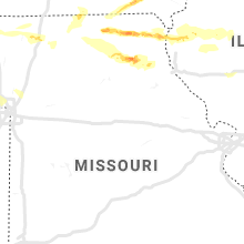
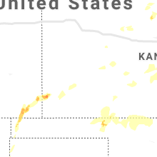
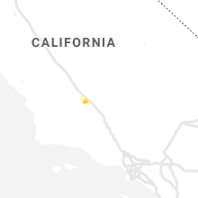
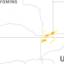
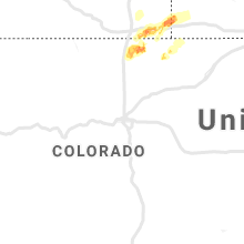
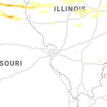
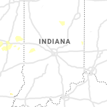
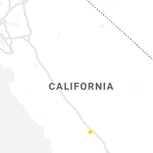
Hail Map for Saturday, May 25, 2019

Number of Impacted Households on 5/25/2019
0
Impacted by 1" or Larger Hail
0
Impacted by 1.75" or Larger Hail
0
Impacted by 2.5" or Larger Hail
Square Miles of Populated Area Impacted on 5/25/2019
0
Impacted by 1" or Larger Hail
0
Impacted by 1.75" or Larger Hail
0
Impacted by 2.5" or Larger Hail


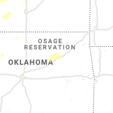

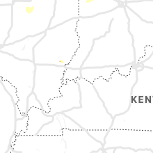


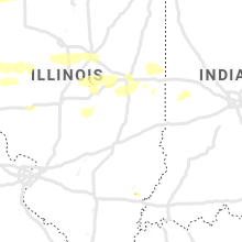


Cities Most Affected by Hail Storms of 5/25/2019
| Hail Size | Demographics of Zip Codes Affected | ||||||
|---|---|---|---|---|---|---|---|
| City | Count | Average | Largest | Pop Density | House Value | Income | Age |
| Mc Camey, TX | 6 | 2.08 | 2.75 | 0 | $31k | $26.2k | 36.2 |
| Harrisonburg, VA | 2 | 1.75 | 1.75 | 1152 | $147k | $34.3k | 23.2 |
| Imperial, TX | 1 | 2.75 | 2.75 | 0 | $22k | $26.7k | 41.9 |
| Hobbs, NM | 1 | 2.00 | 2.00 | 60 | $51k | $28.1k | 30.9 |
| Jal, NM | 1 | 2.00 | 2.00 | 0 | $27k | $30.9k | 39.1 |
| Barnesville, OH | 1 | 1.75 | 1.75 | 80 | $56k | $27.4k | 41.3 |
| Campo, CO | 1 | 1.75 | 1.75 | 0 | $22k | $24.6k | 51.3 |
| Baring, MO | 1 | 1.75 | 1.75 | 5 | $37k | $29.1k | 39.7 |
| Port Republic, VA | 1 | 1.75 | 1.75 | 83 | $126k | $49.6k | 45.5 |
Hail and Wind Damage Spotted on 5/25/2019
Filter by Report Type:Hail ReportsWind Reports
States Impacted
West Virginia, Ohio, Pennsylvania, New Mexico, Texas, Michigan, Virginia, New York, Colorado, Illinois, Kansas, Oklahoma, Missouri, California, Iowa, North Carolina, Arkansas, IndianaWest Virginia
| Local Time | Report Details |
|---|---|
| 12:49 PM EDT | Multiple trees down in the middlebourne are in tyler county WV, 69.2 miles NW of Elkins, WV |
| 1:10 PM EDT | Tree down along route 18 near intersection with route 7 in tyler county WV, 63.4 miles WNW of Elkins, WV |
| 1:10 PM EDT | Tree down along route 18 at the intersection with south frew circl in tyler county WV, 65.4 miles NW of Elkins, WV |
| 1:20 PM EDT | Viewer reports several tree limbs down and no power. viewer said it had occurred around 130 pm... radar indicates about 10 minutes earlie in harrison county WV, 41 miles NW of Elkins, WV |
| 1:55 PM EDT | ** corrected for time ** viewer reports several tree limbs down and no power. viewer said it had occurred around 130 pm... radar indicates about 25 minutes late in harrison county WV, 41 miles NW of Elkins, WV |
| 2:21 PM EDT | One or more trees down in boothsvill in harrison county WV, 36.5 miles NNW of Elkins, WV |
| 2:22 PM EDT | Quarter sized hail reported near Bridgeport, WV, 36.2 miles NNW of Elkins, WV, small branches down around the property. hail lasted around a minute... near the intersection of rt 73 and corbin branch rd. with picture/video via twitter. |
| 2:30 PM EDT | Trees and powerlines dow in taylor county WV, 30.2 miles NNW of Elkins, WV |
| 2:37 PM EDT | Corrected to elaborate on damage. multiple reports of trees and powerlines down in the cit in taylor county WV, 30.2 miles NNW of Elkins, WV |
| 2:37 PM EDT | Corrected to elaborate on damage. multiple reports of trees and powerlines down in the cit in taylor county WV, 30.2 miles NNW of Elkins, WV |
| 6:17 PM EDT | Trees down in the middlebourne are in tyler county WV, 69.2 miles NW of Elkins, WV |
Ohio
| Local Time | Report Details |
|---|---|
| 1:15 PM EDT | Storm damage reported in putnam county OH, 58.5 miles E of Fort Wayne, IN |
| 1:36 PM EDT | Trees and power lines down on decker avenu in hancock county OH, 76.8 miles E of Fort Wayne, IN |
| 4:30 PM EDT | Large trees dow in stark county OH, 48.2 miles SSE of Cleveland, OH |
| 4:35 PM EDT | Quarter sized hail reported near Akron, OH, 33.1 miles SSE of Cleveland, OH, quarter size hail reported by mping. |
| 4:35 PM EDT | Quarter sized hail reported near Akron, OH, 33.5 miles SSE of Cleveland, OH |
| 4:37 PM EDT | Multiple reports of large trees blown down and power lines blocking roads in south akron. roads blocked and impassabl in summit county OH, 33.4 miles SSE of Cleveland, OH |
| 4:40 PM EDT | Quarter sized hail reported near Akron, OH, 33.6 miles SSE of Cleveland, OH, quarter to half dollar size hail. |
| 4:40 PM EDT | Corrects previous tstm wnd gst report from 1 ssw green. reported at akron fulton international airpor in summit county OH, 42.4 miles SSE of Cleveland, OH |
| 4:40 PM EDT | Quarter sized hail reported near Akron, OH, 33.3 miles SSE of Cleveland, OH, picture and report from facebook. |
| 4:40 PM EDT | Corrects lat/lon from previous correctio in summit county OH, 34 miles SSE of Cleveland, OH |
| 4:43 PM EDT | Quarter sized hail reported near Akron, OH, 35.4 miles SSE of Cleveland, OH |
| 5:00 PM EDT | Multiple trees down reported at firestone park ohi in summit county OH, 33.9 miles SSE of Cleveland, OH |
| 5:00 PM EDT | A tree was uprooted near kenyon ave and hwy 172. multiple trees and power lines blown down around massilo in stark county OH, 48.9 miles S of Cleveland, OH |
| 5:04 PM EDT | Half Dollar sized hail reported near Uhrichsville, OH, 72.1 miles W of Pittsburgh, PA |
| 5:09 PM EDT | Large tree on a house. multiple roads blocked in the canton area due to trees and lines dow in stark county OH, 51.7 miles SSE of Cleveland, OH |
| 5:10 PM EDT | Multiple trees and power lines blown down in canton. time was estimated by rada in stark county OH, 51.4 miles SSE of Cleveland, OH |
| 5:22 PM EDT | Golf Ball sized hail reported near Barnesville, OH, 68 miles WSW of Pittsburgh, PA |
| 5:25 PM EDT | Quarter sized hail reported near Belmont, OH, 61.8 miles WSW of Pittsburgh, PA |
| 5:55 PM EDT | Trees down blocking ensign road in western trumball county. multiple reports of trees blown down in northwestern trumball count in trumbull county OH, 39.4 miles ESE of Cleveland, OH |
| 6:00 PM EDT | Multiple trees and power lines down in northern trumbull county blocking road in trumbull county OH, 46.9 miles E of Cleveland, OH |
| 6:21 PM EDT | Measured gust to 65 mp in stark county OH, 53.7 miles SSE of Cleveland, OH |
| 6:41 PM EDT | Damage at the becky-lyn mobile home park in carroll county OH, 58.4 miles W of Pittsburgh, PA |
| 8:06 PM EDT | Tree down in belmont county OH, 56.6 miles WSW of Pittsburgh, PA |
| 5:59 AM EDT | Trees fell on wildcat road... causing an accident. time estimated from rada in darke county OH, 68.4 miles SSE of Fort Wayne, IN |
| 6:10 AM EDT | Trees fell on childrens home-bradford road... causing an accident. time estimated from rada in darke county OH, 71.4 miles N of Cincinnati, OH |
| 6:22 AM EDT | Tree fell on house in piqua. time estimated from rada in miami county OH, 67.4 miles WNW of Columbus, OH |
| 6:23 AM EDT | Trees down on power lines at state route 47 and herring road intersection. officers responded. time estimated from rada in shelby county OH, 62.7 miles WNW of Columbus, OH |
| 6:30 AM EDT | One tree down on north oak road and power pole down on houser road. time estimated from rada in logan county OH, 61.1 miles NW of Columbus, OH |
| 7:21 AM EDT | Multiple utility poles down causing road closure at jerome road and blaney road intersection. time estimated from rada in union county OH, 18.3 miles NNW of Columbus, OH |
Pennsylvania
| Local Time | Report Details |
|---|---|
| 2:15 PM EDT | Telephone pole down as well as power line in fayette county PA, 26.7 miles SSE of Pittsburgh, PA |
| 2:20 PM EDT | Trees and power lines dow in fayette county PA, 33.3 miles S of Pittsburgh, PA |
| 2:30 PM EDT | Telephone pole down as well as power line in fayette county PA, 26.7 miles SSE of Pittsburgh, PA |
| 2:35 PM EDT | Trees and power lines dow in fayette county PA, 33.3 miles S of Pittsburgh, PA |
| 3:01 PM EDT | Wires down causing a brush fire in westmoreland county PA, 39.5 miles ESE of Pittsburgh, PA |
| 6:10 PM EDT | Multiple reports of trees and power lines down near hartstown golf course and highway 32 in crawford county PA, 66.5 miles E of Cleveland, OH |
| 6:14 PM EDT | Several trees and power lines blown down near meadville reported through 9-1-1 dispatch radio traffi in crawford county PA, 79.9 miles E of Cleveland, OH |
| 7:00 PM EDT | Trees uprooted... with one falling on a vehicl in venango county PA, 70.2 miles NNE of Pittsburgh, PA |
| 7:34 PM EDT | Quarter sized hail reported near Gibsonia, PA, 13.3 miles N of Pittsburgh, PA |
| 7:55 PM EDT | Trees down in westmoreland county PA, 17.8 miles ENE of Pittsburgh, PA |
| 7:57 PM EDT | Trees down in westmoreland county PA, 20.9 miles ENE of Pittsburgh, PA |
| 8:06 PM EDT | Wires down on grant street in ridgwa in elk county PA, 63.1 miles NW of State College, PA |
| 8:08 PM EDT | Trees down in townsend park in westmoreland county PA, 17.3 miles E of Pittsburgh, PA |
| 8:09 PM EDT | Trees and wires dow in mckean county PA, 75.8 miles NNW of State College, PA |
| 8:10 PM EDT | Trees and wires down in johnsonbur in elk county PA, 64.3 miles NW of State College, PA |
| 8:14 PM EDT | Trees down in westmoreland county PA, 23.3 miles E of Pittsburgh, PA |
| 8:30 PM EDT | Carmichaels fire dpt reports several trees down bloacking roads around the are in greene county PA, 37.1 miles S of Pittsburgh, PA |
| 8:37 PM EDT | Trees down in indiana county PA, 44.7 miles E of Pittsburgh, PA |
| 8:45 PM EDT | Trees dow in potter county PA, 77.7 miles N of State College, PA |
New Mexico
| Local Time | Report Details |
|---|---|
| 12:38 PM MDT | Quarter sized hail reported near Clovis, NM, 59.7 miles SSE of Tucumcari, NM, clovis high school |
| 12:40 PM MDT | Quarter sized hail reported near Clovis, NM, 60.3 miles SSE of Tucumcari, NM |
| 1:30 PM MDT | Half Dollar sized hail reported near Clovis, NM, 50.3 miles SSE of Tucumcari, NM |
| 2:18 PM MDT | Ping Pong Ball sized hail reported near Jal, NM, 51.1 miles WNW of Odessa, TX |
| 2:30 PM MDT | Hen Egg sized hail reported near Jal, NM, 51.1 miles WNW of Odessa, TX, hail lasted from 325-330 pm cdt. mostly golfball sized hail with some a little bigger. |
| 3:05 PM MDT | Hen Egg sized hail reported near Hobbs, NM, 73.9 miles NW of Odessa, TX |
Texas
| Local Time | Report Details |
|---|---|
| 2:39 PM CDT | Quarter sized hail reported near , , 52.2 miles WSW of Odessa, TX, hail lasted from 235 to 239 pm. |
| 2:52 PM CDT | Ping Pong Ball sized hail reported near Imperial, TX, 42.9 miles SSW of Odessa, TX, imperial reservoir |
| 2:52 PM CDT | Ping Pong Ball sized hail reported near Imperial, TX, 48.4 miles SW of Odessa, TX, imperial reservoir |
| 3:00 PM CDT | Baseball sized hail reported near Imperial, TX, 48.4 miles SW of Odessa, TX |
| 3:20 PM CDT | Quarter sized hail reported near Borger, TX, 39.7 miles NE of Amarillo, TX |
| 3:57 PM CDT | Quarter sized hail reported near , , 53.5 miles SW of Odessa, TX |
| 4:00 PM CDT | Quarter sized hail reported near Silverton, TX, 59.2 miles SSE of Amarillo, TX, winds 40-50 mph |
| 4:50 PM CDT | Measured by the plains west texas mesonet in yoakum county TX, 61.6 miles WSW of Lubbock, TX |
| 4:50 PM CDT | Large tree down in plains blocking a roadway. time of damage estimate in yoakum county TX, 62.8 miles WSW of Lubbock, TX |
| 4:55 PM CDT | Measured by the plains west texas mesonet in yoakum county TX, 62.1 miles WSW of Lubbock, TX |
| 4:58 PM CDT | Storm damage reported in ochiltree county TX, 75.3 miles W of Woodward, OK |
| 5:40 PM CDT | Strong winds blew over a semi. a cell tower was blown down. a mobile home was flipped over. damage may have been related to a strong circulation/tornado that moved by t in hale county TX, 41.9 miles N of Lubbock, TX |
| 5:50 PM CDT | Up to 2...400 people without power in plainview immediately after the storm passage in hale county TX, 41.9 miles N of Lubbock, TX |
| 5:52 PM CDT | Wheeler raws site recorded 66 mph peak wind gus in wheeler county TX, 70.4 miles N of Childress, TX |
| 6:01 PM CDT | Trees uprooted. time estimated from radar dat in wheeler county TX, 69.7 miles N of Childress, TX |
| 6:22 PM CDT | Quarter sized hail reported near Mc Camey, TX, 51.1 miles S of Odessa, TX |
| 6:28 PM CDT | Baseball sized hail reported near Mc Camey, TX, 50.4 miles S of Odessa, TX |
| 6:35 PM CDT | Tennis Ball sized hail reported near Mc Camey, TX, 50.4 miles S of Odessa, TX |
| 6:41 PM CDT | Golf Ball sized hail reported near Mc Camey, TX, 50.4 miles S of Odessa, TX |
| 6:46 PM CDT | Ping Pong Ball sized hail reported near Dimmitt, TX, 53.1 miles SSW of Amarillo, TX |
| 6:52 PM CDT | Measured by the west texas mesonet in caprock canyons state park in briscoe county TX, 48.5 miles W of Childress, TX |
| 6:58 PM CDT | Golf Ball sized hail reported near Mc Camey, TX, 50.4 miles S of Odessa, TX |
| 6:58 PM CDT | Golf Ball sized hail reported near Mc Camey, TX, 51.1 miles S of Odessa, TX, golfball-sized hail just south of mccamey. |
| 6:58 PM CDT | Hen Egg sized hail reported near Mc Camey, TX, 50.4 miles S of Odessa, TX |
| 7:46 PM CDT | Measured by the west texas mesonet. measured gust to 58 mph at 745 pm and 59 mph at 746 p in briscoe county TX, 48.5 miles W of Childress, TX |
Michigan
| Local Time | Report Details |
|---|---|
| 4:00 PM EDT | Tree down near telegraph and west roa in wayne county MI, 63.7 miles SSE of Flint, MI |
| 4:05 PM EDT | Large tree limb down partially blocking m125 between grove and cole road in monroe county MI, 75.4 miles SSE of Flint, MI |
Virginia
| Local Time | Report Details |
|---|---|
| 4:00 PM EDT | Tree reported down on east pemberton street and crawfor in rockingham county VA, 62.5 miles SE of Elkins, WV |
| 4:08 PM EDT | Golf Ball sized hail reported near Harrisonburg, VA, 67.2 miles SE of Elkins, WV |
| 4:18 PM EDT | Golf Ball sized hail reported near Port Republic, VA, 70.6 miles SE of Elkins, WV, golf ball sized hail in the port republic area. |
| 5:38 PM EDT | Tree reported down on the 600 block of ash stree in shenandoah county VA, 79.5 miles E of Elkins, WV |
| 5:40 PM EDT | Tree down on roberts roa in shenandoah county VA, 76.2 miles E of Elkins, WV |
| 5:57 PM EDT | Tree down on windy pines roa in warren county VA, 85 miles E of Elkins, WV |
| 6:39 PM EDT | Golf Ball sized hail reported near Harrisonburg, VA, 67.2 miles SE of Elkins, WV |
| 6:44 PM EDT | Tree down on lawyer roa in rockingham county VA, 69.9 miles SE of Elkins, WV |
| 7:03 PM EDT | Tree... power line... and telephone pole damage within warrenton town limits. extended power outage in fauquier county VA, 75.2 miles WSW of Baltimore, MD |
| 7:03 PM EDT | Multiple trees down on waterloo road in warrenton in fauquier county VA, 76.1 miles WSW of Baltimore, MD |
| 7:05 PM EDT | Trees and power lines down near port roa in rockbridge county VA, 60.4 miles NE of Roanoke, VA |
| 7:22 PM EDT | Tree down on waterloo road near old bridge roa in culpeper county VA, 81 miles WSW of Baltimore, MD |
| 7:26 PM EDT | Tree down on lee highway near rixeysville roa in culpeper county VA, 81.8 miles N of Richmond, VA |
| 7:26 PM EDT | Tree down on broadview avenu in fauquier county VA, 74.8 miles WSW of Baltimore, MD |
| 8:11 PM EDT | Tree down near the intersection of mountain view road and tree haven lin in stafford county VA, 67.2 miles N of Richmond, VA |
| 8:11 PM EDT | Trees down on burke driv in stafford county VA, 62.8 miles N of Richmond, VA |
| 8:12 PM EDT | Multiple trees down on garrisonville roa in stafford county VA, 68.6 miles N of Richmond, VA |
| 8:16 PM EDT | Multiple trees down in the ramoth church road are in stafford county VA, 64 miles N of Richmond, VA |
| 8:21 PM EDT | Quarter sized hail reported near Stafford, VA, 67.5 miles N of Richmond, VA |
| 8:23 PM EDT | Tree down on the 1200 block of jefferson davis highwa in stafford county VA, 62.2 miles N of Richmond, VA |
| 8:23 PM EDT | Trained spotter reported two trees down in greene county VA, 62.2 miles NW of Richmond, VA |
| 8:23 PM EDT | Tree down on little skyline drive near spicer mill roa in orange county VA, 58.9 miles NNW of Richmond, VA |
| 8:27 PM EDT | Multiple trees and powerlines down along preddy creek road... including one onto a house and one onto a vehicle. tree also down onto a house on judo driv in greene county VA, 62.1 miles NW of Richmond, VA |
| 8:36 PM EDT | Tree down on the 1200 block of jefferson davis highwa in stafford county VA, 62.2 miles N of Richmond, VA |
| 8:58 PM EDT | Tree down blocking one lane of traffic along rt 20... near glenmore r in buckingham county VA, 48.7 miles WNW of Richmond, VA |
| 9:11 PM EDT | Tree down on slate hill rd... near rt 15. time estimated by rada in buckingham county VA, 40.4 miles WNW of Richmond, VA |
| 1:15 AM EDT | Tree... power line... and telephone pole damage within warrenton town limits. extended power outage in fauquier county VA, 75.2 miles WSW of Baltimore, MD |
New York
| Local Time | Report Details |
|---|---|
| 4:14 PM EDT | Six trees down. damage to chicken coop. all animals... including nine horses and two donkeys saf in cattaraugus county NY, 35.7 miles S of Buffalo, NY |
| 4:39 PM EDT | Multiple large tree limbs broken off... up to six inches in diamete in chautauqua county NY, 60 miles SSW of Buffalo, NY |
| 5:42 PM EDT | Trees and wires down in jefferson county NY, 41 miles SW of Ogdensburg, NY |
| 6:34 PM EDT | Storm damage reported in niagara county NY, 15.8 miles NNW of Buffalo, NY |
| 6:37 PM EDT | Trees and wires down in niagara county NY, 21.3 miles NNW of Buffalo, NY |
| 6:40 PM EDT | Trees and wires down in wheatfield in niagara county NY, 12.8 miles N of Buffalo, NY |
| 6:42 PM EDT | Trees and wires down in frewsburg in chautauqua county NY, 58.8 miles SSW of Buffalo, NY |
| 6:48 PM EDT | Several trees down or uprooted and large branches down on trailers in chautauqua county NY, 55.3 miles SSW of Buffalo, NY |
| 6:48 PM EDT | Several trees reported down along river road near chaumont pond. time estimated by rada in st. lawrence county NY, 41.6 miles SE of Ogdensburg, NY |
| 6:48 PM EDT | Tree down on rt in cattaraugus county NY, 48.2 miles SSE of Buffalo, NY |
| 6:52 PM EDT | Trees and wires down in niagara county NY, 10.7 miles N of Buffalo, NY |
| 7:00 PM EDT | Trees down on mill stree in st. lawrence county NY, 46.2 miles SE of Ogdensburg, NY |
| 7:00 PM EDT | Trees down in erie county NY, 16 miles ENE of Buffalo, NY |
| 7:00 PM EDT | Trees and wires down in newstead in erie county NY, 18.7 miles ENE of Buffalo, NY |
| 7:03 PM EDT | Trees down in genesee county NY, 25.3 miles ENE of Buffalo, NY |
| 7:10 PM EDT | Tree dow in cattaraugus county NY, 41.1 miles S of Buffalo, NY |
| 7:12 PM EDT | Tree dow in cattaraugus county NY, 36.3 miles S of Buffalo, NY |
| 7:18 PM EDT | Tree dow in cattaraugus county NY, 38.1 miles S of Buffalo, NY |
| 7:22 PM EDT | Tree down on house in erie county NY, 25 miles SSE of Buffalo, NY |
| 7:24 PM EDT | Rt 242 closed due to down powerline in cattaraugus county NY, 43.8 miles SSE of Buffalo, NY |
| 7:24 PM EDT | Tree dow in cattaraugus county NY, 41.4 miles SSE of Buffalo, NY |
| 7:32 PM EDT | Large tree down in new hudson in allegany county NY, 52.9 miles SE of Buffalo, NY |
| 7:42 PM EDT | Trees and wires down in monroe county NY, 57.7 miles E of Buffalo, NY |
| 7:42 PM EDT | Tree down in monroe county NY, 69.5 miles W of Syracuse, NY |
| 7:42 PM EDT | Tree down on house in monroe county NY, 65.6 miles ENE of Buffalo, NY |
| 7:45 PM EDT | Trees and wires down in livingston county NY, 54.6 miles E of Buffalo, NY |
| 7:53 PM EDT | Trees down in the town of hume in allegany county NY, 47.3 miles SE of Buffalo, NY |
| 7:55 PM EDT | Trees and wires down in livingston county NY, 64.8 miles E of Buffalo, NY |
| 7:55 PM EDT | Trees and wires down in livingston county NY, 61.5 miles E of Buffalo, NY |
| 8:00 PM EDT | Trees down in ontario county NY, 69.3 miles E of Buffalo, NY |
| 8:03 PM EDT | Trees down in the town of andover in allegany county NY, 74.4 miles SE of Buffalo, NY |
| 8:20 PM EDT | Multiple trees reported down throughout wayland in steuben county NY, 69.1 miles ESE of Buffalo, NY |
| 8:25 PM EDT | Trees down in ontario county NY, 44 miles WSW of Syracuse, NY |
| 8:30 PM EDT | Trees down in cayuga county NY, 22.9 miles WNW of Syracuse, NY |
| 8:30 PM EDT | Multiple trees reported down in cohocton in steuben county NY, 75.1 miles ESE of Buffalo, NY |
| 8:35 PM EDT | Large tree ripped the wires and box off a hous in cayuga county NY, 28.1 miles W of Syracuse, NY |
| 8:35 PM EDT | Large tree down across route 14a in benton in yates county NY, 51.8 miles WSW of Syracuse, NY |
Colorado
| Local Time | Report Details |
|---|---|
| 2:39 PM MDT | Quarter sized hail reported near Campo, CO, 106.8 miles WSW of Garden City, KS |
| 4:20 PM MDT | Golf Ball sized hail reported near Campo, CO, 106.3 miles WSW of Garden City, KS |
Illinois
| Local Time | Report Details |
|---|---|
| 4:10 PM CDT | Trees and power lines reported down near county road 400. swath of tree damage noted as wel in edwards county IL, 38.7 miles NW of Evansville, IN |
| 9:52 PM CDT | Storm damage reported in hancock county IL, 43.2 miles ESE of Kahoka, MO |
| 9:53 PM CDT | Half Dollar sized hail reported near Reynolds, IL, 65.6 miles SE of Cedar Rapids, IA |
| 10:00 PM CDT | Storm damage reported in schuyler county IL, 59.5 miles ESE of Kahoka, MO |
| 10:04 PM CDT | Quarter sized hail reported near Milan, IL, 70.1 miles NW of Peoria, IL, hail covering nearly 800f his deck. |
| 10:05 PM CDT | 1/2 mile of power poles blown over between macomb and industr in mcdonough county IL, 57 miles WSW of Peoria, IL |
| 10:13 PM CDT | Quarter sized hail reported near Moline, IL, 68.9 miles ESE of Cedar Rapids, IA, hail lasted 3 minutes. |
| 10:15 PM CDT | Quarter sized hail reported near Orion, IL, 66.3 miles NW of Peoria, IL |
| 10:25 PM CDT | Quarter sized hail reported near Vermont, IL, 52 miles WSW of Peoria, IL |
| 10:45 PM CDT | Estimated 50 to 60 mph in fulton county IL, 36.2 miles WSW of Peoria, IL |
| 11:00 PM CDT | Trees down between manito and forest city in mason county IL, 23 miles SSW of Peoria, IL |
| 11:05 PM CDT | Trees down in town in mason county IL, 21.3 miles SSW of Peoria, IL |
| 11:20 PM CDT | 12 inch tree uprooted in tazewell county IL, 24.3 miles S of Peoria, IL |
| 11:20 PM CDT | 18 inch tree uprooted in tazewell county IL, 19.5 miles S of Peoria, IL |
| 11:21 PM CDT | Storm damage reported in tazewell county IL, 19.7 miles S of Peoria, IL |
| 11:25 PM CDT | Utility pole down in tazewell county IL, 22.4 miles S of Peoria, IL |
| 11:40 PM CDT | Storm damage reported in tazewell county IL, 20.7 miles SSE of Peoria, IL |
| 11:40 PM CDT | Power lines down in menard county IL, 56.4 miles SSW of Peoria, IL |
| 11:44 PM CDT | 11 power pools down in town in menard county IL, 54.5 miles SSW of Peoria, IL |
| 12:26 AM CDT | 8.75 inch diameter tree down on roadway. time based on rada in sangamon county IL, 68.3 miles W of Mattoon, IL |
| 12:27 AM CDT | Quarter sized hail reported near Champaign, IL, 44.8 miles N of Mattoon, IL |
| 12:36 AM CDT | Trees and powerlines down in macon county IL, 47.8 miles NW of Mattoon, IL |
| 12:45 AM CDT | Tree down on a house in macon county IL, 39 miles NW of Mattoon, IL |
| 12:46 AM CDT | Vehicle hit by falling tree while traveling on kirby road. no injurie in macon county IL, 41.2 miles NW of Mattoon, IL |
| 12:49 AM CDT | Shed blown into neighbors yard in macon county IL, 42.3 miles NNW of Mattoon, IL |
| 1:20 AM CDT | Broken tree branches in champaign county IL, 37.5 miles N of Mattoon, IL |
| 1:25 AM CDT | Broken trees and windows blown out of a house on broadmoo in champaign county IL, 43.8 miles N of Mattoon, IL |
| 1:25 AM CDT | At kcmi asos in champaign county IL, 40.5 miles N of Mattoon, IL |
| 1:27 AM CDT | Quarter sized hail reported near Champaign, IL, 44.8 miles N of Mattoon, IL |
| 1:30 AM CDT | Numerous trees down. roof damage to a hous in champaign county IL, 44.2 miles NNE of Mattoon, IL |
| 1:55 AM CDT | Quarter sized hail reported near Potomac, IL, 64.8 miles NNE of Mattoon, IL |
| 2:00 AM CDT | At county eoc in vermilion county IL, 57.4 miles NE of Mattoon, IL |
| 2:00 AM CDT | Scattered trees down in danville in vermilion county IL, 60.7 miles NE of Mattoon, IL |
Kansas
| Local Time | Report Details |
|---|---|
| 4:41 PM CDT | Quarter sized hail reported near , , 56.1 miles NW of Woodward, OK, pea to quarter hail with heavy rain. |
| 5:19 PM CDT | Quarter sized hail reported near Manter, KS, 65.6 miles WSW of Garden City, KS |
| 5:19 PM CDT | Quarter sized hail reported near Manter, KS, 63.3 miles WSW of Garden City, KS |
| 5:23 PM CDT | Quarter sized hail reported near Manter, KS, 63.7 miles WSW of Garden City, KS |
| 5:25 PM CDT | Ping Pong Ball sized hail reported near Manter, KS, 63.7 miles WSW of Garden City, KS |
| 5:29 PM CDT | Ping Pong Ball sized hail reported near Manter, KS, 62.8 miles WSW of Garden City, KS |
| 5:30 PM CDT | Storm damage reported in stanton county KS, 55.3 miles WSW of Garden City, KS |
| 5:32 PM CDT | Multiple reports of 60 mph wind in stanton county KS, 55 miles WSW of Garden City, KS |
| 5:32 PM CDT | Also with heavy rai in clark county KS, 64.6 miles SE of Garden City, KS |
| 7:35 PM CDT | Storm damage reported in reno county KS, 60.5 miles W of Wichita, KS |
| 8:05 PM CDT | Storm damage reported in rice county KS, 65.5 miles NW of Wichita, KS |
| 8:29 PM CDT | Storm damage reported in sedgwick county KS, 16.8 miles W of Wichita, KS |
| 8:34 PM CDT | Storm damage reported in sedgwick county KS, 18.5 miles WSW of Wichita, KS |
| 8:39 PM CDT | Storm damage reported in saline county KS, 62.1 miles WSW of Manhattan, KS |
| 8:42 PM CDT | Delayed report of 6-8 inch diameter tree snapped off at ground in sedgwick county KS, 6.8 miles W of Wichita, KS |
| 8:42 PM CDT | Delayed report of 6-8 inch diameter tree snapped off at ground in sedgwick county KS, 6.8 miles W of Wichita, KS |
| 8:53 PM CDT | Storm damage reported in sedgwick county KS, 6.8 miles W of Wichita, KS |
| 9:15 PM CDT | Large branch dow in marion county KS, 44.5 miles N of Wichita, KS |
| 10:02 PM CDT | Storm damage reported in cowley county KS, 35.4 miles ESE of Wichita, KS |
| 11:08 PM CDT | Large tree fell onto a house and punched two holes in the roof of the hom in leavenworth county KS, 19 miles WNW of Kansas City, MO |
Oklahoma
| Local Time | Report Details |
|---|---|
| 4:45 PM CDT | Storm damage reported in texas county OK, 94.9 miles SSW of Garden City, KS |
| 4:50 PM CDT | Storm damage reported in texas county OK, 79 miles SSW of Garden City, KS |
| 4:55 PM CDT | Storm damage reported in beaver county OK, 67.8 miles WNW of Woodward, OK |
| 5:00 PM CDT | Storm damage reported in beaver county OK, 67.8 miles WNW of Woodward, OK |
| 6:15 PM CDT | Storm damage reported in beckham county OK, 57.4 miles NNE of Childress, TX |
| 6:47 PM CDT | Power lines dow in woodward county OK, 5.8 miles S of Woodward, OK |
| 7:32 PM CDT | Wind damage on beck and sixth street. older... possibly already dead... tree toppled onto street. time estimated from radar in major county OK, 52.5 miles ESE of Woodward, OK |
| 7:32 PM CDT | Wind damage on beck and sixth street. older... possibly already dead... tree toppled onto street. time estimated from radar in major county OK, 52.5 miles ESE of Woodward, OK |
| 7:35 PM CDT | Storm damage reported in major county OK, 52.5 miles ESE of Woodward, OK |
| 7:35 PM CDT | 70-80 mph winds in major county OK, 52.8 miles ESE of Woodward, OK |
| 8:05 PM CDT | Time estimated from rada in garfield county OK, 64.1 miles NNW of Oklahoma City, OK |
| 8:42 PM CDT | Storm damage reported in grant county OK, 61.5 miles S of Wichita, KS |
| 9:24 PM CDT | 60mph wind measured at intersection of hwy 183 and hwy in kiowa county OK, 76.1 miles ENE of Childress, TX |
| 9:31 PM CDT | Quarter sized hail reported near Lone Wolf, OK, 61.7 miles ENE of Childress, TX, mping report. |
| 9:32 PM CDT | Storm damage reported in kiowa county OK, 76.1 miles ENE of Childress, TX |
| 9:32 PM CDT | Quarter sized hail reported near Hobart, OK, 76.1 miles ENE of Childress, TX, quarter size hail in hobart. zero visibility due to rain and hail. |
| 9:58 PM CDT | Half Dollar sized hail reported near Carnegie, OK, 64.1 miles WSW of Oklahoma City, OK |
| 10:30 PM CDT | Storm damage reported in grady county OK, 27.8 miles WSW of Oklahoma City, OK |
| 10:38 PM CDT | Some tree debris in bridge creek area. mostly small limbs down and one hanging from a power lin in grady county OK, 17.5 miles SSW of Oklahoma City, OK |
| 11:25 PM CDT | Large trees down in south east of wellsto in lincoln county OK, 30.1 miles ENE of Oklahoma City, OK |
| 11:45 PM CDT | Storm damage reported in lincoln county OK, 42.4 miles ENE of Oklahoma City, OK |
| 12:10 AM CDT | Spotter reported thunderstorm wind gusts estimated around 60 mph near bristo in creek county OK, 31.3 miles SW of Tulsa, OK |
| 12:15 AM CDT | Large trees down north and east of pragu in lincoln county OK, 47.4 miles E of Oklahoma City, OK |
| 12:17 AM CDT | Barn damaged near dip creek road and coyote trail. possible tornado damag in creek county OK, 10.3 miles WSW of Tulsa, OK |
| 12:18 AM CDT | More trees down and damaged along tecumseh road just east of sara rd in bridge cree in grady county OK, 18.1 miles SW of Oklahoma City, OK |
| 12:24 AM CDT | Windows at sapulpa middle school blown out. tree debris scattered all around. power was ou in creek county OK, 12.2 miles SSW of Tulsa, OK |
| 12:30 AM CDT | Possible tornado damage in downtown sapulpa. roofs taken off... sheds have been moved to opposite side of highway and powerlines down in multiple places. picture receiv in creek county OK, 12.2 miles SSW of Tulsa, OK |
| 12:33 AM CDT | Spotter estimated 60 mph winds near 4060 rd and 410 rd southwest of oologa in rogers county OK, 23.1 miles NE of Tulsa, OK |
| 12:33 AM CDT | Emergency management reported power lines and trees down all over jenks. one family was trapped in house by falling power pole but fire dept reported they are out safel in tulsa county OK, 9 miles S of Tulsa, OK |
| 12:35 AM CDT | Jenks police dept reported trees and powerlines down near 7th and aquarium drive. time estimated from rada in tulsa county OK, 9 miles S of Tulsa, OK |
| 12:35 AM CDT | Jenks police dept reported trees and powerlines down near 7th and aquarium drive. time estimated from rada in tulsa county OK, 9 miles S of Tulsa, OK |
| 12:40 AM CDT | Quarter sized hail reported near Tulsa, OK, 1.5 miles SSE of Tulsa, OK, emergency management reported quarter hail at 49th west and highway 412. |
| 12:40 AM CDT | Public reported major tree damage in the fairfax neighborhood in broken arrow. large trees uprooted with some whole trees snapped or yanked from the ground. damage is a in tulsa county OK, 12.9 miles SE of Tulsa, OK |
| 12:42 AM CDT | Shingles off roof at 81st and sheridan in the crescent neighborhood. picture received via social medi in tulsa county OK, 11.9 miles SE of Tulsa, OK |
| 12:43 AM CDT | Trees blocking road at 88th and mingo. picture received via social medi in tulsa county OK, 11.9 miles SE of Tulsa, OK |
| 12:48 AM CDT | Shingles blown off and tree damage reported in broken arrow. report received via mpin in tulsa county OK, 13.1 miles ESE of Tulsa, OK |
| 12:54 AM CDT | Mping report of thunderstorm wind damag in wagoner county OK, 19.4 miles ESE of Tulsa, OK |
| 1:14 AM CDT | Trained spotter reports 60-70 mph thunderstorm wind gusts just north of council hill on highway 266. also reported a funnel cloud halfway to groun in muskogee county OK, 44.4 miles SSE of Tulsa, OK |
| 1:17 AM CDT | Emergency management reported large trees down east of inola on s 426 rd and e 590 r in mayes county OK, 32.1 miles E of Tulsa, OK |
| 1:20 AM CDT | Inola mesonet site measured 60 mph wind gust in rogers county OK, 27 miles E of Tulsa, OK |
Missouri
| Local Time | Report Details |
|---|---|
| 6:05 PM CDT | 8 power poles blown down along hawk rd near 282nd stree in nodaway county MO, 84.5 miles SE of Omaha, NE |
| 7:05 PM CDT | Tree branches snapped at highway 136 and 185th avenue. time estimated from rada in harrison county MO, 83.7 miles NNE of Kansas City, MO |
| 7:15 PM CDT | Quarter sized hail reported near Bethany, MO, 85.1 miles NNE of Kansas City, MO |
| 7:20 PM CDT | Quarter sized hail reported near Greentop, MO, 44.6 miles W of Kahoka, MO |
| 7:36 PM CDT | Golf Ball sized hail reported near Baring, MO, 31.1 miles W of Kahoka, MO, hail was not perfectly round. |
| 7:54 PM CDT | No power since 7:50 p in sullivan county MO, 74.6 miles WSW of Kahoka, MO |
| 7:55 PM CDT | Sullivan county so reported high winds and that they are on generator backu in sullivan county MO, 75.5 miles W of Kahoka, MO |
| 8:49 PM CDT | Quarter sized hail reported near Canton, MO, 10 miles SSE of Kahoka, MO |
| 8:55 PM CDT | Public reported very strong winds easily gusting to 60 mp in macon county MO, 48.9 miles WSW of Kahoka, MO |
| 11:38 PM CDT | Storm damage reported in platte county MO, 15.4 miles NNW of Kansas City, MO |
California
| Local Time | Report Details |
|---|---|
| 4:09 PM PDT | Quarter sized hail reported near , , 21.8 miles SSW of Bakersfield, CA |
Iowa
| Local Time | Report Details |
|---|---|
| 7:25 PM CDT | Public reported to law enforcement that thunderstorm winds destroyed two barn in lucas county IA, 44.9 miles SSE of Des Moines, IA |
| 7:35 PM CDT | Quarter sized hail reported near Knoxville, IA, 32.6 miles SE of Des Moines, IA |
| 7:57 PM CDT | Ping Pong Ball sized hail reported near Birmingham, IA, 33.9 miles NNW of Kahoka, MO, heavy rain and wind with thunderstorm. |
North Carolina
| Local Time | Report Details |
|---|---|
| 9:32 PM EDT | Quarter sized hail reported near Providence, NC, 61.3 miles SSE of Roanoke, VA, county deputies reported hail up to the size of quarters around the community of providence. |
| 11:32 PM EDT | Em reported multiple trees down on leesburg road. time estimated by rada in person county NC, 47.2 miles NNW of Raleigh, NC |
| 12:45 AM EDT | Tree down on ramseur julian road. time estimated by rada in randolph county NC, 56.7 miles W of Raleigh, NC |
| 12:50 AM EDT | Tree down on burton swain road. time estimated by rada in randolph county NC, 53.4 miles W of Raleigh, NC |
Arkansas
| Local Time | Report Details |
|---|---|
| 1:30 AM CDT | Wind damage reported south of proctor. mping repor in washington county AR, 37.3 miles N of Fort Smith, AR |
Indiana
| Local Time | Report Details |
|---|---|
| 3:02 AM EDT | Picture of one large tree leaning onto power lines from fire fighter. posted on wndu facebook page. time estimated from rada in pulaski county IN, 76.7 miles W of Fort Wayne, IN |
| 3:46 AM EDT | Asos station klaf w. lafayette - purdue univ. arp in tippecanoe county IN, 61.1 miles NW of Indianapolis, IN |
| 4:35 AM EDT | Multiple reports of trees and power lines down across kokomo and howard county. some trees down on vehicles seen in a twitter pos in howard county IN, 49.2 miles N of Indianapolis, IN |
| 4:43 AM EDT | Awos station kokk kokom in howard county IN, 52.8 miles N of Indianapolis, IN |
| 9:49 AM UTC | Dispatch reports large and healthy tree had fallen on a car in the 300 block of east thompson st. time estimated from rada in randolph county IN, 62.8 miles S of Fort Wayne, IN |
Connect with Interactive Hail Maps