

Hail Map for Thursday, September 22, 2011

Number of Impacted Households on 9/22/2011
0
Impacted by 1" or Larger Hail
0
Impacted by 1.75" or Larger Hail
0
Impacted by 2.5" or Larger Hail
Square Miles of Populated Area Impacted on 9/22/2011
0
Impacted by 1" or Larger Hail
0
Impacted by 1.75" or Larger Hail
0
Impacted by 2.5" or Larger Hail


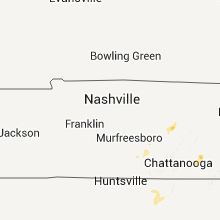
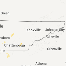
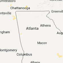

Cities Most Affected by Hail Storms of 9/22/2011
| Hail Size | Demographics of Zip Codes Affected | ||||||
|---|---|---|---|---|---|---|---|
| City | Count | Average | Largest | Pop Density | House Value | Income | Age |
| Denham Springs, LA | 1 | 1.75 | 1.75 | 610 | $98k | $40.8k | 33.3 |
Hail and Wind Damage Spotted on 9/22/2011
Filter by Report Type:Hail ReportsWind Reports
Tennessee
| Local Time | Report Details |
|---|---|
| 8:30 PM UTC | Tree fell on a house. reported by dispatc in bradley county TN, 35.3 miles ENE of Chattanooga, TN |
| 8:30 PM UTC | Dispatch reported trees down at 3187 candies creek ridge road...mcpherson road...8011 eureka road northwest...and moore circle road northwes in bradley county TN, 30.9 miles ENE of Chattanooga, TN |
Arkansas
| Local Time | Report Details |
|---|---|
| 9:12 PM UTC | Power pole down and power out hwy 29 north of lewisville in lafayette county AR, 38.2 miles SSE of Nashville, AR |
| 9:23 PM UTC | Trees blocking hwy 82 west of magnolia in columbia county AR, 56.6 miles SE of Nashville, AR |
| 12:20 AM UTC | Trees down. reported by ashley s. in ashley county AR, 39.6 miles NE of Bastrop, LA |
| 1:00 AM UTC | Tree on a house. reported by chicot s. in chicot county AR, 44.8 miles ENE of Bastrop, LA |
| 1:00 AM UTC | Trees across road in chicot county AR, 44.8 miles ENE of Bastrop, LA |
Louisiana
| Local Time | Report Details |
|---|---|
| 5:00 PM CDT | Golf Ball sized hail reported near Denham Springs, LA, 63.6 miles NW of New Orleans, LA, golfball size hail was reported south of denham springs. |
| 10:05 PM UTC | A tree was blown donw on a house on dabney stree in livingston county LA, 64 miles NW of New Orleans, LA |
| 10:05 PM UTC | A tree was blown down across highway 190 between jubin road and edin church roa in livingston county LA, 64 miles NW of New Orleans, LA |
| 10:10 PM UTC | A tree was blown down on a house on burgess avenu in livingston county LA, 59.7 miles NW of New Orleans, LA |
| 5:10 PM CDT | Quarter sized hail reported near Walker, LA, 59.7 miles NW of New Orleans, LA, quarter size hail was observed. |
| 10:38 PM UTC | Numerous trees dow in union county LA, 41.4 miles WNW of Bastrop, LA |
Georgia
| Local Time | Report Details |
|---|---|
| 10:50 PM UTC | Forysth county emegency management relayed report of a tree downed along bettis tribble gap road. power outages were also reported in the silver city are in forsyth county GA, 36.8 miles NNE of Atlanta, GA |
| 10:50 PM UTC | Location just west of silver city. 5 trees down. 1 down on house. 3 of them were snapped in half. a power pole was snappe in forsyth county GA, 42 miles NNE of Atlanta, GA |
California
| Local Time | Report Details |
|---|---|
| 11:02 PM UTC | At 4 in san bernardino county CA, 39 miles E of Los Angeles, CA |
Mississippi
| Local Time | Report Details |
|---|---|
| 1:35 AM UTC | Downed trees in the cemetery and on poplar and oak street in washington county MS, 69 miles ENE of Bastrop, LA |
Connect with Interactive Hail Maps