

Hail Map for Alder, MT
The Alder, MT area has had 0 reports of on-the-ground hail by trained spotters, and has been under severe weather warnings 1 time during the past 12 months. Doppler radar has detected hail at or near Alder, MT on 1 occasion.
| Name: | Alder, MT |
| Where Located: | 57.9 miles WSW of Bozeman, MT |
| Map: | Google Map for Alder, MT |
| Population: | 103 |
| Housing Units: | 89 |
| More Info: | Search Google for Alder, MT |
0
The Top Recent Hail Date for Alder, MT is Monday, July 10, 2017 (1st out of 1)
Hail and Wind Damage Spotted near Alder, MT
| Date / Time | Report Details |
|---|---|
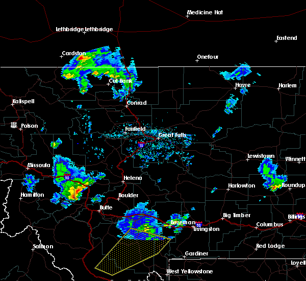
| 8/29/2023 7:03 PM MDT |
 At 702 pm mdt, severe thunderstorms were located along a line extending from 13 miles southeast of dillon to 15 miles northeast of monida to 9 miles northeast of spencer, moving northeast at 30 mph (radar indicated). Hazards include 60 mph wind gusts. expect damage to roofs, siding, and trees At 702 pm mdt, severe thunderstorms were located along a line extending from 13 miles southeast of dillon to 15 miles northeast of monida to 9 miles northeast of spencer, moving northeast at 30 mph (radar indicated). Hazards include 60 mph wind gusts. expect damage to roofs, siding, and trees
|
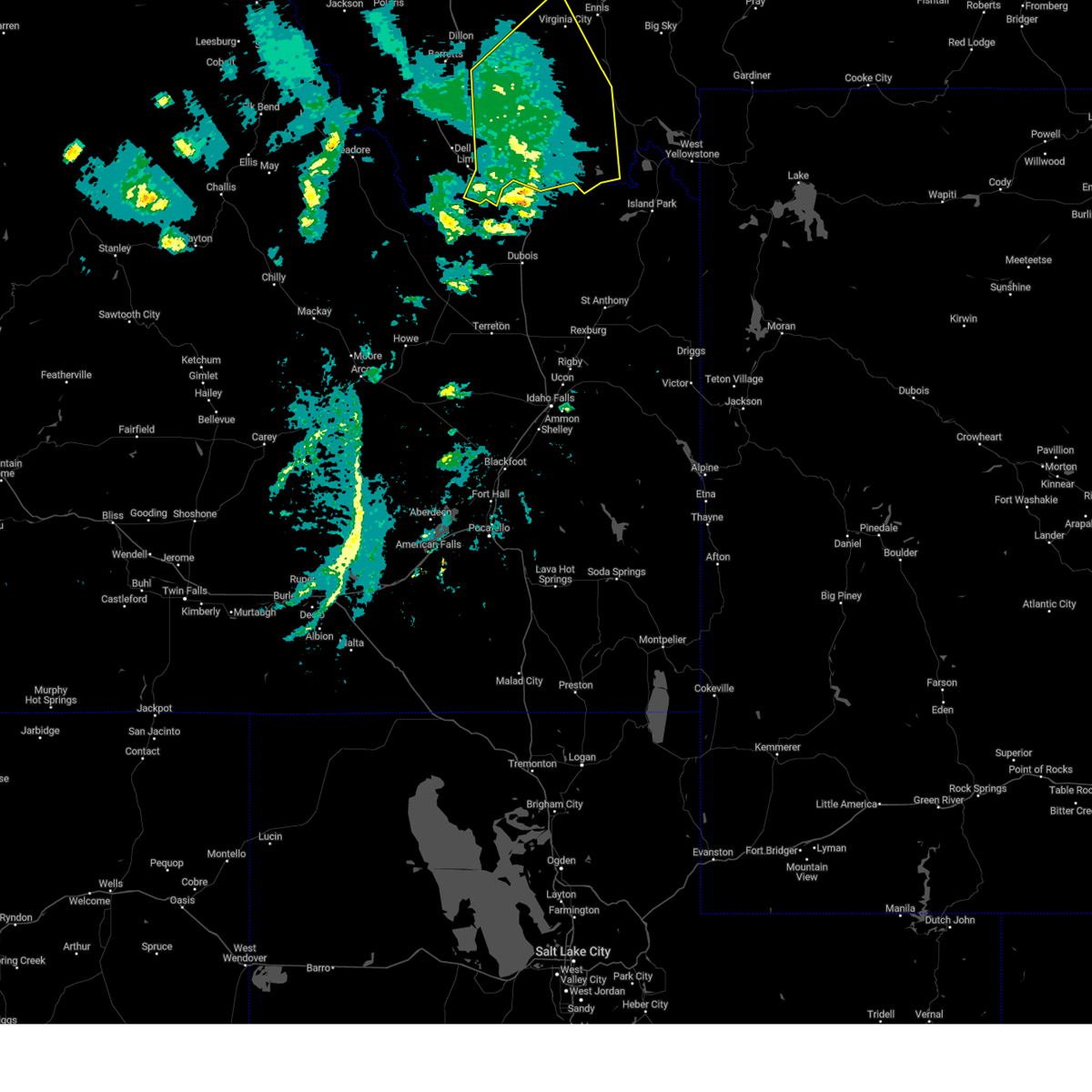
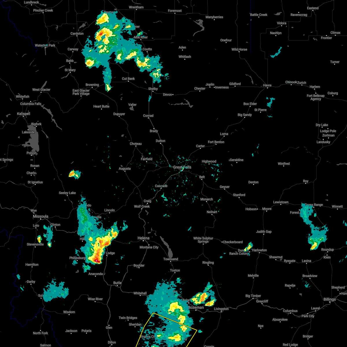
| 7/13/2022 4:44 PM MDT |
 At 443 pm mdt, severe thunderstorms were located along a line extending from 19 miles northeast of ennis to near virginia city, moving northeast at 35 mph (radar indicated). Hazards include 60 mph wind gusts. Expect damage to roofs, siding, and trees. locations impacted include, virginia city, ennis, alder, harrison, pony, norris, mcallister, jeffers, laurin and cameron. hail threat, radar indicated max hail size, <. 75 in wind threat, radar indicated max wind gust, 60 mph. At 443 pm mdt, severe thunderstorms were located along a line extending from 19 miles northeast of ennis to near virginia city, moving northeast at 35 mph (radar indicated). Hazards include 60 mph wind gusts. Expect damage to roofs, siding, and trees. locations impacted include, virginia city, ennis, alder, harrison, pony, norris, mcallister, jeffers, laurin and cameron. hail threat, radar indicated max hail size, <. 75 in wind threat, radar indicated max wind gust, 60 mph.
|
| 7/13/2022 4:39 PM MDT |
 At 439 pm mdt, severe thunderstorms were located along a line extending from 19 miles northeast of ennis to 7 miles south of virginia city, moving northeast at 35 mph (radar indicated). Hazards include 60 mph wind gusts. Expect damage to roofs, siding, and trees. locations impacted include, virginia city, ennis, alder, harrison, pony, norris, mcallister, jeffers, laurin and cameron. hail threat, radar indicated max hail size, <. 75 in wind threat, radar indicated max wind gust, 60 mph. At 439 pm mdt, severe thunderstorms were located along a line extending from 19 miles northeast of ennis to 7 miles south of virginia city, moving northeast at 35 mph (radar indicated). Hazards include 60 mph wind gusts. Expect damage to roofs, siding, and trees. locations impacted include, virginia city, ennis, alder, harrison, pony, norris, mcallister, jeffers, laurin and cameron. hail threat, radar indicated max hail size, <. 75 in wind threat, radar indicated max wind gust, 60 mph.
|
| 7/13/2022 4:29 PM MDT |
 At 429 pm mdt, severe thunderstorms were located along a line extending from 15 miles northeast of ennis to 9 miles southwest of virginia city, moving northeast at 35 mph (radar indicated). Hazards include 60 mph wind gusts. Expect damage to roofs, siding, and trees. locations impacted include, virginia city, ennis, alder, harrison, pony, norris, mcallister, jeffers, laurin and cameron. hail threat, radar indicated max hail size, <. 75 in wind threat, radar indicated max wind gust, 60 mph. At 429 pm mdt, severe thunderstorms were located along a line extending from 15 miles northeast of ennis to 9 miles southwest of virginia city, moving northeast at 35 mph (radar indicated). Hazards include 60 mph wind gusts. Expect damage to roofs, siding, and trees. locations impacted include, virginia city, ennis, alder, harrison, pony, norris, mcallister, jeffers, laurin and cameron. hail threat, radar indicated max hail size, <. 75 in wind threat, radar indicated max wind gust, 60 mph.
|
| 7/13/2022 4:12 PM MDT |
 At 411 pm mdt, a severe thunderstorm was located 13 miles south of alder, or 13 miles southwest of virginia city, moving northeast at 30 mph (radar indicated). Hazards include 60 mph wind gusts and penny size hail. expect damage to roofs, siding, and trees At 411 pm mdt, a severe thunderstorm was located 13 miles south of alder, or 13 miles southwest of virginia city, moving northeast at 30 mph (radar indicated). Hazards include 60 mph wind gusts and penny size hail. expect damage to roofs, siding, and trees
|
| 7/13/2022 2:03 PM MDT |
 At 202 pm mdt, a severe thunderstorm was located near dillon, moving northeast at 35 mph. wind gusts to 60 mph have been observed with this storm (trained weather spotters). Hazards include 60 mph wind gusts and penny size hail. expect damage to roofs, siding, and trees At 202 pm mdt, a severe thunderstorm was located near dillon, moving northeast at 35 mph. wind gusts to 60 mph have been observed with this storm (trained weather spotters). Hazards include 60 mph wind gusts and penny size hail. expect damage to roofs, siding, and trees
|
| 6/28/2022 2:23 PM MDT |
 The severe thunderstorm warning for northwestern madison and north central beaverhead counties will expire at 230 pm mdt, the storm which prompted the warning has weakened below severe limits, and no longer poses an immediate threat to life or property. therefore, the warning will be allowed to expire. however gusty winds are still possible with this thunderstorm. The severe thunderstorm warning for northwestern madison and north central beaverhead counties will expire at 230 pm mdt, the storm which prompted the warning has weakened below severe limits, and no longer poses an immediate threat to life or property. therefore, the warning will be allowed to expire. however gusty winds are still possible with this thunderstorm.
|
| 6/28/2022 1:58 PM MDT |
 At 158 pm mdt, a severe thunderstorm was located 13 miles south of twin bridges, or 13 miles southwest of sheridan, moving northeast at 40 mph (radar indicated). Hazards include 60 mph wind gusts. expect damage to roofs, siding, and trees At 158 pm mdt, a severe thunderstorm was located 13 miles south of twin bridges, or 13 miles southwest of sheridan, moving northeast at 40 mph (radar indicated). Hazards include 60 mph wind gusts. expect damage to roofs, siding, and trees
|
| 9/10/2021 6:58 PM MDT |
 The severe thunderstorm warning for madison, central beaverhead and south central gallatin counties will expire at 700 pm mdt, the storms which prompted the warning have weakened below severe limits, and have exited the warned area. therefore, the warning will be allowed to expire. however gusty winds are still possible with these thunderstorms. to report severe weather, contact your nearest law enforcement agency. they will relay your report to the national weather service great falls. The severe thunderstorm warning for madison, central beaverhead and south central gallatin counties will expire at 700 pm mdt, the storms which prompted the warning have weakened below severe limits, and have exited the warned area. therefore, the warning will be allowed to expire. however gusty winds are still possible with these thunderstorms. to report severe weather, contact your nearest law enforcement agency. they will relay your report to the national weather service great falls.
|
| 9/10/2021 6:38 PM MDT |
 At 636 pm mdt, severe thunderstorms were located along a line extending from 24 miles north of wisdom to near harlequin lake, moving northeast at 50 mph (radar indicated. at 611 pm mdt, a 63 mph wind gust was reported at the dillon airport). Hazards include 70 mph wind gusts. Expect considerable tree damage. damage is likely to mobile homes, roofs, and outbuildings. blowing dust and smoke will also reduce visibility. locations impacted include, dillon, west yellowstone, sheridan, virginia city, ennis, twin bridges, pony, wisdom, alder, divide lake, silver star, west entrance, big sky, melrose, wise river, dewey, targhee pass, cameron, waterloo and glen. thunderstorm damage threat, considerable hail threat, radar indicated max hail size, <. 75 in wind threat, observed max wind gust, 70 mph. At 636 pm mdt, severe thunderstorms were located along a line extending from 24 miles north of wisdom to near harlequin lake, moving northeast at 50 mph (radar indicated. at 611 pm mdt, a 63 mph wind gust was reported at the dillon airport). Hazards include 70 mph wind gusts. Expect considerable tree damage. damage is likely to mobile homes, roofs, and outbuildings. blowing dust and smoke will also reduce visibility. locations impacted include, dillon, west yellowstone, sheridan, virginia city, ennis, twin bridges, pony, wisdom, alder, divide lake, silver star, west entrance, big sky, melrose, wise river, dewey, targhee pass, cameron, waterloo and glen. thunderstorm damage threat, considerable hail threat, radar indicated max hail size, <. 75 in wind threat, observed max wind gust, 70 mph.
|
| 9/10/2021 6:12 PM MDT |
 At 612 pm mdt, severe thunderstorms were located along a line extending from 16 miles southeast of conner to near island park village, moving northeast at 50 mph (radar indicated). Hazards include 70 mph wind gusts. Expect considerable tree damage. Damage is likely to mobile homes, roofs, and outbuildings. At 612 pm mdt, severe thunderstorms were located along a line extending from 16 miles southeast of conner to near island park village, moving northeast at 50 mph (radar indicated). Hazards include 70 mph wind gusts. Expect considerable tree damage. Damage is likely to mobile homes, roofs, and outbuildings.
|
| 8/8/2021 5:04 PM MDT |
 At 501 pm mdt, sporadic areas of severe wind gusts continue across the warned area. many locations within the warned area have reported wind gusts of 50 to 55 mph over the last 30 minutes. a few gusts to around 60 mph are likely (trained weather spotters). Hazards include 60 mph wind gusts. Expect damage to roofs, siding, and trees. locations impacted include, bozeman, dillon, sheridan, virginia city, belgrade, three forks, manhattan, ennis, lima, pony, alder, harrison, dell, bannack pass, cameron, missouri headwaters state park, snowline, maudlow, four corners and amsterdam. hail threat, radar indicated max hail size, <. 75 in wind threat, radar indicated max wind gust, 60 mph. At 501 pm mdt, sporadic areas of severe wind gusts continue across the warned area. many locations within the warned area have reported wind gusts of 50 to 55 mph over the last 30 minutes. a few gusts to around 60 mph are likely (trained weather spotters). Hazards include 60 mph wind gusts. Expect damage to roofs, siding, and trees. locations impacted include, bozeman, dillon, sheridan, virginia city, belgrade, three forks, manhattan, ennis, lima, pony, alder, harrison, dell, bannack pass, cameron, missouri headwaters state park, snowline, maudlow, four corners and amsterdam. hail threat, radar indicated max hail size, <. 75 in wind threat, radar indicated max wind gust, 60 mph.
|
| 8/8/2021 4:29 PM MDT |
 At 429 pm mdt, areas of severe wind gusts were located along a line extending from 11 miles southeast of toston to 6 miles north of leadore, moving northeast at 45 mph (radar indicated). Hazards include 60 mph wind gusts. expect damage to roofs, siding, and trees At 429 pm mdt, areas of severe wind gusts were located along a line extending from 11 miles southeast of toston to 6 miles north of leadore, moving northeast at 45 mph (radar indicated). Hazards include 60 mph wind gusts. expect damage to roofs, siding, and trees
|
| 7/29/2021 5:54 PM MDT |
 The severe thunderstorm warning for central madison county will expire at 600 pm mdt, the storm which prompted the warning has weakened below severe limits, and no longer poses an immediate threat to life or property. therefore, the warning will be allowed to expire. however gusty winds of 40 to 50 mph are still possible with this thunderstorm. to report severe weather, contact your nearest law enforcement agency. they will relay your report to the national weather service great falls. The severe thunderstorm warning for central madison county will expire at 600 pm mdt, the storm which prompted the warning has weakened below severe limits, and no longer poses an immediate threat to life or property. therefore, the warning will be allowed to expire. however gusty winds of 40 to 50 mph are still possible with this thunderstorm. to report severe weather, contact your nearest law enforcement agency. they will relay your report to the national weather service great falls.
|
| 7/29/2021 5:38 PM MDT |
 At 537 pm mdt, a severe thunderstorm was located near virginia city, moving east at 20 mph (satellite indicated). Hazards include 60 mph wind gusts. Expect damage to roofs, siding, and trees. Locations impacted include, virginia city, alder and laurin. At 537 pm mdt, a severe thunderstorm was located near virginia city, moving east at 20 mph (satellite indicated). Hazards include 60 mph wind gusts. Expect damage to roofs, siding, and trees. Locations impacted include, virginia city, alder and laurin.
|
| 7/29/2021 5:19 PM MDT |
 At 518 pm mdt, a severe thunderstorm was located 7 miles south of alder, or 8 miles southwest of virginia city, moving east at 20 mph (satellite indicated). Hazards include 60 mph wind gusts. expect damage to roofs, siding, and trees At 518 pm mdt, a severe thunderstorm was located 7 miles south of alder, or 8 miles southwest of virginia city, moving east at 20 mph (satellite indicated). Hazards include 60 mph wind gusts. expect damage to roofs, siding, and trees
|
| 8/11/2019 3:06 PM MDT |
 The severe thunderstorm warning for central madison county will expire at 315 pm mdt, the storm which prompted the warning has weakened below severe limits, and has exited the warned area. therefore, the warning will be allowed to expire. a severe thunderstorm watch remains in effect until 700 pm mdt for southwestern montana. The severe thunderstorm warning for central madison county will expire at 315 pm mdt, the storm which prompted the warning has weakened below severe limits, and has exited the warned area. therefore, the warning will be allowed to expire. a severe thunderstorm watch remains in effect until 700 pm mdt for southwestern montana.
|
| 8/11/2019 2:50 PM MDT |
 At 249 pm mdt, a severe thunderstorm was located near alder, or near sheridan, moving northeast at 40 mph (radar indicated). Hazards include 60 mph wind gusts and quarter size hail. Hail damage to vehicles is expected. expect wind damage to roofs, siding, and trees. Locations impacted include, sheridan, ennis, alder and laurin. At 249 pm mdt, a severe thunderstorm was located near alder, or near sheridan, moving northeast at 40 mph (radar indicated). Hazards include 60 mph wind gusts and quarter size hail. Hail damage to vehicles is expected. expect wind damage to roofs, siding, and trees. Locations impacted include, sheridan, ennis, alder and laurin.
|
| 8/11/2019 2:38 PM MDT |
 The severe thunderstorm warning for west central madison and central beaverhead counties will expire at 245 pm mdt, the storms which prompted the warning have moved out of the area. a severe thunderstorm warning still remains in effect for west central beaverhead county. The severe thunderstorm warning for west central madison and central beaverhead counties will expire at 245 pm mdt, the storms which prompted the warning have moved out of the area. a severe thunderstorm warning still remains in effect for west central beaverhead county.
|
| 8/11/2019 2:37 PM MDT |
 At 237 pm mdt, a severe thunderstorm was located 12 miles west of alder, or 14 miles southwest of sheridan, moving northeast at 40 mph (radar indicated). Hazards include 60 mph wind gusts and quarter size hail. Hail damage to vehicles is expected. Expect wind damage to roofs, siding, and trees. At 237 pm mdt, a severe thunderstorm was located 12 miles west of alder, or 14 miles southwest of sheridan, moving northeast at 40 mph (radar indicated). Hazards include 60 mph wind gusts and quarter size hail. Hail damage to vehicles is expected. Expect wind damage to roofs, siding, and trees.
|
| 8/11/2019 2:27 PM MDT |
 At 207 pm mdt, severe thunderstorms were located along a line extending from 29 miles southwest of twin bridges to 7 miles south of dillon, moving northeast at 40 mph (radar indicated). Hazards include 60 mph wind gusts and nickel size hail. expect damage to roofs, siding, and trees At 207 pm mdt, severe thunderstorms were located along a line extending from 29 miles southwest of twin bridges to 7 miles south of dillon, moving northeast at 40 mph (radar indicated). Hazards include 60 mph wind gusts and nickel size hail. expect damage to roofs, siding, and trees
|
| 8/11/2019 2:07 PM MDT |
 At 207 pm mdt, severe thunderstorms were located along a line extending from 29 miles southwest of twin bridges to 7 miles south of dillon, moving northeast at 40 mph (radar indicated). Hazards include 60 mph wind gusts and nickel size hail. expect damage to roofs, siding, and trees At 207 pm mdt, severe thunderstorms were located along a line extending from 29 miles southwest of twin bridges to 7 miles south of dillon, moving northeast at 40 mph (radar indicated). Hazards include 60 mph wind gusts and nickel size hail. expect damage to roofs, siding, and trees
|
| 7/7/2019 4:12 PM MDT |
 The severe thunderstorm warning for northeastern madison and central gallatin counties will expire at 415 pm mdt, the severe thunderstorm which prompted the warning has weakened. therefore, the warning will be allowed to expire. a severe thunderstorm watch remains in effect until 1000 pm mdt for south central and southwestern montana. The severe thunderstorm warning for northeastern madison and central gallatin counties will expire at 415 pm mdt, the severe thunderstorm which prompted the warning has weakened. therefore, the warning will be allowed to expire. a severe thunderstorm watch remains in effect until 1000 pm mdt for south central and southwestern montana.
|
| 7/7/2019 4:02 PM MDT |
 At 401 pm mdt, a severe thunderstorm was located 11 miles southeast of ennis, or 19 miles east of virginia city, moving northeast at 40 mph. another severe storm was located about 20 miles south of virginia city, also moving northeast at 40 mph (radar indicated). Hazards include 60 mph wind gusts and quarter size hail. Hail damage to vehicles is expected. expect wind damage to roofs, siding, and trees. Locations impacted include, virginia city, ennis, norris, big sky, mcallister, jeffers and cameron. At 401 pm mdt, a severe thunderstorm was located 11 miles southeast of ennis, or 19 miles east of virginia city, moving northeast at 40 mph. another severe storm was located about 20 miles south of virginia city, also moving northeast at 40 mph (radar indicated). Hazards include 60 mph wind gusts and quarter size hail. Hail damage to vehicles is expected. expect wind damage to roofs, siding, and trees. Locations impacted include, virginia city, ennis, norris, big sky, mcallister, jeffers and cameron.
|
| 7/7/2019 3:43 PM MDT |
 The severe thunderstorm warning for southeastern madison and southeastern beaverhead counties will expire at 345 pm mdt, the storms which prompted the warning have moved out of the area. therefore, the warning will be allowed to expire and has been replaced by a new warning in effect until 4:15 pm mdt this afternoon. a severe thunderstorm watch remains in effect until 1000 pm mdt for southwestern montana. The severe thunderstorm warning for southeastern madison and southeastern beaverhead counties will expire at 345 pm mdt, the storms which prompted the warning have moved out of the area. therefore, the warning will be allowed to expire and has been replaced by a new warning in effect until 4:15 pm mdt this afternoon. a severe thunderstorm watch remains in effect until 1000 pm mdt for southwestern montana.
|
| 7/7/2019 3:41 PM MDT |
 At 340 pm mdt, a severe thunderstorm was located 22 miles south of virginia city, moving northeast at 35 mph. other severe storms were located near dell and cameron, also moving northeast at 35 mph (radar indicated). Hazards include 60 mph wind gusts and quarter size hail. Hail damage to vehicles is expected. Expect wind damage to roofs, siding, and trees. At 340 pm mdt, a severe thunderstorm was located 22 miles south of virginia city, moving northeast at 35 mph. other severe storms were located near dell and cameron, also moving northeast at 35 mph (radar indicated). Hazards include 60 mph wind gusts and quarter size hail. Hail damage to vehicles is expected. Expect wind damage to roofs, siding, and trees.
|
| 7/7/2019 3:31 PM MDT |
 At 329 pm mdt, severe thunderstorms were located along a line extending from 17 miles southwest of virginia city to near lima, moving northeast at 20 mph (radar indicated). Hazards include 60 mph wind gusts and quarter size hail. Hail damage to vehicles is expected. expect wind damage to roofs, siding, and trees. Locations impacted include, virginia city and cameron. At 329 pm mdt, severe thunderstorms were located along a line extending from 17 miles southwest of virginia city to near lima, moving northeast at 20 mph (radar indicated). Hazards include 60 mph wind gusts and quarter size hail. Hail damage to vehicles is expected. expect wind damage to roofs, siding, and trees. Locations impacted include, virginia city and cameron.
|
| 7/7/2019 3:13 PM MDT |
 At 312 pm mdt, severe thunderstorms were located along a line extending from 21 miles south of alder to near lima, moving northeast at 25 mph (spotter reported quarter-size hail in lima recently). Hazards include 60 mph wind gusts and quarter size hail. Hail damage to vehicles is expected. Expect wind damage to roofs, siding, and trees. At 312 pm mdt, severe thunderstorms were located along a line extending from 21 miles south of alder to near lima, moving northeast at 25 mph (spotter reported quarter-size hail in lima recently). Hazards include 60 mph wind gusts and quarter size hail. Hail damage to vehicles is expected. Expect wind damage to roofs, siding, and trees.
|
| 6/21/2018 2:43 PM MDT | Burnt creek raw in madison county MT, 26.7 miles NNW of Alder, MT |
| 7/17/2013 5:40 PM MDT | One half inch diameter hail remained after storm moved through the area 20 miles south of alder. some melting possible. nearby hills still white due to hail covering th in madison county MT, 20.1 miles N of Alder, MT |
| 10/16/2012 10:00 AM MDT | Report of numerous trees down...montana state highway 287 between sheridan and alder was closed from approximately 1030 am to 1230 pm in madison county MT, 5.6 miles SE of Alder, MT |
Hail Maps for Alder, MT

Connect with Interactive Hail Maps