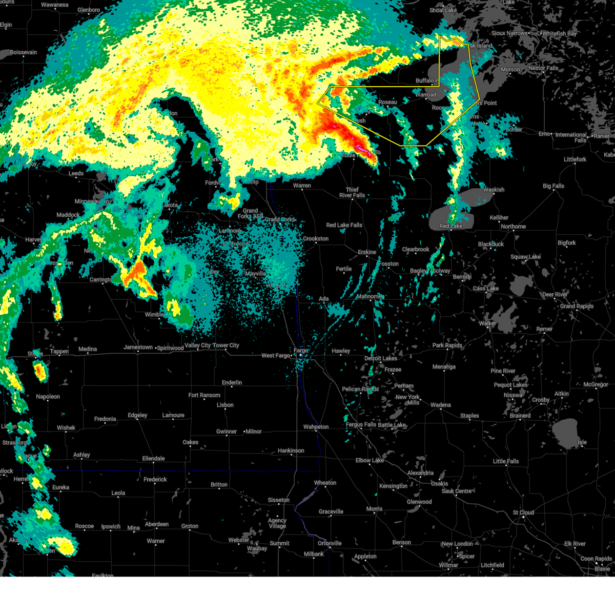
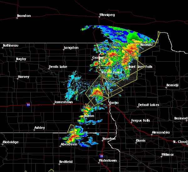
| 9/5/2023 2:37 AM CDT |
 The severe thunderstorm warning for northeastern roseau and northwestern lake of the woods counties will expire at 245 am cdt, the storm which prompted the warning has weakened below severe limits, and no longer poses an immediate threat to life or property. therefore, the warning will be allowed to expire. a severe thunderstorm watch remains in effect until 300 am cdt for north central and northwestern minnesota. The severe thunderstorm warning for northeastern roseau and northwestern lake of the woods counties will expire at 245 am cdt, the storm which prompted the warning has weakened below severe limits, and no longer poses an immediate threat to life or property. therefore, the warning will be allowed to expire. a severe thunderstorm watch remains in effect until 300 am cdt for north central and northwestern minnesota.
|
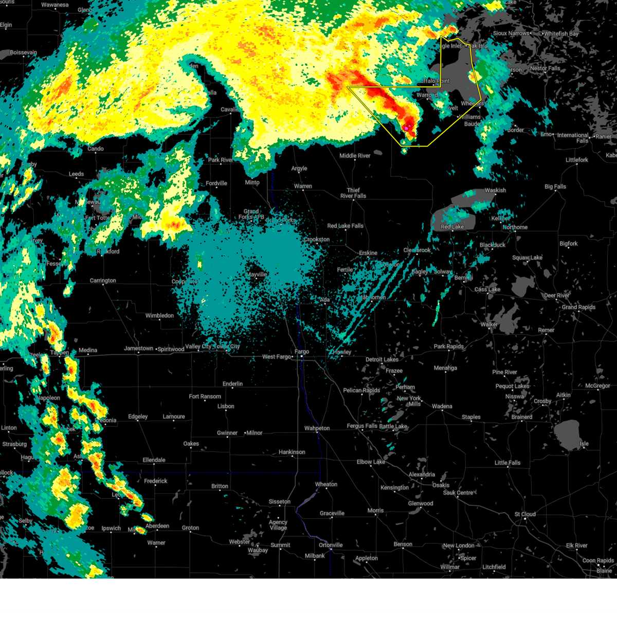
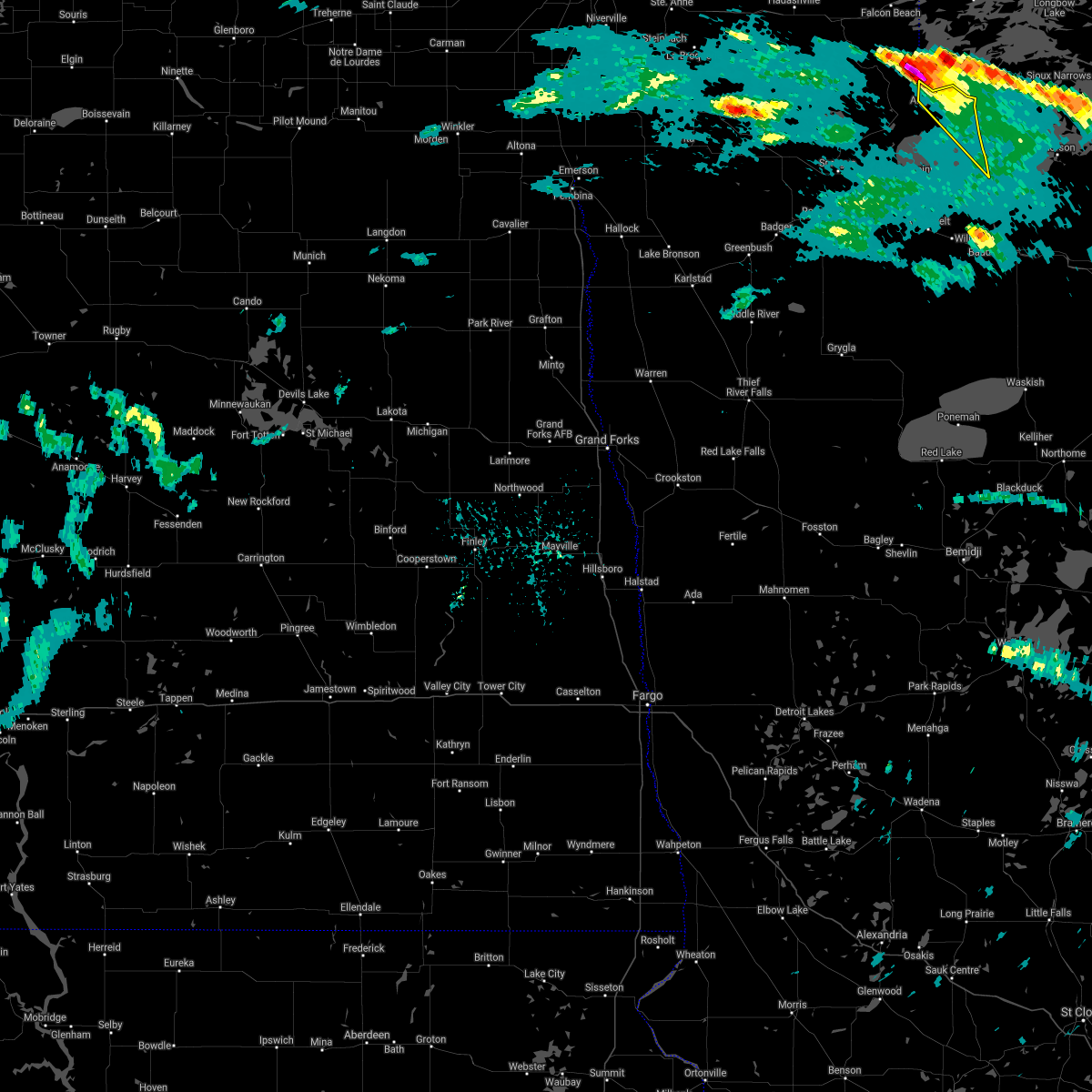
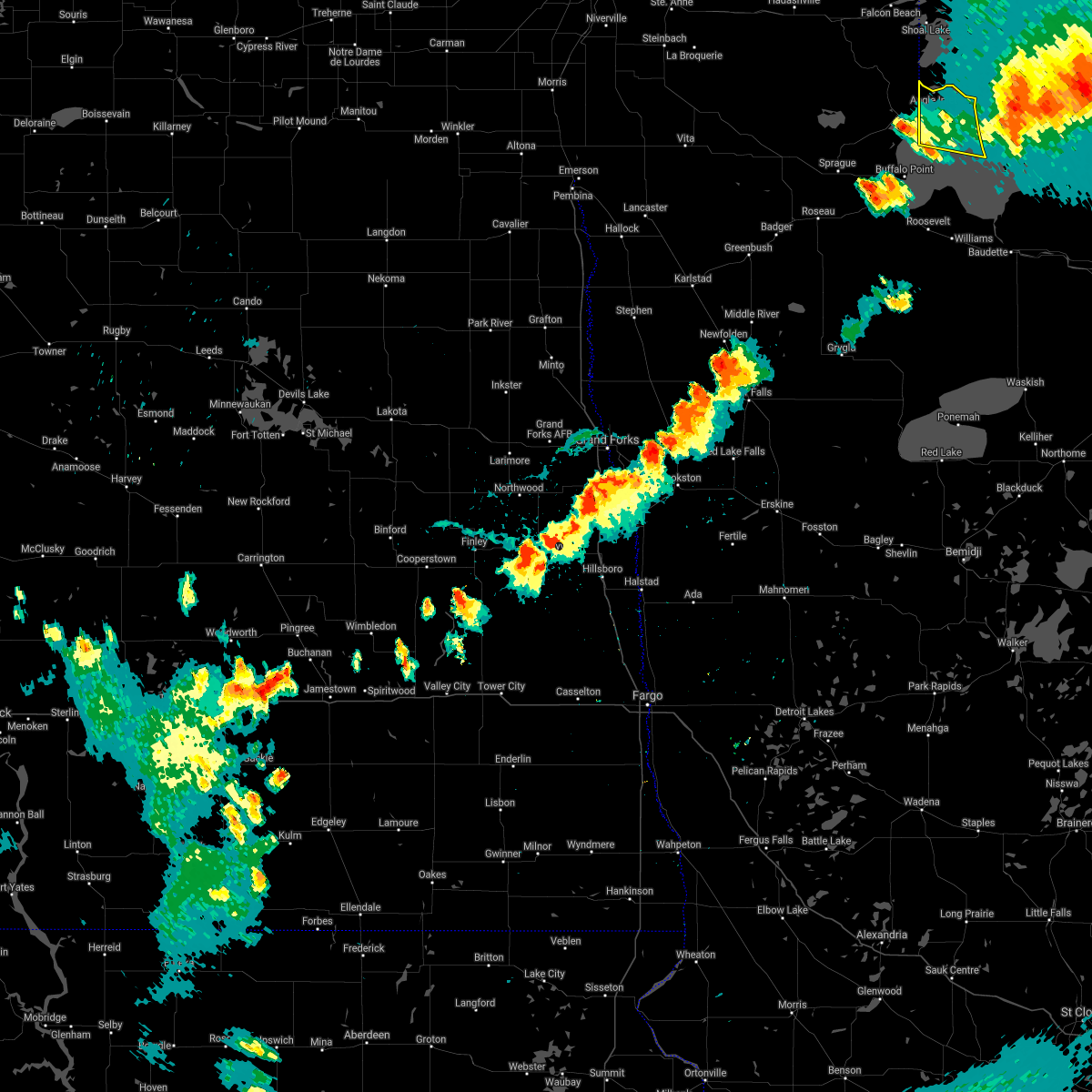
| 9/5/2023 2:30 AM CDT |
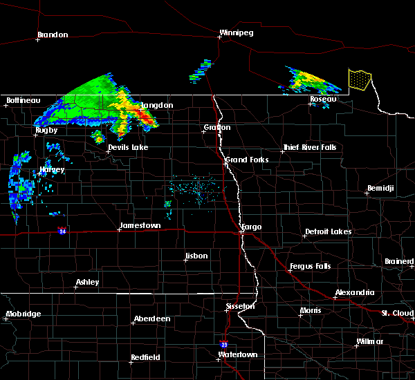
 At 230 am cdt, a severe thunderstorm was located near swift, or 22 miles east of roseau, moving northeast at 60 mph (radar indicated). Hazards include 60 mph wind gusts and quarter size hail. Hail damage to vehicles is expected. expect wind damage to roofs, siding, and trees. locations impacted include, warroad, arnesen, springsteel island, williams, angle inlet, roosevelt and lude. hail threat, radar indicated max hail size, 1. 00 in wind threat, observed max wind gust, 60 mph. At 230 am cdt, a severe thunderstorm was located near swift, or 22 miles east of roseau, moving northeast at 60 mph (radar indicated). Hazards include 60 mph wind gusts and quarter size hail. Hail damage to vehicles is expected. expect wind damage to roofs, siding, and trees. locations impacted include, warroad, arnesen, springsteel island, williams, angle inlet, roosevelt and lude. hail threat, radar indicated max hail size, 1. 00 in wind threat, observed max wind gust, 60 mph.
|
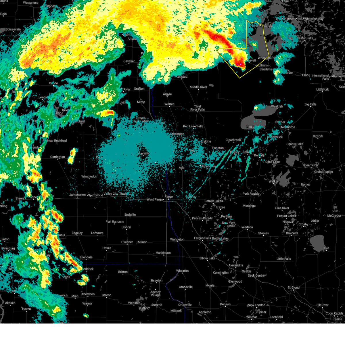
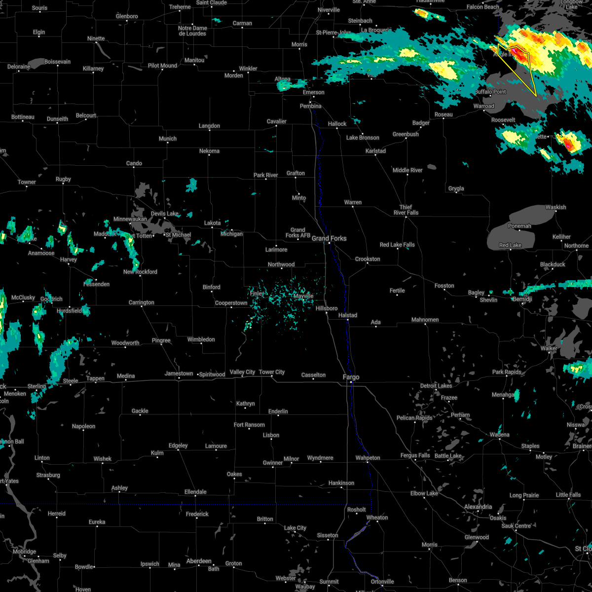
| 9/5/2023 2:18 AM CDT |
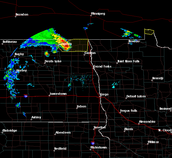
 At 218 am cdt, severe thunderstorms were located along a line extending from 10 miles north of pinecreek to near warroad to 7 miles east of hayes lake state park, moving northeast at 65 mph (radar indicated). Hazards include 70 mph wind gusts and quarter size hail. Hail damage to vehicles is expected. expect considerable tree damage. wind damage is also likely to mobile homes, roofs, and outbuildings. locations impacted include, roseau, warroad, arnesen, springsteel island, williams, angle inlet and roosevelt. thunderstorm damage threat, considerable hail threat, radar indicated max hail size, 1. 00 in wind threat, observed max wind gust, 70 mph. At 218 am cdt, severe thunderstorms were located along a line extending from 10 miles north of pinecreek to near warroad to 7 miles east of hayes lake state park, moving northeast at 65 mph (radar indicated). Hazards include 70 mph wind gusts and quarter size hail. Hail damage to vehicles is expected. expect considerable tree damage. wind damage is also likely to mobile homes, roofs, and outbuildings. locations impacted include, roseau, warroad, arnesen, springsteel island, williams, angle inlet and roosevelt. thunderstorm damage threat, considerable hail threat, radar indicated max hail size, 1. 00 in wind threat, observed max wind gust, 70 mph.
|
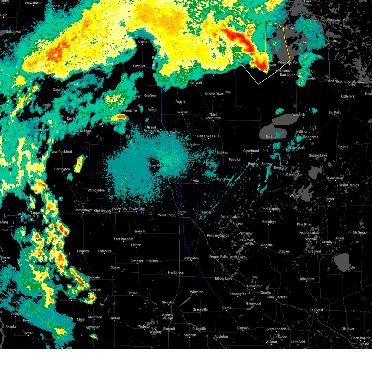
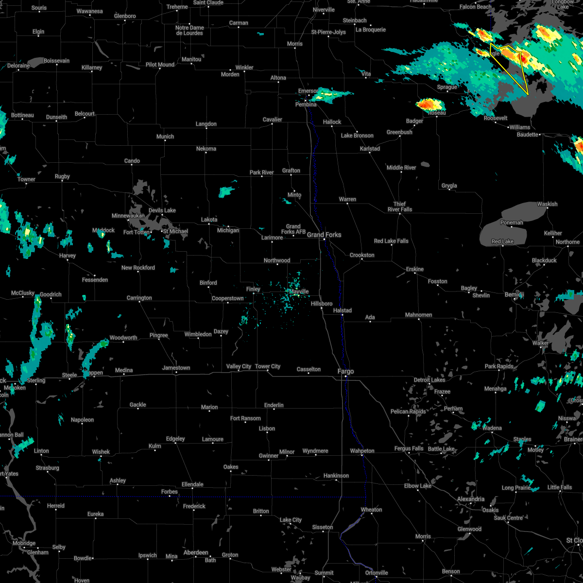
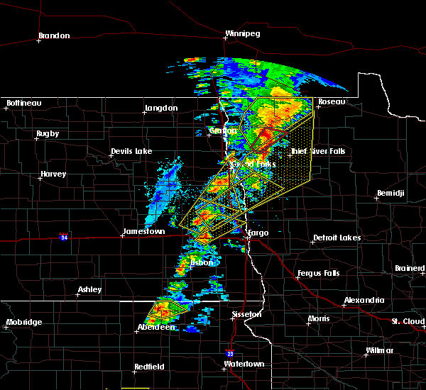
| 9/5/2023 1:49 AM CDT |
 At 148 am cdt, severe thunderstorms were located along a line extending from 7 miles north of lake bronson state park to near badger to gatzke, moving northeast at 65 mph. this storm has a history of producing up to 80 mph winds! these are destructive storms for the roseau area! (radar indicated). Hazards include 80 mph wind gusts. Flying debris will be dangerous to those caught without shelter. mobile homes will be heavily damaged. expect considerable damage to roofs, windows, and vehicles. Extensive tree damage and power outages are likely. At 148 am cdt, severe thunderstorms were located along a line extending from 7 miles north of lake bronson state park to near badger to gatzke, moving northeast at 65 mph. this storm has a history of producing up to 80 mph winds! these are destructive storms for the roseau area! (radar indicated). Hazards include 80 mph wind gusts. Flying debris will be dangerous to those caught without shelter. mobile homes will be heavily damaged. expect considerable damage to roofs, windows, and vehicles. Extensive tree damage and power outages are likely.
|
| 7/28/2021 12:06 PM CDT |
 The severe thunderstorm warning for north central lake of the woods county will expire at 1215 pm cdt, the storm which prompted the warning has moved out of the area. therefore, the warning will be allowed to expire. however small hail is still possible from nearby thunderstorms. to report severe weather, contact your nearest law enforcement agency. they will relay your report to the national weather service grand forks. The severe thunderstorm warning for north central lake of the woods county will expire at 1215 pm cdt, the storm which prompted the warning has moved out of the area. therefore, the warning will be allowed to expire. however small hail is still possible from nearby thunderstorms. to report severe weather, contact your nearest law enforcement agency. they will relay your report to the national weather service grand forks.
|
| 7/28/2021 11:46 AM CDT |
 At 1146 am cdt, a severe thunderstorm was located over oak island, or 52 miles northeast of roseau, moving southeast at 35 mph (radar indicated). Hazards include ping pong ball size hail and 60 mph wind gusts. People and animals outdoors will be injured. expect hail damage to roofs, siding, windows, and vehicles. expect wind damage to roofs, siding, and trees. This severe thunderstorm will remain over mainly rural areas of north central lake of the woods county. At 1146 am cdt, a severe thunderstorm was located over oak island, or 52 miles northeast of roseau, moving southeast at 35 mph (radar indicated). Hazards include ping pong ball size hail and 60 mph wind gusts. People and animals outdoors will be injured. expect hail damage to roofs, siding, windows, and vehicles. expect wind damage to roofs, siding, and trees. This severe thunderstorm will remain over mainly rural areas of north central lake of the woods county.
|
| 7/28/2021 11:40 AM CDT |
Quarter sized hail reported 4.2 miles W of Angle Inlet, MN, hail brushed the northwest angle of minnesota across to oak islandbetwen 1130 and 1150 am. most hail ranged from pea to dime sized. some up to quarter sized fell near t
|
| 7/28/2021 11:40 AM CDT |
Quarter sized hail reported 3.8 miles W of Angle Inlet, MN, hail brushed the northwest angle of minnesota across to oak islandbetwen 1130 and 1150 am. most hail ranged from pea to dime sized. some up to quarter sized fell near t
|
| 7/28/2021 11:20 AM CDT |
 At 1120 am cdt, a severe thunderstorm was located near angle inlet, or 47 miles northeast of roseau, moving southeast at 35 mph (radar indicated). Hazards include two inch hail and 60 mph wind gusts. People and animals outdoors will be injured. expect hail damage to roofs, siding, windows, and vehicles. expect wind damage to roofs, siding, and trees. this severe thunderstorm will be near, angle inlet around 1130 am cdt. penasse around 1135 am cdt. flag island around 1140 am cdt. Other locations in the path of this severe thunderstorm include oak island. At 1120 am cdt, a severe thunderstorm was located near angle inlet, or 47 miles northeast of roseau, moving southeast at 35 mph (radar indicated). Hazards include two inch hail and 60 mph wind gusts. People and animals outdoors will be injured. expect hail damage to roofs, siding, windows, and vehicles. expect wind damage to roofs, siding, and trees. this severe thunderstorm will be near, angle inlet around 1130 am cdt. penasse around 1135 am cdt. flag island around 1140 am cdt. Other locations in the path of this severe thunderstorm include oak island.
|
| 6/17/2020 9:35 PM CDT |
 At 935 pm cdt, severe thunderstorms were located along a line extending from near haug to badger to near wannaska, moving northeast at 45 mph (radar indicated). Hazards include 70 mph wind gusts and penny size hail. Expect considerable tree damage. damage is likely to mobile homes, roofs, and outbuildings. Locations impacted include, roseau, warroad, karlstad, greenbush, badger, springsteel island and strandquist. At 935 pm cdt, severe thunderstorms were located along a line extending from near haug to badger to near wannaska, moving northeast at 45 mph (radar indicated). Hazards include 70 mph wind gusts and penny size hail. Expect considerable tree damage. damage is likely to mobile homes, roofs, and outbuildings. Locations impacted include, roseau, warroad, karlstad, greenbush, badger, springsteel island and strandquist.
|
| 6/17/2020 9:02 PM CDT |
 At 901 pm cdt, severe thunderstorms were located along a line extending from 15 miles north of pinecreek to ross to near middle river, moving northeast at 50 mph (radar indicated). Hazards include 70 mph wind gusts and penny size hail. Expect considerable tree damage. Damage is likely to mobile homes, roofs, and outbuildings. At 901 pm cdt, severe thunderstorms were located along a line extending from 15 miles north of pinecreek to ross to near middle river, moving northeast at 50 mph (radar indicated). Hazards include 70 mph wind gusts and penny size hail. Expect considerable tree damage. Damage is likely to mobile homes, roofs, and outbuildings.
|
| 6/8/2020 5:50 PM CDT |
 At 550 pm cdt, a severe thunderstorm was located 14 miles north of longworth, or 32 miles northeast of roseau, moving northeast at 45 mph (radar indicated). Hazards include golf ball size hail and 60 mph wind gusts. People and animals outdoors will be injured. expect hail damage to roofs, siding, windows, and vehicles. expect wind damage to roofs, siding, and trees. this severe thunderstorm will be near, angle inlet around 610 pm cdt. Penasse, flag island and oak island around 615 pm cdt. At 550 pm cdt, a severe thunderstorm was located 14 miles north of longworth, or 32 miles northeast of roseau, moving northeast at 45 mph (radar indicated). Hazards include golf ball size hail and 60 mph wind gusts. People and animals outdoors will be injured. expect hail damage to roofs, siding, windows, and vehicles. expect wind damage to roofs, siding, and trees. this severe thunderstorm will be near, angle inlet around 610 pm cdt. Penasse, flag island and oak island around 615 pm cdt.
|
| 7/15/2019 11:43 AM CDT |
 At 1142 am cdt, severe thunderstorms were located along a line extending from 7 miles southwest of garden island state recreation area to near ponemah, moving east at 40 mph (radar indicated). Hazards include 60 mph wind gusts and quarter size hail. Hail damage to vehicles is expected. Expect wind damage to roofs, siding, and trees. At 1142 am cdt, severe thunderstorms were located along a line extending from 7 miles southwest of garden island state recreation area to near ponemah, moving east at 40 mph (radar indicated). Hazards include 60 mph wind gusts and quarter size hail. Hail damage to vehicles is expected. Expect wind damage to roofs, siding, and trees.
|
| 7/15/2019 11:22 AM CDT |
 At 1121 am cdt, severe thunderstorms were located along a line extending from 7 miles northeast of springsteel island to 7 miles south of thorhult, moving east at 45 mph (radar indicated). Hazards include 60 mph wind gusts and quarter size hail. Hail damage to vehicles is expected. expect wind damage to roofs, siding, and trees. Locations impacted include, warroad, baudette, arnesen, springsteel island, upper red lake, williams and angle inlet. At 1121 am cdt, severe thunderstorms were located along a line extending from 7 miles northeast of springsteel island to 7 miles south of thorhult, moving east at 45 mph (radar indicated). Hazards include 60 mph wind gusts and quarter size hail. Hail damage to vehicles is expected. expect wind damage to roofs, siding, and trees. Locations impacted include, warroad, baudette, arnesen, springsteel island, upper red lake, williams and angle inlet.
|
| 7/15/2019 11:00 AM CDT |
 At 1100 am cdt, severe thunderstorms were located along a line extending from 8 miles west of longworth to 7 miles south of espelie, moving east at 45 mph (radar indicated). Hazards include 60 mph wind gusts and quarter size hail. Hail damage to vehicles is expected. Expect wind damage to roofs, siding, and trees. At 1100 am cdt, severe thunderstorms were located along a line extending from 8 miles west of longworth to 7 miles south of espelie, moving east at 45 mph (radar indicated). Hazards include 60 mph wind gusts and quarter size hail. Hail damage to vehicles is expected. Expect wind damage to roofs, siding, and trees.
|
| 8/26/2018 11:45 PM CDT |
 At 1145 pm cdt, severe thunderstorms were located along a line extending from 12 miles north of pinecreek to carmel, moving east at 45 mph (radar indicated). Hazards include 60 mph wind gusts and quarter size hail. Hail damage to vehicles is expected. expect wind damage to roofs, siding, and trees. severe thunderstorms will be near, jelle and carmel around 1150 pm cdt. fourtown and malcolm around 1155 pm cdt. thorhult around 1200 am cdt. Garden island state recreation area around 1245 am cdt. At 1145 pm cdt, severe thunderstorms were located along a line extending from 12 miles north of pinecreek to carmel, moving east at 45 mph (radar indicated). Hazards include 60 mph wind gusts and quarter size hail. Hail damage to vehicles is expected. expect wind damage to roofs, siding, and trees. severe thunderstorms will be near, jelle and carmel around 1150 pm cdt. fourtown and malcolm around 1155 pm cdt. thorhult around 1200 am cdt. Garden island state recreation area around 1245 am cdt.
|
| 7/4/2017 8:27 PM CDT |
 The severe thunderstorm warning for northwestern lake of the woods county will expire at 830 pm cdt, the storm which prompted the warning has moved out of the area. therefore the warning will be allowed to expire. a severe thunderstorm watch remains in effect until midnight cdt for north central minnesota. The severe thunderstorm warning for northwestern lake of the woods county will expire at 830 pm cdt, the storm which prompted the warning has moved out of the area. therefore the warning will be allowed to expire. a severe thunderstorm watch remains in effect until midnight cdt for north central minnesota.
|
| 7/4/2017 8:01 PM CDT |
 At 801 pm cdt, a severe thunderstorm was located over flag island, or 49 miles northeast of roseau, moving southeast at 40 mph (radar indicated). Hazards include 60 mph wind gusts and quarter size hail. Hail damage to vehicles is expected. expect wind damage to roofs, siding, and trees. Locations impacted include, angle inlet, oak island, flag island and penasse. At 801 pm cdt, a severe thunderstorm was located over flag island, or 49 miles northeast of roseau, moving southeast at 40 mph (radar indicated). Hazards include 60 mph wind gusts and quarter size hail. Hail damage to vehicles is expected. expect wind damage to roofs, siding, and trees. Locations impacted include, angle inlet, oak island, flag island and penasse.
|
| 7/4/2017 7:45 PM CDT |
 At 745 pm cdt, a severe thunderstorm was located near angle inlet, or 41 miles northeast of roseau, moving southeast at 45 mph (radar indicated). Hazards include 60 mph wind gusts and quarter size hail. Hail damage to vehicles is expected. expect wind damage to roofs, siding, and trees. this severe thunderstorm will be near, flag island and penasse around 755 pm cdt. Oak island around 800 pm cdt. At 745 pm cdt, a severe thunderstorm was located near angle inlet, or 41 miles northeast of roseau, moving southeast at 45 mph (radar indicated). Hazards include 60 mph wind gusts and quarter size hail. Hail damage to vehicles is expected. expect wind damage to roofs, siding, and trees. this severe thunderstorm will be near, flag island and penasse around 755 pm cdt. Oak island around 800 pm cdt.
|
| 6/19/2016 6:52 PM CDT |
 At 651 pm cdt, a severe thunderstorm was located near long point, or 38 miles northeast of roseau, moving east at 65 mph (radar indicated). Hazards include ping pong ball size hail. People and animals outdoors will be injured. expect damage to roofs, siding, windows, and vehicles. This severe thunderstorm will remain over mainly rural areas of eastern roseau and northwestern lake of the woods counties. At 651 pm cdt, a severe thunderstorm was located near long point, or 38 miles northeast of roseau, moving east at 65 mph (radar indicated). Hazards include ping pong ball size hail. People and animals outdoors will be injured. expect damage to roofs, siding, windows, and vehicles. This severe thunderstorm will remain over mainly rural areas of eastern roseau and northwestern lake of the woods counties.
|
| 8/22/2015 10:31 AM CDT |
 At 1030 am cdt, a severe thunderstorm was located over angle inlet, or 46 miles northeast of roseau, moving northeast at 25 mph (radar indicated). Hazards include quarter size hail. Damage to vehicles is expected. This severe storm will be near, penasse, flag island and oak island around 1040 am cdt. At 1030 am cdt, a severe thunderstorm was located over angle inlet, or 46 miles northeast of roseau, moving northeast at 25 mph (radar indicated). Hazards include quarter size hail. Damage to vehicles is expected. This severe storm will be near, penasse, flag island and oak island around 1040 am cdt.
|
| 8/22/2015 10:10 AM CDT |
 At 1010 am cdt, a severe thunderstorm was located 10 miles south of angle inlet, or 38 miles northeast of roseau, moving northeast at 35 mph (radar indicated). Hazards include quarter size hail. Damage to vehicles is expected. this severe thunderstorm will be near, angle inlet around 1025 am cdt. flag island and oak island around 1030 am cdt. Penasse around 1035 am cdt. At 1010 am cdt, a severe thunderstorm was located 10 miles south of angle inlet, or 38 miles northeast of roseau, moving northeast at 35 mph (radar indicated). Hazards include quarter size hail. Damage to vehicles is expected. this severe thunderstorm will be near, angle inlet around 1025 am cdt. flag island and oak island around 1030 am cdt. Penasse around 1035 am cdt.
|


Connect with Interactive Hail Maps