| 5/30/2020 4:45 PM PDT |
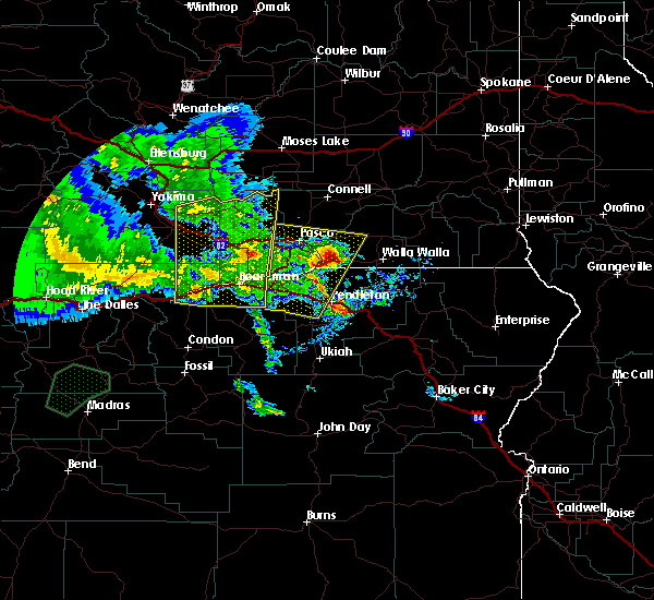
 At 443 pm pdt, an area of severe thunderstorms were located along a line extending from near roosevelt to 11 miles north of paterson, moving north at 45 to 55 mph (radar indicated and spotter verified with several reports of winds in excess of 60 mph and significant blowing dust). Hazards include 70 mph wind gusts and quarter size hail, as well as blowing dust leading to near zero visibilities. Hail damage to vehicles is expected. expect considerable tree damage. Wind damage is also likely to mobile homes, roofs, and outbuildings. At 443 pm pdt, an area of severe thunderstorms were located along a line extending from near roosevelt to 11 miles north of paterson, moving north at 45 to 55 mph (radar indicated and spotter verified with several reports of winds in excess of 60 mph and significant blowing dust). Hazards include 70 mph wind gusts and quarter size hail, as well as blowing dust leading to near zero visibilities. Hail damage to vehicles is expected. expect considerable tree damage. Wind damage is also likely to mobile homes, roofs, and outbuildings.
|
| 5/30/2020 4:45 PM PDT |
 At 443 pm pdt, an area of severe thunderstorms were located along a line extending from near roosevelt to 11 miles north of paterson, moving north at 45 to 55 mph (radar indicated and spotter verified with several reports of winds in excess of 60 mph and significant blowing dust). Hazards include 70 mph wind gusts and quarter size hail, as well as blowing dust leading to near zero visibilities. Hail damage to vehicles is expected. expect considerable tree damage. Wind damage is also likely to mobile homes, roofs, and outbuildings. At 443 pm pdt, an area of severe thunderstorms were located along a line extending from near roosevelt to 11 miles north of paterson, moving north at 45 to 55 mph (radar indicated and spotter verified with several reports of winds in excess of 60 mph and significant blowing dust). Hazards include 70 mph wind gusts and quarter size hail, as well as blowing dust leading to near zero visibilities. Hail damage to vehicles is expected. expect considerable tree damage. Wind damage is also likely to mobile homes, roofs, and outbuildings.
|
| 5/30/2020 4:25 PM PDT |
Mesonet station xaln arlington port - higher gus in gilliam county OR, 0.9 miles E of Arlington, OR
|
| 5/30/2020 4:22 PM PDT |
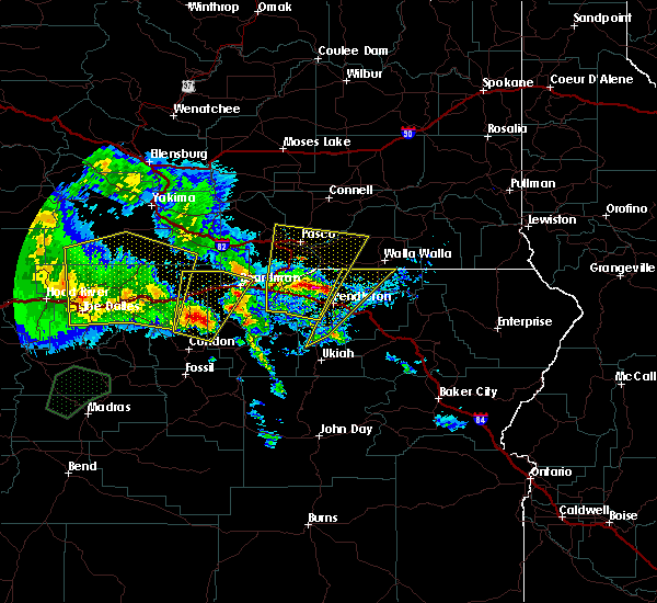
 At 421 pm pdt, a severe thunderstorm was located near cecil, or 13 miles southeast of arlington, moving north at 55 mph (radar indicated). Hazards include 60 mph wind gusts and quarter size hail. Hail damage to vehicles is expected. expect wind damage to roofs, siding, and trees. Locations impacted include, boardman, arlington, alderdale, olex, mikkalo, cecil and roosevelt. At 421 pm pdt, a severe thunderstorm was located near cecil, or 13 miles southeast of arlington, moving north at 55 mph (radar indicated). Hazards include 60 mph wind gusts and quarter size hail. Hail damage to vehicles is expected. expect wind damage to roofs, siding, and trees. Locations impacted include, boardman, arlington, alderdale, olex, mikkalo, cecil and roosevelt.
|
| 5/30/2020 4:22 PM PDT |
 At 421 pm pdt, a severe thunderstorm was located near cecil, or 13 miles southeast of arlington, moving north at 55 mph (radar indicated). Hazards include 60 mph wind gusts and quarter size hail. Hail damage to vehicles is expected. expect wind damage to roofs, siding, and trees. Locations impacted include, boardman, arlington, alderdale, olex, mikkalo, cecil and roosevelt. At 421 pm pdt, a severe thunderstorm was located near cecil, or 13 miles southeast of arlington, moving north at 55 mph (radar indicated). Hazards include 60 mph wind gusts and quarter size hail. Hail damage to vehicles is expected. expect wind damage to roofs, siding, and trees. Locations impacted include, boardman, arlington, alderdale, olex, mikkalo, cecil and roosevelt.
|
| 5/30/2020 4:10 PM PDT |
Mesonet station xaln arlington por in gilliam county OR, 0.9 miles E of Arlington, OR
|
| 5/30/2020 3:55 PM PDT |
 At 355 pm pdt, a severe thunderstorm was located over condon, moving north at 55 mph (radar indicated). Hazards include 70 mph wind gusts and half dollar size hail. Hail damage to vehicles is expected. expect considerable tree damage. Wind damage is also likely to mobile homes, roofs, and outbuildings. At 355 pm pdt, a severe thunderstorm was located over condon, moving north at 55 mph (radar indicated). Hazards include 70 mph wind gusts and half dollar size hail. Hail damage to vehicles is expected. expect considerable tree damage. Wind damage is also likely to mobile homes, roofs, and outbuildings.
|
| 5/30/2020 3:55 PM PDT |
 At 355 pm pdt, a severe thunderstorm was located over condon, moving north at 55 mph (radar indicated). Hazards include 70 mph wind gusts and half dollar size hail. Hail damage to vehicles is expected. expect considerable tree damage. Wind damage is also likely to mobile homes, roofs, and outbuildings. At 355 pm pdt, a severe thunderstorm was located over condon, moving north at 55 mph (radar indicated). Hazards include 70 mph wind gusts and half dollar size hail. Hail damage to vehicles is expected. expect considerable tree damage. Wind damage is also likely to mobile homes, roofs, and outbuildings.
|
| 11/17/2015 5:10 PM PST |
Storm damage reported in gilliam county OR, 11.7 miles N of Arlington, OR
|
 At 443 pm pdt, an area of severe thunderstorms were located along a line extending from near roosevelt to 11 miles north of paterson, moving north at 45 to 55 mph (radar indicated and spotter verified with several reports of winds in excess of 60 mph and significant blowing dust). Hazards include 70 mph wind gusts and quarter size hail, as well as blowing dust leading to near zero visibilities. Hail damage to vehicles is expected. expect considerable tree damage. Wind damage is also likely to mobile homes, roofs, and outbuildings.
 At 443 pm pdt, an area of severe thunderstorms were located along a line extending from near roosevelt to 11 miles north of paterson, moving north at 45 to 55 mph (radar indicated and spotter verified with several reports of winds in excess of 60 mph and significant blowing dust). Hazards include 70 mph wind gusts and quarter size hail, as well as blowing dust leading to near zero visibilities. Hail damage to vehicles is expected. expect considerable tree damage. Wind damage is also likely to mobile homes, roofs, and outbuildings.
 At 421 pm pdt, a severe thunderstorm was located near cecil, or 13 miles southeast of arlington, moving north at 55 mph (radar indicated). Hazards include 60 mph wind gusts and quarter size hail. Hail damage to vehicles is expected. expect wind damage to roofs, siding, and trees. Locations impacted include, boardman, arlington, alderdale, olex, mikkalo, cecil and roosevelt.
 At 421 pm pdt, a severe thunderstorm was located near cecil, or 13 miles southeast of arlington, moving north at 55 mph (radar indicated). Hazards include 60 mph wind gusts and quarter size hail. Hail damage to vehicles is expected. expect wind damage to roofs, siding, and trees. Locations impacted include, boardman, arlington, alderdale, olex, mikkalo, cecil and roosevelt.
 At 355 pm pdt, a severe thunderstorm was located over condon, moving north at 55 mph (radar indicated). Hazards include 70 mph wind gusts and half dollar size hail. Hail damage to vehicles is expected. expect considerable tree damage. Wind damage is also likely to mobile homes, roofs, and outbuildings.
 At 355 pm pdt, a severe thunderstorm was located over condon, moving north at 55 mph (radar indicated). Hazards include 70 mph wind gusts and half dollar size hail. Hail damage to vehicles is expected. expect considerable tree damage. Wind damage is also likely to mobile homes, roofs, and outbuildings.


Connect with Interactive Hail Maps