

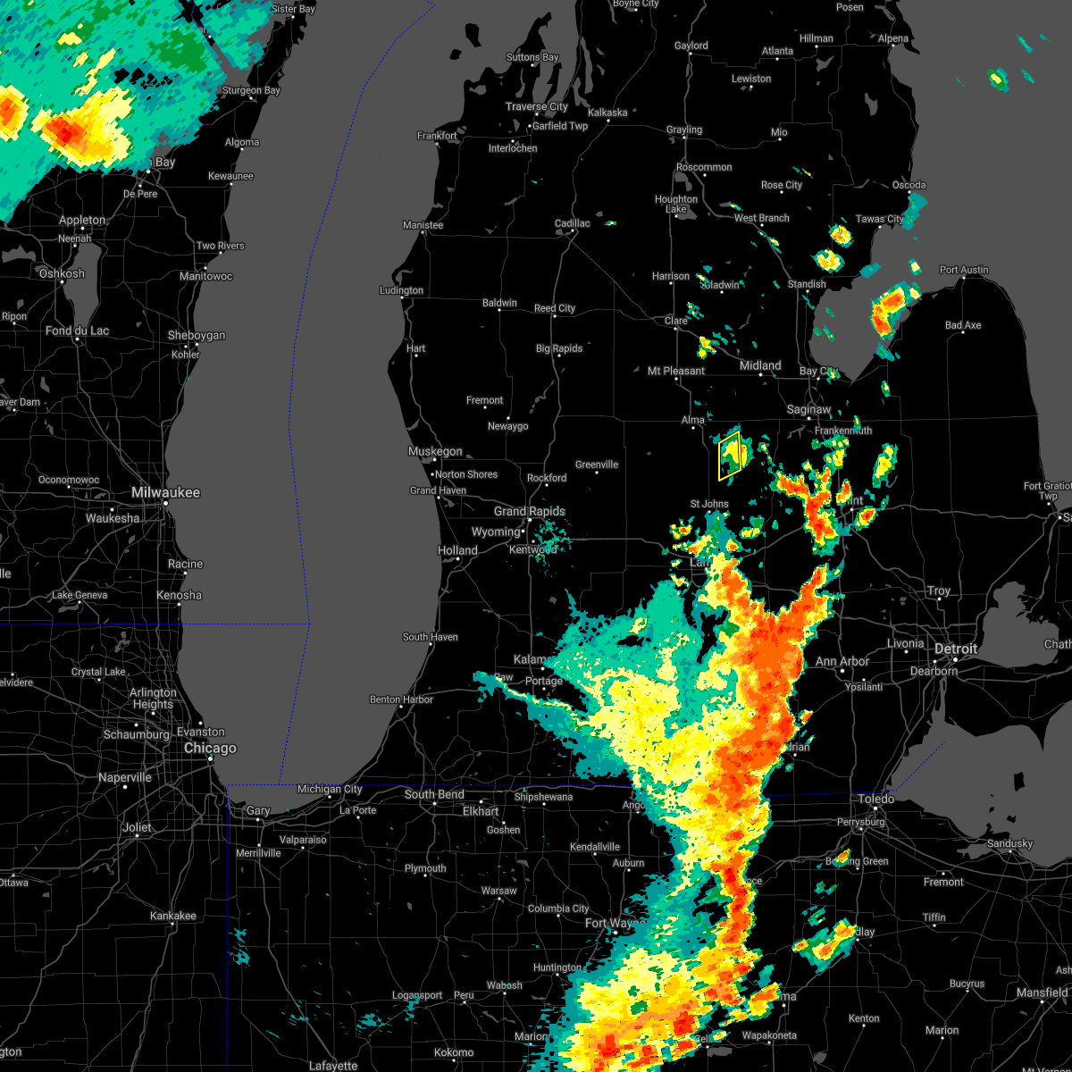
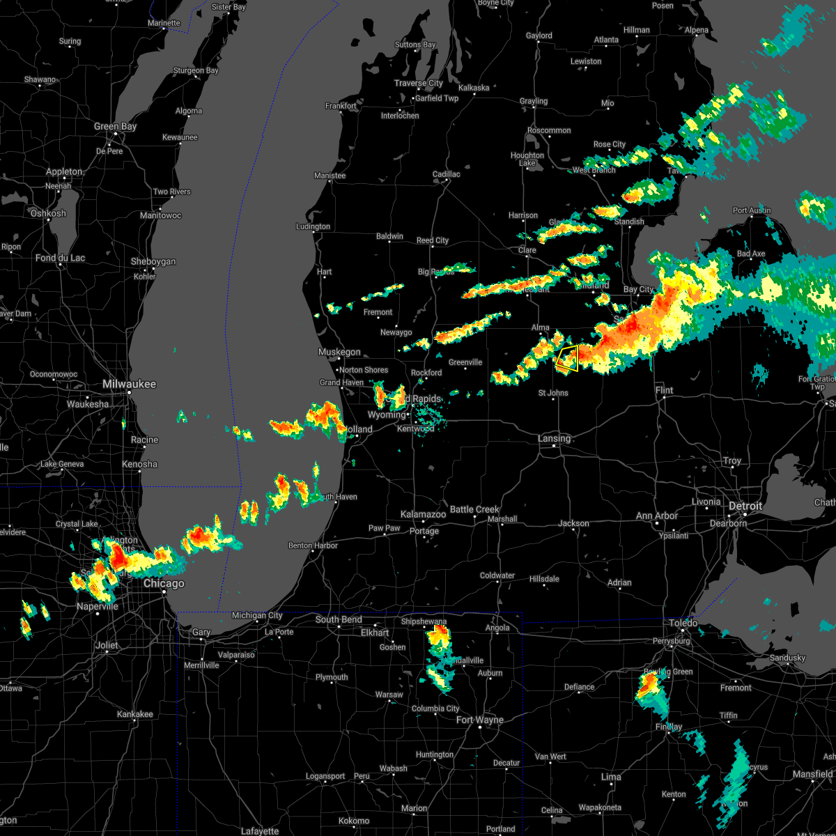
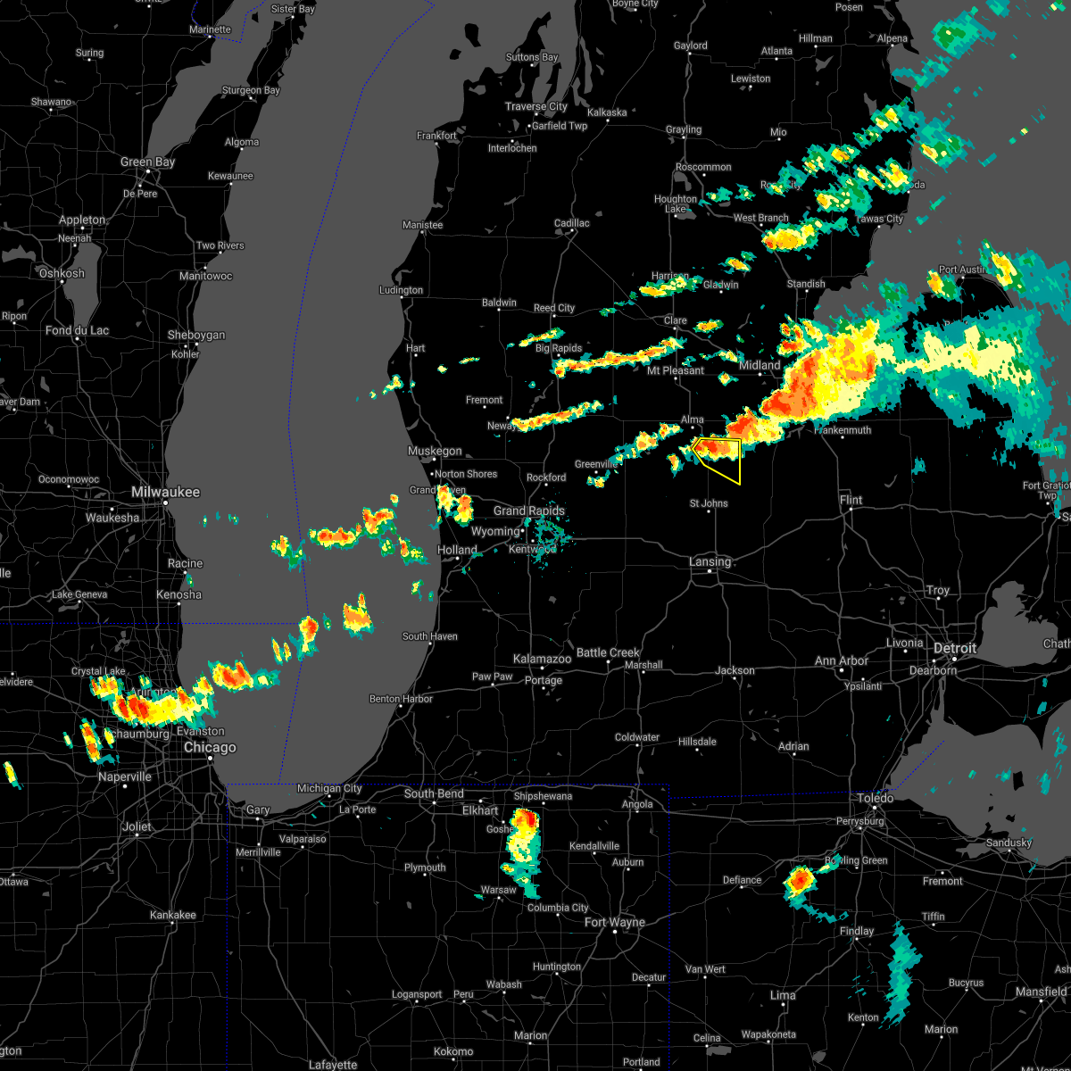
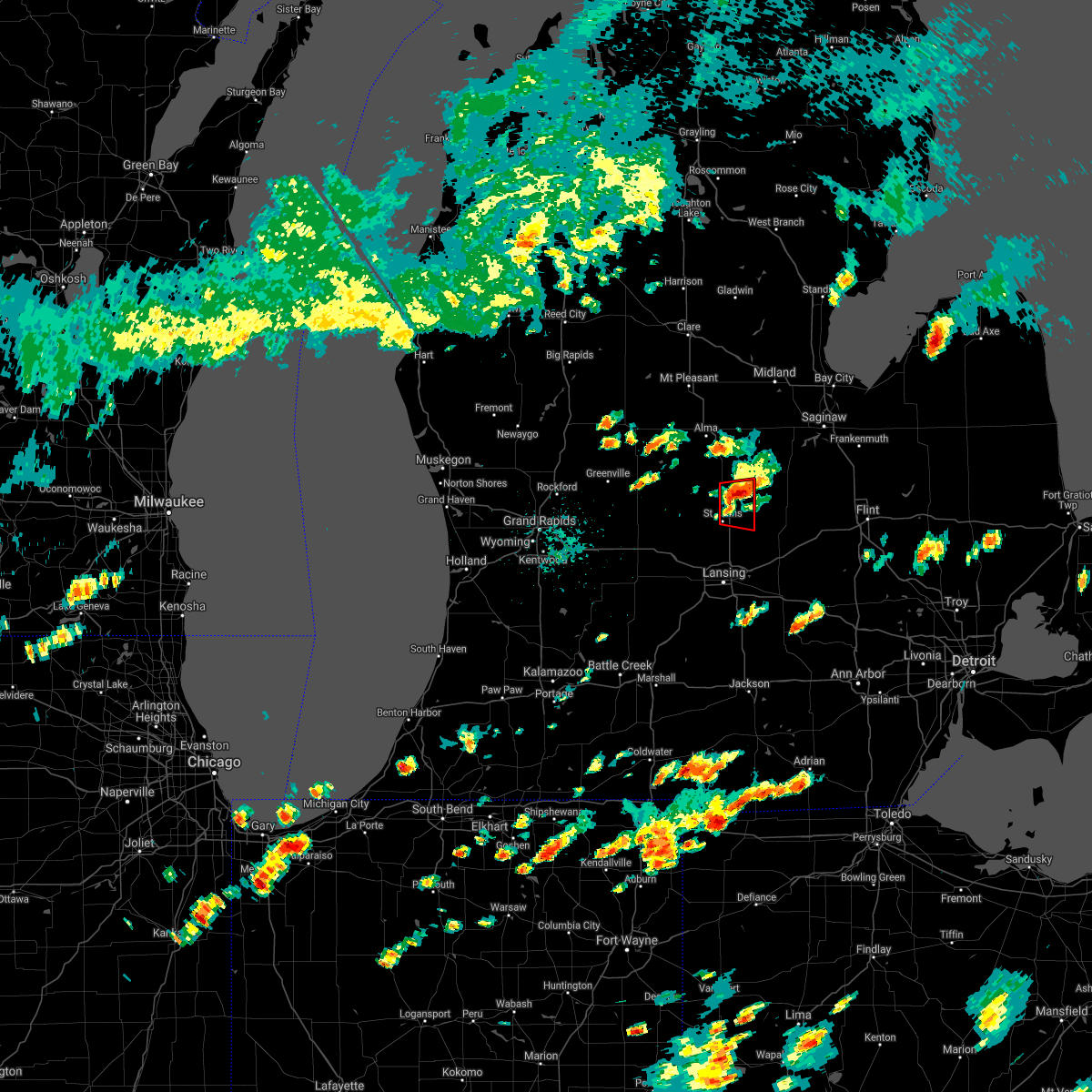
Hail Map for Ashley, MI
The Ashley, MI area has had 1 report of on-the-ground hail by trained spotters, and has been under severe weather warnings 6 times during the past 12 months. Doppler radar has detected hail at or near Ashley, MI on 20 occasions, including 2 occasions during the past year.
| Name: | Ashley, MI |
| Where Located: | 41.8 miles WNW of Flint, MI |
| Map: | Google Map for Ashley, MI |
| Population: | 563 |
| Housing Units: | 221 |
| More Info: | Search Google for Ashley, MI |
2
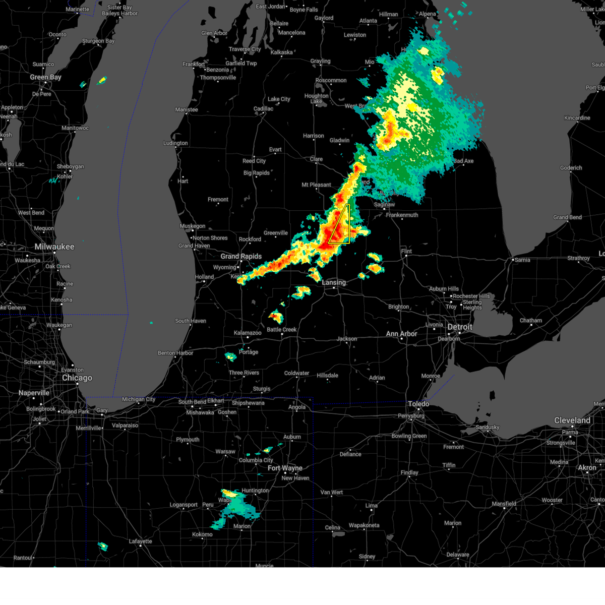
The Top Recent Hail Date for Ashley, MI is Thursday, July 20, 2023 (6th out of 20)

Hail and Wind Damage Spotted near Ashley, MI
| Date / Time | Report Details |
|---|---|
| 7/20/2023 2:11 PM EDT |
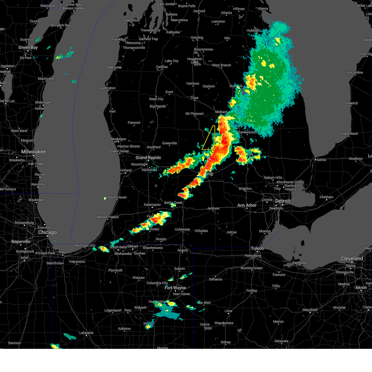 The severe thunderstorm warning for eastern gratiot county will expire at 215 pm edt, the storms which prompted the warning were moving out of the warned area. therefore, the warning will be allowed to expire. a severe thunderstorm watch remains in effect until 800 pm edt for central michigan. The severe thunderstorm warning for eastern gratiot county will expire at 215 pm edt, the storms which prompted the warning were moving out of the warned area. therefore, the warning will be allowed to expire. a severe thunderstorm watch remains in effect until 800 pm edt for central michigan.
|
| 7/20/2023 1:55 PM EDT | Several trees down in southeast gratiot county. time estimated from rada in gratiot county MI, 0.4 miles SSE of Ashley, MI |
| 7/20/2023 1:52 PM EDT |
 At 152 pm edt, severe thunderstorms were located along a line extending from near merrill to 7 miles west of elsie, moving east at 40 mph (radar indicated). Hazards include 60 mph wind gusts and quarter size hail. Hail damage to vehicles is expected. expect wind damage to roofs, siding, and trees. Locations impacted include, wheeler, north star, ashley, bannister,. At 152 pm edt, severe thunderstorms were located along a line extending from near merrill to 7 miles west of elsie, moving east at 40 mph (radar indicated). Hazards include 60 mph wind gusts and quarter size hail. Hail damage to vehicles is expected. expect wind damage to roofs, siding, and trees. Locations impacted include, wheeler, north star, ashley, bannister,.
|
| 7/20/2023 1:08 PM EDT |
 At 108 pm edt, severe thunderstorms were located along a line extending from 7 miles east of edmore to 8 miles south of stanton, moving east at 45 mph (radar indicated). Hazards include 60 mph wind gusts and quarter size hail. Hail damage to vehicles is expected. Expect wind damage to roofs, siding, and trees. At 108 pm edt, severe thunderstorms were located along a line extending from 7 miles east of edmore to 8 miles south of stanton, moving east at 45 mph (radar indicated). Hazards include 60 mph wind gusts and quarter size hail. Hail damage to vehicles is expected. Expect wind damage to roofs, siding, and trees.
|
| 6/25/2023 6:27 PM EDT |
 The severe thunderstorm warning for gratiot and isabella counties will expire at 630 pm edt, the storms which prompted the warning have weakened and moved out of the warned area. therefore, the warning will be allowed to expire. a severe thunderstorm watch remains in effect until 700 pm edt for central michigan. The severe thunderstorm warning for gratiot and isabella counties will expire at 630 pm edt, the storms which prompted the warning have weakened and moved out of the warned area. therefore, the warning will be allowed to expire. a severe thunderstorm watch remains in effect until 700 pm edt for central michigan.
|
| 6/25/2023 6:04 PM EDT |
 At 604 pm edt, severe thunderstorms were located along a line extending from farwell to ithaca, moving northeast at 30 mph (radar indicated). Hazards include 60 mph wind gusts and penny size hail. Expect damage to roofs, siding, and trees. locations impacted include, mount pleasant, alma, clare, ithaca, st. louis, shepherd, breckenridge, rosebush, wheeler, north star, ashley, perrinton, brinton, loomis, gratiot community ai, bannister, forest hill, pompeii, delwin, beal city, hail threat, radar indicated max hail size, 0. 75 in wind threat, radar indicated max wind gust, 60 mph. At 604 pm edt, severe thunderstorms were located along a line extending from farwell to ithaca, moving northeast at 30 mph (radar indicated). Hazards include 60 mph wind gusts and penny size hail. Expect damage to roofs, siding, and trees. locations impacted include, mount pleasant, alma, clare, ithaca, st. louis, shepherd, breckenridge, rosebush, wheeler, north star, ashley, perrinton, brinton, loomis, gratiot community ai, bannister, forest hill, pompeii, delwin, beal city, hail threat, radar indicated max hail size, 0. 75 in wind threat, radar indicated max wind gust, 60 mph.
|
| 6/25/2023 5:32 PM EDT |
 At 531 pm edt, severe thunderstorms were located along a line extending from 6 miles northeast of mecosta to near carson city, moving northeast at 30 mph (radar indicated). Hazards include 60 mph wind gusts and penny size hail. expect damage to roofs, siding, and trees At 531 pm edt, severe thunderstorms were located along a line extending from 6 miles northeast of mecosta to near carson city, moving northeast at 30 mph (radar indicated). Hazards include 60 mph wind gusts and penny size hail. expect damage to roofs, siding, and trees
|
| 4/5/2023 11:07 AM EDT |
 The severe thunderstorm warning for gratiot county will expire at 1115 am edt, the storms which prompted the warning have moved out of the warned area. therefore, the warning will be allowed to expire. a tornado watch remains in effect until 400 pm edt for central michigan. The severe thunderstorm warning for gratiot county will expire at 1115 am edt, the storms which prompted the warning have moved out of the warned area. therefore, the warning will be allowed to expire. a tornado watch remains in effect until 400 pm edt for central michigan.
|
| 4/5/2023 10:34 AM EDT |
 At 1033 am edt, severe thunderstorms were located along a line extending from near edmore to near ionia, moving east at 75 mph (radar indicated). Hazards include 60 mph wind gusts. expect damage to roofs, siding, and trees At 1033 am edt, severe thunderstorms were located along a line extending from near edmore to near ionia, moving east at 75 mph (radar indicated). Hazards include 60 mph wind gusts. expect damage to roofs, siding, and trees
|
| 9/21/2022 9:57 AM EDT |
 The severe thunderstorm warning for gratiot county will expire at 1000 am edt, the storms which prompted the warning have moved out of the warned area. therefore, the warning will be allowed to expire. The severe thunderstorm warning for gratiot county will expire at 1000 am edt, the storms which prompted the warning have moved out of the warned area. therefore, the warning will be allowed to expire.
|
| 9/21/2022 9:17 AM EDT |
 At 917 am edt, severe thunderstorms were located along a line extending from near breckenridge to 5 miles southwest of alma, moving east at 40 mph (radar indicated). Hazards include 60 mph wind gusts and quarter size hail. Hail damage to vehicles is expected. Expect wind damage to roofs, siding, and trees. At 917 am edt, severe thunderstorms were located along a line extending from near breckenridge to 5 miles southwest of alma, moving east at 40 mph (radar indicated). Hazards include 60 mph wind gusts and quarter size hail. Hail damage to vehicles is expected. Expect wind damage to roofs, siding, and trees.
|
| 8/29/2022 5:12 PM EDT |
 The severe thunderstorm warning for northern ingham, eastern gratiot, clinton and northeastern eaton counties will expire at 515 pm edt, the storms which prompted the warning will soon exit the warned area. therefore, the warning will be allowed to expire. a severe thunderstorm watch remains in effect until 800 pm edt for south central and central michigan. The severe thunderstorm warning for northern ingham, eastern gratiot, clinton and northeastern eaton counties will expire at 515 pm edt, the storms which prompted the warning will soon exit the warned area. therefore, the warning will be allowed to expire. a severe thunderstorm watch remains in effect until 800 pm edt for south central and central michigan.
|
| 8/29/2022 5:01 PM EDT |
 At 459 pm edt, severe thunderstorms were located along a line extending from 5 miles north of marion springs to near henderson to near lansing, moving east at 40 mph (radar indicated. these storms have a history of producing damaging winds and power outages). Hazards include 60 mph wind gusts and quarter size hail. Hail damage to vehicles is expected. expect wind damage to roofs, siding, and trees. locations impacted include, lansing, mason, st. johns, ithaca, east lansing, grand ledge, st. louis, williamston, potterville, breckenridge, elsie, edgemont park, dewitt, eureka, wheeler, ovid, webberville, dimondale, north star, hail threat, radar indicated max hail size, 1. 00 in wind threat, observed max wind gust, 60 mph. At 459 pm edt, severe thunderstorms were located along a line extending from 5 miles north of marion springs to near henderson to near lansing, moving east at 40 mph (radar indicated. these storms have a history of producing damaging winds and power outages). Hazards include 60 mph wind gusts and quarter size hail. Hail damage to vehicles is expected. expect wind damage to roofs, siding, and trees. locations impacted include, lansing, mason, st. johns, ithaca, east lansing, grand ledge, st. louis, williamston, potterville, breckenridge, elsie, edgemont park, dewitt, eureka, wheeler, ovid, webberville, dimondale, north star, hail threat, radar indicated max hail size, 1. 00 in wind threat, observed max wind gust, 60 mph.
|
| 8/29/2022 4:31 PM EDT |
 At 430 pm edt, severe thunderstorms were located along a line extending from near ithaca to near st. johns to 6 miles northwest of charlotte, moving east at 55 mph (trained weather spotters). Hazards include 60 mph wind gusts and quarter size hail. Hail damage to vehicles is expected. expect wind damage to roofs, siding, and trees. locations impacted include, lansing, alma, charlotte, mason, st. johns, ithaca, east lansing, grand ledge, st. louis, williamston, potterville, breckenridge, elsie, edgemont park, dewitt, capital region inter, eureka, wheeler, sumner, ovid, hail threat, radar indicated max hail size, 1. 00 in wind threat, radar indicated max wind gust, 60 mph. At 430 pm edt, severe thunderstorms were located along a line extending from near ithaca to near st. johns to 6 miles northwest of charlotte, moving east at 55 mph (trained weather spotters). Hazards include 60 mph wind gusts and quarter size hail. Hail damage to vehicles is expected. expect wind damage to roofs, siding, and trees. locations impacted include, lansing, alma, charlotte, mason, st. johns, ithaca, east lansing, grand ledge, st. louis, williamston, potterville, breckenridge, elsie, edgemont park, dewitt, capital region inter, eureka, wheeler, sumner, ovid, hail threat, radar indicated max hail size, 1. 00 in wind threat, radar indicated max wind gust, 60 mph.
|
| 8/29/2022 3:47 PM EDT |
 At 345 pm edt, a line of severe thunderstorms was located along a line from grand rapids to near stanton, moving east at 45 mph. these storms have a history of producing wind damage and power outages. seek shelter inside a sturdy building (trained weather spotters). Hazards include 60 mph wind gusts and quarter size hail. Hail damage to vehicles is expected. Expect wind damage to roofs, siding, and trees. At 345 pm edt, a line of severe thunderstorms was located along a line from grand rapids to near stanton, moving east at 45 mph. these storms have a history of producing wind damage and power outages. seek shelter inside a sturdy building (trained weather spotters). Hazards include 60 mph wind gusts and quarter size hail. Hail damage to vehicles is expected. Expect wind damage to roofs, siding, and trees.
|
| 8/3/2022 3:04 PM EDT |
 At 303 pm edt, severe thunderstorms were located along a line extending from 10 miles north of st. johns to near portland, moving east at 35 mph (radar indicated). Hazards include 60 mph wind gusts and quarter size hail. Hail damage to vehicles is expected. Expect wind damage to roofs, siding, and trees. At 303 pm edt, severe thunderstorms were located along a line extending from 10 miles north of st. johns to near portland, moving east at 35 mph (radar indicated). Hazards include 60 mph wind gusts and quarter size hail. Hail damage to vehicles is expected. Expect wind damage to roofs, siding, and trees.
|
| 7/23/2022 11:43 PM EDT |
 The severe thunderstorm warning for ingham, gratiot and clinton counties will expire at 1145 pm edt, the storms which prompted the warning have moved out of the area. therefore, the warning will be allowed to expire. a severe thunderstorm watch remains in effect until midnight edt for south central and central michigan. The severe thunderstorm warning for ingham, gratiot and clinton counties will expire at 1145 pm edt, the storms which prompted the warning have moved out of the area. therefore, the warning will be allowed to expire. a severe thunderstorm watch remains in effect until midnight edt for south central and central michigan.
|
| 7/23/2022 11:27 PM EDT |
 At 1126 pm edt, severe thunderstorms were located along a line extending from near ithaca to near elsie to 5 miles west of mason, moving east at 45 mph (radar indicated. at 1115 pm, 60 mph was reported at the capital city airport in lansing). Hazards include 60 mph wind gusts and quarter size hail. Hail damage to vehicles is expected. expect wind damage to roofs, siding, and trees. locations impacted include, lansing, mason, st. johns, ithaca, east lansing, grand ledge, williamston, elsie, edgemont park, dewitt, eureka, sumner, ovid, webberville, fowler, north star, westphalia, maple rapids, dansville, ashley, hail threat, radar indicated max hail size, 1. 00 in wind threat, observed max wind gust, 60 mph. At 1126 pm edt, severe thunderstorms were located along a line extending from near ithaca to near elsie to 5 miles west of mason, moving east at 45 mph (radar indicated. at 1115 pm, 60 mph was reported at the capital city airport in lansing). Hazards include 60 mph wind gusts and quarter size hail. Hail damage to vehicles is expected. expect wind damage to roofs, siding, and trees. locations impacted include, lansing, mason, st. johns, ithaca, east lansing, grand ledge, williamston, elsie, edgemont park, dewitt, eureka, sumner, ovid, webberville, fowler, north star, westphalia, maple rapids, dansville, ashley, hail threat, radar indicated max hail size, 1. 00 in wind threat, observed max wind gust, 60 mph.
|
| 7/23/2022 10:58 PM EDT |
 At 1058 pm edt, severe thunderstorms were located along a line extending from 6 miles northwest of carson city to 6 miles northwest of st. johns to 5 miles west of charlotte, moving east at 55 mph (radar indicated). Hazards include 60 mph wind gusts and quarter size hail. Hail damage to vehicles is expected. Expect wind damage to roofs, siding, and trees. At 1058 pm edt, severe thunderstorms were located along a line extending from 6 miles northwest of carson city to 6 miles northwest of st. johns to 5 miles west of charlotte, moving east at 55 mph (radar indicated). Hazards include 60 mph wind gusts and quarter size hail. Hail damage to vehicles is expected. Expect wind damage to roofs, siding, and trees.
|
| 9/12/2021 7:16 PM EDT |
 At 715 pm edt, a severe thunderstorm was located over edmore, or 6 miles north of stanton, moving east at 50 mph (radar indicated). Hazards include quarter size hail. Damage to vehicles is expected. this severe thunderstorm will be near, alma and st. louis around 740 pm edt. ithaca around 745 pm edt. breckenridge around 750 pm edt. other locations impacted by this severe thunderstorm include mcbride, westville, elm hall, cedar lake, north star, vestaburg, forest hill, sumner, riverdale and ashley. hail threat, radar indicated max hail size, 1. 00 in wind threat, radar indicated max wind gust, <50 mph. At 715 pm edt, a severe thunderstorm was located over edmore, or 6 miles north of stanton, moving east at 50 mph (radar indicated). Hazards include quarter size hail. Damage to vehicles is expected. this severe thunderstorm will be near, alma and st. louis around 740 pm edt. ithaca around 745 pm edt. breckenridge around 750 pm edt. other locations impacted by this severe thunderstorm include mcbride, westville, elm hall, cedar lake, north star, vestaburg, forest hill, sumner, riverdale and ashley. hail threat, radar indicated max hail size, 1. 00 in wind threat, radar indicated max wind gust, <50 mph.
|
| 9/7/2021 4:08 PM EDT |
 At 407 pm edt, severe thunderstorms were located along a line extending from near merrill to near carson city, moving east at 65 mph (trained weather spotters). Hazards include 60 mph wind gusts and quarter size hail. Hail damage to vehicles is expected. expect wind damage to roofs, siding, and trees. locations impacted include, alma, ithaca, st. louis, breckenridge, wheeler, sumner, north star, ashley, perrinton, pompeii, middleton, bannister, hail threat, radar indicated max hail size, 1. 00 in wind threat, radar indicated max wind gust, 60 mph. At 407 pm edt, severe thunderstorms were located along a line extending from near merrill to near carson city, moving east at 65 mph (trained weather spotters). Hazards include 60 mph wind gusts and quarter size hail. Hail damage to vehicles is expected. expect wind damage to roofs, siding, and trees. locations impacted include, alma, ithaca, st. louis, breckenridge, wheeler, sumner, north star, ashley, perrinton, pompeii, middleton, bannister, hail threat, radar indicated max hail size, 1. 00 in wind threat, radar indicated max wind gust, 60 mph.
|
| 9/7/2021 3:40 PM EDT |
 At 339 pm edt, severe thunderstorms were located along a line extending from 5 miles northwest of merrill to 6 miles north of ionia, moving east at 40 mph (trained weather spotters. at 336 pm quarter sized hail was reported just east of alma). Hazards include 60 mph wind gusts and quarter size hail. Hail damage to vehicles is expected. expect wind damage to roofs, siding, and trees. locations impacted include, ionia, alma, st. johns, belding, portland, ithaca, grand ledge, st. louis, lake odessa, breckenridge, saranac, elsie, dewitt, eureka, wheeler, orleans, sumner, ovid, fowler, sebewa, hail threat, observed max hail size, 1. 00 in wind threat, radar indicated max wind gust, 60 mph. At 339 pm edt, severe thunderstorms were located along a line extending from 5 miles northwest of merrill to 6 miles north of ionia, moving east at 40 mph (trained weather spotters. at 336 pm quarter sized hail was reported just east of alma). Hazards include 60 mph wind gusts and quarter size hail. Hail damage to vehicles is expected. expect wind damage to roofs, siding, and trees. locations impacted include, ionia, alma, st. johns, belding, portland, ithaca, grand ledge, st. louis, lake odessa, breckenridge, saranac, elsie, dewitt, eureka, wheeler, orleans, sumner, ovid, fowler, sebewa, hail threat, observed max hail size, 1. 00 in wind threat, radar indicated max wind gust, 60 mph.
|
| 9/7/2021 3:26 PM EDT |
 At 326 pm edt, a severe thunderstorm was located 6 miles southeast of carson city, or 12 miles southwest of ithaca, moving east at 35 mph (radar indicated). Hazards include 60 mph wind gusts and quarter size hail. Hail damage to vehicles is expected. Expect wind damage to roofs, siding, and trees. At 326 pm edt, a severe thunderstorm was located 6 miles southeast of carson city, or 12 miles southwest of ithaca, moving east at 35 mph (radar indicated). Hazards include 60 mph wind gusts and quarter size hail. Hail damage to vehicles is expected. Expect wind damage to roofs, siding, and trees.
|
| 8/28/2021 8:07 PM EDT |
 At 807 pm edt, severe thunderstorms were located along a line extending from 5 miles west of freeland to 5 miles northwest of st. charles, moving northeast at 35 mph (radar indicated). Hazards include 60 mph wind gusts and quarter size hail. Hail damage to vehicles is expected. expect wind damage to roofs, siding, and trees. locations impacted include, ashley, bannister, hail threat, radar indicated max hail size, 1. 00 in wind threat, radar indicated max wind gust, 60 mph. At 807 pm edt, severe thunderstorms were located along a line extending from 5 miles west of freeland to 5 miles northwest of st. charles, moving northeast at 35 mph (radar indicated). Hazards include 60 mph wind gusts and quarter size hail. Hail damage to vehicles is expected. expect wind damage to roofs, siding, and trees. locations impacted include, ashley, bannister, hail threat, radar indicated max hail size, 1. 00 in wind threat, radar indicated max wind gust, 60 mph.
|
| 8/28/2021 7:33 PM EDT |
 At 732 pm edt, severe thunderstorms were located along a line extending from 5 miles south of breckenridge to 6 miles northwest of elsie, moving northeast at 35 mph (radar indicated). Hazards include 60 mph wind gusts and quarter size hail. Hail damage to vehicles is expected. Expect wind damage to roofs, siding, and trees. At 732 pm edt, severe thunderstorms were located along a line extending from 5 miles south of breckenridge to 6 miles northwest of elsie, moving northeast at 35 mph (radar indicated). Hazards include 60 mph wind gusts and quarter size hail. Hail damage to vehicles is expected. Expect wind damage to roofs, siding, and trees.
|
| 8/24/2021 6:50 PM EDT |
 At 650 pm edt, a severe thunderstorm was located 8 miles west of st. johns, moving east at 30 mph (radar indicated). Hazards include 60 mph wind gusts. Expect damage to roofs, siding, and trees. locations impacted include, ionia, st. johns, ithaca, breckenridge, saranac, elsie, eureka, wheeler, ovid, fowler, north star, westphalia, lyons, maple rapids, muir, ashley, pewamo, perrinton, hubbardston, bannister, hail threat, radar indicated max hail size, <. 75 in wind threat, radar indicated max wind gust, 60 mph. At 650 pm edt, a severe thunderstorm was located 8 miles west of st. johns, moving east at 30 mph (radar indicated). Hazards include 60 mph wind gusts. Expect damage to roofs, siding, and trees. locations impacted include, ionia, st. johns, ithaca, breckenridge, saranac, elsie, eureka, wheeler, ovid, fowler, north star, westphalia, lyons, maple rapids, muir, ashley, pewamo, perrinton, hubbardston, bannister, hail threat, radar indicated max hail size, <. 75 in wind threat, radar indicated max wind gust, 60 mph.
|
| 8/24/2021 6:06 PM EDT |
 At 606 pm edt, a severe thunderstorm was located near carson city, or 10 miles southeast of stanton, moving east at 20 mph (radar indicated). Hazards include 60 mph wind gusts. expect damage to roofs, siding, and trees At 606 pm edt, a severe thunderstorm was located near carson city, or 10 miles southeast of stanton, moving east at 20 mph (radar indicated). Hazards include 60 mph wind gusts. expect damage to roofs, siding, and trees
|
| 8/11/2021 2:45 PM EDT |
 At 245 pm edt, a severe thunderstorm was located near marion springs, or 10 miles east of ithaca, moving east at 45 mph (radar indicated). Hazards include 60 mph wind gusts. Expect damage to roofs, siding, and trees. locations impacted include, ashley, hail threat, radar indicated max hail size, <. 75 in wind threat, radar indicated max wind gust, 60 mph. At 245 pm edt, a severe thunderstorm was located near marion springs, or 10 miles east of ithaca, moving east at 45 mph (radar indicated). Hazards include 60 mph wind gusts. Expect damage to roofs, siding, and trees. locations impacted include, ashley, hail threat, radar indicated max hail size, <. 75 in wind threat, radar indicated max wind gust, 60 mph.
|
| 8/11/2021 2:30 PM EDT |
 At 229 pm edt, a severe thunderstorm was located 6 miles south of ithaca, moving northeast at 50 mph (radar indicated). Hazards include 60 mph wind gusts. Expect damage to roofs, siding, and trees. this severe thunderstorm will remain over mainly rural areas of southern gratiot and north central clinton counties, including the following locations, pompeii, middleton, north star, ashley, perrinton, eureka, and bannister. hail threat, radar indicated max hail size, <. 75 in wind threat, radar indicated max wind gust, 60 mph. At 229 pm edt, a severe thunderstorm was located 6 miles south of ithaca, moving northeast at 50 mph (radar indicated). Hazards include 60 mph wind gusts. Expect damage to roofs, siding, and trees. this severe thunderstorm will remain over mainly rural areas of southern gratiot and north central clinton counties, including the following locations, pompeii, middleton, north star, ashley, perrinton, eureka, and bannister. hail threat, radar indicated max hail size, <. 75 in wind threat, radar indicated max wind gust, 60 mph.
|
| 8/11/2021 2:11 PM EDT |
 At 211 pm edt, a severe thunderstorm was located near carson city, or 11 miles northeast of ionia, moving east at 40 mph (radar indicated). Hazards include 60 mph wind gusts. Expect damage to roofs, siding, and trees. this severe thunderstorm will be near, carson city around 220 pm edt. other locations in the path of this severe thunderstorm include ithaca. hail threat, radar indicated max hail size, <. 75 in wind threat, radar indicated max wind gust, 60 mph. At 211 pm edt, a severe thunderstorm was located near carson city, or 11 miles northeast of ionia, moving east at 40 mph (radar indicated). Hazards include 60 mph wind gusts. Expect damage to roofs, siding, and trees. this severe thunderstorm will be near, carson city around 220 pm edt. other locations in the path of this severe thunderstorm include ithaca. hail threat, radar indicated max hail size, <. 75 in wind threat, radar indicated max wind gust, 60 mph.
|
| 8/11/2021 12:07 AM EDT |
 The severe thunderstorm warning for jackson, ingham, gratiot, isabella, clare and clinton counties will expire at 1215 am edt, the storms which prompted the warning have moved out of the area. therefore, the warning will be allowed to expire. a severe thunderstorm watch remains in effect until 300 am edt for south central and central michigan. The severe thunderstorm warning for jackson, ingham, gratiot, isabella, clare and clinton counties will expire at 1215 am edt, the storms which prompted the warning have moved out of the area. therefore, the warning will be allowed to expire. a severe thunderstorm watch remains in effect until 300 am edt for south central and central michigan.
|
| 8/10/2021 11:09 PM EDT |
 At 1108 pm edt, severe thunderstorms were located along a line extending from 9 miles south of mitchell state park to near canadian lakes to 6 miles east of greenville to near nashville to 5 miles west of union city, moving east at 55 mph (radar indicated). Hazards include 60 mph wind gusts. expect damage to roofs, siding, and trees At 1108 pm edt, severe thunderstorms were located along a line extending from 9 miles south of mitchell state park to near canadian lakes to 6 miles east of greenville to near nashville to 5 miles west of union city, moving east at 55 mph (radar indicated). Hazards include 60 mph wind gusts. expect damage to roofs, siding, and trees
|
| 7/24/2021 5:09 PM EDT |
 At 509 pm edt, a severe thunderstorm was located near ashley, or 9 miles southeast of ithaca, moving east at 30 mph (radar indicated). Hazards include 60 mph wind gusts. Expect damage to roofs, siding, and trees. Locations impacted include, ashley,. At 509 pm edt, a severe thunderstorm was located near ashley, or 9 miles southeast of ithaca, moving east at 30 mph (radar indicated). Hazards include 60 mph wind gusts. Expect damage to roofs, siding, and trees. Locations impacted include, ashley,.
|
| 7/24/2021 4:53 PM EDT |
 At 453 pm edt, a severe thunderstorm was located near ithaca, moving east at 35 mph (radar indicated). Hazards include 60 mph wind gusts. Expect damage to roofs, siding, and trees. Locations impacted include, ithaca, north star, ashley,. At 453 pm edt, a severe thunderstorm was located near ithaca, moving east at 35 mph (radar indicated). Hazards include 60 mph wind gusts. Expect damage to roofs, siding, and trees. Locations impacted include, ithaca, north star, ashley,.
|
| 7/24/2021 4:38 PM EDT |
 At 438 pm edt, a severe thunderstorm was located 7 miles west of ithaca, moving east at 35 mph (radar indicated). Hazards include 60 mph wind gusts. expect damage to roofs, siding, and trees At 438 pm edt, a severe thunderstorm was located 7 miles west of ithaca, moving east at 35 mph (radar indicated). Hazards include 60 mph wind gusts. expect damage to roofs, siding, and trees
|
| 7/7/2021 1:57 PM EDT |
 The severe thunderstorm warning for southern gratiot and northern clinton counties will expire at 200 pm edt, the storm which prompted the warning has weakened below severe limits, and has exited the warned area. therefore, the warning will be allowed to expire. a severe thunderstorm watch remains in effect until 900 pm edt for south central michigan. The severe thunderstorm warning for southern gratiot and northern clinton counties will expire at 200 pm edt, the storm which prompted the warning has weakened below severe limits, and has exited the warned area. therefore, the warning will be allowed to expire. a severe thunderstorm watch remains in effect until 900 pm edt for south central michigan.
|
| 7/7/2021 1:18 PM EDT |
 At 118 pm edt, a severe thunderstorm capable of producing a tornado was located near elsie, or 6 miles northeast of st. johns, moving east at 20 mph (radar indicated rotation). Hazards include tornado and golf ball size hail. Flying debris will be dangerous to those caught without shelter. mobile homes will be damaged or destroyed. damage to roofs, windows, and vehicles will occur. tree damage is likely. This dangerous storm will be near, elsie around 130 pm edt. At 118 pm edt, a severe thunderstorm capable of producing a tornado was located near elsie, or 6 miles northeast of st. johns, moving east at 20 mph (radar indicated rotation). Hazards include tornado and golf ball size hail. Flying debris will be dangerous to those caught without shelter. mobile homes will be damaged or destroyed. damage to roofs, windows, and vehicles will occur. tree damage is likely. This dangerous storm will be near, elsie around 130 pm edt.
|
| 7/7/2021 1:07 PM EDT |
 At 107 pm edt, a severe thunderstorm was located 8 miles north of st. johns, moving east at 25 mph (radar indicated). Hazards include 60 mph wind gusts and quarter size hail. Hail damage to vehicles is expected. expect wind damage to roofs, siding, and trees. Locations impacted include, ithaca, elsie, eureka, north star, maple rapids, ashley, perrinton, pompeii, middleton, bannister,. At 107 pm edt, a severe thunderstorm was located 8 miles north of st. johns, moving east at 25 mph (radar indicated). Hazards include 60 mph wind gusts and quarter size hail. Hail damage to vehicles is expected. expect wind damage to roofs, siding, and trees. Locations impacted include, ithaca, elsie, eureka, north star, maple rapids, ashley, perrinton, pompeii, middleton, bannister,.
|
| 7/7/2021 12:54 PM EDT |
 At 1254 pm edt, a severe thunderstorm was located 8 miles east of carson city, or 10 miles southwest of ithaca, moving east at 25 mph (radar indicated). Hazards include 60 mph wind gusts and quarter size hail. Hail damage to vehicles is expected. Expect wind damage to roofs, siding, and trees. At 1254 pm edt, a severe thunderstorm was located 8 miles east of carson city, or 10 miles southwest of ithaca, moving east at 25 mph (radar indicated). Hazards include 60 mph wind gusts and quarter size hail. Hail damage to vehicles is expected. Expect wind damage to roofs, siding, and trees.
|
| 6/12/2021 8:25 PM EDT |
 The severe thunderstorm warning for gratiot and eastern montcalm counties will expire at 830 pm edt, the storm near alma that prompted the warning has weakened below severe limits. a severe thunderstorm south of carson city will move southeast out of gratiot county. therefore, the warning will be allowed to expire. however, small hail, gusty winds and lightning are still possible with any remaining thunderstorms in the area. The severe thunderstorm warning for gratiot and eastern montcalm counties will expire at 830 pm edt, the storm near alma that prompted the warning has weakened below severe limits. a severe thunderstorm south of carson city will move southeast out of gratiot county. therefore, the warning will be allowed to expire. however, small hail, gusty winds and lightning are still possible with any remaining thunderstorms in the area.
|
| 6/12/2021 8:06 PM EDT |
 At 805 pm edt, a severe thunderstorm was located 7 miles east of edmore, or 11 miles west of alma. another severe storm was located just northwest of carson city. both storms were moving southeast at 30 mph (radar indicated). Hazards include 60 mph wind gusts and quarter size hail. Hail damage to vehicles is expected. expect wind damage to roofs, siding, and trees. locations impacted include, alma, ithaca, st. Louis, breckenridge, carson city, wheeler, crystal, sumner, north star, sheridan, ashley, perrinton, elm hall, cedar lake, bannister, vestaburg, forest hill, pompeii, riverdale, middleton,. At 805 pm edt, a severe thunderstorm was located 7 miles east of edmore, or 11 miles west of alma. another severe storm was located just northwest of carson city. both storms were moving southeast at 30 mph (radar indicated). Hazards include 60 mph wind gusts and quarter size hail. Hail damage to vehicles is expected. expect wind damage to roofs, siding, and trees. locations impacted include, alma, ithaca, st. Louis, breckenridge, carson city, wheeler, crystal, sumner, north star, sheridan, ashley, perrinton, elm hall, cedar lake, bannister, vestaburg, forest hill, pompeii, riverdale, middleton,.
|
| 6/12/2021 7:52 PM EDT |
 At 750 pm edt, a severe thunderstorm was located 7 miles northeast of edmore, or 11 miles southwest of mount pleasant. another severe storm was located southeast of stanton. both storms were moving east at 25 mph (radar indicated). Hazards include 60 mph wind gusts and quarter size hail. Hail damage to vehicles is expected. expect wind damage to roofs, siding, and trees. locations impacted include, alma, ithaca, stanton, st. Louis, shepherd, breckenridge, edmore, carson city, wheeler, crystal, sidney, sumner, north star, sheridan, ashley, perrinton, mcbride, westville, elm hall, cedar lake,. At 750 pm edt, a severe thunderstorm was located 7 miles northeast of edmore, or 11 miles southwest of mount pleasant. another severe storm was located southeast of stanton. both storms were moving east at 25 mph (radar indicated). Hazards include 60 mph wind gusts and quarter size hail. Hail damage to vehicles is expected. expect wind damage to roofs, siding, and trees. locations impacted include, alma, ithaca, stanton, st. Louis, shepherd, breckenridge, edmore, carson city, wheeler, crystal, sidney, sumner, north star, sheridan, ashley, perrinton, mcbride, westville, elm hall, cedar lake,.
|
| 6/12/2021 7:43 PM EDT |
 At 743 pm edt, a severe thunderstorm was located 6 miles northeast of edmore, or 11 miles southwest of mount pleasant, moving southeast at 35 mph (radar indicated). Hazards include golf ball size hail and 60 mph wind gusts. People and animals outdoors will be injured. expect hail damage to roofs, siding, windows, and vehicles. Expect wind damage to roofs, siding, and trees. At 743 pm edt, a severe thunderstorm was located 6 miles northeast of edmore, or 11 miles southwest of mount pleasant, moving southeast at 35 mph (radar indicated). Hazards include golf ball size hail and 60 mph wind gusts. People and animals outdoors will be injured. expect hail damage to roofs, siding, windows, and vehicles. Expect wind damage to roofs, siding, and trees.
|
| 6/12/2021 6:24 PM EDT |
 The severe thunderstorm warning for gratiot, northeastern clinton and eastern montcalm counties will expire at 630 pm edt, the storm which prompted the warning has moved out of the area. therefore, the warning will be allowed to expire. to report severe weather, contact your nearest law enforcement agency. they will relay your report to the national weather service grand rapids. The severe thunderstorm warning for gratiot, northeastern clinton and eastern montcalm counties will expire at 630 pm edt, the storm which prompted the warning has moved out of the area. therefore, the warning will be allowed to expire. to report severe weather, contact your nearest law enforcement agency. they will relay your report to the national weather service grand rapids.
|
| 6/12/2021 6:23 PM EDT |
 At 622 pm edt, a severe thunderstorm was located over durand, moving southeast at 35 mph. this is a very dangerous storm (radar indicated). Hazards include baseball size hail and 60 mph wind gusts. People and animals outdoors will be severely injured. expect shattered windows, extensive damage to roofs, siding, and vehicles. locations impacted include, alma, st. johns, ithaca, st. Louis, breckenridge, carson city, elsie, eureka, crystal, sumner, ovid, north star, maple rapids, ashley, perrinton, elm hall, cedar lake, bannister, vestaburg, pompeii,. At 622 pm edt, a severe thunderstorm was located over durand, moving southeast at 35 mph. this is a very dangerous storm (radar indicated). Hazards include baseball size hail and 60 mph wind gusts. People and animals outdoors will be severely injured. expect shattered windows, extensive damage to roofs, siding, and vehicles. locations impacted include, alma, st. johns, ithaca, st. Louis, breckenridge, carson city, elsie, eureka, crystal, sumner, ovid, north star, maple rapids, ashley, perrinton, elm hall, cedar lake, bannister, vestaburg, pompeii,.
|
| 6/12/2021 6:07 PM EDT |
 At 607 pm edt, a severe thunderstorm was located near owosso, moving southeast at 55 mph. this is a very dangerous storm (radar indicated). Hazards include baseball size hail and 60 mph wind gusts. People and animals outdoors will be severely injured. expect shattered windows, extensive damage to roofs, siding, and vehicles. locations impacted include, alma, st. johns, ithaca, st. Louis, breckenridge, carson city, elsie, eureka, crystal, sumner, ovid, north star, maple rapids, ashley, perrinton, elm hall, cedar lake, bannister, vestaburg, pompeii,. At 607 pm edt, a severe thunderstorm was located near owosso, moving southeast at 55 mph. this is a very dangerous storm (radar indicated). Hazards include baseball size hail and 60 mph wind gusts. People and animals outdoors will be severely injured. expect shattered windows, extensive damage to roofs, siding, and vehicles. locations impacted include, alma, st. johns, ithaca, st. Louis, breckenridge, carson city, elsie, eureka, crystal, sumner, ovid, north star, maple rapids, ashley, perrinton, elm hall, cedar lake, bannister, vestaburg, pompeii,.
|
| 6/12/2021 5:51 PM EDT |
 At 551 pm edt, a severe thunderstorm was located near elsie, or 11 miles northeast of st. johns, moving southeast at 15 mph (radar indicated). Hazards include 60 mph wind gusts and quarter size hail. Hail damage to vehicles is expected. expect wind damage to roofs, siding, and trees. locations impacted include, alma, st. johns, ithaca, st. Louis, breckenridge, carson city, elsie, eureka, crystal, sumner, ovid, north star, maple rapids, ashley, perrinton, elm hall, cedar lake, bannister, vestaburg, pompeii,. At 551 pm edt, a severe thunderstorm was located near elsie, or 11 miles northeast of st. johns, moving southeast at 15 mph (radar indicated). Hazards include 60 mph wind gusts and quarter size hail. Hail damage to vehicles is expected. expect wind damage to roofs, siding, and trees. locations impacted include, alma, st. johns, ithaca, st. Louis, breckenridge, carson city, elsie, eureka, crystal, sumner, ovid, north star, maple rapids, ashley, perrinton, elm hall, cedar lake, bannister, vestaburg, pompeii,.
|
| 6/12/2021 5:44 PM EDT |
 At 543 pm edt, a severe thunderstorm was located near elsie, or 11 miles northeast of st. johns, moving southeast at 35 mph (radar indicated). Hazards include 60 mph wind gusts and quarter size hail. Hail damage to vehicles is expected. Expect wind damage to roofs, siding, and trees. At 543 pm edt, a severe thunderstorm was located near elsie, or 11 miles northeast of st. johns, moving southeast at 35 mph (radar indicated). Hazards include 60 mph wind gusts and quarter size hail. Hail damage to vehicles is expected. Expect wind damage to roofs, siding, and trees.
|
| 6/12/2021 5:05 PM EDT |
 At 505 pm edt, a severe thunderstorm was located 6 miles south of breckenridge, or 6 miles east of ithaca, moving southeast at 40 mph (radar indicated). Hazards include 60 mph wind gusts and quarter size hail. Hail damage to vehicles is expected. expect wind damage to roofs, siding, and trees. locations impacted include, alma, ithaca, st. Louis, shepherd, breckenridge, wheeler, north star, ashley, forest hill,. At 505 pm edt, a severe thunderstorm was located 6 miles south of breckenridge, or 6 miles east of ithaca, moving southeast at 40 mph (radar indicated). Hazards include 60 mph wind gusts and quarter size hail. Hail damage to vehicles is expected. expect wind damage to roofs, siding, and trees. locations impacted include, alma, ithaca, st. Louis, shepherd, breckenridge, wheeler, north star, ashley, forest hill,.
|
| 6/12/2021 4:36 PM EDT |
 At 435 pm edt, a severe thunderstorm was located 7 miles southwest of shepherd, or 8 miles south of mount pleasant, moving southeast at 40 mph (radar indicated). Hazards include 60 mph wind gusts and quarter size hail. Hail damage to vehicles is expected. Expect wind damage to roofs, siding, and trees. At 435 pm edt, a severe thunderstorm was located 7 miles southwest of shepherd, or 8 miles south of mount pleasant, moving southeast at 40 mph (radar indicated). Hazards include 60 mph wind gusts and quarter size hail. Hail damage to vehicles is expected. Expect wind damage to roofs, siding, and trees.
|
| 10/23/2020 12:37 PM EDT |
 At 1237 pm edt, severe thunderstorms were located along a line extending from near breckenridge to 9 miles northeast of portland, moving northeast at 45 mph (radar indicated). Hazards include 60 mph wind gusts and penny size hail. expect damage to roofs, siding, and trees At 1237 pm edt, severe thunderstorms were located along a line extending from near breckenridge to 9 miles northeast of portland, moving northeast at 45 mph (radar indicated). Hazards include 60 mph wind gusts and penny size hail. expect damage to roofs, siding, and trees
|
| 8/28/2020 11:19 PM EDT |
 At 1119 pm edt, severe thunderstorms were located along a line extending from 9 miles south of ithaca to 5 miles south of elsie to 5 miles southeast of st. johns, moving east at 50 mph (radar indicated). Hazards include 60 mph wind gusts and penny size hail. Expect damage to roofs, siding, and trees. locations impacted include, st. Johns, elsie, eureka, ovid, ashley, pompeii, bannister,. At 1119 pm edt, severe thunderstorms were located along a line extending from 9 miles south of ithaca to 5 miles south of elsie to 5 miles southeast of st. johns, moving east at 50 mph (radar indicated). Hazards include 60 mph wind gusts and penny size hail. Expect damage to roofs, siding, and trees. locations impacted include, st. Johns, elsie, eureka, ovid, ashley, pompeii, bannister,.
|
| 8/28/2020 10:46 PM EDT |
 At 1046 pm edt, severe thunderstorms were located along a line extending from near carson city to 12 miles west of st. johns to near portland, moving east at 40 mph (radar indicated). Hazards include 60 mph wind gusts and penny size hail. expect damage to roofs, siding, and trees At 1046 pm edt, severe thunderstorms were located along a line extending from near carson city to 12 miles west of st. johns to near portland, moving east at 40 mph (radar indicated). Hazards include 60 mph wind gusts and penny size hail. expect damage to roofs, siding, and trees
|
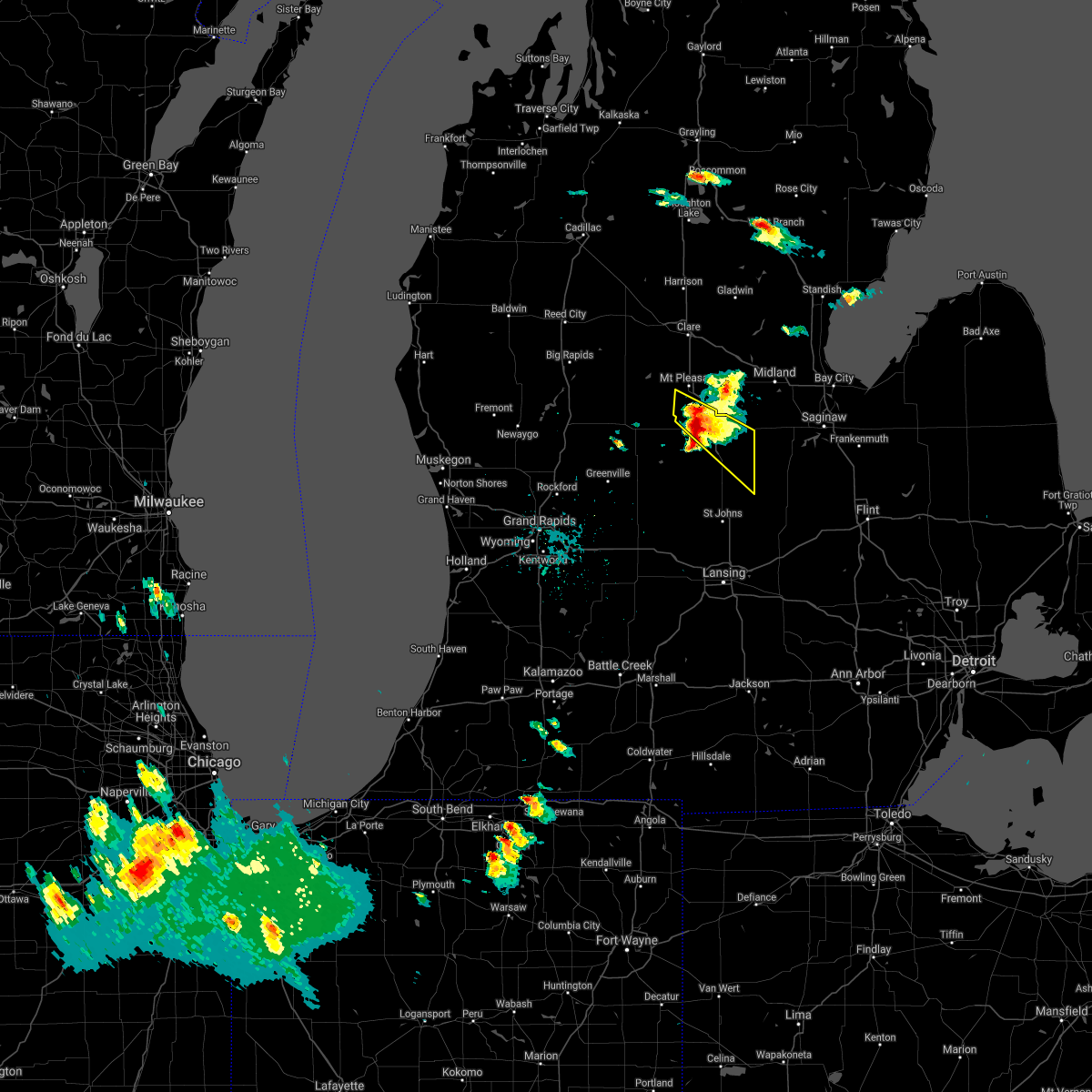
| 8/28/2020 4:30 PM EDT | Golf Ball sized hail reported 0.4 miles SSE of Ashley, MI, ashley fire department reported hail the size of golf balls to central dispatch. time estimated from radar. |
| 8/28/2020 4:24 PM EDT |
 At 424 pm edt, a severe thunderstorm was located 8 miles south of ithaca, moving southeast at 25 mph (radar indicated). Hazards include 60 mph wind gusts. Expect damage to roofs, siding, and trees. Locations impacted include, north star, ashley, perrinton, pompeii, bannister,. At 424 pm edt, a severe thunderstorm was located 8 miles south of ithaca, moving southeast at 25 mph (radar indicated). Hazards include 60 mph wind gusts. Expect damage to roofs, siding, and trees. Locations impacted include, north star, ashley, perrinton, pompeii, bannister,.
|
| 8/28/2020 3:54 PM EDT |
 At 354 pm edt, a severe thunderstorm was located 7 miles north of carson city, or 9 miles west of ithaca, moving east at 35 mph (radar indicated). Hazards include 60 mph wind gusts. expect damage to roofs, siding, and trees At 354 pm edt, a severe thunderstorm was located 7 miles north of carson city, or 9 miles west of ithaca, moving east at 35 mph (radar indicated). Hazards include 60 mph wind gusts. expect damage to roofs, siding, and trees
|
| 7/19/2020 9:36 AM EDT |
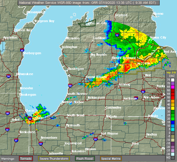 The severe thunderstorm warning for eastern gratiot county will expire at 945 am edt, the storms which prompted the warning have moved out of the area. therefore, the warning will be allowed to expire. cloud to ground lightning will remain a threat to those outdoors for the next hour. The severe thunderstorm warning for eastern gratiot county will expire at 945 am edt, the storms which prompted the warning have moved out of the area. therefore, the warning will be allowed to expire. cloud to ground lightning will remain a threat to those outdoors for the next hour.
|
| 7/19/2020 9:19 AM EDT |
 At 918 am edt, severe thunderstorms were located along a line extending from near breckenridge to near ashley, moving east at 55 mph (radar indicated). Hazards include 60 mph wind gusts. Expect damage to roofs, siding, and trees. Locations impacted include, breckenridge, wheeler, north star, ashley, bannister,. At 918 am edt, severe thunderstorms were located along a line extending from near breckenridge to near ashley, moving east at 55 mph (radar indicated). Hazards include 60 mph wind gusts. Expect damage to roofs, siding, and trees. Locations impacted include, breckenridge, wheeler, north star, ashley, bannister,.
|
| 7/19/2020 8:54 AM EDT |
 At 854 am edt, severe thunderstorms were located along a line extending from 8 miles southwest of shepherd to 7 miles west of carson city, moving east at 45 mph (radar indicated). Hazards include 60 mph wind gusts. expect damage to roofs, siding, and trees At 854 am edt, severe thunderstorms were located along a line extending from 8 miles southwest of shepherd to 7 miles west of carson city, moving east at 45 mph (radar indicated). Hazards include 60 mph wind gusts. expect damage to roofs, siding, and trees
|
| 6/10/2020 1:35 PM EDT |
 At 134 pm edt, severe thunderstorms were located along a line extending from near moddersville to 6 miles east of clare to near breckenridge to near elsie, moving northeast at 45 mph (radar indicated). Hazards include 60 mph wind gusts. Expect damage to roofs, siding, and trees. locations impacted include, mount pleasant, alma, clare, ithaca, st. Louis, shepherd, breckenridge, farwell, rosebush, harrison, wheeler, north star, ashley, perrinton, lake george, forest hill, pompeii, middleton, delwin, loomis,. At 134 pm edt, severe thunderstorms were located along a line extending from near moddersville to 6 miles east of clare to near breckenridge to near elsie, moving northeast at 45 mph (radar indicated). Hazards include 60 mph wind gusts. Expect damage to roofs, siding, and trees. locations impacted include, mount pleasant, alma, clare, ithaca, st. Louis, shepherd, breckenridge, farwell, rosebush, harrison, wheeler, north star, ashley, perrinton, lake george, forest hill, pompeii, middleton, delwin, loomis,.
|
| 6/10/2020 12:51 PM EDT |
 At 1250 pm edt, severe thunderstorms were located along a line extending from 5 miles south of big rapids to 5 miles southeast of stanton, moving northeast at 60 mph (radar indicated). Hazards include 60 mph wind gusts. expect damage to roofs, siding, and trees At 1250 pm edt, severe thunderstorms were located along a line extending from 5 miles south of big rapids to 5 miles southeast of stanton, moving northeast at 60 mph (radar indicated). Hazards include 60 mph wind gusts. expect damage to roofs, siding, and trees
|
| 6/10/2020 12:50 PM EDT | Semi truck blown over on us 127 near m-57. time estimate in gratiot county MI, 4.3 miles ESE of Ashley, MI |
| 6/10/2020 12:28 PM EDT |
 At 1228 pm edt, a severe thunderstorm was located near st. johns, moving northeast at 55 mph (radar indicated). Hazards include 60 mph wind gusts. expect damage to roofs, siding, and trees At 1228 pm edt, a severe thunderstorm was located near st. johns, moving northeast at 55 mph (radar indicated). Hazards include 60 mph wind gusts. expect damage to roofs, siding, and trees
|
| 6/3/2020 1:58 AM EDT |
 At 1252 am edt, severe thunderstorms were located along a line extending from near evart to near ionia, moving east at 50 mph (radar indicated). Hazards include 60 mph wind gusts. expect damage to roofs, siding, and trees At 1252 am edt, severe thunderstorms were located along a line extending from near evart to near ionia, moving east at 50 mph (radar indicated). Hazards include 60 mph wind gusts. expect damage to roofs, siding, and trees
|
| 6/3/2020 12:54 AM EDT |
 At 1252 am edt, severe thunderstorms were located along a line extending from near evart to near ionia, moving east at 50 mph (radar indicated). Hazards include 60 mph wind gusts. expect damage to roofs, siding, and trees At 1252 am edt, severe thunderstorms were located along a line extending from near evart to near ionia, moving east at 50 mph (radar indicated). Hazards include 60 mph wind gusts. expect damage to roofs, siding, and trees
|
| 9/11/2019 7:24 PM EDT |
 At 723 pm edt, a severe thunderstorm was located 8 miles northwest of st. johns, moving east at 35 mph (radar indicated). Hazards include 60 mph wind gusts and quarter size hail. Hail damage to vehicles is expected. expect wind damage to roofs, siding, and trees. Locations impacted include, greenville, ithaca, stanton, carson city, elsie, eureka, crystal, sidney, sumner, maple rapids, sheridan, ashley, perrinton, bannister, fenwick, butternut, kings corner,. At 723 pm edt, a severe thunderstorm was located 8 miles northwest of st. johns, moving east at 35 mph (radar indicated). Hazards include 60 mph wind gusts and quarter size hail. Hail damage to vehicles is expected. expect wind damage to roofs, siding, and trees. Locations impacted include, greenville, ithaca, stanton, carson city, elsie, eureka, crystal, sidney, sumner, maple rapids, sheridan, ashley, perrinton, bannister, fenwick, butternut, kings corner,.
|
| 9/11/2019 6:59 PM EDT |
 At 658 pm edt, a severe thunderstorm was located 7 miles northwest of carson city, or 8 miles east of stanton, moving east at 30 mph. a second severe thunderstorm was located near sand lake, moving east at 30 mph. both storms are capable of producing quarter size hail and 60 mph wind gusts (radar indicated). Hazards include 60 mph wind gusts and quarter size hail. Hail damage to vehicles is expected. Expect wind damage to roofs, siding, and trees. At 658 pm edt, a severe thunderstorm was located 7 miles northwest of carson city, or 8 miles east of stanton, moving east at 30 mph. a second severe thunderstorm was located near sand lake, moving east at 30 mph. both storms are capable of producing quarter size hail and 60 mph wind gusts (radar indicated). Hazards include 60 mph wind gusts and quarter size hail. Hail damage to vehicles is expected. Expect wind damage to roofs, siding, and trees.
|
| 7/29/2019 2:22 PM EDT |
 At 202 pm edt, a severe thunderstorm was located 7 miles west of elsie, or 8 miles north of st. johns, moving east at 50 mph (radar indicated). Hazards include 60 mph wind gusts. expect damage to roofs, siding, and trees At 202 pm edt, a severe thunderstorm was located 7 miles west of elsie, or 8 miles north of st. johns, moving east at 50 mph (radar indicated). Hazards include 60 mph wind gusts. expect damage to roofs, siding, and trees
|
| 7/29/2019 2:02 PM EDT |
 At 202 pm edt, a severe thunderstorm was located 7 miles west of elsie, or 8 miles north of st. johns, moving east at 50 mph (radar indicated). Hazards include 60 mph wind gusts. expect damage to roofs, siding, and trees At 202 pm edt, a severe thunderstorm was located 7 miles west of elsie, or 8 miles north of st. johns, moving east at 50 mph (radar indicated). Hazards include 60 mph wind gusts. expect damage to roofs, siding, and trees
|
| 9/25/2018 7:11 PM EDT |
 The severe thunderstorm warning for southern gratiot and northeastern clinton counties will expire at 715 pm edt, the storm which prompted the warning has weakened below severe limits, and no longer poses an immediate threat to life or property. therefore, the warning will be allowed to expire. The severe thunderstorm warning for southern gratiot and northeastern clinton counties will expire at 715 pm edt, the storm which prompted the warning has weakened below severe limits, and no longer poses an immediate threat to life or property. therefore, the warning will be allowed to expire.
|
| 9/25/2018 6:54 PM EDT |
 At 653 pm edt, a severe thunderstorm was located 6 miles south of ithaca, moving northeast at 45 mph (radar indicated). Hazards include 60 mph wind gusts. Expect damage to roofs, siding, and trees. Locations impacted include, elsie, eureka, maple rapids, ashley, perrinton, bannister,. At 653 pm edt, a severe thunderstorm was located 6 miles south of ithaca, moving northeast at 45 mph (radar indicated). Hazards include 60 mph wind gusts. Expect damage to roofs, siding, and trees. Locations impacted include, elsie, eureka, maple rapids, ashley, perrinton, bannister,.
|
| 9/25/2018 6:31 PM EDT |
 At 631 pm edt, a severe thunderstorm was located 6 miles south of carson city, or 12 miles northeast of ionia, moving northeast at 45 mph (radar indicated). Hazards include 60 mph wind gusts. expect damage to roofs, siding, and trees At 631 pm edt, a severe thunderstorm was located 6 miles south of carson city, or 12 miles northeast of ionia, moving northeast at 45 mph (radar indicated). Hazards include 60 mph wind gusts. expect damage to roofs, siding, and trees
|
| 9/5/2018 6:54 PM EDT |
 At 652 pm edt, a severe thunderstorm was located over ithaca, moving east at 45 mph (radar indicated). Hazards include 60 mph wind gusts. Expect damage to roofs, siding, and trees. Locations impacted include, alma, ithaca, breckenridge, sumner, ashley, perrinton, bannister,. At 652 pm edt, a severe thunderstorm was located over ithaca, moving east at 45 mph (radar indicated). Hazards include 60 mph wind gusts. Expect damage to roofs, siding, and trees. Locations impacted include, alma, ithaca, breckenridge, sumner, ashley, perrinton, bannister,.
|
| 9/5/2018 6:25 PM EDT |
 At 625 pm edt, a severe thunderstorm was located near stanton, moving east at 40 mph (radar indicated). Hazards include 60 mph wind gusts. expect damage to roofs, siding, and trees At 625 pm edt, a severe thunderstorm was located near stanton, moving east at 40 mph (radar indicated). Hazards include 60 mph wind gusts. expect damage to roofs, siding, and trees
|
| 8/2/2018 6:09 PM EDT | Tree limbs down near intersection of baldwin and roosevel in gratiot county MI, 3.6 miles ENE of Ashley, MI |
| 8/2/2018 5:55 PM EDT |
 At 554 pm edt, a severe thunderstorm was located 8 miles north of st. johns, moving northeast at 35 mph (radar indicated). Hazards include 60 mph wind gusts and quarter size hail. Hail damage to vehicles is expected. expect wind damage to roofs, siding, and trees. Locations impacted include, elsie, eureka, fowler, maple rapids, ashley, perrinton, bannister,. At 554 pm edt, a severe thunderstorm was located 8 miles north of st. johns, moving northeast at 35 mph (radar indicated). Hazards include 60 mph wind gusts and quarter size hail. Hail damage to vehicles is expected. expect wind damage to roofs, siding, and trees. Locations impacted include, elsie, eureka, fowler, maple rapids, ashley, perrinton, bannister,.
|
| 8/2/2018 5:39 PM EDT |
 At 538 pm edt, a severe thunderstorm was located 9 miles south of carson city, or 12 miles west of st. johns, moving northeast at 30 mph (radar indicated). Hazards include 60 mph wind gusts and quarter size hail. Hail damage to vehicles is expected. Expect wind damage to roofs, siding, and trees. At 538 pm edt, a severe thunderstorm was located 9 miles south of carson city, or 12 miles west of st. johns, moving northeast at 30 mph (radar indicated). Hazards include 60 mph wind gusts and quarter size hail. Hail damage to vehicles is expected. Expect wind damage to roofs, siding, and trees.
|
| 6/17/2017 4:40 PM EDT | Four trees down in elba township. time estimated from rada in gratiot county MI, 4.6 miles WNW of Ashley, MI |
| 8/20/2016 4:39 PM EDT |
 At 438 pm edt, severe thunderstorms were located along a line extending from near beaverton to near breckenridge to 9 miles north of st. johns, moving northeast at 40 mph (radar indicated). Hazards include 60 mph wind gusts. Expect damage to roofs. siding. and trees. locations impacted include, alma, st. johns, ithaca, st. Louis, breckenridge, elsie, eureka, wheeler, fowler, westphalia, maple rapids, ashley, perrinton, bannister,. At 438 pm edt, severe thunderstorms were located along a line extending from near beaverton to near breckenridge to 9 miles north of st. johns, moving northeast at 40 mph (radar indicated). Hazards include 60 mph wind gusts. Expect damage to roofs. siding. and trees. locations impacted include, alma, st. johns, ithaca, st. Louis, breckenridge, elsie, eureka, wheeler, fowler, westphalia, maple rapids, ashley, perrinton, bannister,.
|
| 8/20/2016 4:14 PM EDT |
 At 413 pm edt, severe thunderstorms were located along a line extending from rosebush to 8 miles south of ithaca to 9 miles northeast of portland, moving northeast at 40 mph (radar indicated). Hazards include 60 mph wind gusts. Expect damage to roofs. siding. And trees. At 413 pm edt, severe thunderstorms were located along a line extending from rosebush to 8 miles south of ithaca to 9 miles northeast of portland, moving northeast at 40 mph (radar indicated). Hazards include 60 mph wind gusts. Expect damage to roofs. siding. And trees.
|
| 8/20/2016 4:00 PM EDT |
 At 359 pm edt, severe thunderstorms were located along a line extending from rosebush to pleasant valley to 5 miles southwest of ithaca, moving northeast at 55 mph (radar indicated). Hazards include 60 mph wind gusts. Expect damage to roofs. siding. and trees. locations impacted include, mount pleasant, alma, st. johns, clare, ithaca, st. Louis, shepherd, breckenridge, carson city, elsie, rosebush, eureka, wheeler, sumner, fowler, westphalia, maple rapids, ashley, perrinton, hubbardston,. At 359 pm edt, severe thunderstorms were located along a line extending from rosebush to pleasant valley to 5 miles southwest of ithaca, moving northeast at 55 mph (radar indicated). Hazards include 60 mph wind gusts. Expect damage to roofs. siding. and trees. locations impacted include, mount pleasant, alma, st. johns, clare, ithaca, st. Louis, shepherd, breckenridge, carson city, elsie, rosebush, eureka, wheeler, sumner, fowler, westphalia, maple rapids, ashley, perrinton, hubbardston,.
|
| 8/20/2016 3:33 PM EDT |
 At 332 pm edt, severe thunderstorms were located along a line extending from edmore to carson city to near ionia, moving northeast at 55 mph (radar indicated). Hazards include 60 mph wind gusts. Expect damage to roofs. siding. And trees. At 332 pm edt, severe thunderstorms were located along a line extending from edmore to carson city to near ionia, moving northeast at 55 mph (radar indicated). Hazards include 60 mph wind gusts. Expect damage to roofs. siding. And trees.
|
| 10/24/2015 2:56 PM EDT |
 At 255 pm edt, severe thunderstorms were located along a line extending from near shepherd to ionia, moving northeast at 40 mph (radar indicated). Hazards include 60 mph wind gusts. Expect damage to roofs. Siding and trees. At 255 pm edt, severe thunderstorms were located along a line extending from near shepherd to ionia, moving northeast at 40 mph (radar indicated). Hazards include 60 mph wind gusts. Expect damage to roofs. Siding and trees.
|
| 9/3/2015 4:33 PM EDT |
 At 432 pm edt, severe thunderstorms were located along a line extending from stanton to near ithaca, moving southeast at 5 mph (radar indicated). Hazards include 60 mph wind gusts. Expect damage to roofs. siding and trees. Locations impacted include, alma, ithaca, stanton, edmore, carson city, crystal, sumner, sheridan, ashley, perrinton, mcbride, kings corner, fenwick, butternut, bannister, elm hall,. At 432 pm edt, severe thunderstorms were located along a line extending from stanton to near ithaca, moving southeast at 5 mph (radar indicated). Hazards include 60 mph wind gusts. Expect damage to roofs. siding and trees. Locations impacted include, alma, ithaca, stanton, edmore, carson city, crystal, sumner, sheridan, ashley, perrinton, mcbride, kings corner, fenwick, butternut, bannister, elm hall,.
|
| 9/3/2015 4:09 PM EDT |
 At 408 pm edt, severe thunderstorms were located along a line extending from near stanton to near ithaca, moving southeast at 25 mph (radar indicated). Hazards include 60 mph wind gusts. Expect damage to roofs. Siding and trees. At 408 pm edt, severe thunderstorms were located along a line extending from near stanton to near ithaca, moving southeast at 25 mph (radar indicated). Hazards include 60 mph wind gusts. Expect damage to roofs. Siding and trees.
|
| 8/2/2015 9:04 PM EDT |
 At 903 pm edt, a severe thunderstorm was located near marion springs, moving east at 65 mph (radar indicated). Hazards include 60 mph wind gusts and quarter size hail. Hail damage to vehicles is expected. Expect wind damage to roofs, siding and trees. At 903 pm edt, a severe thunderstorm was located near marion springs, moving east at 65 mph (radar indicated). Hazards include 60 mph wind gusts and quarter size hail. Hail damage to vehicles is expected. Expect wind damage to roofs, siding and trees.
|
| 7/3/2012 6:00 AM EDT | Large downed tree in saginaw county MI, 8.4 miles WSW of Ashley, MI |
Hail Maps for Ashley, MI


Connect with Interactive Hail Maps