

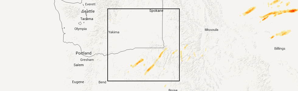
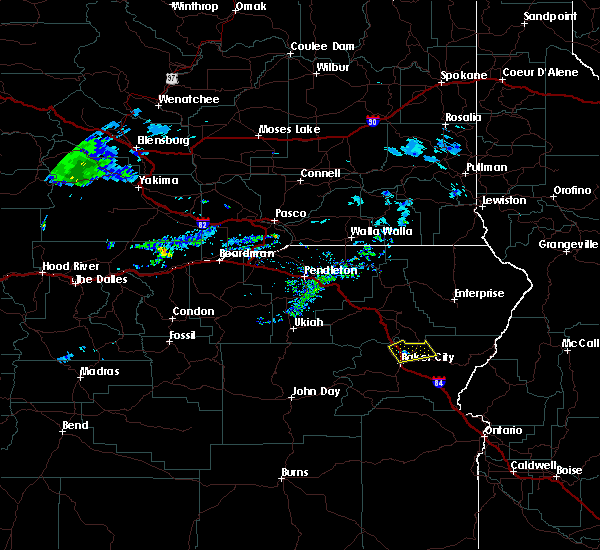
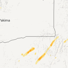
Hail Map for Baker City, OR
The Baker City, OR area has had 6 reports of on-the-ground hail by trained spotters, and has been under severe weather warnings 0 times during the past 12 months. Doppler radar has detected hail at or near Baker City, OR on 1 occasion.
| Name: | Baker City, OR |
| Where Located: | 92.5 miles SSE of Walla Walla, WA |
| Map: | Google Map for Baker City, OR |
| Population: | 9828 |
| Housing Units: | 4653 |
| More Info: | Search Google for Baker City, OR |
0
The Top Recent Hail Date for Baker City, OR is Saturday, July 16, 2011 (1st out of 1)
Hail and Wind Damage Spotted near Baker City, OR
| Date / Time | Report Details |
|---|---|
| 5/16/2023 2:15 PM PDT | Quarter sized hail reported 2.1 miles N of Baker City, OR, hail covered the ground south of the city. mostly small hail pea to dime but there were a few quarter size hail stones. |
| 4/29/2020 6:39 PM PDT | Quarter sized hail reported 0.7 miles NNE of Baker City, OR, emergency manager reported quarter-sized hail at his office at 625 pm pdt. |
| 4/29/2020 6:34 PM PDT |
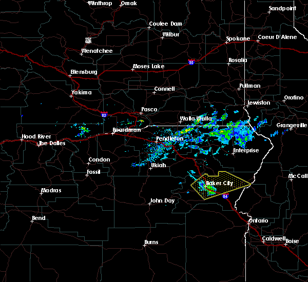 At 628 pm pdt, a severe thunderstorm was located over flagstaff hill, or 7 miles northeast of baker city, moving northeast at 30 mph. a second potentially severe cell was located 5 miles south of baker city, also moving northeast at 30 mph (radar indicated). Hazards include 60 mph wind gusts and quarter size hail. Hail damage to vehicles is expected. expect wind damage to roofs, siding, and trees. this severe thunderstorm will be near, keating and love reservoir around 640 pm pdt. little lookout mountain around 650 pm pdt. gover reservoir, tamarack campground and sparta around 700 pm pdt. richland around 710 pm pdt. Carson and halfway around 720 pm pdt. At 628 pm pdt, a severe thunderstorm was located over flagstaff hill, or 7 miles northeast of baker city, moving northeast at 30 mph. a second potentially severe cell was located 5 miles south of baker city, also moving northeast at 30 mph (radar indicated). Hazards include 60 mph wind gusts and quarter size hail. Hail damage to vehicles is expected. expect wind damage to roofs, siding, and trees. this severe thunderstorm will be near, keating and love reservoir around 640 pm pdt. little lookout mountain around 650 pm pdt. gover reservoir, tamarack campground and sparta around 700 pm pdt. richland around 710 pm pdt. Carson and halfway around 720 pm pdt.
|
| 4/29/2020 6:29 PM PDT |
 At 628 pm pdt, a severe thunderstorm was located over flagstaff hill, or 7 miles northeast of baker city, moving northeast at 30 mph. a second potentially severe cell was located 5 miles south of baker city, also moving northeast at 30 mph (radar indicated). Hazards include 60 mph wind gusts and quarter size hail. Hail damage to vehicles is expected. expect wind damage to roofs, siding, and trees. this severe thunderstorm will be near, keating and love reservoir around 640 pm pdt. little lookout mountain around 650 pm pdt. gover reservoir, tamarack campground and sparta around 700 pm pdt. richland around 710 pm pdt. Carson and halfway around 720 pm pdt. At 628 pm pdt, a severe thunderstorm was located over flagstaff hill, or 7 miles northeast of baker city, moving northeast at 30 mph. a second potentially severe cell was located 5 miles south of baker city, also moving northeast at 30 mph (radar indicated). Hazards include 60 mph wind gusts and quarter size hail. Hail damage to vehicles is expected. expect wind damage to roofs, siding, and trees. this severe thunderstorm will be near, keating and love reservoir around 640 pm pdt. little lookout mountain around 650 pm pdt. gover reservoir, tamarack campground and sparta around 700 pm pdt. richland around 710 pm pdt. Carson and halfway around 720 pm pdt.
|
| 4/29/2020 5:55 PM PDT |
 At 555 pm pdt, a severe thunderstorm was located over larch summit, or 17 miles west of baker city, moving northeast at 40 mph (radar indicated). Hazards include 60 mph wind gusts and quarter size hail. Hail damage to vehicles is expected. expect wind damage to roofs, siding, and trees. this severe storm will be near, mcewen and phillips reservoir around 600 pm pdt. elkhorn peak, mason dam, salisbury and anthony lakes ski area around 610 pm pdt. haines around 620 pm pdt. Baker city and flagstaff hill around 630 pm pdt. At 555 pm pdt, a severe thunderstorm was located over larch summit, or 17 miles west of baker city, moving northeast at 40 mph (radar indicated). Hazards include 60 mph wind gusts and quarter size hail. Hail damage to vehicles is expected. expect wind damage to roofs, siding, and trees. this severe storm will be near, mcewen and phillips reservoir around 600 pm pdt. elkhorn peak, mason dam, salisbury and anthony lakes ski area around 610 pm pdt. haines around 620 pm pdt. Baker city and flagstaff hill around 630 pm pdt.
|
| 4/29/2020 5:26 PM PDT |
 At 526 pm pdt, a severe thunderstorm was located near bates, or 27 miles northeast of john day, moving northeast at 40 mph (radar indicated). Hazards include 60 mph wind gusts and quarter size hail. Hail damage to vehicles is expected. expect wind damage to roofs, siding, and trees. this severe thunderstorm will be near, blue mountain pass around 530 pm pdt. antlers forest service station and unity reservoir around 540 pm pdt. sumpter, larch summit and mcewen around 550 pm pdt. elkhorn peak, mount ruth, anthony lakes ski area and phillips reservoir around 600 pm pdt. Salisbury around 610 pm pdt. At 526 pm pdt, a severe thunderstorm was located near bates, or 27 miles northeast of john day, moving northeast at 40 mph (radar indicated). Hazards include 60 mph wind gusts and quarter size hail. Hail damage to vehicles is expected. expect wind damage to roofs, siding, and trees. this severe thunderstorm will be near, blue mountain pass around 530 pm pdt. antlers forest service station and unity reservoir around 540 pm pdt. sumpter, larch summit and mcewen around 550 pm pdt. elkhorn peak, mount ruth, anthony lakes ski area and phillips reservoir around 600 pm pdt. Salisbury around 610 pm pdt.
|
| 6/13/2019 1:18 PM PDT | Half Dollar sized hail reported 10.4 miles N of Baker City, OR, hail covered the ground along highway 245 near stices gulch. hail sizes were up to 1.25 inches. |
| 5/25/2018 7:17 PM PDT |
 At 816 pm mdt/716 pm pdt/, severe thunderstorms were located along a line extending from near anthony lakes ski area to mcchord butte, moving north at 25 mph (radar indicated). Hazards include 70 mph wind gusts and quarter size hail. Hail damage to vehicles is expected. expect considerable tree damage. wind damage is also likely to mobile homes, roofs, and outbuildings. these severe storms will be near, anthony lakes ski area, mount ruth, haines and flagstaff hill around 720 pm pdt. north powder and thief valley reservoir around 730 pm pdt. Richland, brownlee dam, halfway and carson around 740 pm pdt. At 816 pm mdt/716 pm pdt/, severe thunderstorms were located along a line extending from near anthony lakes ski area to mcchord butte, moving north at 25 mph (radar indicated). Hazards include 70 mph wind gusts and quarter size hail. Hail damage to vehicles is expected. expect considerable tree damage. wind damage is also likely to mobile homes, roofs, and outbuildings. these severe storms will be near, anthony lakes ski area, mount ruth, haines and flagstaff hill around 720 pm pdt. north powder and thief valley reservoir around 730 pm pdt. Richland, brownlee dam, halfway and carson around 740 pm pdt.
|
| 5/25/2018 7:17 PM PDT |
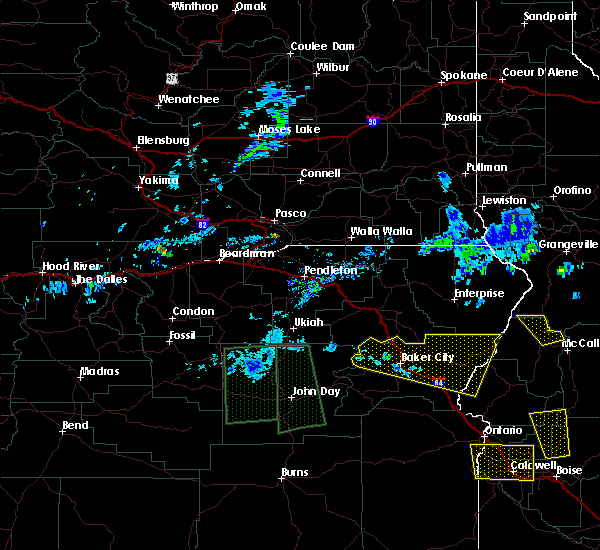 At 816 pm mdt/716 pm pdt/, severe thunderstorms were located along a line extending from near anthony lakes ski area to mcchord butte, moving north at 25 mph (radar indicated). Hazards include 70 mph wind gusts and quarter size hail. Hail damage to vehicles is expected. expect considerable tree damage. wind damage is also likely to mobile homes, roofs, and outbuildings. these severe storms will be near, anthony lakes ski area, mount ruth, haines and flagstaff hill around 720 pm pdt. north powder and thief valley reservoir around 730 pm pdt. Richland, brownlee dam, halfway and carson around 740 pm pdt. At 816 pm mdt/716 pm pdt/, severe thunderstorms were located along a line extending from near anthony lakes ski area to mcchord butte, moving north at 25 mph (radar indicated). Hazards include 70 mph wind gusts and quarter size hail. Hail damage to vehicles is expected. expect considerable tree damage. wind damage is also likely to mobile homes, roofs, and outbuildings. these severe storms will be near, anthony lakes ski area, mount ruth, haines and flagstaff hill around 720 pm pdt. north powder and thief valley reservoir around 730 pm pdt. Richland, brownlee dam, halfway and carson around 740 pm pdt.
|
| 5/25/2018 6:44 PM PDT |
 At 744 pm mdt/644 pm pdt/, severe thunderstorms were located along a line extending from near greenhorn to 6 miles southwest of mcchord butte, moving north at 20 mph (radar indicated). Hazards include 70 mph wind gusts and quarter size hail. Hail damage to vehicles is expected. expect considerable tree damage. wind damage is also likely to mobile homes, roofs, and outbuildings. severe thunderstorms will be near, dixie, henley basin, weatherby and durkee around 650 pm pdt. sweedes landing, mcchord butte, big lookout mountain and pleasant valley around 700 pm pdt. baker city, little lookout mountain, sumpter and mason dam around 710 pm pdt. sheep mountain, love reservoir and flagstaff hill around 720 pm pdt. Elkhorn peak around 730 pm pdt. At 744 pm mdt/644 pm pdt/, severe thunderstorms were located along a line extending from near greenhorn to 6 miles southwest of mcchord butte, moving north at 20 mph (radar indicated). Hazards include 70 mph wind gusts and quarter size hail. Hail damage to vehicles is expected. expect considerable tree damage. wind damage is also likely to mobile homes, roofs, and outbuildings. severe thunderstorms will be near, dixie, henley basin, weatherby and durkee around 650 pm pdt. sweedes landing, mcchord butte, big lookout mountain and pleasant valley around 700 pm pdt. baker city, little lookout mountain, sumpter and mason dam around 710 pm pdt. sheep mountain, love reservoir and flagstaff hill around 720 pm pdt. Elkhorn peak around 730 pm pdt.
|
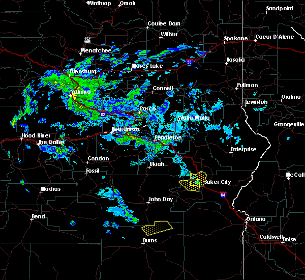
| 5/25/2018 6:14 PM PDT |
 At 713 pm mdt/613 pm pdt/, severe thunderstorms were located along a line extending from near bates to near dooley summit, moving north at 35 mph (radar indicated). Hazards include 60 mph wind gusts and quarter size hail. Hail damage to vehicles is expected. expect wind damage to roofs, siding, and trees. these severe storms will be near, antlers forest service station around 620 pm pdt. greenhorn, salisbury, mason dam and larch summit around 630 pm pdt. Baker city around 640 pm pdt. At 713 pm mdt/613 pm pdt/, severe thunderstorms were located along a line extending from near bates to near dooley summit, moving north at 35 mph (radar indicated). Hazards include 60 mph wind gusts and quarter size hail. Hail damage to vehicles is expected. expect wind damage to roofs, siding, and trees. these severe storms will be near, antlers forest service station around 620 pm pdt. greenhorn, salisbury, mason dam and larch summit around 630 pm pdt. Baker city around 640 pm pdt.
|
| 5/25/2018 5:38 PM PDT |
 At 638 pm mdt/538 pm pdt/, a severe thunderstorm was located near eldorado pass, or 33 miles south of baker city, moving north at 20 mph (radar indicated). Hazards include 60 mph wind gusts and quarter size hail. Hail damage to vehicles is expected. expect wind damage to roofs, siding, and trees. this severe thunderstorm will be near, short creek forest service station around 640 pm mdt. eldorado pass and bullrun rock around 650 pm mdt. baldy mountain and elk creek campground around 600 pm pdt. unity around 610 pm pdt. Unity dam and unity reservoir around 620 pm pdt. At 638 pm mdt/538 pm pdt/, a severe thunderstorm was located near eldorado pass, or 33 miles south of baker city, moving north at 20 mph (radar indicated). Hazards include 60 mph wind gusts and quarter size hail. Hail damage to vehicles is expected. expect wind damage to roofs, siding, and trees. this severe thunderstorm will be near, short creek forest service station around 640 pm mdt. eldorado pass and bullrun rock around 650 pm mdt. baldy mountain and elk creek campground around 600 pm pdt. unity around 610 pm pdt. Unity dam and unity reservoir around 620 pm pdt.
|
| 5/6/2018 1:54 PM PDT |
 At 154 pm pdt, a severe thunderstorm was located near haines, or 7 miles northwest of baker city, moving north at 35 mph (radar indicated). Hazards include 60 mph wind gusts and quarter size hail. Hail damage to vehicles is expected. expect wind damage to roofs, siding, and trees. this severe thunderstorm will be near, haines around 200 pm pdt. North powder and thief valley reservoir around 220 pm pdt. At 154 pm pdt, a severe thunderstorm was located near haines, or 7 miles northwest of baker city, moving north at 35 mph (radar indicated). Hazards include 60 mph wind gusts and quarter size hail. Hail damage to vehicles is expected. expect wind damage to roofs, siding, and trees. this severe thunderstorm will be near, haines around 200 pm pdt. North powder and thief valley reservoir around 220 pm pdt.
|
| 5/5/2018 6:11 PM PDT |
 At 611 pm pdt, a severe thunderstorm was located 7 miles east of haines, or 9 miles north of baker city, moving northeast at 15 mph (emergency management). Hazards include quarter size hail. Damage to vehicles is expected. This severe thunderstorm will be near, keating around 640 pm pdt. At 611 pm pdt, a severe thunderstorm was located 7 miles east of haines, or 9 miles north of baker city, moving northeast at 15 mph (emergency management). Hazards include quarter size hail. Damage to vehicles is expected. This severe thunderstorm will be near, keating around 640 pm pdt.
|
| 4/7/2018 11:45 AM PDT | Flagstaff hill raws reported thunderstorm wind gust to 66 mp in baker county OR, 5.2 miles WSW of Baker City, OR |
| 4/7/2018 11:40 AM PDT | Several large trees uprooted around the town of baker city via social medi in baker county OR, 0.7 miles NNE of Baker City, OR |
| 4/7/2018 11:38 AM PDT | Downed power lines caused 1778 customers to lose powe in baker county OR, 0.7 miles NNE of Baker City, OR |
| 4/7/2018 11:31 AM PDT | Public reported power lines down at 8th and campbell streets in baker county OR, 0.7 miles NNE of Baker City, OR |
| 4/7/2018 11:30 AM PDT | Public reported large tree snapped at washington ave and east stree in baker county OR, 0.7 miles NNE of Baker City, OR |
| 8/30/2017 2:15 PM PDT | A trained spotter reported rainfall of 0.10 inch in 10 minutes... wind spead at 12 mph with gusts to 21 mph ... and a very bief period with dime-sized hail. baker city in baker county OR, 0.7 miles NNE of Baker City, OR |
| 5/16/2017 1:42 PM PDT | Trees knocked down from thunderstorm winds. social media phot in baker county OR, 14.6 miles SW of Baker City, OR |
| 7/12/2016 4:45 PM PDT | Quarter sized hail reported 8.2 miles SSE of Baker City, OR, a trained spotter reported occasional 1 inch hail associated with a strong thunderstorm moving through the area. most of the hail that fell was from 1/4 to 3/4 inches i |
| 3/1/2016 9:29 PM PST | Squall thunderstorm on cold fron in baker county OR, 0.7 miles NNE of Baker City, OR |
| 3/11/2012 11:55 AM PDT | Flagstaff hill raw in baker county OR, 5.6 miles WSW of Baker City, OR |
| 1/1/0001 12:00 AM | Quarter sized hail reported 8.6 miles ESE of Baker City, OR |
| 1/1/0001 12:00 AM | Quarter sized hail reported 9.9 miles ESE of Baker City, OR, trained spotter reported nickel and quarter-sized hail. hail was still falling and accumulating on the ground at time of report. |
Hail Maps for Baker City, OR
Connect with Interactive Hail Maps