

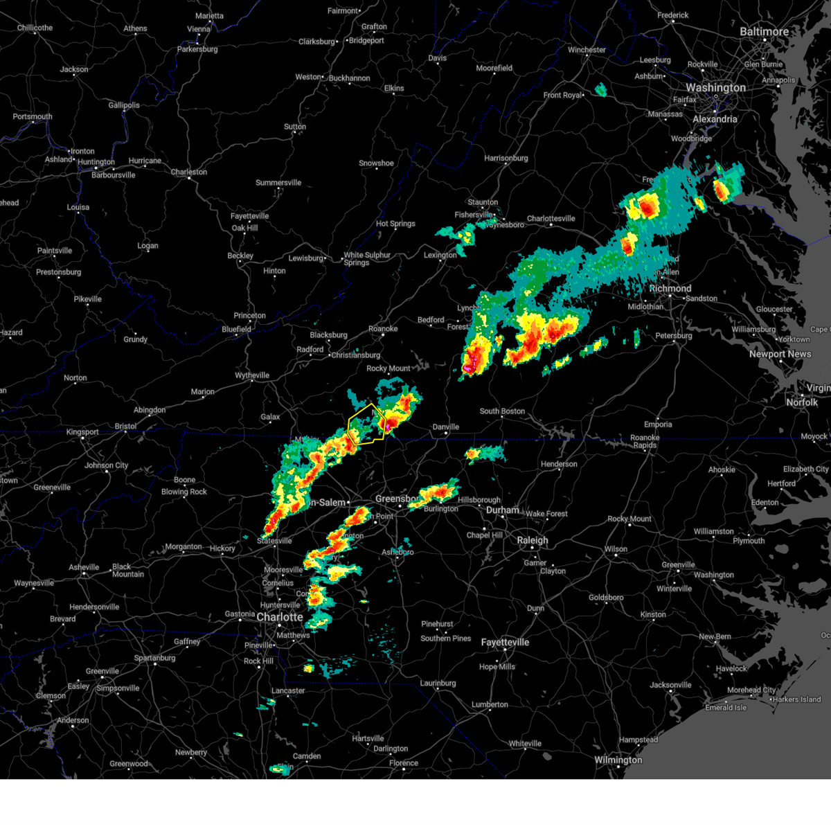
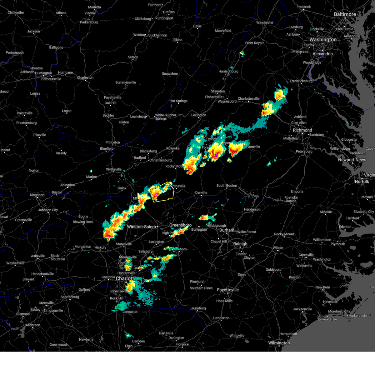
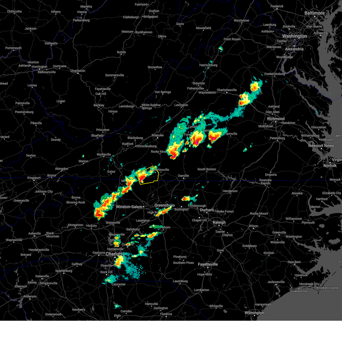
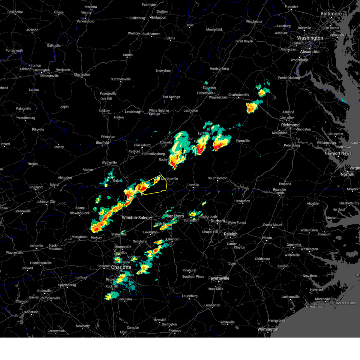
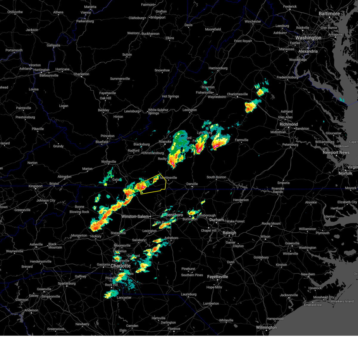
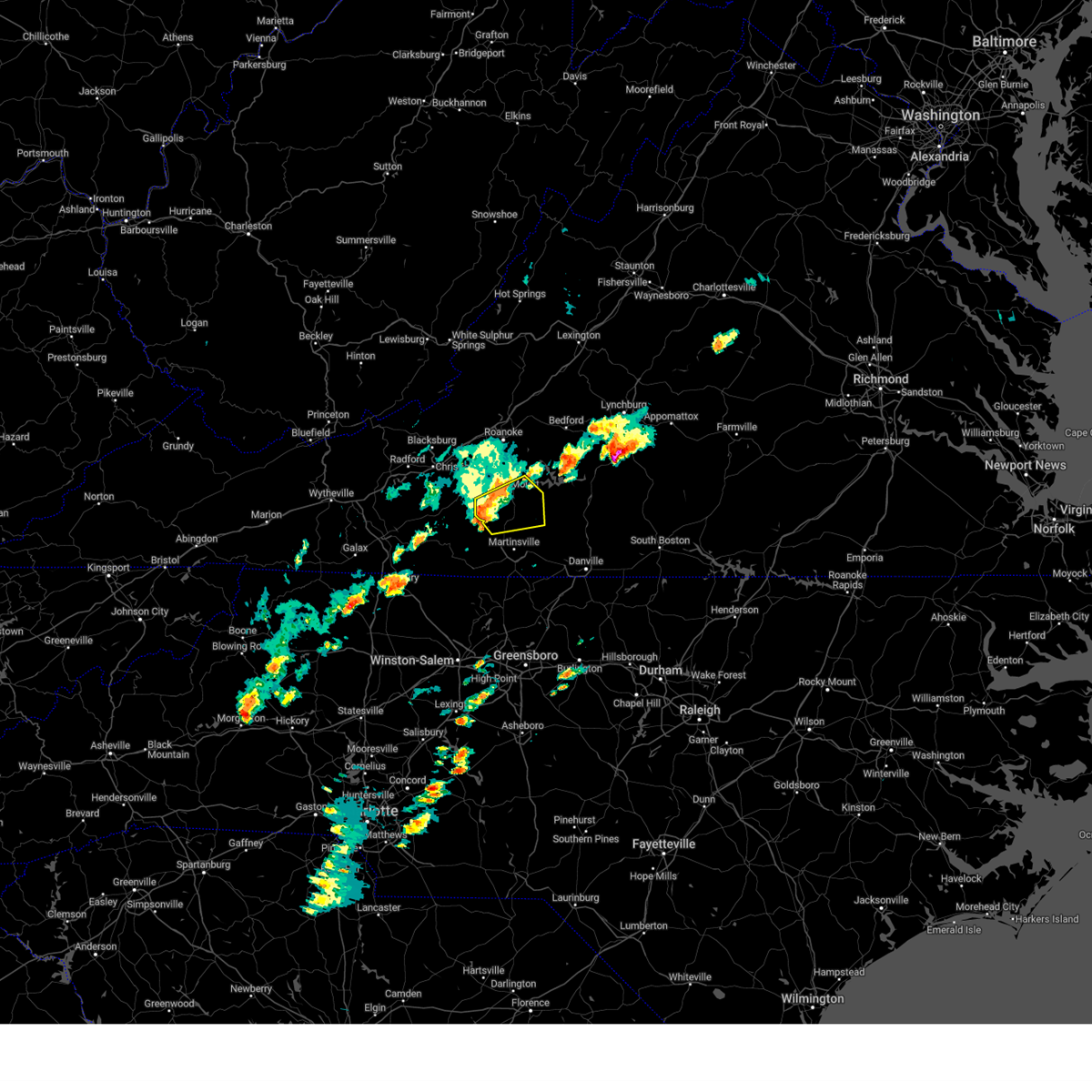
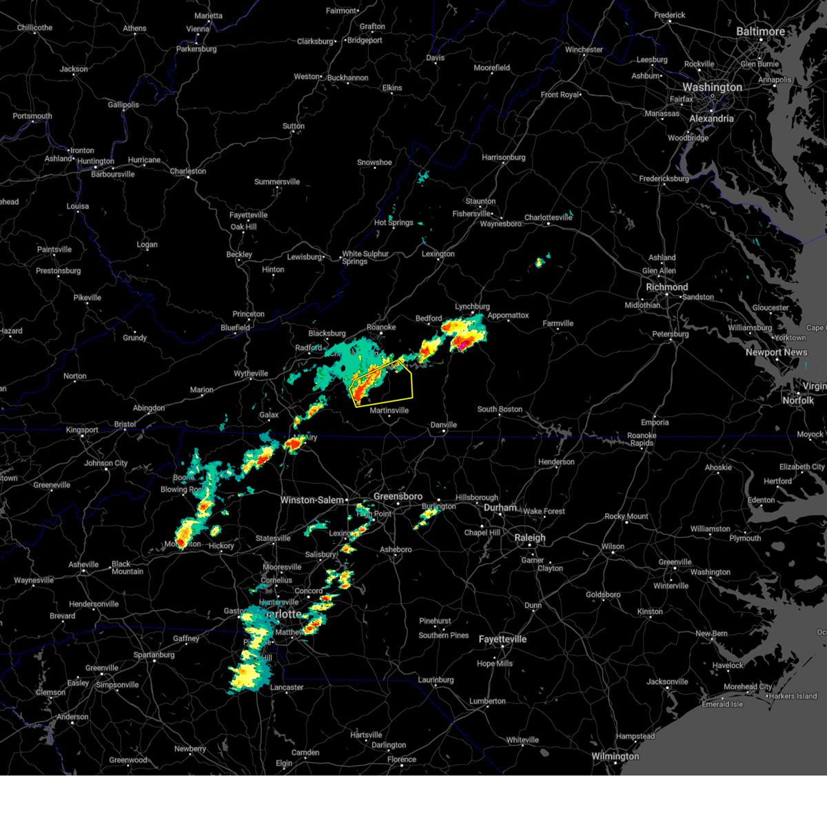
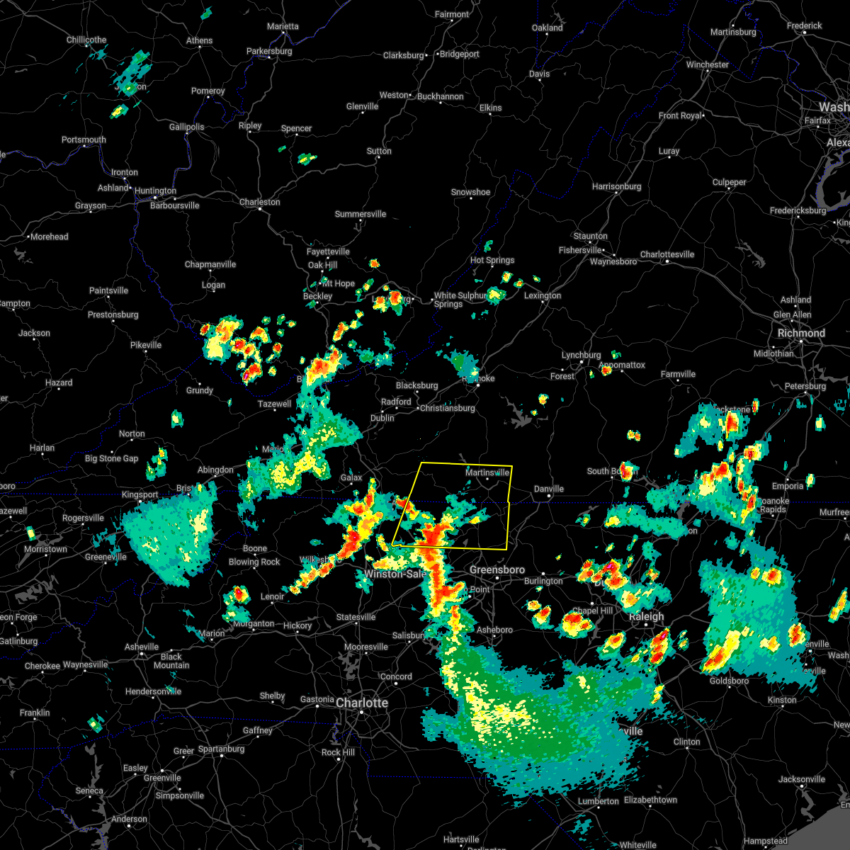
Hail Map for Bassett, VA
The Bassett, VA area has had 6 reports of on-the-ground hail by trained spotters, and has been under severe weather warnings 31 times during the past 12 months. Doppler radar has detected hail at or near Bassett, VA on 44 occasions, including 3 occasions during the past year.
| Name: | Bassett, VA |
| Where Located: | 35 miles S of Roanoke, VA |
| Map: | Google Map for Bassett, VA |
| Population: | 1100 |
| Housing Units: | 607 |
| More Info: | Search Google for Bassett, VA |
0
The Top Recent Hail Date for Bassett, VA is Thursday, August 24, 2023 (18th out of 44)

Hail and Wind Damage Spotted near Bassett, VA
| Date / Time | Report Details |
|---|---|
| 4/11/2024 9:17 PM EDT | Tree down in the 2400 block of philpott drive in the bassett are in henry county VA, 2.4 miles S of Bassett, VA |
| 4/11/2024 9:15 PM EDT |
 the severe thunderstorm warning has been cancelled and is no longer in effect the severe thunderstorm warning has been cancelled and is no longer in effect
|
| 4/11/2024 8:37 PM EDT |
 Svrrnk the national weather service in blacksburg has issued a * severe thunderstorm warning for, northeastern floyd county in southwestern virginia, the city of martinsville in south central virginia, northwestern henry county in south central virginia, eastern patrick county in southwestern virginia, southwestern franklin county in west central virginia, * until 930 pm edt. * at 837 pm edt, severe thunderstorms were located along a line extending from floyd to near fairy stone state park to critz, moving northeast at 50 mph (radar indicated). Hazards include 60 mph wind gusts. expect damage to roofs, siding, and trees Svrrnk the national weather service in blacksburg has issued a * severe thunderstorm warning for, northeastern floyd county in southwestern virginia, the city of martinsville in south central virginia, northwestern henry county in south central virginia, eastern patrick county in southwestern virginia, southwestern franklin county in west central virginia, * until 930 pm edt. * at 837 pm edt, severe thunderstorms were located along a line extending from floyd to near fairy stone state park to critz, moving northeast at 50 mph (radar indicated). Hazards include 60 mph wind gusts. expect damage to roofs, siding, and trees
|
| 1/9/2024 2:25 PM EST |
 The tornado warning for henry county and the city of martinsville will expire at 230 pm est, the tornado threat has diminished and the tornado warning has been cancelled. however, large hail and damaging winds remain likely and a severe thunderstorm warning remains in effect for the area. gusty winds are still possible with this thunderstorm. a tornado watch remains in effect until 900 pm est for north central north carolina, and south central virginia. The tornado warning for henry county and the city of martinsville will expire at 230 pm est, the tornado threat has diminished and the tornado warning has been cancelled. however, large hail and damaging winds remain likely and a severe thunderstorm warning remains in effect for the area. gusty winds are still possible with this thunderstorm. a tornado watch remains in effect until 900 pm est for north central north carolina, and south central virginia.
|
| 1/9/2024 2:17 PM EST | Trees and power lines blown down by thunderstorm winds near figsboro road and snyder hollow roa in henry county VA, 7.2 miles WSW of Bassett, VA |
| 1/9/2024 2:12 PM EST |
 At 211 pm est, a severe thunderstorm capable of producing a tornado was located over horse pasture, or near martinsville, moving northeast at 55 mph (radar indicated rotation). Hazards include tornado. Flying debris will be dangerous to those caught without shelter. mobile homes will be damaged or destroyed. damage to roofs, windows, and vehicles will occur. tree damage is likely. locations impacted include, martinsville, spencer, bassett, ridgeway, leatherwood, villa heights, and chatmoss. This includes the following locations the martinsville speedway and martinsville airport. At 211 pm est, a severe thunderstorm capable of producing a tornado was located over horse pasture, or near martinsville, moving northeast at 55 mph (radar indicated rotation). Hazards include tornado. Flying debris will be dangerous to those caught without shelter. mobile homes will be damaged or destroyed. damage to roofs, windows, and vehicles will occur. tree damage is likely. locations impacted include, martinsville, spencer, bassett, ridgeway, leatherwood, villa heights, and chatmoss. This includes the following locations the martinsville speedway and martinsville airport.
|
| 1/9/2024 2:04 PM EST |
 At 203 pm est, a severe thunderstorm capable of producing a tornado was located near ayersville, or near spencer, moving northeast at 55 mph (radar indicated rotation). Hazards include tornado. Flying debris will be dangerous to those caught without shelter. mobile homes will be damaged or destroyed. damage to roofs, windows, and vehicles will occur. tree damage is likely. locations impacted include, martinsville, spencer, axton, bassett, ridgeway, leatherwood, and villa heights. This includes the following locations the martinsville speedway and martinsville airport. At 203 pm est, a severe thunderstorm capable of producing a tornado was located near ayersville, or near spencer, moving northeast at 55 mph (radar indicated rotation). Hazards include tornado. Flying debris will be dangerous to those caught without shelter. mobile homes will be damaged or destroyed. damage to roofs, windows, and vehicles will occur. tree damage is likely. locations impacted include, martinsville, spencer, axton, bassett, ridgeway, leatherwood, and villa heights. This includes the following locations the martinsville speedway and martinsville airport.
|
| 1/9/2024 1:57 PM EST |
 At 157 pm est, a severe thunderstorm capable of producing a tornado was located over sandy ridge, moving northeast at 55 mph (radar indicated rotation). Hazards include tornado. Flying debris will be dangerous to those caught without shelter. mobile homes will be damaged or destroyed. damage to roofs, windows, and vehicles will occur. Tree damage is likely. At 157 pm est, a severe thunderstorm capable of producing a tornado was located over sandy ridge, moving northeast at 55 mph (radar indicated rotation). Hazards include tornado. Flying debris will be dangerous to those caught without shelter. mobile homes will be damaged or destroyed. damage to roofs, windows, and vehicles will occur. Tree damage is likely.
|
| 9/9/2023 1:19 PM EDT |
 At 118 pm edt, a severe thunderstorm was located over critz, or 7 miles northwest of spencer, moving northeast at 10 mph (radar indicated). Hazards include quarter size hail. frequent dangerous cloud-to-ground lightning. very heavy rainfall. Damage to vehicles is expected. Minor flooding. At 118 pm edt, a severe thunderstorm was located over critz, or 7 miles northwest of spencer, moving northeast at 10 mph (radar indicated). Hazards include quarter size hail. frequent dangerous cloud-to-ground lightning. very heavy rainfall. Damage to vehicles is expected. Minor flooding.
|
| 9/7/2023 10:57 PM EDT |
 At 1057 pm edt, a severe thunderstorm was located over martinsville, moving northeast at 20 mph (radar indicated). Hazards include 60 mph wind gusts and quarter size hail. Hail damage to vehicles is expected. expect wind damage to roofs, siding, and trees. locations impacted include, martinsville, bassett, sydnorsville, snow creek, stanleytown, leatherwood, and villa heights. hail threat, radar indicated max hail size, 1. 00 in wind threat, radar indicated max wind gust, 60 mph. At 1057 pm edt, a severe thunderstorm was located over martinsville, moving northeast at 20 mph (radar indicated). Hazards include 60 mph wind gusts and quarter size hail. Hail damage to vehicles is expected. expect wind damage to roofs, siding, and trees. locations impacted include, martinsville, bassett, sydnorsville, snow creek, stanleytown, leatherwood, and villa heights. hail threat, radar indicated max hail size, 1. 00 in wind threat, radar indicated max wind gust, 60 mph.
|
| 9/7/2023 10:33 PM EDT |
 At 1033 pm edt, a severe thunderstorm was located over figsboro, or near martinsville, moving northeast at 20 mph (radar indicated). Hazards include 60 mph wind gusts. Expect damage to roofs, siding, and trees. locations impacted include, martinsville, bassett, sydnorsville, snow creek, stanleytown, leatherwood, and villa heights. hail threat, radar indicated max hail size, <. 75 in wind threat, radar indicated max wind gust, 60 mph. At 1033 pm edt, a severe thunderstorm was located over figsboro, or near martinsville, moving northeast at 20 mph (radar indicated). Hazards include 60 mph wind gusts. Expect damage to roofs, siding, and trees. locations impacted include, martinsville, bassett, sydnorsville, snow creek, stanleytown, leatherwood, and villa heights. hail threat, radar indicated max hail size, <. 75 in wind threat, radar indicated max wind gust, 60 mph.
|
| 9/7/2023 10:26 PM EDT | Powerlines down across philpott driv in henry county VA, 3 miles SW of Bassett, VA |
| 9/7/2023 10:08 PM EDT |
 At 1008 pm edt, a severe thunderstorm was located over fieldale, or near martinsville, moving northeast at 20 mph (radar indicated). Hazards include 60 mph wind gusts and quarter size hail. Hail damage to vehicles is expected. Expect wind damage to roofs, siding, and trees. At 1008 pm edt, a severe thunderstorm was located over fieldale, or near martinsville, moving northeast at 20 mph (radar indicated). Hazards include 60 mph wind gusts and quarter size hail. Hail damage to vehicles is expected. Expect wind damage to roofs, siding, and trees.
|
| 8/24/2023 7:06 PM EDT |
 The severe thunderstorm warning for north central rockingham, southwestern pittsylvania and henry counties and the city of martinsville will expire at 715 pm edt, the storm which prompted the warning has weakened below severe limits, and no longer poses an immediate threat to life or property. therefore, the warning will be allowed to expire. The severe thunderstorm warning for north central rockingham, southwestern pittsylvania and henry counties and the city of martinsville will expire at 715 pm edt, the storm which prompted the warning has weakened below severe limits, and no longer poses an immediate threat to life or property. therefore, the warning will be allowed to expire.
|
| 8/24/2023 6:36 PM EDT |
 At 635 pm edt, a severe thunderstorm was located over fieldale, or near martinsville, moving southeast at 15 mph (radar indicated). Hazards include 60 mph wind gusts and quarter size hail. Hail damage to vehicles is expected. expect wind damage to roofs, siding, and trees. locations impacted include, eden, martinsville, bassett, axton, ridgeway, villa heights, and chatmoss. this includes the following locations the martinsville speedway and martinsville airport. hail threat, radar indicated max hail size, 1. 00 in wind threat, radar indicated max wind gust, 60 mph. At 635 pm edt, a severe thunderstorm was located over fieldale, or near martinsville, moving southeast at 15 mph (radar indicated). Hazards include 60 mph wind gusts and quarter size hail. Hail damage to vehicles is expected. expect wind damage to roofs, siding, and trees. locations impacted include, eden, martinsville, bassett, axton, ridgeway, villa heights, and chatmoss. this includes the following locations the martinsville speedway and martinsville airport. hail threat, radar indicated max hail size, 1. 00 in wind threat, radar indicated max wind gust, 60 mph.
|
| 8/24/2023 6:30 PM EDT | Tree blown down blocking smith roa in henry county VA, 4.4 miles NNE of Bassett, VA |
| 8/24/2023 6:16 PM EDT |
 At 616 pm edt, a severe thunderstorm was located over fieldale, or near bassett, moving southeast at 10 mph (radar indicated). Hazards include 60 mph wind gusts and quarter size hail. Hail damage to vehicles is expected. Expect wind damage to roofs, siding, and trees. At 616 pm edt, a severe thunderstorm was located over fieldale, or near bassett, moving southeast at 10 mph (radar indicated). Hazards include 60 mph wind gusts and quarter size hail. Hail damage to vehicles is expected. Expect wind damage to roofs, siding, and trees.
|
| 8/24/2023 6:02 PM EDT | Tree down blocking one side of riverside d in henry county VA, 2.1 miles NW of Bassett, VA |
| 8/24/2023 6:01 PM EDT | Tree down blocking fair oaks driv in henry county VA, 2.1 miles NW of Bassett, VA |
| 8/24/2023 5:55 PM EDT | Tree down blocking intersection of oakcrest circle and avenel driv in henry county VA, 1.8 miles WNW of Bassett, VA |
| 8/6/2023 4:38 PM EDT |
 The severe thunderstorm warning for henry county and the city of martinsville will expire at 445 pm edt, the storms which prompted the warning have weakened below severe limits, and no longer pose an immediate threat to life or property. therefore, the warning will be allowed to expire. however, heavy rain is still possible with these thunderstorms. The severe thunderstorm warning for henry county and the city of martinsville will expire at 445 pm edt, the storms which prompted the warning have weakened below severe limits, and no longer pose an immediate threat to life or property. therefore, the warning will be allowed to expire. however, heavy rain is still possible with these thunderstorms.
|
| 8/6/2023 4:26 PM EDT |
 At 425 pm edt, severe thunderstorms were located along a line extending from near sydnorsville to near leatherwood, moving northeast at 35 mph (radar indicated). Hazards include 60 mph wind gusts. very heavy rainfall. frequent cloud-to- ground lightning. Expect damage to roofs, siding, and trees. locations impacted include, martinsville, spencer, bassett, axton, ridgeway, leatherwood, and villa heights. this includes the following locations the martinsville speedway and martinsville airport. hail threat, radar indicated max hail size, <. 75 in wind threat, radar indicated max wind gust, 60 mph. At 425 pm edt, severe thunderstorms were located along a line extending from near sydnorsville to near leatherwood, moving northeast at 35 mph (radar indicated). Hazards include 60 mph wind gusts. very heavy rainfall. frequent cloud-to- ground lightning. Expect damage to roofs, siding, and trees. locations impacted include, martinsville, spencer, bassett, axton, ridgeway, leatherwood, and villa heights. this includes the following locations the martinsville speedway and martinsville airport. hail threat, radar indicated max hail size, <. 75 in wind threat, radar indicated max wind gust, 60 mph.
|
| 8/6/2023 3:49 PM EDT |
 At 348 pm edt, severe thunderstorms were located along a line extending from near sanville to near spencer, moving northeast at 35 mph (radar indicated). Hazards include 60 mph wind gusts. frequency cloud-to-ground lightning. heavy rainfall. Expect damage to roofs, siding, and trees. Minor flooding of low-lying and flood prone areas. At 348 pm edt, severe thunderstorms were located along a line extending from near sanville to near spencer, moving northeast at 35 mph (radar indicated). Hazards include 60 mph wind gusts. frequency cloud-to-ground lightning. heavy rainfall. Expect damage to roofs, siding, and trees. Minor flooding of low-lying and flood prone areas.
|
| 7/29/2023 6:43 PM EDT |
 At 642 pm edt, a severe thunderstorm was located over figsboro, or near martinsville, moving east at 30 mph (radar indicated). Hazards include 60 mph wind gusts. Expect damage to roofs, siding, and trees. locations impacted include, martinsville, bassett, axton, sydnorsville, snow creek, leatherwood, and villa heights. this includes the following location the martinsville speedway. hail threat, radar indicated max hail size, <. 75 in wind threat, radar indicated max wind gust, 60 mph. At 642 pm edt, a severe thunderstorm was located over figsboro, or near martinsville, moving east at 30 mph (radar indicated). Hazards include 60 mph wind gusts. Expect damage to roofs, siding, and trees. locations impacted include, martinsville, bassett, axton, sydnorsville, snow creek, leatherwood, and villa heights. this includes the following location the martinsville speedway. hail threat, radar indicated max hail size, <. 75 in wind threat, radar indicated max wind gust, 60 mph.
|
| 7/29/2023 6:38 PM EDT | Thunderstorm winds blew down one tree along the 7400 block of virginia avenu in henry county VA, 2.3 miles W of Bassett, VA |
| 7/29/2023 6:35 PM EDT | Tree down on pine valley drive near bassett heights road. time estimated from rada in henry county VA, 1.3 miles WNW of Bassett, VA |
| 7/29/2023 5:55 PM EDT |
 At 554 pm edt, a severe thunderstorm was located near charity, or near woolwine, moving southeast at 30 mph (radar indicated). Hazards include 60 mph wind gusts. expect damage to roofs, siding, and trees At 554 pm edt, a severe thunderstorm was located near charity, or near woolwine, moving southeast at 30 mph (radar indicated). Hazards include 60 mph wind gusts. expect damage to roofs, siding, and trees
|
| 7/28/2023 6:22 PM EDT |
 At 622 pm edt, severe thunderstorms were located along a line extending from rocky mount to near buffalo ridge to near gladesboro, moving southeast at 40 mph (radar indicated). Hazards include 60 mph wind gusts. expect damage to roofs, siding, and trees At 622 pm edt, severe thunderstorms were located along a line extending from rocky mount to near buffalo ridge to near gladesboro, moving southeast at 40 mph (radar indicated). Hazards include 60 mph wind gusts. expect damage to roofs, siding, and trees
|
| 5/16/2023 8:26 PM EDT |
 At 826 pm edt, severe thunderstorms were located along a line extending from near straightstone to draper, moving east at 55 mph (radar indicated). Hazards include 60 mph wind gusts. Expect damage to roofs, siding, and trees. locations impacted include, martinsville, hurt, chatham, gretna, axton, mt airy, and spencer. this includes the following locations the martinsville speedway and martinsville airport. hail threat, radar indicated max hail size, <. 75 in wind threat, radar indicated max wind gust, 60 mph. At 826 pm edt, severe thunderstorms were located along a line extending from near straightstone to draper, moving east at 55 mph (radar indicated). Hazards include 60 mph wind gusts. Expect damage to roofs, siding, and trees. locations impacted include, martinsville, hurt, chatham, gretna, axton, mt airy, and spencer. this includes the following locations the martinsville speedway and martinsville airport. hail threat, radar indicated max hail size, <. 75 in wind threat, radar indicated max wind gust, 60 mph.
|
| 5/16/2023 8:11 PM EDT |
 At 811 pm edt, severe thunderstorms were located along a line extending from near hurt to near price, moving east at 60 mph (radar indicated). Hazards include 70 mph wind gusts. Expect considerable tree damage. damage is likely to mobile homes, roofs, and outbuildings. locations impacted include, martinsville, stuart, hurt, chatham, gretna, penhook, and ararat. this includes the following locations the martinsville speedway and martinsville airport. thunderstorm damage threat, considerable hail threat, radar indicated max hail size, <. 75 in wind threat, radar indicated max wind gust, 70 mph. At 811 pm edt, severe thunderstorms were located along a line extending from near hurt to near price, moving east at 60 mph (radar indicated). Hazards include 70 mph wind gusts. Expect considerable tree damage. damage is likely to mobile homes, roofs, and outbuildings. locations impacted include, martinsville, stuart, hurt, chatham, gretna, penhook, and ararat. this includes the following locations the martinsville speedway and martinsville airport. thunderstorm damage threat, considerable hail threat, radar indicated max hail size, <. 75 in wind threat, radar indicated max wind gust, 70 mph.
|
| 5/16/2023 8:00 PM EDT | Numerous trees were reported down around the bassett area of henry count in henry county VA, 0.6 miles NE of Bassett, VA |
| 5/16/2023 7:58 PM EDT | A few downed tree in henry county VA, 3.1 miles WNW of Bassett, VA |
| 5/16/2023 7:51 PM EDT | One tree down on willie craig roa in henry county VA, 2.7 miles E of Bassett, VA |
| 5/16/2023 7:40 PM EDT |
 At 739 pm edt, severe thunderstorms were located along a line extending from near wirtz to near ararat, moving east at 55 mph (radar indicated). Hazards include 60 mph wind gusts. expect damage to roofs, siding, and trees At 739 pm edt, severe thunderstorms were located along a line extending from near wirtz to near ararat, moving east at 55 mph (radar indicated). Hazards include 60 mph wind gusts. expect damage to roofs, siding, and trees
|
| 5/16/2023 6:47 PM EDT |
 At 646 pm edt, a severe thunderstorm was located over figsboro, or near bassett, moving east at 30 mph (radar indicated). Hazards include 60 mph wind gusts and half dollar size hail. Hail damage to vehicles is expected. expect wind damage to roofs, siding, and trees. locations impacted include, martinsville, bassett, sydnorsville, axton, snow creek, leatherwood, and villa heights. hail threat, radar indicated max hail size, 1. 25 in wind threat, radar indicated max wind gust, 60 mph. At 646 pm edt, a severe thunderstorm was located over figsboro, or near bassett, moving east at 30 mph (radar indicated). Hazards include 60 mph wind gusts and half dollar size hail. Hail damage to vehicles is expected. expect wind damage to roofs, siding, and trees. locations impacted include, martinsville, bassett, sydnorsville, axton, snow creek, leatherwood, and villa heights. hail threat, radar indicated max hail size, 1. 25 in wind threat, radar indicated max wind gust, 60 mph.
|
| 5/16/2023 6:27 PM EDT |
 At 627 pm edt, a severe thunderstorm was located over fairy stone state park, or near bassett, moving east at 30 mph (radar indicated). Hazards include 60 mph wind gusts and quarter size hail. Hail damage to vehicles is expected. Expect wind damage to roofs, siding, and trees. At 627 pm edt, a severe thunderstorm was located over fairy stone state park, or near bassett, moving east at 30 mph (radar indicated). Hazards include 60 mph wind gusts and quarter size hail. Hail damage to vehicles is expected. Expect wind damage to roofs, siding, and trees.
|
| 5/16/2023 4:14 PM EDT | Thunderstorm winds blew down a tree on rockwood park road right before hickory hill driv in henry county VA, 4.6 miles SW of Bassett, VA |
| 5/16/2023 4:08 PM EDT |
 At 408 pm edt, a severe thunderstorm was located over oak level, or near sydnorsville, moving east at 35 mph (radar indicated). Hazards include 60 mph wind gusts and quarter size hail. Hail damage to vehicles is expected. Expect wind damage to roofs, siding, and trees. At 408 pm edt, a severe thunderstorm was located over oak level, or near sydnorsville, moving east at 35 mph (radar indicated). Hazards include 60 mph wind gusts and quarter size hail. Hail damage to vehicles is expected. Expect wind damage to roofs, siding, and trees.
|
| 4/22/2023 9:12 AM EDT |
 The severe thunderstorm warning for northwestern rockingham, northeastern floyd, western pittsylvania, southwestern bedford, henry and franklin counties and the city of martinsville will expire at 915 am edt, the severe thunderstorm which prompted the warning has moved out of the warned area. therefore, the warning will be allowed to expire. remember, a severe thunderstorm warning still remains in effect for franklin county and eastern henry county, including the city of martinsville. The severe thunderstorm warning for northwestern rockingham, northeastern floyd, western pittsylvania, southwestern bedford, henry and franklin counties and the city of martinsville will expire at 915 am edt, the severe thunderstorm which prompted the warning has moved out of the warned area. therefore, the warning will be allowed to expire. remember, a severe thunderstorm warning still remains in effect for franklin county and eastern henry county, including the city of martinsville.
|
| 4/22/2023 9:00 AM EDT |
 At 859 am edt, a severe thunderstorm was located over burnt chimney, or near rocky mount, moving northeast at 60 mph (radar indicated). Hazards include 60 mph wind gusts. Expect damage to roofs, siding, and trees. locations impacted include, martinsville, rocky mount, boones mill, copper hill, ferrum, axton, and penhook. this includes the following locations the martinsville speedway and martinsville airport. hail threat, radar indicated max hail size, <. 75 in wind threat, radar indicated max wind gust, 60 mph. At 859 am edt, a severe thunderstorm was located over burnt chimney, or near rocky mount, moving northeast at 60 mph (radar indicated). Hazards include 60 mph wind gusts. Expect damage to roofs, siding, and trees. locations impacted include, martinsville, rocky mount, boones mill, copper hill, ferrum, axton, and penhook. this includes the following locations the martinsville speedway and martinsville airport. hail threat, radar indicated max hail size, <. 75 in wind threat, radar indicated max wind gust, 60 mph.
|
| 4/22/2023 8:45 AM EDT | Thunderstorm winds blew down one tree at the intersection of crestview drive and blackberry roa in henry county VA, 2.8 miles NE of Bassett, VA |
| 4/22/2023 8:40 AM EDT |
 At 839 am edt, a severe thunderstorm was located near fairy stone state park, or 9 miles northwest of bassett, moving northeast at 60 mph (radar indicated). Hazards include 60 mph wind gusts. Expect damage to roofs, siding, and trees. locations impacted include, martinsville, rocky mount, stuart, floyd, boones mill, copper hill, and ferrum. this includes the following locations the martinsville speedway and martinsville airport. hail threat, radar indicated max hail size, <. 75 in wind threat, radar indicated max wind gust, 60 mph. At 839 am edt, a severe thunderstorm was located near fairy stone state park, or 9 miles northwest of bassett, moving northeast at 60 mph (radar indicated). Hazards include 60 mph wind gusts. Expect damage to roofs, siding, and trees. locations impacted include, martinsville, rocky mount, stuart, floyd, boones mill, copper hill, and ferrum. this includes the following locations the martinsville speedway and martinsville airport. hail threat, radar indicated max hail size, <. 75 in wind threat, radar indicated max wind gust, 60 mph.
|
| 4/22/2023 8:24 AM EDT |
 At 824 am edt, a severe thunderstorm was located near stuart, moving northeast at 60 mph (radar indicated). Hazards include 60 mph wind gusts. expect damage to roofs, siding, and trees At 824 am edt, a severe thunderstorm was located near stuart, moving northeast at 60 mph (radar indicated). Hazards include 60 mph wind gusts. expect damage to roofs, siding, and trees
|
| 4/6/2023 5:26 PM EDT |
 The severe thunderstorm warning for northeastern stokes, southwestern henry and southeastern patrick counties will expire at 530 pm edt, the storm which prompted the warning has moved out of the area. therefore, the warning will be allowed to expire. a severe thunderstorm watch remains in effect until 1000 pm edt for north central and northwestern north carolina, and south central, southwestern and west central virginia. The severe thunderstorm warning for northeastern stokes, southwestern henry and southeastern patrick counties will expire at 530 pm edt, the storm which prompted the warning has moved out of the area. therefore, the warning will be allowed to expire. a severe thunderstorm watch remains in effect until 1000 pm edt for north central and northwestern north carolina, and south central, southwestern and west central virginia.
|
| 4/6/2023 4:55 PM EDT |
 At 454 pm edt, a severe thunderstorm was located near critz, or near sandy ridge, moving east at 25 mph (radar indicated). Hazards include golf ball size hail and 60 mph wind gusts. People and animals outdoors will be injured. expect hail damage to roofs, siding, windows, and vehicles. expect wind damage to roofs, siding, and trees. locations impacted include, spencer, bassett, sanville, penns store, critz, horse pasture, and philpott dam. thunderstorm damage threat, considerable hail threat, radar indicated max hail size, 1. 75 in wind threat, radar indicated max wind gust, 60 mph. At 454 pm edt, a severe thunderstorm was located near critz, or near sandy ridge, moving east at 25 mph (radar indicated). Hazards include golf ball size hail and 60 mph wind gusts. People and animals outdoors will be injured. expect hail damage to roofs, siding, windows, and vehicles. expect wind damage to roofs, siding, and trees. locations impacted include, spencer, bassett, sanville, penns store, critz, horse pasture, and philpott dam. thunderstorm damage threat, considerable hail threat, radar indicated max hail size, 1. 75 in wind threat, radar indicated max wind gust, 60 mph.
|
| 4/6/2023 4:42 PM EDT |
 At 441 pm edt, a severe thunderstorm was located near stuart, moving east at 20 mph (radar indicated). Hazards include golf ball size hail and 60 mph wind gusts. People and animals outdoors will be injured. expect hail damage to roofs, siding, windows, and vehicles. expect wind damage to roofs, siding, and trees. locations impacted include, stuart, spencer, bassett, sanville, penns store, critz, and horse pasture. thunderstorm damage threat, considerable hail threat, radar indicated max hail size, 1. 75 in wind threat, radar indicated max wind gust, 60 mph. At 441 pm edt, a severe thunderstorm was located near stuart, moving east at 20 mph (radar indicated). Hazards include golf ball size hail and 60 mph wind gusts. People and animals outdoors will be injured. expect hail damage to roofs, siding, windows, and vehicles. expect wind damage to roofs, siding, and trees. locations impacted include, stuart, spencer, bassett, sanville, penns store, critz, and horse pasture. thunderstorm damage threat, considerable hail threat, radar indicated max hail size, 1. 75 in wind threat, radar indicated max wind gust, 60 mph.
|
| 4/6/2023 4:25 PM EDT |
 At 425 pm edt, a severe thunderstorm was located over collinstown, or near francisco, moving east at 25 mph (radar indicated). Hazards include ping pong ball size hail and 60 mph wind gusts. People and animals outdoors will be injured. expect hail damage to roofs, siding, windows, and vehicles. Expect wind damage to roofs, siding, and trees. At 425 pm edt, a severe thunderstorm was located over collinstown, or near francisco, moving east at 25 mph (radar indicated). Hazards include ping pong ball size hail and 60 mph wind gusts. People and animals outdoors will be injured. expect hail damage to roofs, siding, windows, and vehicles. Expect wind damage to roofs, siding, and trees.
|
| 4/6/2023 4:00 PM EDT |
 At 359 pm edt, a severe thunderstorm was located near ferrum, moving east at 25 mph (radar indicated). Hazards include 60 mph wind gusts and quarter size hail. Hail damage to vehicles is expected. expect wind damage to roofs, siding, and trees. locations impacted include, rocky mount, sydnorsville, ferrum, snow creek, oak level, sontag, and western smith mountain lake. hail threat, radar indicated max hail size, 1. 00 in wind threat, radar indicated max wind gust, 60 mph. At 359 pm edt, a severe thunderstorm was located near ferrum, moving east at 25 mph (radar indicated). Hazards include 60 mph wind gusts and quarter size hail. Hail damage to vehicles is expected. expect wind damage to roofs, siding, and trees. locations impacted include, rocky mount, sydnorsville, ferrum, snow creek, oak level, sontag, and western smith mountain lake. hail threat, radar indicated max hail size, 1. 00 in wind threat, radar indicated max wind gust, 60 mph.
|
| 4/6/2023 3:49 PM EDT |
 At 348 pm edt, a severe thunderstorm was located over endicott, or 7 miles southwest of ferrum, moving east at 25 mph (radar indicated). Hazards include 60 mph wind gusts and quarter size hail. Hail damage to vehicles is expected. Expect wind damage to roofs, siding, and trees. At 348 pm edt, a severe thunderstorm was located over endicott, or 7 miles southwest of ferrum, moving east at 25 mph (radar indicated). Hazards include 60 mph wind gusts and quarter size hail. Hail damage to vehicles is expected. Expect wind damage to roofs, siding, and trees.
|
| 1/3/2023 7:05 PM EST | Tree downed by thunderstorm winds... on blackberry road... blocking both lane in henry county VA, 1.2 miles NNE of Bassett, VA |
| 11/11/2022 1:33 PM EST | Winds blew down a pine tree across the 300 block of boat dock roa in henry county VA, 2.8 miles ESE of Bassett, VA |
| 11/11/2022 1:28 PM EST |
 The tornado warning for northwestern henry county will expire at 130 pm est, the storm which prompted the warning has weakened below severe limits, and no longer appears capable of producing a tornado. therefore, the warning will be allowed to expire. however heavy rain is still possible with this storm. a tornado watch remains in effect until 300 pm est for north central north carolina, and south central virginia. The tornado warning for northwestern henry county will expire at 130 pm est, the storm which prompted the warning has weakened below severe limits, and no longer appears capable of producing a tornado. therefore, the warning will be allowed to expire. however heavy rain is still possible with this storm. a tornado watch remains in effect until 300 pm est for north central north carolina, and south central virginia.
|
| 11/11/2022 1:22 PM EST |
 At 122 pm est, a severe thunderstorm capable of producing a tornado was located over sanville, or near bassett, moving north at 35 mph (radar indicated rotation). Hazards include tornado. Flying debris will be dangerous to those caught without shelter. mobile homes will be damaged or destroyed. damage to roofs, windows, and vehicles will occur. tree damage is likely. Locations impacted include, bassett, oak level, philpott dam, stanleytown, and sanville. At 122 pm est, a severe thunderstorm capable of producing a tornado was located over sanville, or near bassett, moving north at 35 mph (radar indicated rotation). Hazards include tornado. Flying debris will be dangerous to those caught without shelter. mobile homes will be damaged or destroyed. damage to roofs, windows, and vehicles will occur. tree damage is likely. Locations impacted include, bassett, oak level, philpott dam, stanleytown, and sanville.
|
| 11/11/2022 1:17 PM EST |
 At 116 pm est, a severe thunderstorm capable of producing a tornado was located near spencer, moving north at 35 mph (radar indicated rotation). Hazards include tornado. Flying debris will be dangerous to those caught without shelter. mobile homes will be damaged or destroyed. damage to roofs, windows, and vehicles will occur. Tree damage is likely. At 116 pm est, a severe thunderstorm capable of producing a tornado was located near spencer, moving north at 35 mph (radar indicated rotation). Hazards include tornado. Flying debris will be dangerous to those caught without shelter. mobile homes will be damaged or destroyed. damage to roofs, windows, and vehicles will occur. Tree damage is likely.
|
| 8/5/2022 4:25 PM EDT | Thunderstorm winds blew down multiple trees between bassett and stanleytow in henry county VA, 1.3 miles NNW of Bassett, VA |
| 7/5/2022 4:11 PM EDT |
 At 411 pm edt, severe thunderstorms were located along a line extending from hodges to near martinsville, moving east at 15 mph (radar indicated). Hazards include 60 mph wind gusts and quarter size hail. Hail damage to vehicles is expected. Expect wind damage to roofs, siding, and trees. At 411 pm edt, severe thunderstorms were located along a line extending from hodges to near martinsville, moving east at 15 mph (radar indicated). Hazards include 60 mph wind gusts and quarter size hail. Hail damage to vehicles is expected. Expect wind damage to roofs, siding, and trees.
|
| 6/17/2022 5:54 PM EDT |
 The severe thunderstorm warning for stokes, rockingham, western caswell, yadkin, pittsylvania and henry counties, the city of danville and the city of martinsville will expire at 600 pm edt, the storms which prompted the warning have moved southeast and out of the warned area. therefore, the warning will be allowed to expire. at 545 pm edt, regional radars indicated severe thunderstorms were moving southeast through southside virginia and into the northern piedmont of north carolina between south boston, virginia, and burlington, north carolina, moving southeast at 50 mph. The severe thunderstorm warning for stokes, rockingham, western caswell, yadkin, pittsylvania and henry counties, the city of danville and the city of martinsville will expire at 600 pm edt, the storms which prompted the warning have moved southeast and out of the warned area. therefore, the warning will be allowed to expire. at 545 pm edt, regional radars indicated severe thunderstorms were moving southeast through southside virginia and into the northern piedmont of north carolina between south boston, virginia, and burlington, north carolina, moving southeast at 50 mph.
|
| 6/17/2022 5:16 PM EDT |
 At 510 pm edt, strong winds were being produced by thunderstorms that were aligned just east of the blue ridge, and were moving into southside virginia and then piedmont of north carolina. wind gusts of 40 to 60 mph were being reported with these storms (radar indicated). Hazards include 60 mph wind gusts and penny size hail. Expect damage to roofs, siding, and trees. locations impacted include, danville, eden, reidsville, martinsville, yadkinville, wentworth, and mayodan. this includes the following locations the martinsville speedway, martinsville airport, and danville airport. hail threat, radar indicated max hail size, 0. 75 in wind threat, radar indicated max wind gust, 60 mph. At 510 pm edt, strong winds were being produced by thunderstorms that were aligned just east of the blue ridge, and were moving into southside virginia and then piedmont of north carolina. wind gusts of 40 to 60 mph were being reported with these storms (radar indicated). Hazards include 60 mph wind gusts and penny size hail. Expect damage to roofs, siding, and trees. locations impacted include, danville, eden, reidsville, martinsville, yadkinville, wentworth, and mayodan. this includes the following locations the martinsville speedway, martinsville airport, and danville airport. hail threat, radar indicated max hail size, 0. 75 in wind threat, radar indicated max wind gust, 60 mph.
|
| 6/17/2022 4:43 PM EDT | Tree down on blackberry road... completely blocking roadwa in henry county VA, 2.4 miles NE of Bassett, VA |
| 6/17/2022 4:40 PM EDT |
 At 436 pm edt, severe thunderstorms were located along a line extending from near rocky mount virginia to wilkesboro north carolina, moving southeast at 50 mph. additional thunderstorms were developing ahead of this line, near wentworth and yadkinville, north carolina (radar indicated). Hazards include 60 mph wind gusts and quarter size hail. Hail damage to vehicles is expected. Expect wind damage to roofs, siding, and trees. At 436 pm edt, severe thunderstorms were located along a line extending from near rocky mount virginia to wilkesboro north carolina, moving southeast at 50 mph. additional thunderstorms were developing ahead of this line, near wentworth and yadkinville, north carolina (radar indicated). Hazards include 60 mph wind gusts and quarter size hail. Hail damage to vehicles is expected. Expect wind damage to roofs, siding, and trees.
|
| 6/16/2022 2:21 PM EDT |
 At 221 pm edt, a severe thunderstorm was located over bassett, moving southeast at 10 mph (radar indicated). Hazards include 60 mph wind gusts and quarter size hail. Hail damage to vehicles is expected. expect wind damage to roofs, siding, and trees. locations impacted include, martinsville, bassett, ridgeway, villa heights, chatmoss, collinsville, and horse pasture. this includes the following locations the martinsville speedway and martinsville airport. hail threat, radar indicated max hail size, 1. 00 in wind threat, radar indicated max wind gust, 60 mph. At 221 pm edt, a severe thunderstorm was located over bassett, moving southeast at 10 mph (radar indicated). Hazards include 60 mph wind gusts and quarter size hail. Hail damage to vehicles is expected. expect wind damage to roofs, siding, and trees. locations impacted include, martinsville, bassett, ridgeway, villa heights, chatmoss, collinsville, and horse pasture. this includes the following locations the martinsville speedway and martinsville airport. hail threat, radar indicated max hail size, 1. 00 in wind threat, radar indicated max wind gust, 60 mph.
|
| 6/16/2022 1:47 PM EDT | Tree down blocking one lane of road. near intersection of fair oaks drive and henry street in stanleytown v in henry county VA, 1.6 miles NW of Bassett, VA |
| 6/16/2022 1:43 PM EDT |
 At 143 pm edt, a severe thunderstorm was located over fairy stone state park, or near bassett, moving southeast at 10 mph (radar indicated). Hazards include 60 mph wind gusts and quarter size hail. Hail damage to vehicles is expected. Expect wind damage to roofs, siding, and trees. At 143 pm edt, a severe thunderstorm was located over fairy stone state park, or near bassett, moving southeast at 10 mph (radar indicated). Hazards include 60 mph wind gusts and quarter size hail. Hail damage to vehicles is expected. Expect wind damage to roofs, siding, and trees.
|
| 6/14/2022 1:37 AM EDT |
 The severe thunderstorm warning for northwestern henry, south central franklin and southeastern patrick counties will expire at 145 am edt, the storm which prompted the warning has weakened below severe limits, and has exited the warned area. therefore, the warning will be allowed to expire. The severe thunderstorm warning for northwestern henry, south central franklin and southeastern patrick counties will expire at 145 am edt, the storm which prompted the warning has weakened below severe limits, and has exited the warned area. therefore, the warning will be allowed to expire.
|
| 6/14/2022 1:29 AM EDT |
 At 129 am edt, a severe thunderstorm was located near critz, or 7 miles northeast of stuart, moving southeast at 15 mph (radar indicated). Hazards include 60 mph wind gusts. Expect damage to roofs, siding, and trees. locations impacted include, stuart, bassett, sanville, stanleytown, critz, collinsville, and oak level. hail threat, radar indicated max hail size, <. 75 in wind threat, radar indicated max wind gust, 60 mph. At 129 am edt, a severe thunderstorm was located near critz, or 7 miles northeast of stuart, moving southeast at 15 mph (radar indicated). Hazards include 60 mph wind gusts. Expect damage to roofs, siding, and trees. locations impacted include, stuart, bassett, sanville, stanleytown, critz, collinsville, and oak level. hail threat, radar indicated max hail size, <. 75 in wind threat, radar indicated max wind gust, 60 mph.
|
| 6/14/2022 1:14 AM EDT |
 At 114 am edt, a severe thunderstorm was located near buffalo ridge, or near woolwine, moving southeast at 30 mph (radar indicated). Hazards include 60 mph wind gusts. Expect damage to roofs, siding, and trees. locations impacted include, stuart, bassett, woolwine, ferrum, endicott, critz, and mabry mill. hail threat, radar indicated max hail size, <. 75 in wind threat, radar indicated max wind gust, 60 mph. At 114 am edt, a severe thunderstorm was located near buffalo ridge, or near woolwine, moving southeast at 30 mph (radar indicated). Hazards include 60 mph wind gusts. Expect damage to roofs, siding, and trees. locations impacted include, stuart, bassett, woolwine, ferrum, endicott, critz, and mabry mill. hail threat, radar indicated max hail size, <. 75 in wind threat, radar indicated max wind gust, 60 mph.
|
| 6/14/2022 12:55 AM EDT | Tree down along morning side driv in henry county VA, 6.2 miles NE of Bassett, VA |
| 6/14/2022 12:52 AM EDT |
 At 1252 am edt, a severe thunderstorm was located near woolwine, moving southeast at 15 mph (radar indicated). Hazards include 60 mph wind gusts. expect damage to roofs, siding, and trees At 1252 am edt, a severe thunderstorm was located near woolwine, moving southeast at 15 mph (radar indicated). Hazards include 60 mph wind gusts. expect damage to roofs, siding, and trees
|
| 6/2/2022 3:14 PM EDT |
 At 314 pm edt, severe thunderstorms were located along a line extending from near mountain valley to near collinsville, moving east at 15 mph (radar indicated). Hazards include 60 mph wind gusts. Expect damage to roofs, siding, and trees. locations impacted include, bassett, stanleytown, oak level, mountain valley, figsboro, snow creek, and sanville. hail threat, radar indicated max hail size, <. 75 in wind threat, radar indicated max wind gust, 60 mph. At 314 pm edt, severe thunderstorms were located along a line extending from near mountain valley to near collinsville, moving east at 15 mph (radar indicated). Hazards include 60 mph wind gusts. Expect damage to roofs, siding, and trees. locations impacted include, bassett, stanleytown, oak level, mountain valley, figsboro, snow creek, and sanville. hail threat, radar indicated max hail size, <. 75 in wind threat, radar indicated max wind gust, 60 mph.
|
| 6/2/2022 2:49 PM EDT |
 At 249 pm edt, severe thunderstorms were located along a line extending from near snow creek to bassett, moving east at 15 mph (radar indicated). Hazards include 60 mph wind gusts and quarter size hail. Hail damage to vehicles is expected. expect wind damage to roofs, siding, and trees. locations impacted include, bassett, stanleytown, oak level, mountain valley, philpott dam, figsboro, and snow creek. hail threat, radar indicated max hail size, 1. 00 in wind threat, radar indicated max wind gust, 60 mph. At 249 pm edt, severe thunderstorms were located along a line extending from near snow creek to bassett, moving east at 15 mph (radar indicated). Hazards include 60 mph wind gusts and quarter size hail. Hail damage to vehicles is expected. expect wind damage to roofs, siding, and trees. locations impacted include, bassett, stanleytown, oak level, mountain valley, philpott dam, figsboro, and snow creek. hail threat, radar indicated max hail size, 1. 00 in wind threat, radar indicated max wind gust, 60 mph.
|
| 6/2/2022 2:33 PM EDT |
 At 233 pm edt, severe thunderstorms were located along a line extending from figsboro to sanville, moving east at 15 mph (radar indicated). Hazards include 60 mph wind gusts and quarter size hail. Hail damage to vehicles is expected. Expect wind damage to roofs, siding, and trees. At 233 pm edt, severe thunderstorms were located along a line extending from figsboro to sanville, moving east at 15 mph (radar indicated). Hazards include 60 mph wind gusts and quarter size hail. Hail damage to vehicles is expected. Expect wind damage to roofs, siding, and trees.
|
| 5/27/2022 7:07 AM EDT |
 At 707 am edt, a severe thunderstorm was located over fieldale, or near martinsville, moving northeast at 50 mph (radar indicated). Hazards include 60 mph wind gusts. expect damage to roofs, siding, and trees At 707 am edt, a severe thunderstorm was located over fieldale, or near martinsville, moving northeast at 50 mph (radar indicated). Hazards include 60 mph wind gusts. expect damage to roofs, siding, and trees
|
| 5/27/2022 5:57 AM EDT |
 At 557 am edt, a severe thunderstorm capable of producing a tornado was located over stanleytown, or over bassett, moving northeast at 25 mph (radar indicated rotation). Hazards include tornado. Flying debris will be dangerous to those caught without shelter. mobile homes will be damaged or destroyed. damage to roofs, windows, and vehicles will occur. tree damage is likely. Locations impacted include, sydnorsville, bassett, snow creek, stanleytown, oak level, sontag, and figsboro. At 557 am edt, a severe thunderstorm capable of producing a tornado was located over stanleytown, or over bassett, moving northeast at 25 mph (radar indicated rotation). Hazards include tornado. Flying debris will be dangerous to those caught without shelter. mobile homes will be damaged or destroyed. damage to roofs, windows, and vehicles will occur. tree damage is likely. Locations impacted include, sydnorsville, bassett, snow creek, stanleytown, oak level, sontag, and figsboro.
|
| 5/27/2022 5:46 AM EDT |
 At 546 am edt, a severe thunderstorm capable of producing a tornado was located over bassett, moving northeast at 35 mph (radar indicated rotation). Hazards include tornado. Flying debris will be dangerous to those caught without shelter. mobile homes will be damaged or destroyed. damage to roofs, windows, and vehicles will occur. Tree damage is likely. At 546 am edt, a severe thunderstorm capable of producing a tornado was located over bassett, moving northeast at 35 mph (radar indicated rotation). Hazards include tornado. Flying debris will be dangerous to those caught without shelter. mobile homes will be damaged or destroyed. damage to roofs, windows, and vehicles will occur. Tree damage is likely.
|
| 5/26/2022 11:13 PM EDT |
 The severe thunderstorm warning for rockingham, western pittsylvania, southwestern bedford, henry and franklin counties and the city of martinsville will expire at 1115 pm edt, the storms which prompted the warning have weakened below severe limits, and have exited the warned area. therefore, the warning will be allowed to expire. however small hail, gusty winds and heavy rain are still possible with these thunderstorms. The severe thunderstorm warning for rockingham, western pittsylvania, southwestern bedford, henry and franklin counties and the city of martinsville will expire at 1115 pm edt, the storms which prompted the warning have weakened below severe limits, and have exited the warned area. therefore, the warning will be allowed to expire. however small hail, gusty winds and heavy rain are still possible with these thunderstorms.
|
| 5/26/2022 10:45 PM EDT |
 At 1045 pm edt, severe thunderstorms were located along a line extending from burnt chimney to near wentworth, moving northeast at 35 mph (radar indicated). Hazards include 60 mph wind gusts. Expect damage to roofs, siding, and trees. locations impacted include, eden, reidsville, martinsville, rocky mount, wentworth, stoneville, and ferrum. This includes the following locations the martinsville speedway and martinsville airport. At 1045 pm edt, severe thunderstorms were located along a line extending from burnt chimney to near wentworth, moving northeast at 35 mph (radar indicated). Hazards include 60 mph wind gusts. Expect damage to roofs, siding, and trees. locations impacted include, eden, reidsville, martinsville, rocky mount, wentworth, stoneville, and ferrum. This includes the following locations the martinsville speedway and martinsville airport.
|
| 5/26/2022 10:13 PM EDT |
 At 1013 pm edt, severe thunderstorms were located along a line extending from near callaway to near pine hall, moving east at 25 mph (radar indicated). Hazards include 60 mph wind gusts. expect damage to roofs, siding, and trees At 1013 pm edt, severe thunderstorms were located along a line extending from near callaway to near pine hall, moving east at 25 mph (radar indicated). Hazards include 60 mph wind gusts. expect damage to roofs, siding, and trees
|
| 5/26/2022 10:02 PM EDT |
 At 1001 pm edt, severe thunderstorms were located along a line extending from near endicott to near mayodan, moving northeast at 40 mph (radar indicated). Hazards include 60 mph wind gusts. Expect damage to roofs, siding, and trees. Locations impacted include, mayodan, madison, walnut cove, stuart, stoneville, floyd, and danbury. At 1001 pm edt, severe thunderstorms were located along a line extending from near endicott to near mayodan, moving northeast at 40 mph (radar indicated). Hazards include 60 mph wind gusts. Expect damage to roofs, siding, and trees. Locations impacted include, mayodan, madison, walnut cove, stuart, stoneville, floyd, and danbury.
|
| 5/26/2022 9:35 PM EDT |
 At 934 pm edt, severe thunderstorms were located along a line extending from near willis to near germanton, moving northeast at 35 mph (radar indicated). Hazards include 60 mph wind gusts. Expect damage to roofs, siding, and trees. Locations impacted include, mayodan, madison, pilot mountain, walnut cove, stuart, stoneville, and floyd. At 934 pm edt, severe thunderstorms were located along a line extending from near willis to near germanton, moving northeast at 35 mph (radar indicated). Hazards include 60 mph wind gusts. Expect damage to roofs, siding, and trees. Locations impacted include, mayodan, madison, pilot mountain, walnut cove, stuart, stoneville, and floyd.
|
| 5/26/2022 9:11 PM EDT |
 At 910 pm edt, severe thunderstorms were located along a line extending from near laurel fork to huntsville, moving northeast at 40 mph (radar indicated). Hazards include 60 mph wind gusts. expect damage to roofs, siding, and trees At 910 pm edt, severe thunderstorms were located along a line extending from near laurel fork to huntsville, moving northeast at 40 mph (radar indicated). Hazards include 60 mph wind gusts. expect damage to roofs, siding, and trees
|
| 5/21/2022 6:25 PM EDT |
 At 625 pm edt, a severe thunderstorm was located over dillard, or near danbury, moving northeast at 20 mph (radar indicated). Hazards include 60 mph wind gusts and quarter size hail. Hail damage to vehicles is expected. expect wind damage to roofs, siding, and trees. locations impacted include, eden, reidsville, martinsville, wentworth, mayodan, madison, and pilot mountain. this includes the following locations the martinsville speedway and martinsville airport. hail threat, radar indicated max hail size, 1. 00 in wind threat, radar indicated max wind gust, 60 mph. At 625 pm edt, a severe thunderstorm was located over dillard, or near danbury, moving northeast at 20 mph (radar indicated). Hazards include 60 mph wind gusts and quarter size hail. Hail damage to vehicles is expected. expect wind damage to roofs, siding, and trees. locations impacted include, eden, reidsville, martinsville, wentworth, mayodan, madison, and pilot mountain. this includes the following locations the martinsville speedway and martinsville airport. hail threat, radar indicated max hail size, 1. 00 in wind threat, radar indicated max wind gust, 60 mph.
|
| 5/21/2022 5:51 PM EDT |
 At 550 pm edt, a severe thunderstorm was located over capella, or 7 miles southeast of pilot mountain, moving northeast at 30 mph (radar indicated). Hazards include 60 mph wind gusts and quarter size hail. Hail damage to vehicles is expected. expect wind damage to roofs, siding, and trees. locations impacted include, eden, reidsville, martinsville, wentworth, mayodan, madison, and pilot mountain. this includes the following locations the martinsville speedway and martinsville airport. hail threat, radar indicated max hail size, 1. 00 in wind threat, radar indicated max wind gust, 60 mph. At 550 pm edt, a severe thunderstorm was located over capella, or 7 miles southeast of pilot mountain, moving northeast at 30 mph (radar indicated). Hazards include 60 mph wind gusts and quarter size hail. Hail damage to vehicles is expected. expect wind damage to roofs, siding, and trees. locations impacted include, eden, reidsville, martinsville, wentworth, mayodan, madison, and pilot mountain. this includes the following locations the martinsville speedway and martinsville airport. hail threat, radar indicated max hail size, 1. 00 in wind threat, radar indicated max wind gust, 60 mph.
|
| 5/21/2022 5:39 PM EDT |
 At 539 pm edt, a severe thunderstorm was located over king, or 7 miles east of east bend, moving northeast at 30 mph (radar indicated). Hazards include 60 mph wind gusts and quarter size hail. Hail damage to vehicles is expected. Expect wind damage to roofs, siding, and trees. At 539 pm edt, a severe thunderstorm was located over king, or 7 miles east of east bend, moving northeast at 30 mph (radar indicated). Hazards include 60 mph wind gusts and quarter size hail. Hail damage to vehicles is expected. Expect wind damage to roofs, siding, and trees.
|
| 10/25/2021 6:29 PM EDT |
 At 629 pm edt, a severe thunderstorm was located over spencer, moving northeast at 35 mph (radar indicated). Hazards include 60 mph wind gusts and quarter size hail. Hail damage to vehicles is expected. Expect wind damage to roofs, siding, and trees. At 629 pm edt, a severe thunderstorm was located over spencer, moving northeast at 35 mph (radar indicated). Hazards include 60 mph wind gusts and quarter size hail. Hail damage to vehicles is expected. Expect wind damage to roofs, siding, and trees.
|
| 8/17/2021 3:41 PM EDT |
 At 341 pm edt, a severe thunderstorm capable of producing a tornado was located over bassett, moving northwest at 20 mph (radar indicated rotation). Hazards include tornado. Flying debris will be dangerous to those caught without shelter. mobile homes will be damaged or destroyed. damage to roofs, windows, and vehicles will occur. Tree damage is likely. At 341 pm edt, a severe thunderstorm capable of producing a tornado was located over bassett, moving northwest at 20 mph (radar indicated rotation). Hazards include tornado. Flying debris will be dangerous to those caught without shelter. mobile homes will be damaged or destroyed. damage to roofs, windows, and vehicles will occur. Tree damage is likely.
|
| 8/17/2021 3:32 PM EDT |
 At 331 pm edt, a severe thunderstorm capable of producing a tornado was located over collinsville, or just northwest of the city of martinsville. another thunderstorm capable of producing a tornado was located just northeast of the city of martinsville. both storms were moving northwest at 20 mph (radar indicated rotation). Hazards include tornado. Flying debris will be dangerous to those caught without shelter. mobile homes will be damaged or destroyed. damage to roofs, windows, and vehicles will occur. tree damage is likely. Locations impacted include, martinsville, bassett, sydnorsville, axton, snow creek, leatherwood, and villa heights. At 331 pm edt, a severe thunderstorm capable of producing a tornado was located over collinsville, or just northwest of the city of martinsville. another thunderstorm capable of producing a tornado was located just northeast of the city of martinsville. both storms were moving northwest at 20 mph (radar indicated rotation). Hazards include tornado. Flying debris will be dangerous to those caught without shelter. mobile homes will be damaged or destroyed. damage to roofs, windows, and vehicles will occur. tree damage is likely. Locations impacted include, martinsville, bassett, sydnorsville, axton, snow creek, leatherwood, and villa heights.
|
| 8/17/2021 3:30 PM EDT |
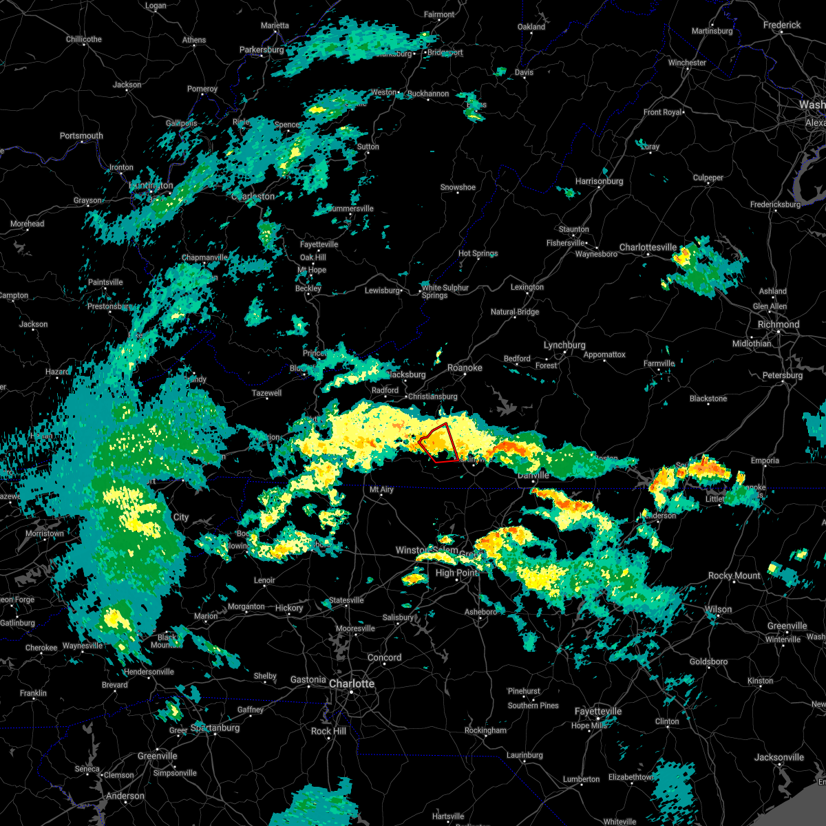 At 330 pm edt, a shower capable of producing a tornado was located over fairy stone state park, or 8 miles east of woolwine, moving northwest at 35 mph (radar indicated rotation). Hazards include tornado. Flying debris will be dangerous to those caught without shelter. mobile homes will be damaged or destroyed. damage to roofs, windows, and vehicles will occur. tree damage is likely. Locations impacted include, sanville, endicott, philpott dam, fairy stone state park, and charity. At 330 pm edt, a shower capable of producing a tornado was located over fairy stone state park, or 8 miles east of woolwine, moving northwest at 35 mph (radar indicated rotation). Hazards include tornado. Flying debris will be dangerous to those caught without shelter. mobile homes will be damaged or destroyed. damage to roofs, windows, and vehicles will occur. tree damage is likely. Locations impacted include, sanville, endicott, philpott dam, fairy stone state park, and charity.
|
| 8/17/2021 3:18 PM EDT |
 At 318 pm edt, a severe thunderstorm capable of producing a tornado was located over chatmoss, or near martinsville, moving northwest at 20 mph (radar indicated rotation). Hazards include tornado. Flying debris will be dangerous to those caught without shelter. mobile homes will be damaged or destroyed. damage to roofs, windows, and vehicles will occur. Tree damage is likely. At 318 pm edt, a severe thunderstorm capable of producing a tornado was located over chatmoss, or near martinsville, moving northwest at 20 mph (radar indicated rotation). Hazards include tornado. Flying debris will be dangerous to those caught without shelter. mobile homes will be damaged or destroyed. damage to roofs, windows, and vehicles will occur. Tree damage is likely.
|
| 8/17/2021 3:17 PM EDT |
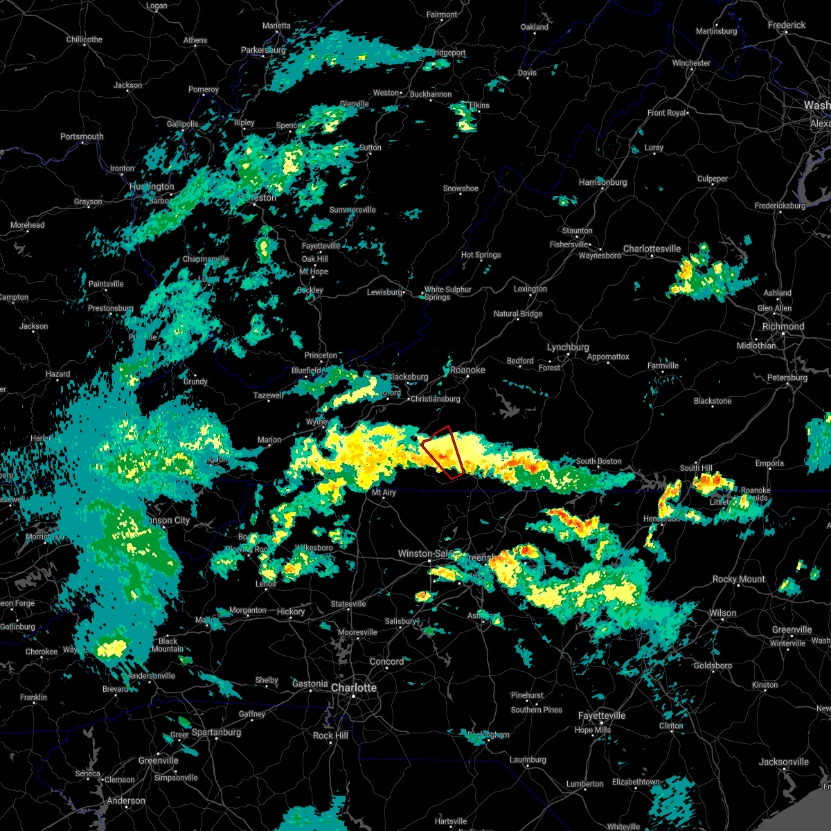 At 316 pm edt, a shower capable of producing a tornado was located over sanville, or near spencer, moving northwest at 35 mph (radar indicated rotation). Hazards include tornado. Flying debris will be dangerous to those caught without shelter. mobile homes will be damaged or destroyed. damage to roofs, windows, and vehicles will occur. Tree damage is likely. At 316 pm edt, a shower capable of producing a tornado was located over sanville, or near spencer, moving northwest at 35 mph (radar indicated rotation). Hazards include tornado. Flying debris will be dangerous to those caught without shelter. mobile homes will be damaged or destroyed. damage to roofs, windows, and vehicles will occur. Tree damage is likely.
|
| 8/16/2021 6:57 PM EDT | Thunderstorm winds blew down one tree near the intersection of cassell drive and morning side driv in henry county VA, 6.2 miles NE of Bassett, VA |
| 8/16/2021 6:49 PM EDT | Thunderstorm winds blew down one tree on route 220 blocking one of the southbound lanes near the intersection of branscome driv in henry county VA, 2.6 miles WNW of Bassett, VA |
| 7/26/2021 4:46 PM EDT |
 At 446 pm edt, severe thunderstorms were located along a line extending from laurel park to near axton to near swansonville, moving east at 20 mph (radar indicated). Hazards include 60 mph wind gusts. Expect damage to roofs, siding, and trees. locations impacted include, martinsville, bassett, axton, leatherwood, villa heights, chatmoss, and collinsville. This includes the following locations the martinsville speedway and martinsville airport. At 446 pm edt, severe thunderstorms were located along a line extending from laurel park to near axton to near swansonville, moving east at 20 mph (radar indicated). Hazards include 60 mph wind gusts. Expect damage to roofs, siding, and trees. locations impacted include, martinsville, bassett, axton, leatherwood, villa heights, chatmoss, and collinsville. This includes the following locations the martinsville speedway and martinsville airport.
|
| 7/26/2021 4:09 PM EDT |
 At 409 pm edt, severe thunderstorms were located along a line extending from bassett to near collinsville to near mountain valley, moving east at 20 mph (radar indicated). Hazards include 60 mph wind gusts. expect damage to roofs, siding, and trees At 409 pm edt, severe thunderstorms were located along a line extending from bassett to near collinsville to near mountain valley, moving east at 20 mph (radar indicated). Hazards include 60 mph wind gusts. expect damage to roofs, siding, and trees
|
| 7/17/2021 8:16 PM EDT |
 At 815 pm edt, severe thunderstorms were located along a line extending from near endicott to near siloam, moving east at 30 mph (radar indicated). Hazards include 60 mph wind gusts. Expect damage to roofs, siding, and trees. Locations impacted include, walnut cove, danbury, spencer, bassett, sandy ridge, king, and pine hall. At 815 pm edt, severe thunderstorms were located along a line extending from near endicott to near siloam, moving east at 30 mph (radar indicated). Hazards include 60 mph wind gusts. Expect damage to roofs, siding, and trees. Locations impacted include, walnut cove, danbury, spencer, bassett, sandy ridge, king, and pine hall.
|
| 7/17/2021 8:14 PM EDT |
 At 814 pm edt, severe thunderstorms were located along a line extending from near fieldale to near ayersville, moving east at 30 mph (radar indicated). Hazards include 60 mph wind gusts. expect damage to roofs, siding, and trees At 814 pm edt, severe thunderstorms were located along a line extending from near fieldale to near ayersville, moving east at 30 mph (radar indicated). Hazards include 60 mph wind gusts. expect damage to roofs, siding, and trees
|
| 7/17/2021 8:02 PM EDT |
 At 802 pm edt, severe thunderstorms were located along a line extending from near rocky knob summit to boonville, moving east at 30 mph (radar indicated). Hazards include 60 mph wind gusts. Expect damage to roofs, siding, and trees. Locations impacted include, mount airy, fairview, flat rock, yadkinville, pilot mountain, walnut cove, and stuart. At 802 pm edt, severe thunderstorms were located along a line extending from near rocky knob summit to boonville, moving east at 30 mph (radar indicated). Hazards include 60 mph wind gusts. Expect damage to roofs, siding, and trees. Locations impacted include, mount airy, fairview, flat rock, yadkinville, pilot mountain, walnut cove, and stuart.
|
| 7/17/2021 7:44 PM EDT |
 At 744 pm edt, severe thunderstorms were located along a line extending from near mabry mill to near swancreek, moving east at 25 mph (radar indicated). Hazards include 60 mph wind gusts. expect damage to roofs, siding, and trees At 744 pm edt, severe thunderstorms were located along a line extending from near mabry mill to near swancreek, moving east at 25 mph (radar indicated). Hazards include 60 mph wind gusts. expect damage to roofs, siding, and trees
|
| 7/17/2021 2:53 PM EDT |
 At 253 pm edt, a severe thunderstorm was located over collinsville, or near martinsville, moving northeast at 15 mph (radar indicated). Hazards include 60 mph wind gusts. expect damage to roofs, siding, and trees At 253 pm edt, a severe thunderstorm was located over collinsville, or near martinsville, moving northeast at 15 mph (radar indicated). Hazards include 60 mph wind gusts. expect damage to roofs, siding, and trees
|
| 6/13/2021 9:48 PM EDT |
 At 946 pm edt, severe thunderstorms were located along a line extending from bassett to stuart to near laurel fork, moving south at 40 mph (radar indicated). Hazards include 70 mph wind gusts. Expect considerable tree damage. damage is likely to mobile homes, roofs, and outbuildings. locations impacted include, martinsville, stuart, axton, ararat, spencer, bassett, and woolwine. This includes the following locations the martinsville speedway and martinsville airport. At 946 pm edt, severe thunderstorms were located along a line extending from bassett to stuart to near laurel fork, moving south at 40 mph (radar indicated). Hazards include 70 mph wind gusts. Expect considerable tree damage. damage is likely to mobile homes, roofs, and outbuildings. locations impacted include, martinsville, stuart, axton, ararat, spencer, bassett, and woolwine. This includes the following locations the martinsville speedway and martinsville airport.
|
| 6/13/2021 8:57 PM EDT |
 At 855 pm edt, severe thunderstorms were located along a line extending from near copper hill to dublin, moving south at 40 mph (radar indicated). Hazards include 60 mph wind gusts. expect damage to trees and powerlines At 855 pm edt, severe thunderstorms were located along a line extending from near copper hill to dublin, moving south at 40 mph (radar indicated). Hazards include 60 mph wind gusts. expect damage to trees and powerlines
|
| 3/27/2021 3:24 PM EDT |
 At 323 pm edt, severe thunderstorms were located along a line extending from roanoke mountain to stanleytown to germanton, moving east at 55 mph (radar indicated). Hazards include 60 mph wind gusts. Expect damage to roofs, siding, and trees. locations impacted include, eden, martinsville, rocky mount, mayodan, madison, walnut cove, and stoneville. This includes the following locations the martinsville speedway and martinsville airport. At 323 pm edt, severe thunderstorms were located along a line extending from roanoke mountain to stanleytown to germanton, moving east at 55 mph (radar indicated). Hazards include 60 mph wind gusts. Expect damage to roofs, siding, and trees. locations impacted include, eden, martinsville, rocky mount, mayodan, madison, walnut cove, and stoneville. This includes the following locations the martinsville speedway and martinsville airport.
|
| 3/27/2021 3:06 PM EDT |
 At 305 pm edt, severe thunderstorms were located along a line extending from terrys fork to near stuart to near courtney, moving east at 50 mph (radar indicated). Hazards include 60 mph wind gusts. Expect damage to roofs, siding, and trees. locations impacted include, christiansburg, eden, martinsville, mount airy, rocky mount, elkin, and fairview. This includes the following locations the martinsville speedway and martinsville airport. At 305 pm edt, severe thunderstorms were located along a line extending from terrys fork to near stuart to near courtney, moving east at 50 mph (radar indicated). Hazards include 60 mph wind gusts. Expect damage to roofs, siding, and trees. locations impacted include, christiansburg, eden, martinsville, mount airy, rocky mount, elkin, and fairview. This includes the following locations the martinsville speedway and martinsville airport.
|
| 3/27/2021 2:56 PM EDT |
 At 256 pm edt, severe thunderstorms were located along a line extending from near pilot to ararat to near buck shoals, moving east at 50 mph (radar indicated). Hazards include 60 mph wind gusts. expect damage to roofs, siding, and trees At 256 pm edt, severe thunderstorms were located along a line extending from near pilot to ararat to near buck shoals, moving east at 50 mph (radar indicated). Hazards include 60 mph wind gusts. expect damage to roofs, siding, and trees
|
| 10/29/2020 11:03 AM EDT |
 At 1102 am edt, a severe thunderstorm was located over sandy river, or near axton, moving northeast at 45 mph. this is a very dangerous storm (emergency management). Hazards include 80 mph wind gusts. Flying debris will be dangerous to those caught without shelter. mobile homes will be heavily damaged. expect considerable damage to roofs, windows, and vehicles. extensive tree damage and power outages are likely. locations impacted include, eden, martinsville, mayodan, madison, chatham, gretna, and stoneville. This includes the following locations the martinsville speedway and martinsville airport. At 1102 am edt, a severe thunderstorm was located over sandy river, or near axton, moving northeast at 45 mph. this is a very dangerous storm (emergency management). Hazards include 80 mph wind gusts. Flying debris will be dangerous to those caught without shelter. mobile homes will be heavily damaged. expect considerable damage to roofs, windows, and vehicles. extensive tree damage and power outages are likely. locations impacted include, eden, martinsville, mayodan, madison, chatham, gretna, and stoneville. This includes the following locations the martinsville speedway and martinsville airport.
|
| 10/29/2020 10:36 AM EDT |
 At 1033 am edt, a severe thunderstorm was located over horse pasture, or over spencer, moving northeast at 35 mph. this is a very dangerous storm (radar indicated). Hazards include 80 mph wind gusts. Flying debris will be dangerous to those caught without shelter. mobile homes will be heavily damaged. expect considerable damage to roofs, windows, and vehicles. extensive tree damage and power outages are likely. locations impacted include, eden, martinsville, rocky mount, mayodan, madison, walnut cove, and stuart. This includes the following locations the martinsville speedway and martinsville airport. At 1033 am edt, a severe thunderstorm was located over horse pasture, or over spencer, moving northeast at 35 mph. this is a very dangerous storm (radar indicated). Hazards include 80 mph wind gusts. Flying debris will be dangerous to those caught without shelter. mobile homes will be heavily damaged. expect considerable damage to roofs, windows, and vehicles. extensive tree damage and power outages are likely. locations impacted include, eden, martinsville, rocky mount, mayodan, madison, walnut cove, and stuart. This includes the following locations the martinsville speedway and martinsville airport.
|
| 10/29/2020 9:50 AM EDT |
 At 947 am edt, a severe thunderstorm was located near pilot mountain, moving northeast at 55 mph. this is a very dangerous storm (radar indicated). Hazards include 80 mph wind gusts. Flying debris will be dangerous to those caught without shelter. mobile homes will be heavily damaged. expect considerable damage to roofs, windows, and vehicles. Extensive tree damage and power outages are likely. At 947 am edt, a severe thunderstorm was located near pilot mountain, moving northeast at 55 mph. this is a very dangerous storm (radar indicated). Hazards include 80 mph wind gusts. Flying debris will be dangerous to those caught without shelter. mobile homes will be heavily damaged. expect considerable damage to roofs, windows, and vehicles. Extensive tree damage and power outages are likely.
|
| 8/3/2020 2:07 PM EDT |
 The severe thunderstorm warning for northeastern floyd, northwestern pittsylvania, southwestern bedford, henry, franklin and eastern patrick counties and the city of martinsville will expire at 215 pm edt, the storms which prompted the warning have weakened below severe limits, and no longer pose an immediate threat to life or property. therefore, the warning will be allowed to expire. however gusty winds and heavy rain are still possible with these thunderstorms. when it is safe to do so, please send your reports of hail of any size, as well as reports of any wind damage, including downed trees or large limbs, to the national weather service by calling toll free at 1, 8 6 6, 2 1 5, 4 3 2 4. reports and pictures can also be shared on the national weather service blacksburg facebook page and on twitter. The severe thunderstorm warning for northeastern floyd, northwestern pittsylvania, southwestern bedford, henry, franklin and eastern patrick counties and the city of martinsville will expire at 215 pm edt, the storms which prompted the warning have weakened below severe limits, and no longer pose an immediate threat to life or property. therefore, the warning will be allowed to expire. however gusty winds and heavy rain are still possible with these thunderstorms. when it is safe to do so, please send your reports of hail of any size, as well as reports of any wind damage, including downed trees or large limbs, to the national weather service by calling toll free at 1, 8 6 6, 2 1 5, 4 3 2 4. reports and pictures can also be shared on the national weather service blacksburg facebook page and on twitter.
|
| 8/3/2020 2:02 PM EDT |
 At 201 pm edt, severe thunderstorms were located along a line extending from near sago to near patrick springs, moving north at 30 mph (radar indicated). Hazards include 60 mph wind gusts. Expect damage to roofs, siding, and trees. Locations impacted include, martinsville, rocky mount, floyd, boones mill, ferrum, moneta, and penhook. At 201 pm edt, severe thunderstorms were located along a line extending from near sago to near patrick springs, moving north at 30 mph (radar indicated). Hazards include 60 mph wind gusts. Expect damage to roofs, siding, and trees. Locations impacted include, martinsville, rocky mount, floyd, boones mill, ferrum, moneta, and penhook.
|
| 8/3/2020 1:46 PM EDT |
 At 146 pm edt, severe thunderstorms were located along a line extending from near swansonville to critz, moving north at 30 mph (radar indicated). Hazards include 60 mph wind gusts. Expect damage to roofs, siding, and trees. locations impacted include, martinsville, rocky mount, stuart, floyd, boones mill, ferrum, and francisco. This includes the following locations the martinsville speedway and martinsville airport. At 146 pm edt, severe thunderstorms were located along a line extending from near swansonville to critz, moving north at 30 mph (radar indicated). Hazards include 60 mph wind gusts. Expect damage to roofs, siding, and trees. locations impacted include, martinsville, rocky mount, stuart, floyd, boones mill, ferrum, and francisco. This includes the following locations the martinsville speedway and martinsville airport.
|
| 8/3/2020 1:37 PM EDT |
 At 137 pm edt, severe thunderstorms were located along a line extending from near swansonville to near penns store, moving north at 30 mph (radar indicated). Hazards include 60 mph wind gusts. Expect damage to roofs, siding, and trees. locations impacted include, martinsville, rocky mount, stuart, floyd, boones mill, danbury, and ferrum. This includes the following locations the martinsville speedway and martinsville airport. At 137 pm edt, severe thunderstorms were located along a line extending from near swansonville to near penns store, moving north at 30 mph (radar indicated). Hazards include 60 mph wind gusts. Expect damage to roofs, siding, and trees. locations impacted include, martinsville, rocky mount, stuart, floyd, boones mill, danbury, and ferrum. This includes the following locations the martinsville speedway and martinsville airport.
|
| 8/3/2020 1:18 PM EDT |
 At 117 pm edt, severe thunderstorms were located along a line extending from near mayfield to near prestonville, moving north at 30 mph (radar indicated). Hazards include 60 mph wind gusts. expect damage to roofs, siding, and trees At 117 pm edt, severe thunderstorms were located along a line extending from near mayfield to near prestonville, moving north at 30 mph (radar indicated). Hazards include 60 mph wind gusts. expect damage to roofs, siding, and trees
|
| 8/2/2020 5:00 PM EDT | 3 trees down down on or near pocahontas trail. one on a power lin in henry county VA, 0.8 miles WNW of Bassett, VA |
| 7/28/2020 2:00 PM EDT | Two trees down on blackberry rd in bassett. one on a phone pol in henry county VA, 1.2 miles NNE of Bassett, VA |
| 7/24/2020 7:40 PM EDT |
 At 739 pm edt, severe thunderstorms were located along a line extending from bassett to leatherwood, moving southeast at 10 mph (radar indicated). Hazards include 60 mph wind gusts and quarter size hail. Hail damage to vehicles is expected. Expect wind damage to roofs, siding, and trees. At 739 pm edt, severe thunderstorms were located along a line extending from bassett to leatherwood, moving southeast at 10 mph (radar indicated). Hazards include 60 mph wind gusts and quarter size hail. Hail damage to vehicles is expected. Expect wind damage to roofs, siding, and trees.
|
| 7/24/2020 5:39 PM EDT |
 At 538 pm edt, a severe thunderstorm was located over collinsville, or just northwest of martinsville, moving southeast at 15 mph (radar indicated). Hazards include 60 mph wind gusts and quarter size hail. Hail damage to vehicles is expected. Expect wind damage to roofs, siding, and trees. At 538 pm edt, a severe thunderstorm was located over collinsville, or just northwest of martinsville, moving southeast at 15 mph (radar indicated). Hazards include 60 mph wind gusts and quarter size hail. Hail damage to vehicles is expected. Expect wind damage to roofs, siding, and trees.
|
| 7/23/2020 3:49 PM EDT |
 At 347 pm edt, a severe thunderstorm was located over villa heights, or over martinsville with another severe thunderstorm over sontag in southeast franklin county, moving northeast at 15 mph (radar indicated). Hazards include 60 mph wind gusts and quarter size hail. Hail damage to vehicles is expected. expect wind damage to roofs, siding, and trees. locations impacted include, martinsville, rocky mount, axton, penhook, spencer, bassett, and sydnorsville. This includes the following locations the martinsville speedway and martinsville airport. At 347 pm edt, a severe thunderstorm was located over villa heights, or over martinsville with another severe thunderstorm over sontag in southeast franklin county, moving northeast at 15 mph (radar indicated). Hazards include 60 mph wind gusts and quarter size hail. Hail damage to vehicles is expected. expect wind damage to roofs, siding, and trees. locations impacted include, martinsville, rocky mount, axton, penhook, spencer, bassett, and sydnorsville. This includes the following locations the martinsville speedway and martinsville airport.
|
| 7/23/2020 3:36 PM EDT |
 At 336 pm edt, a severe thunderstorm was located over spencer, moving northeast at 15 mph (radar indicated). Hazards include 60 mph wind gusts and quarter size hail. Hail damage to vehicles is expected. Expect wind damage to roofs, siding, and trees. At 336 pm edt, a severe thunderstorm was located over spencer, moving northeast at 15 mph (radar indicated). Hazards include 60 mph wind gusts and quarter size hail. Hail damage to vehicles is expected. Expect wind damage to roofs, siding, and trees.
|
| 7/23/2020 3:30 PM EDT | The henry county 911 center reported a tree was blown down by thunderstorm winds across pine valley drive near the intersection with bassett heights roa in henry county VA, 0.8 miles WNW of Bassett, VA |
| 7/19/2020 6:27 PM EDT |
 At 626 pm edt, a severe thunderstorm was located over bassett, moving east at 20 mph (radar indicated). Hazards include 60 mph wind gusts and quarter size hail. Hail damage to vehicles is expected. Expect wind damage to roofs, siding, and trees. At 626 pm edt, a severe thunderstorm was located over bassett, moving east at 20 mph (radar indicated). Hazards include 60 mph wind gusts and quarter size hail. Hail damage to vehicles is expected. Expect wind damage to roofs, siding, and trees.
|
| 7/19/2020 6:18 PM EDT | Tree down... blocking both lanes... at intersection of willie craig road and mount hermon church road. time estimated from rada in henry county VA, 2.7 miles E of Bassett, VA |
| 7/17/2020 4:30 PM EDT |
 At 429 pm edt, a severe thunderstorm was located over snow creek, or near sydnorsville, moving southeast at 15 mph (radar indicated). Hazards include 60 mph wind gusts and quarter size hail. Hail damage to vehicles is expected. Expect wind damage to roofs, siding, and trees. At 429 pm edt, a severe thunderstorm was located over snow creek, or near sydnorsville, moving southeast at 15 mph (radar indicated). Hazards include 60 mph wind gusts and quarter size hail. Hail damage to vehicles is expected. Expect wind damage to roofs, siding, and trees.
|
| 6/21/2020 4:36 PM EDT | Tree down blocking both lanes of bassett heights road near its intersection with pine valley road. time estimated from rada in henry county VA, 0.8 miles WNW of Bassett, VA |
| 6/21/2020 4:35 PM EDT | Tree down across road. time estimated from rada in henry county VA, 1.1 miles N of Bassett, VA |
| 6/21/2020 4:31 PM EDT | Tree down. time estimated from rada in henry county VA, 1.5 miles NE of Bassett, VA |
| 6/21/2020 4:04 PM EDT | Tree down blocking the road. time estimated from rada in patrick county VA, 7.5 miles NE of Bassett, VA |
| 5/24/2020 7:11 PM EDT |
 At 710 pm edt, severe thunderstorms were located along a line extending from stanleytown to price, moving northeast at 5 mph (radar indicated). Hazards include 60 mph wind gusts and half dollar size hail. Hail damage to vehicles is expected. Expect wind damage to roofs, siding, and trees. At 710 pm edt, severe thunderstorms were located along a line extending from stanleytown to price, moving northeast at 5 mph (radar indicated). Hazards include 60 mph wind gusts and half dollar size hail. Hail damage to vehicles is expected. Expect wind damage to roofs, siding, and trees.
|
| 5/24/2020 6:42 PM EDT |
 At 642 pm edt, a severe thunderstorm was located over fieldale, or near bassett, moving southeast at 20 mph (radar indicated). Hazards include 60 mph wind gusts and half dollar size hail. Hail damage to vehicles is expected. expect wind damage to roofs, siding, and trees. Locations impacted include, bassett, fieldale, stanleytown, collinsville, and oak level. At 642 pm edt, a severe thunderstorm was located over fieldale, or near bassett, moving southeast at 20 mph (radar indicated). Hazards include 60 mph wind gusts and half dollar size hail. Hail damage to vehicles is expected. expect wind damage to roofs, siding, and trees. Locations impacted include, bassett, fieldale, stanleytown, collinsville, and oak level.
|
| 5/24/2020 6:38 PM EDT | Tree and power lines down... completely blocking sunnybrook circl in henry county VA, 5 miles ENE of Bassett, VA |
| 5/24/2020 6:31 PM EDT |
 At 631 pm edt, a severe thunderstorm was located over philpott dam, or over bassett, moving southeast at 10 mph (radar indicated). Hazards include 60 mph wind gusts and half dollar size hail. Hail damage to vehicles is expected. Expect wind damage to roofs, siding, and trees. At 631 pm edt, a severe thunderstorm was located over philpott dam, or over bassett, moving southeast at 10 mph (radar indicated). Hazards include 60 mph wind gusts and half dollar size hail. Hail damage to vehicles is expected. Expect wind damage to roofs, siding, and trees.
|
| 4/13/2020 5:15 AM EDT |
 At 514 am edt, severe thunderstorms were located along a line extending from leesville to near pine hall, moving northeast at 35 mph (radar indicated). Hazards include 60 mph wind gusts. Expect damage to roofs, siding, and trees. locations impacted include, eden, martinsville, altavista, wentworth, mayodan, madison, and walnut cove. this includes the following locations the martinsville speedway and martinsville airport. A tornado watch remains in effect until noon edt for north central north carolina, and central and south central virginia. At 514 am edt, severe thunderstorms were located along a line extending from leesville to near pine hall, moving northeast at 35 mph (radar indicated). Hazards include 60 mph wind gusts. Expect damage to roofs, siding, and trees. locations impacted include, eden, martinsville, altavista, wentworth, mayodan, madison, and walnut cove. this includes the following locations the martinsville speedway and martinsville airport. A tornado watch remains in effect until noon edt for north central north carolina, and central and south central virginia.
|
| 4/13/2020 5:07 AM EDT | Tree down at intersection of virginia avenue and oak leve roa in henry county VA, 4.4 miles SSW of Bassett, VA |
| 4/13/2020 4:46 AM EDT |
 At 445 am edt, severe thunderstorms were located along a line extending from near penhook to near winston-salem, moving northeast at 35 mph (radar indicated). Hazards include 60 mph wind gusts. Expect damage to roofs, siding, and trees. locations impacted include, eden, martinsville, altavista, wentworth, mayodan, madison, and walnut cove. This includes the following locations the martinsville speedway and martinsville airport. At 445 am edt, severe thunderstorms were located along a line extending from near penhook to near winston-salem, moving northeast at 35 mph (radar indicated). Hazards include 60 mph wind gusts. Expect damage to roofs, siding, and trees. locations impacted include, eden, martinsville, altavista, wentworth, mayodan, madison, and walnut cove. This includes the following locations the martinsville speedway and martinsville airport.
|
| 4/13/2020 4:35 AM EDT |
 At 435 am edt, severe thunderstorms were located along a line extending from near sontag to near clemmons, moving northeast at 35 mph (radar indicated). Hazards include 60 mph wind gusts. expect damage to roofs, siding, and trees At 435 am edt, severe thunderstorms were located along a line extending from near sontag to near clemmons, moving northeast at 35 mph (radar indicated). Hazards include 60 mph wind gusts. expect damage to roofs, siding, and trees
|
| 4/9/2020 5:07 AM EDT |
 At 506 am edt, severe thunderstorms were located along a line extending from near axton to aiken summit to near price, moving east at 35 mph (radar indicated). Hazards include 60 mph wind gusts. Expect damage to roofs, siding, and trees. locations impacted include, martinsville, spencer, bassett, axton, leatherwood, villa heights, and chatmoss. This includes the following locations the martinsville speedway and martinsville airport. At 506 am edt, severe thunderstorms were located along a line extending from near axton to aiken summit to near price, moving east at 35 mph (radar indicated). Hazards include 60 mph wind gusts. Expect damage to roofs, siding, and trees. locations impacted include, martinsville, spencer, bassett, axton, leatherwood, villa heights, and chatmoss. This includes the following locations the martinsville speedway and martinsville airport.
|
| 4/9/2020 4:45 AM EDT |
 At 444 am edt, severe thunderstorms were located along a line extending from fieldale to near horse pasture to spencer, moving east at 35 mph (radar indicated). Hazards include 60 mph wind gusts. expect damage to roofs, siding, and trees At 444 am edt, severe thunderstorms were located along a line extending from fieldale to near horse pasture to spencer, moving east at 35 mph (radar indicated). Hazards include 60 mph wind gusts. expect damage to roofs, siding, and trees
|
| 4/8/2020 5:50 PM EDT | About a half dozen trees and one power line down in bassett area. one tree fell on mobile home. no one inside. time estimated from rada in henry county VA, 0.3 miles SSW of Bassett, VA |
| 4/8/2020 5:45 PM EDT |
 At 545 pm edt, severe thunderstorms were located along a line extending from near sydnorsville to oak level to near sanville, moving southeast at 50 mph (radar indicated). Hazards include 60 mph wind gusts and quarter size hail. Hail damage to vehicles is expected. expect wind damage to roofs, siding, and trees. locations impacted include, martinsville, spencer, bassett, sydnorsville, snow creek, leatherwood, and villa heights. This includes the following locations the martinsville speedway and martinsville airport. At 545 pm edt, severe thunderstorms were located along a line extending from near sydnorsville to oak level to near sanville, moving southeast at 50 mph (radar indicated). Hazards include 60 mph wind gusts and quarter size hail. Hail damage to vehicles is expected. expect wind damage to roofs, siding, and trees. locations impacted include, martinsville, spencer, bassett, sydnorsville, snow creek, leatherwood, and villa heights. This includes the following locations the martinsville speedway and martinsville airport.
|
| 4/8/2020 5:28 PM EDT |
 At 528 pm edt, severe thunderstorms were located along a line extending from near ferrum to near charity, moving southeast at 50 mph (radar indicated). Hazards include 60 mph wind gusts and half dollar size hail. Hail damage to vehicles is expected. Expect wind damage to roofs, siding, and trees. At 528 pm edt, severe thunderstorms were located along a line extending from near ferrum to near charity, moving southeast at 50 mph (radar indicated). Hazards include 60 mph wind gusts and half dollar size hail. Hail damage to vehicles is expected. Expect wind damage to roofs, siding, and trees.
|
| 1/11/2020 11:08 PM EST |
 The severe thunderstorm warning for eastern stokes, rockingham, western pittsylvania, southwestern bedford, henry, franklin and southeastern patrick counties and the city of martinsville will expire at 1115 pm est, the storms which prompted the warning have moved out of the area. therefore, the warning will be allowed to expire. however gusty winds are still possible with these thunderstorms. a severe thunderstorm watch remains in effect until 100 am est for north central and northwestern north carolina, and south central, central, southwestern and west central virginia. when it is safe to do so, please send your reports of hail of any size, as well as reports of any wind damage, including downed trees or large limbs, to the national weather service by calling toll free at 1, 8 6 6, 2 1 5, 4 3 2 4. reports and pictures can also be shared on the national weather service blacksburg facebook page and on twitter. The severe thunderstorm warning for eastern stokes, rockingham, western pittsylvania, southwestern bedford, henry, franklin and southeastern patrick counties and the city of martinsville will expire at 1115 pm est, the storms which prompted the warning have moved out of the area. therefore, the warning will be allowed to expire. however gusty winds are still possible with these thunderstorms. a severe thunderstorm watch remains in effect until 100 am est for north central and northwestern north carolina, and south central, central, southwestern and west central virginia. when it is safe to do so, please send your reports of hail of any size, as well as reports of any wind damage, including downed trees or large limbs, to the national weather service by calling toll free at 1, 8 6 6, 2 1 5, 4 3 2 4. reports and pictures can also be shared on the national weather service blacksburg facebook page and on twitter.
|
| 1/11/2020 10:40 PM EST |
 At 1039 pm est, severe thunderstorms were located along a line extending from near arcadia to near bethany, moving east at 45 mph (radar indicated). Hazards include 60 mph wind gusts. expect damage to roofs, siding, and trees At 1039 pm est, severe thunderstorms were located along a line extending from near arcadia to near bethany, moving east at 45 mph (radar indicated). Hazards include 60 mph wind gusts. expect damage to roofs, siding, and trees
|
| 1/11/2020 9:43 PM EST |
 At 942 pm est, severe thunderstorms were located along a line extending from near huffman to near courtney, moving northeast at 50 mph (radar indicated). Hazards include 70 mph wind gusts. Expect considerable tree damage. Damage is likely to mobile homes, roofs, and outbuildings. At 942 pm est, severe thunderstorms were located along a line extending from near huffman to near courtney, moving northeast at 50 mph (radar indicated). Hazards include 70 mph wind gusts. Expect considerable tree damage. Damage is likely to mobile homes, roofs, and outbuildings.
|
| 8/22/2019 3:25 PM EDT |
 The severe thunderstorm warning for henry and southeastern franklin counties and the city of martinsville will expire at 330 pm edt, the storm which prompted the warning has weakened below severe limits, and no longer poses an immediate threat to life or property. therefore, the warning will be allowed to expire. however gusty winds and heavy rain are still possible with this thunderstorm. when it is safe to do so, please send your reports of hail of any size, as well as reports of any wind damage, including downed trees or large limbs, to the national weather service by calling toll free at 1, 8 6 6, 2 1 5, 4 3 2 4. reports and pictures can also be shared on the national weather service blacksburg facebook page and on twitter. The severe thunderstorm warning for henry and southeastern franklin counties and the city of martinsville will expire at 330 pm edt, the storm which prompted the warning has weakened below severe limits, and no longer poses an immediate threat to life or property. therefore, the warning will be allowed to expire. however gusty winds and heavy rain are still possible with this thunderstorm. when it is safe to do so, please send your reports of hail of any size, as well as reports of any wind damage, including downed trees or large limbs, to the national weather service by calling toll free at 1, 8 6 6, 2 1 5, 4 3 2 4. reports and pictures can also be shared on the national weather service blacksburg facebook page and on twitter.
|
| 8/22/2019 3:11 PM EDT |
 At 310 pm edt, a severe thunderstorm was located over chatmoss, moving southeast at 10 mph (radar indicated). Hazards include 60 mph wind gusts and quarter size hail. Hail damage to vehicles is expected. expect wind damage to roofs, siding, and trees. locations impacted include, martinsville, spencer, bassett, sydnorsville, and axton. This includes the following locations the martinsville speedway and martinsville airport. At 310 pm edt, a severe thunderstorm was located over chatmoss, moving southeast at 10 mph (radar indicated). Hazards include 60 mph wind gusts and quarter size hail. Hail damage to vehicles is expected. expect wind damage to roofs, siding, and trees. locations impacted include, martinsville, spencer, bassett, sydnorsville, and axton. This includes the following locations the martinsville speedway and martinsville airport.
|
| 8/22/2019 2:54 PM EDT |
 The national weather service in blacksburg has issued a * severe thunderstorm warning for. the city of martinsville in south central virginia. bedford county in south central virginia. henry county in south central virginia. The city of lynchburg in central virginia. The national weather service in blacksburg has issued a * severe thunderstorm warning for. the city of martinsville in south central virginia. bedford county in south central virginia. henry county in south central virginia. The city of lynchburg in central virginia.
|
| 8/22/2019 2:25 PM EDT | Tree down at the intersection of raceway dr. and rockwood park rd. timing estimated by rada in henry county VA, 5 miles SW of Bassett, VA |
| 8/22/2019 2:24 PM EDT |
 At 224 pm edt, a severe thunderstorm was located over oak level, moving northeast at 10 mph (radar indicated). Hazards include 60 mph wind gusts and quarter size hail. Hail damage to vehicles is expected. Expect wind damage to roofs, siding, and trees. At 224 pm edt, a severe thunderstorm was located over oak level, moving northeast at 10 mph (radar indicated). Hazards include 60 mph wind gusts and quarter size hail. Hail damage to vehicles is expected. Expect wind damage to roofs, siding, and trees.
|
| 8/22/2019 2:23 PM EDT | Tree down along pawnee lan in henry county VA, 5 miles SW of Bassett, VA |
| 8/13/2019 2:54 PM EDT |
 The national weather service in blacksburg has issued a * severe thunderstorm warning for. northeastern surry county in northwestern north carolina. stokes county in north central north carolina. northern rockingham county in north central north carolina. The city of danville in south central virginia. The national weather service in blacksburg has issued a * severe thunderstorm warning for. northeastern surry county in northwestern north carolina. stokes county in north central north carolina. northern rockingham county in north central north carolina. The city of danville in south central virginia.
|
| 8/13/2019 2:54 PM EDT |
 At 253 pm edt, severe thunderstorms were located along a line extending from dry fork to white plains, moving east at 25 mph (radar indicated). Hazards include 60 mph wind gusts and quarter size hail. Hail damage to vehicles is expected. Expect wind damage to roofs, siding, and trees. At 253 pm edt, severe thunderstorms were located along a line extending from dry fork to white plains, moving east at 25 mph (radar indicated). Hazards include 60 mph wind gusts and quarter size hail. Hail damage to vehicles is expected. Expect wind damage to roofs, siding, and trees.
|
| 8/13/2019 2:10 PM EDT | Tree down on blue ridge yacht club rd. time estimated by rada in henry county VA, 3.8 miles E of Bassett, VA |
| 8/13/2019 2:07 PM EDT |
 At 207 pm edt, severe thunderstorms were located along a line extending from sydnorsville to philpott dam to near buffalo ridge, moving east at 25 mph (radar indicated). Hazards include 60 mph wind gusts and quarter size hail. Hail damage to vehicles is expected. Expect wind damage to roofs, siding, and trees. At 207 pm edt, severe thunderstorms were located along a line extending from sydnorsville to philpott dam to near buffalo ridge, moving east at 25 mph (radar indicated). Hazards include 60 mph wind gusts and quarter size hail. Hail damage to vehicles is expected. Expect wind damage to roofs, siding, and trees.
|
| 7/22/2019 3:38 PM EDT |
 At 337 pm edt, a severe thunderstorm was located near sanville, moving east at 15 mph (radar indicated). Hazards include 60 mph wind gusts and quarter size hail. Hail damage to vehicles is expected. expect wind damage to roofs, siding, and trees. Locations impacted include, bassett, sanville, fieldale, horse pasture, and philpott dam. At 337 pm edt, a severe thunderstorm was located near sanville, moving east at 15 mph (radar indicated). Hazards include 60 mph wind gusts and quarter size hail. Hail damage to vehicles is expected. expect wind damage to roofs, siding, and trees. Locations impacted include, bassett, sanville, fieldale, horse pasture, and philpott dam.
|
| 7/22/2019 2:58 PM EDT |
 At 257 pm edt, a severe thunderstorm was located near buffalo ridge, moving east at 15 mph (radar indicated). Hazards include 60 mph wind gusts and quarter size hail. Hail damage to vehicles is expected. Expect wind damage to roofs, siding, and trees. At 257 pm edt, a severe thunderstorm was located near buffalo ridge, moving east at 15 mph (radar indicated). Hazards include 60 mph wind gusts and quarter size hail. Hail damage to vehicles is expected. Expect wind damage to roofs, siding, and trees.
|
| 6/30/2019 4:37 PM EDT |
 The severe thunderstorm warning for southwestern henry and southeastern patrick counties will expire at 445 pm edt, the storm which prompted the warning has weakened below severe limits and has exited the warned area. therefore, the warning will be allowed to expire. when it is safe to do so, please send your reports of hail of any size, as well as reports of any wind damage, including downed trees or large limbs, to the national weather service by calling toll free at 1, 8 6 6, 2 1 5, 4 3 2 4. reports and pictures can also be shared on the national weather service blacksburg facebook page and on twitter. The severe thunderstorm warning for southwestern henry and southeastern patrick counties will expire at 445 pm edt, the storm which prompted the warning has weakened below severe limits and has exited the warned area. therefore, the warning will be allowed to expire. when it is safe to do so, please send your reports of hail of any size, as well as reports of any wind damage, including downed trees or large limbs, to the national weather service by calling toll free at 1, 8 6 6, 2 1 5, 4 3 2 4. reports and pictures can also be shared on the national weather service blacksburg facebook page and on twitter.
|
| 6/30/2019 4:18 PM EDT |
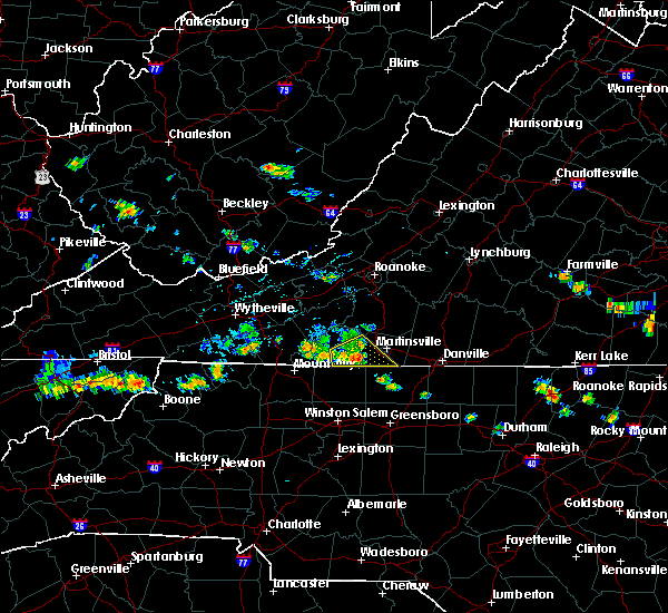 At 417 pm edt, a severe thunderstorm was located near critz, moving southeast at 30 mph (radar indicated). Hazards include 60 mph wind gusts. Expect damage to roofs, siding, and trees. locations impacted include, stuart, spencer, bassett, sanville, and penns store. This includes the following location martinsville airport. At 417 pm edt, a severe thunderstorm was located near critz, moving southeast at 30 mph (radar indicated). Hazards include 60 mph wind gusts. Expect damage to roofs, siding, and trees. locations impacted include, stuart, spencer, bassett, sanville, and penns store. This includes the following location martinsville airport.
|
| 6/30/2019 3:59 PM EDT |
 At 358 pm edt, a severe thunderstorm was located over charity, moving southeast at 25 mph (radar indicated). Hazards include 60 mph wind gusts. Expect damage to roofs, siding, and trees. locations impacted include, stuart, spencer, woolwine, bassett, and critz. This includes the following location martinsville airport. At 358 pm edt, a severe thunderstorm was located over charity, moving southeast at 25 mph (radar indicated). Hazards include 60 mph wind gusts. Expect damage to roofs, siding, and trees. locations impacted include, stuart, spencer, woolwine, bassett, and critz. This includes the following location martinsville airport.
|
| 6/30/2019 3:51 PM EDT |
 At 351 pm edt, a severe thunderstorm was located over charity, moving southeast at 30 mph (radar indicated). Hazards include 60 mph wind gusts. expect damage to roofs, siding, and trees At 351 pm edt, a severe thunderstorm was located over charity, moving southeast at 30 mph (radar indicated). Hazards include 60 mph wind gusts. expect damage to roofs, siding, and trees
|
| 6/17/2019 2:45 PM EDT | Tree down on fairystone park highway and william f stone highway near bassett. time estimate in henry county VA, 2.9 miles NW of Bassett, VA |
| 5/31/2019 7:28 PM EDT | A few small trees damaged and strewn on trent hill rd in bassett.time radar estimate in henry county VA, 1.9 miles ESE of Bassett, VA |
| 5/31/2019 7:19 PM EDT | Corrects previous tstm wnd dmg report from 1 ssw bassett. 3-4 trees and two power lines down in the area around the 4300 block of fairystone parkway near bassett. one t in henry county VA, 0.6 miles NE of Bassett, VA |
| 5/31/2019 7:17 PM EDT |
 The national weather service in blacksburg has issued a * tornado warning for. the city of martinsville in south central virginia. henry county in south central virginia. Until 745 pm edt * at 717 pm edt, a severe thunderstorm capable of producing a tornado. The national weather service in blacksburg has issued a * tornado warning for. the city of martinsville in south central virginia. henry county in south central virginia. Until 745 pm edt * at 717 pm edt, a severe thunderstorm capable of producing a tornado.
|
| 5/31/2019 7:15 PM EDT | 3-4 trees and two power lines down in the area around the 4300 block of fairystone parkway near bassett. one tree was also down on trenthill road... lenoir street. fair in henry county VA, 0.6 miles NE of Bassett, VA |
| 5/31/2019 7:13 PM EDT |
 At 712 pm edt, a severe thunderstorm was located over oak level, moving southeast at 20 mph (radar indicated). Hazards include 60 mph wind gusts and quarter size hail. Hail damage to vehicles is expected. Expect wind damage to roofs, siding, and trees. At 712 pm edt, a severe thunderstorm was located over oak level, moving southeast at 20 mph (radar indicated). Hazards include 60 mph wind gusts and quarter size hail. Hail damage to vehicles is expected. Expect wind damage to roofs, siding, and trees.
|
| 5/29/2019 6:56 PM EDT |
 The severe thunderstorm warning for alleghany and northern surry counties in northwestern north carolina, southern floyd county in southwestern virginia, central pittsylvania county in south central virginia, carroll county in southwestern virginia, henry county in south central virginia, southeastern grayson county in southwestern virginia, southern franklin county in west central virginia and patrick counties in southwestern virginia, the city of martinsville and the city of galax will expire at 700 pm edt, the storms which prompted the warning have moved out of the area. therefore, the warning will be allowed to expire and a new warning has been issued further to the east. a severe thunderstorm watch remains in effect until 900 pm edt for north central north carolina, and south central, central, southwestern and west central virginia. when it is safe to do so, please send your reports of hail of any size, as well as reports of any wind damage, including downed trees or large limbs, to the national weather service by calling toll free at 1, 8 6 6, 2 1 5, 4 3 2 4. reports and pictures can also be shared on the national weather service blacksburg facebook page and on twitter. The severe thunderstorm warning for alleghany and northern surry counties in northwestern north carolina, southern floyd county in southwestern virginia, central pittsylvania county in south central virginia, carroll county in southwestern virginia, henry county in south central virginia, southeastern grayson county in southwestern virginia, southern franklin county in west central virginia and patrick counties in southwestern virginia, the city of martinsville and the city of galax will expire at 700 pm edt, the storms which prompted the warning have moved out of the area. therefore, the warning will be allowed to expire and a new warning has been issued further to the east. a severe thunderstorm watch remains in effect until 900 pm edt for north central north carolina, and south central, central, southwestern and west central virginia. when it is safe to do so, please send your reports of hail of any size, as well as reports of any wind damage, including downed trees or large limbs, to the national weather service by calling toll free at 1, 8 6 6, 2 1 5, 4 3 2 4. reports and pictures can also be shared on the national weather service blacksburg facebook page and on twitter.
|
| 5/29/2019 6:56 PM EDT |
 At 620 pm edt, severe thunderstorms were located along a line extending from near gretna to near woolwine to sparta, moving east at 60 mph (radar indicated). Hazards include 60 mph wind gusts and quarter size hail. Hail damage to vehicles is expected. expect wind damage to roofs, siding, and trees. locations impacted include, martinsville, mount airy, galax, flat rock, and hillsville. This includes the following locations the martinsville speedway and martinsville airport. At 620 pm edt, severe thunderstorms were located along a line extending from near gretna to near woolwine to sparta, moving east at 60 mph (radar indicated). Hazards include 60 mph wind gusts and quarter size hail. Hail damage to vehicles is expected. expect wind damage to roofs, siding, and trees. locations impacted include, martinsville, mount airy, galax, flat rock, and hillsville. This includes the following locations the martinsville speedway and martinsville airport.
|
| 5/29/2019 6:25 PM EDT | Trees down on philpott driv in henry county VA, 1.9 miles ESE of Bassett, VA |
| 5/29/2019 6:21 PM EDT |
 At 620 pm edt, severe thunderstorms were located along a line extending from near gretna to near woolwine to sparta, moving east at 60 mph (radar indicated). Hazards include 60 mph wind gusts and quarter size hail. Hail damage to vehicles is expected. expect wind damage to roofs, siding, and trees. locations impacted include, martinsville, mount airy, galax, flat rock, and hillsville. This includes the following locations the martinsville speedway and martinsville airport. At 620 pm edt, severe thunderstorms were located along a line extending from near gretna to near woolwine to sparta, moving east at 60 mph (radar indicated). Hazards include 60 mph wind gusts and quarter size hail. Hail damage to vehicles is expected. expect wind damage to roofs, siding, and trees. locations impacted include, martinsville, mount airy, galax, flat rock, and hillsville. This includes the following locations the martinsville speedway and martinsville airport.
|
| 5/29/2019 6:00 PM EDT |
 At 600 pm edt, severe thunderstorms were located along a line extending from near copper hill to volney, moving southeast at 55 mph (radar indicated). Hazards include 60 mph wind gusts and quarter size hail. Hail damage to vehicles is expected. Expect wind damage to roofs, siding, and trees. At 600 pm edt, severe thunderstorms were located along a line extending from near copper hill to volney, moving southeast at 55 mph (radar indicated). Hazards include 60 mph wind gusts and quarter size hail. Hail damage to vehicles is expected. Expect wind damage to roofs, siding, and trees.
|
| 5/25/2019 8:09 PM EDT |
 At 808 pm edt, a severe thunderstorm was located over villa heights, moving east at 40 mph (radar indicated). Hazards include 60 mph wind gusts and quarter size hail. Hail damage to vehicles is expected. Expect wind damage to roofs, siding, and trees. At 808 pm edt, a severe thunderstorm was located over villa heights, moving east at 40 mph (radar indicated). Hazards include 60 mph wind gusts and quarter size hail. Hail damage to vehicles is expected. Expect wind damage to roofs, siding, and trees.
|
| 5/4/2019 5:14 PM EDT |
 At 513 pm edt, a severe thunderstorm was located near charity, moving east at 20 mph (radar indicated). Hazards include 60 mph wind gusts and quarter size hail. Hail damage to vehicles is expected. expect wind damage to roofs, siding, and trees. Locations impacted include, bassett, sydnorsville, ferrum, snow creek, and leatherwood. At 513 pm edt, a severe thunderstorm was located near charity, moving east at 20 mph (radar indicated). Hazards include 60 mph wind gusts and quarter size hail. Hail damage to vehicles is expected. expect wind damage to roofs, siding, and trees. Locations impacted include, bassett, sydnorsville, ferrum, snow creek, and leatherwood.
|
| 5/4/2019 5:02 PM EDT |
 At 501 pm edt, a severe thunderstorm was located over charity, moving east at 25 mph (radar indicated). Hazards include 60 mph wind gusts and quarter size hail. Hail damage to vehicles is expected. Expect wind damage to roofs, siding, and trees. At 501 pm edt, a severe thunderstorm was located over charity, moving east at 25 mph (radar indicated). Hazards include 60 mph wind gusts and quarter size hail. Hail damage to vehicles is expected. Expect wind damage to roofs, siding, and trees.
|
| 4/19/2019 3:26 PM EDT |
 The severe thunderstorm warning for western rockingham and henry counties and the city of martinsville will expire at 330 pm edt, the storm which prompted the warning has moved out of the area. therefore, the warning will be allowed to expire. a tornado watch remains in effect until 500 pm edt for north central north carolina, and south central, southwestern and west central virginia. when it is safe to do so, please send your reports of hail of any size, as well as reports of any wind damage, including downed trees or large limbs, to the national weather service by calling toll free at 1, 8 6 6, 2 1 5, 4 3 2 4. reports and pictures can also be shared on the national weather service blacksburg facebook page and on twitter. The severe thunderstorm warning for western rockingham and henry counties and the city of martinsville will expire at 330 pm edt, the storm which prompted the warning has moved out of the area. therefore, the warning will be allowed to expire. a tornado watch remains in effect until 500 pm edt for north central north carolina, and south central, southwestern and west central virginia. when it is safe to do so, please send your reports of hail of any size, as well as reports of any wind damage, including downed trees or large limbs, to the national weather service by calling toll free at 1, 8 6 6, 2 1 5, 4 3 2 4. reports and pictures can also be shared on the national weather service blacksburg facebook page and on twitter.
|
| 4/19/2019 3:21 PM EDT |
 At 321 pm edt, a severe thunderstorm was located over spencer, moving north at 50 mph (radar indicated). Hazards include 60 mph wind gusts. Expect damage to roofs, siding, and trees. locations impacted include, martinsville, mayodan, madison, stoneville, and spencer. this includes the following locations the martinsville speedway and martinsville airport. A tornado watch remains in effect until 500 pm edt for north central north carolina, and south central, southwestern and west central virginia. At 321 pm edt, a severe thunderstorm was located over spencer, moving north at 50 mph (radar indicated). Hazards include 60 mph wind gusts. Expect damage to roofs, siding, and trees. locations impacted include, martinsville, mayodan, madison, stoneville, and spencer. this includes the following locations the martinsville speedway and martinsville airport. A tornado watch remains in effect until 500 pm edt for north central north carolina, and south central, southwestern and west central virginia.
|
| 4/19/2019 3:12 PM EDT |
 At 312 pm edt, a severe thunderstorm was located near sandy ridge, moving northeast at 55 mph (radar indicated). Hazards include 60 mph wind gusts. Expect damage to roofs, siding, and trees. locations impacted include, martinsville, mayodan, madison, stoneville, and spencer. this includes the following locations the martinsville speedway and martinsville airport. A tornado watch remains in effect until 500 pm edt for north central and northwestern north carolina, and south central, southwestern and west central virginia. At 312 pm edt, a severe thunderstorm was located near sandy ridge, moving northeast at 55 mph (radar indicated). Hazards include 60 mph wind gusts. Expect damage to roofs, siding, and trees. locations impacted include, martinsville, mayodan, madison, stoneville, and spencer. this includes the following locations the martinsville speedway and martinsville airport. A tornado watch remains in effect until 500 pm edt for north central and northwestern north carolina, and south central, southwestern and west central virginia.
|
| 4/19/2019 2:37 PM EDT |
 At 237 pm edt, a severe thunderstorm was located near winston-salem, moving north at 50 mph (radar indicated). Hazards include 60 mph wind gusts and quarter size hail. Hail damage to vehicles is expected. Expect wind damage to roofs, siding, and trees. At 237 pm edt, a severe thunderstorm was located near winston-salem, moving north at 50 mph (radar indicated). Hazards include 60 mph wind gusts and quarter size hail. Hail damage to vehicles is expected. Expect wind damage to roofs, siding, and trees.
|
| 4/19/2019 10:19 AM EDT |
 At 1018 am edt, a severe thunderstorm capable of producing a tornado was located over oak level, moving northeast at 40 mph (radar indicated rotation). Hazards include tornado and quarter size hail. Flying debris will be dangerous to those caught without shelter. mobile homes will be damaged or destroyed. damage to roofs, windows, and vehicles will occur. tree damage is likely. Locations impacted include, sydnorsville, oak level, and stanleytown. At 1018 am edt, a severe thunderstorm capable of producing a tornado was located over oak level, moving northeast at 40 mph (radar indicated rotation). Hazards include tornado and quarter size hail. Flying debris will be dangerous to those caught without shelter. mobile homes will be damaged or destroyed. damage to roofs, windows, and vehicles will occur. tree damage is likely. Locations impacted include, sydnorsville, oak level, and stanleytown.
|
| 4/19/2019 10:03 AM EDT |
 At 1003 am edt, a severe thunderstorm capable of producing a tornado was located over sanville, moving northeast at 40 mph (radar indicated rotation). Hazards include tornado and quarter size hail. Flying debris will be dangerous to those caught without shelter. mobile homes will be damaged or destroyed. damage to roofs, windows, and vehicles will occur. Tree damage is likely. At 1003 am edt, a severe thunderstorm capable of producing a tornado was located over sanville, moving northeast at 40 mph (radar indicated rotation). Hazards include tornado and quarter size hail. Flying debris will be dangerous to those caught without shelter. mobile homes will be damaged or destroyed. damage to roofs, windows, and vehicles will occur. Tree damage is likely.
|
| 4/15/2019 12:38 AM EDT |
 The severe thunderstorm warning for stokes, western henry, southwestern franklin and eastern patrick counties will expire at 1245 am edt, the storms which prompted the warning have weakened below severe limits, and no longer pose an immediate threat to life or property. therefore, the warning will be allowed to expire. however gusty winds are still possible with these thunderstorms. a tornado watch remains in effect until 500 am edt for north central and northwestern north carolina, and south central, southwestern and west central virginia. when it is safe to do so, please send your reports of hail of any size, as well as reports of any wind damage, including downed trees or large limbs, to the national weather service by calling toll free at 1, 8 6 6, 2 1 5, 4 3 2 4. reports and pictures can also be shared on the national weather service blacksburg facebook page and on twitter. The severe thunderstorm warning for stokes, western henry, southwestern franklin and eastern patrick counties will expire at 1245 am edt, the storms which prompted the warning have weakened below severe limits, and no longer pose an immediate threat to life or property. therefore, the warning will be allowed to expire. however gusty winds are still possible with these thunderstorms. a tornado watch remains in effect until 500 am edt for north central and northwestern north carolina, and south central, southwestern and west central virginia. when it is safe to do so, please send your reports of hail of any size, as well as reports of any wind damage, including downed trees or large limbs, to the national weather service by calling toll free at 1, 8 6 6, 2 1 5, 4 3 2 4. reports and pictures can also be shared on the national weather service blacksburg facebook page and on twitter.
|
| 4/15/2019 12:25 AM EDT |
 At 1225 am edt, severe thunderstorms were located along a line extending from near ferrum to near clemmons, moving east at 25 mph (radar indicated). Hazards include 60 mph wind gusts. Expect damage to roofs, siding, and trees. locations impacted include, walnut cove, stuart, danbury, ferrum, and spencer. A tornado watch remains in effect until 500 am edt for north central and northwestern north carolina, and south central, southwestern and west central virginia. At 1225 am edt, severe thunderstorms were located along a line extending from near ferrum to near clemmons, moving east at 25 mph (radar indicated). Hazards include 60 mph wind gusts. Expect damage to roofs, siding, and trees. locations impacted include, walnut cove, stuart, danbury, ferrum, and spencer. A tornado watch remains in effect until 500 am edt for north central and northwestern north carolina, and south central, southwestern and west central virginia.
|
| 4/15/2019 12:09 AM EDT |
 At 1208 am edt, severe thunderstorms were located along a line extending from near endicott to near huntsville, moving east at 35 mph (radar indicated). Hazards include 60 mph wind gusts. Expect damage to roofs, siding, and trees. locations impacted include, pilot mountain, walnut cove, stuart, east bend, and danbury. A tornado watch remains in effect until 500 am edt for north central and northwestern north carolina, and south central, southwestern and west central virginia. At 1208 am edt, severe thunderstorms were located along a line extending from near endicott to near huntsville, moving east at 35 mph (radar indicated). Hazards include 60 mph wind gusts. Expect damage to roofs, siding, and trees. locations impacted include, pilot mountain, walnut cove, stuart, east bend, and danbury. A tornado watch remains in effect until 500 am edt for north central and northwestern north carolina, and south central, southwestern and west central virginia.
|
| 4/14/2019 11:39 PM EDT |
 At 1139 pm edt, severe thunderstorms were located along a line extending from near alum ridge to near buck shoals, moving east at 25 mph (radar indicated). Hazards include 60 mph wind gusts. expect damage to roofs, siding, and trees At 1139 pm edt, severe thunderstorms were located along a line extending from near alum ridge to near buck shoals, moving east at 25 mph (radar indicated). Hazards include 60 mph wind gusts. expect damage to roofs, siding, and trees
|
| 4/14/2019 7:57 PM EDT |
 At 756 pm edt, a severe thunderstorm capable of producing a tornado was located over collinsville, moving northeast at 50 mph (radar indicated rotation). Hazards include tornado. Flying debris will be dangerous to those caught without shelter. mobile homes will be damaged or destroyed. damage to roofs, windows, and vehicles will occur. tree damage is likely. Locations impacted include, penhook, bassett, sydnorsville, snow creek, and stanleytown. At 756 pm edt, a severe thunderstorm capable of producing a tornado was located over collinsville, moving northeast at 50 mph (radar indicated rotation). Hazards include tornado. Flying debris will be dangerous to those caught without shelter. mobile homes will be damaged or destroyed. damage to roofs, windows, and vehicles will occur. tree damage is likely. Locations impacted include, penhook, bassett, sydnorsville, snow creek, and stanleytown.
|
| 4/14/2019 7:49 PM EDT |
 At 748 pm edt, a severe thunderstorm capable of producing a tornado was located over fieldale, moving northeast at 50 mph (radar indicated rotation). Hazards include tornado. Flying debris will be dangerous to those caught without shelter. mobile homes will be damaged or destroyed. damage to roofs, windows, and vehicles will occur. Tree damage is likely. At 748 pm edt, a severe thunderstorm capable of producing a tornado was located over fieldale, moving northeast at 50 mph (radar indicated rotation). Hazards include tornado. Flying debris will be dangerous to those caught without shelter. mobile homes will be damaged or destroyed. damage to roofs, windows, and vehicles will occur. Tree damage is likely.
|
| 8/30/2018 1:37 PM EDT |
 At 134 pm edt, an area severe thunderstorms was drifting east at less than 10 mph across portions of eastern patrick county into northwest henry county (radar indicated). Hazards include 60 mph wind gusts. Expect damage to roofs, siding, and trees. Locations impacted include, stuart, spencer, bassett, woolwine, and critz. At 134 pm edt, an area severe thunderstorms was drifting east at less than 10 mph across portions of eastern patrick county into northwest henry county (radar indicated). Hazards include 60 mph wind gusts. Expect damage to roofs, siding, and trees. Locations impacted include, stuart, spencer, bassett, woolwine, and critz.
|
| 8/30/2018 1:16 PM EDT |
 At 116 pm edt, a severe thunderstorm was located near critz, moving east at 10 mph (radar indicated). Hazards include 60 mph wind gusts. expect damage to roofs, siding, and trees At 116 pm edt, a severe thunderstorm was located near critz, moving east at 10 mph (radar indicated). Hazards include 60 mph wind gusts. expect damage to roofs, siding, and trees
|
| 8/12/2018 3:22 PM EDT |
 At 319 pm edt, while radar indicates the storm that intially prompted the warning has weakened below severe levels, additional storms are forming quickly west of martinsville and currently are capable of producing pea size hail. however, the concern remains that these storms may intensify to severe levels with quarter size hail and 60 mph wind gusts possible. therefore, the warning will be allowed to continue (radar indicated). Hazards include 60 mph wind gusts and quarter size hail. Hail damage to vehicles is expected. expect wind damage to roofs, siding, and trees. locations impacted include, martinsville, spencer, callands, bassett, and axton. This includes the following locations the martinsville speedway and martinsville airport. At 319 pm edt, while radar indicates the storm that intially prompted the warning has weakened below severe levels, additional storms are forming quickly west of martinsville and currently are capable of producing pea size hail. however, the concern remains that these storms may intensify to severe levels with quarter size hail and 60 mph wind gusts possible. therefore, the warning will be allowed to continue (radar indicated). Hazards include 60 mph wind gusts and quarter size hail. Hail damage to vehicles is expected. expect wind damage to roofs, siding, and trees. locations impacted include, martinsville, spencer, callands, bassett, and axton. This includes the following locations the martinsville speedway and martinsville airport.
|
| 8/12/2018 2:47 PM EDT |
 At 247 pm edt, a severe thunderstorm was located over fieldale, moving east at 20 mph (radar indicated). Hazards include 60 mph wind gusts and quarter size hail. Hail damage to vehicles is expected. Expect wind damage to roofs, siding, and trees. At 247 pm edt, a severe thunderstorm was located over fieldale, moving east at 20 mph (radar indicated). Hazards include 60 mph wind gusts and quarter size hail. Hail damage to vehicles is expected. Expect wind damage to roofs, siding, and trees.
|
| 8/2/2018 4:56 PM EDT |
 At 456 pm edt, severe thunderstorms were located along a line extending from near figsboro to martinsville, moving northeast at 30 mph (radar indicated). Hazards include 60 mph wind gusts. Expect damage to roofs, siding, and trees. locations impacted include, martinsville, spencer, bassett, axton, and leatherwood. This includes the following locations the martinsville speedway and martinsville airport. At 456 pm edt, severe thunderstorms were located along a line extending from near figsboro to martinsville, moving northeast at 30 mph (radar indicated). Hazards include 60 mph wind gusts. Expect damage to roofs, siding, and trees. locations impacted include, martinsville, spencer, bassett, axton, and leatherwood. This includes the following locations the martinsville speedway and martinsville airport.
|
| 8/2/2018 4:25 PM EDT |
 At 425 pm edt, severe thunderstorms were located along a line extending from sanville to near sandy ridge, moving northeast at 30 mph (radar indicated). Hazards include 60 mph wind gusts. expect damage to roofs, siding, and trees At 425 pm edt, severe thunderstorms were located along a line extending from sanville to near sandy ridge, moving northeast at 30 mph (radar indicated). Hazards include 60 mph wind gusts. expect damage to roofs, siding, and trees
|
| 8/1/2018 6:18 PM EDT |
 At 617 pm edt, severe thunderstorms were located along a line extending from near ferrum to fieldale to near mayodan, moving northeast at 25 mph (radar indicated). Hazards include 60 mph wind gusts. Expect damage to roofs, siding, and trees. locations impacted include, martinsville, rocky mount, axton, penhook, and spencer. This includes the following locations the martinsville speedway and martinsville airport. At 617 pm edt, severe thunderstorms were located along a line extending from near ferrum to fieldale to near mayodan, moving northeast at 25 mph (radar indicated). Hazards include 60 mph wind gusts. Expect damage to roofs, siding, and trees. locations impacted include, martinsville, rocky mount, axton, penhook, and spencer. This includes the following locations the martinsville speedway and martinsville airport.
|
| 8/1/2018 5:57 PM EDT |
 At 555 pm edt, severe thunderstorms were located along a line extending from fairy stone state park to penns store to near meadows, moving northeast at 25 mph (radar indicated). Hazards include 60 mph wind gusts. expect damage to roofs, siding, and trees At 555 pm edt, severe thunderstorms were located along a line extending from fairy stone state park to penns store to near meadows, moving northeast at 25 mph (radar indicated). Hazards include 60 mph wind gusts. expect damage to roofs, siding, and trees
|
| 8/1/2018 5:48 PM EDT |
 At 548 pm edt, severe thunderstorms were located along a line extending from near fairy stone state park to near dillard, moving northeast at 40 mph (radar indicated). Hazards include 60 mph wind gusts. Expect damage to roofs, siding, and trees. Locations impacted include, mayodan, madison, stuart, stoneville, and danbury. At 548 pm edt, severe thunderstorms were located along a line extending from near fairy stone state park to near dillard, moving northeast at 40 mph (radar indicated). Hazards include 60 mph wind gusts. Expect damage to roofs, siding, and trees. Locations impacted include, mayodan, madison, stuart, stoneville, and danbury.
|
| 8/1/2018 5:34 PM EDT |
 At 533 pm edt, severe thunderstorms were located along a line extending from near buffalo ridge to near walnut cove, moving northeast at 40 mph (radar indicated). Hazards include 60 mph wind gusts. Expect damage to roofs, siding, and trees. Locations impacted include, mayodan, madison, walnut cove, stuart, and stoneville. At 533 pm edt, severe thunderstorms were located along a line extending from near buffalo ridge to near walnut cove, moving northeast at 40 mph (radar indicated). Hazards include 60 mph wind gusts. Expect damage to roofs, siding, and trees. Locations impacted include, mayodan, madison, walnut cove, stuart, and stoneville.
|
| 8/1/2018 5:10 PM EDT |
 The national weather service in blacksburg has issued a * severe thunderstorm warning for. eastern surry county in northwestern north carolina. stokes county in north central north carolina. northwestern rockingham county in north central north carolina. Western henry county in south central virginia. The national weather service in blacksburg has issued a * severe thunderstorm warning for. eastern surry county in northwestern north carolina. stokes county in north central north carolina. northwestern rockingham county in north central north carolina. Western henry county in south central virginia.
|
| 8/1/2018 5:10 PM EDT |
 At 510 pm edt, severe thunderstorms were located along a line extending from near ararat to near king, moving northeast at 40 mph (radar indicated). Hazards include 60 mph wind gusts. expect damage to roofs, siding, and trees At 510 pm edt, severe thunderstorms were located along a line extending from near ararat to near king, moving northeast at 40 mph (radar indicated). Hazards include 60 mph wind gusts. expect damage to roofs, siding, and trees
|
| 7/30/2018 9:39 PM EDT |
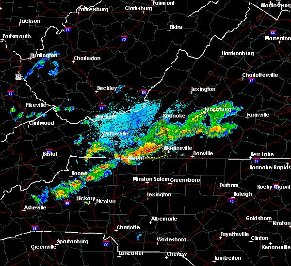 At 939 pm edt, severe thunderstorms were located along a line extending from near philpott dam to near patrick springs, and are nearly stationary (radar indicated). Hazards include 60 mph wind gusts and quarter size hail. Hail damage to vehicles is expected. Expect wind damage to roofs, siding, and trees. At 939 pm edt, severe thunderstorms were located along a line extending from near philpott dam to near patrick springs, and are nearly stationary (radar indicated). Hazards include 60 mph wind gusts and quarter size hail. Hail damage to vehicles is expected. Expect wind damage to roofs, siding, and trees.
|
| 7/22/2018 10:11 PM EDT |
 The severe thunderstorm warning for pittsylvania, henry and southeastern franklin counties, the city of danville and the city of martinsville will expire at 1015 pm edt, the storms which prompted the warning have weakened below severe limits, and no longer pose an immediate threat to life or property. therefore, the warning will be allowed to expire. however gusty winds and heavy rain are still possible with these thunderstorms. when it is safe to do so, please send your reports of hail of any size, as well as reports of any wind damage, including downed trees or large limbs, to the national weather service by calling toll free at 1, 8 6 6, 2 1 5, 4 3 2 4. reports and pictures can also be shared on the national weather service blacksburg facebook page and on twitter. The severe thunderstorm warning for pittsylvania, henry and southeastern franklin counties, the city of danville and the city of martinsville will expire at 1015 pm edt, the storms which prompted the warning have weakened below severe limits, and no longer pose an immediate threat to life or property. therefore, the warning will be allowed to expire. however gusty winds and heavy rain are still possible with these thunderstorms. when it is safe to do so, please send your reports of hail of any size, as well as reports of any wind damage, including downed trees or large limbs, to the national weather service by calling toll free at 1, 8 6 6, 2 1 5, 4 3 2 4. reports and pictures can also be shared on the national weather service blacksburg facebook page and on twitter.
|
| 7/22/2018 10:00 PM EDT |
 At 958 pm edt, severe thunderstorms were located along a line extending from near dry fork to near philpott dam, moving north at 30 mph (radar indicated). Hazards include 60 mph wind gusts and quarter size hail. Hail damage to vehicles is expected. expect wind damage to roofs, siding, and trees. locations impacted include, danville, martinsville, altavista, hurt, and chatham. This includes the following locations the martinsville speedway, martinsville airport, and danville airport. At 958 pm edt, severe thunderstorms were located along a line extending from near dry fork to near philpott dam, moving north at 30 mph (radar indicated). Hazards include 60 mph wind gusts and quarter size hail. Hail damage to vehicles is expected. expect wind damage to roofs, siding, and trees. locations impacted include, danville, martinsville, altavista, hurt, and chatham. This includes the following locations the martinsville speedway, martinsville airport, and danville airport.
|
| 7/22/2018 9:23 PM EDT |
 At 923 pm edt, severe thunderstorms were located along a line extending from gatewood to near ayersville, moving north at 35 mph (radar indicated). Hazards include 60 mph wind gusts and quarter size hail. Hail damage to vehicles is expected. expect wind damage to roofs, siding, and trees. locations impacted include, danville, martinsville, altavista, hurt, and chatham. This includes the following locations the martinsville speedway, martinsville airport, and danville airport. At 923 pm edt, severe thunderstorms were located along a line extending from gatewood to near ayersville, moving north at 35 mph (radar indicated). Hazards include 60 mph wind gusts and quarter size hail. Hail damage to vehicles is expected. expect wind damage to roofs, siding, and trees. locations impacted include, danville, martinsville, altavista, hurt, and chatham. This includes the following locations the martinsville speedway, martinsville airport, and danville airport.
|
| 7/22/2018 9:08 PM EDT |
 At 907 pm edt, severe thunderstorms were located along a line extending from yanceyville to dillard, moving north at 30 mph (radar indicated). Hazards include 60 mph wind gusts and quarter size hail. Hail damage to vehicles is expected. Expect wind damage to roofs, siding, and trees. At 907 pm edt, severe thunderstorms were located along a line extending from yanceyville to dillard, moving north at 30 mph (radar indicated). Hazards include 60 mph wind gusts and quarter size hail. Hail damage to vehicles is expected. Expect wind damage to roofs, siding, and trees.
|
| 5/10/2018 3:29 PM EDT |
 At 329 pm edt, severe thunderstorms were located along a line extending from near collinsville to hanging rock state park, moving east at 30 mph (radar indicated). Hazards include 60 mph wind gusts and quarter size hail. Hail damage to vehicles is expected. Expect wind damage to roofs, siding, and trees. At 329 pm edt, severe thunderstorms were located along a line extending from near collinsville to hanging rock state park, moving east at 30 mph (radar indicated). Hazards include 60 mph wind gusts and quarter size hail. Hail damage to vehicles is expected. Expect wind damage to roofs, siding, and trees.
|
| 4/15/2018 5:39 PM EDT |
 At 539 pm edt, severe thunderstorms were located along a line extending from near cave spring to sydnorsville, moving north at 50 mph (radar indicated). Hazards include 60 mph wind gusts and quarter size hail. Hail damage to vehicles is expected. expect wind damage to roofs, siding, and trees. locations impacted include, roanoke, salem, martinsville, vinton, and bedford. this includes the following locations the martinsville speedway, the salem fairgrounds, the national d-day memorial, martinsville airport, and roanoke regional airport. A tornado watch remains in effect until 1100 pm edt for north central north carolina, and central, south central, southwestern and west central virginia. At 539 pm edt, severe thunderstorms were located along a line extending from near cave spring to sydnorsville, moving north at 50 mph (radar indicated). Hazards include 60 mph wind gusts and quarter size hail. Hail damage to vehicles is expected. expect wind damage to roofs, siding, and trees. locations impacted include, roanoke, salem, martinsville, vinton, and bedford. this includes the following locations the martinsville speedway, the salem fairgrounds, the national d-day memorial, martinsville airport, and roanoke regional airport. A tornado watch remains in effect until 1100 pm edt for north central north carolina, and central, south central, southwestern and west central virginia.
|
| 4/15/2018 5:28 PM EDT |
 At 528 pm edt, severe thunderstorms were located along a line extending from near bent mountain to figsboro, moving northeast at 50 mph (radar indicated). Hazards include 60 mph wind gusts and quarter size hail. Hail damage to vehicles is expected. expect wind damage to roofs, siding, and trees. locations impacted include, roanoke, salem, martinsville, vinton, and bedford. this includes the following locations the martinsville speedway, the salem fairgrounds, the national d-day memorial, martinsville airport, and roanoke regional airport. A tornado watch remains in effect until 1100 pm edt for north central north carolina, and central, south central, southwestern and west central virginia. At 528 pm edt, severe thunderstorms were located along a line extending from near bent mountain to figsboro, moving northeast at 50 mph (radar indicated). Hazards include 60 mph wind gusts and quarter size hail. Hail damage to vehicles is expected. expect wind damage to roofs, siding, and trees. locations impacted include, roanoke, salem, martinsville, vinton, and bedford. this includes the following locations the martinsville speedway, the salem fairgrounds, the national d-day memorial, martinsville airport, and roanoke regional airport. A tornado watch remains in effect until 1100 pm edt for north central north carolina, and central, south central, southwestern and west central virginia.
|
| 4/15/2018 5:12 PM EDT |
 At 511 pm edt, severe thunderstorms were located along a line extending from near endicott to near price, moving north at 60 mph (radar indicated). Hazards include 60 mph wind gusts and quarter size hail. Hail damage to vehicles is expected. Expect wind damage to roofs, siding, and trees. At 511 pm edt, severe thunderstorms were located along a line extending from near endicott to near price, moving north at 60 mph (radar indicated). Hazards include 60 mph wind gusts and quarter size hail. Hail damage to vehicles is expected. Expect wind damage to roofs, siding, and trees.
|
| 4/15/2018 4:57 PM EDT |
 At 456 pm edt, severe thunderstorms were located along a line extending from near stuart to dillard, moving northeast at 55 mph (radar indicated). Hazards include 60 mph wind gusts and quarter size hail. Hail damage to vehicles is expected. expect wind damage to roofs, siding, and trees. locations impacted include, martinsville, mayodan, madison, stuart, and danbury. this includes the following location martinsville airport. a tornado watch remains in effect until 700 pm edt for northwestern north carolina, and southwestern virginia. A tornado watch also remains in effect until 1100 pm edt for north central north carolina, and south central, southwestern and west central virginia. At 456 pm edt, severe thunderstorms were located along a line extending from near stuart to dillard, moving northeast at 55 mph (radar indicated). Hazards include 60 mph wind gusts and quarter size hail. Hail damage to vehicles is expected. expect wind damage to roofs, siding, and trees. locations impacted include, martinsville, mayodan, madison, stuart, and danbury. this includes the following location martinsville airport. a tornado watch remains in effect until 700 pm edt for northwestern north carolina, and southwestern virginia. A tornado watch also remains in effect until 1100 pm edt for north central north carolina, and south central, southwestern and west central virginia.
|
| 4/15/2018 4:39 PM EDT |
 At 438 pm edt, severe thunderstorms were located along a line extending from near westfield to germanton, moving northeast at 55 mph (radar indicated). Hazards include 60 mph wind gusts and quarter size hail. Hail damage to vehicles is expected. expect wind damage to roofs, siding, and trees. locations impacted include, martinsville, mayodan, madison, pilot mountain, and walnut cove. this includes the following location martinsville airport. a tornado watch remains in effect until 700 pm edt for northwestern north carolina, and southwestern virginia. A tornado watch also remains in effect until 1100 pm edt for north central north carolina, and south central, southwestern and west central virginia. At 438 pm edt, severe thunderstorms were located along a line extending from near westfield to germanton, moving northeast at 55 mph (radar indicated). Hazards include 60 mph wind gusts and quarter size hail. Hail damage to vehicles is expected. expect wind damage to roofs, siding, and trees. locations impacted include, martinsville, mayodan, madison, pilot mountain, and walnut cove. this includes the following location martinsville airport. a tornado watch remains in effect until 700 pm edt for northwestern north carolina, and southwestern virginia. A tornado watch also remains in effect until 1100 pm edt for north central north carolina, and south central, southwestern and west central virginia.
|
| 4/15/2018 4:39 PM EDT |
 A severe thunderstorm warning remains in effect until 515 pm edt for eastern surry. stokes. northwestern rockingham. western henry and patrick counties and the city of martinsville. At 438 pm edt, severe thunderstorms were located along a line extending from near westfield to germanton, moving northeast at 55. A severe thunderstorm warning remains in effect until 515 pm edt for eastern surry. stokes. northwestern rockingham. western henry and patrick counties and the city of martinsville. At 438 pm edt, severe thunderstorms were located along a line extending from near westfield to germanton, moving northeast at 55.
|
| 4/15/2018 4:08 PM EDT |
 At 407 pm edt, a severe thunderstorm was located near mocksville, moving northeast at 65 mph (radar indicated). Hazards include 60 mph wind gusts and quarter size hail. Hail damage to vehicles is expected. Expect wind damage to roofs, siding, and trees. At 407 pm edt, a severe thunderstorm was located near mocksville, moving northeast at 65 mph (radar indicated). Hazards include 60 mph wind gusts and quarter size hail. Hail damage to vehicles is expected. Expect wind damage to roofs, siding, and trees.
|
| 10/23/2017 7:43 PM EDT |
 The severe thunderstorm warning for northeastern stokes. rockingham. east central floyd. southwestern pittsylvania. henry. franklin and eastern patrick counties and the city of martinsville will expire at 745 pm edt. the storms which prompted the warning have moved out of the area. Therefore the warning will be allowed to expire. The severe thunderstorm warning for northeastern stokes. rockingham. east central floyd. southwestern pittsylvania. henry. franklin and eastern patrick counties and the city of martinsville will expire at 745 pm edt. the storms which prompted the warning have moved out of the area. Therefore the warning will be allowed to expire.
|
| 10/23/2017 6:46 PM EDT |
 At 645 pm edt, severe thunderstorms were located along a line extending from near floyd to near ellisboro, moving northeast at 15 mph (radar indicated). Hazards include 60 mph wind gusts and quarter size hail. Hail damage to vehicles is expected. Expect wind damage to roofs, siding, and trees. At 645 pm edt, severe thunderstorms were located along a line extending from near floyd to near ellisboro, moving northeast at 15 mph (radar indicated). Hazards include 60 mph wind gusts and quarter size hail. Hail damage to vehicles is expected. Expect wind damage to roofs, siding, and trees.
|
| 7/14/2017 12:53 PM EDT |
 At 1253 pm edt, severe thunderstorms were located along a line extending from oak level through sanville to stuart, moving southeast at 15 mph (radar indicated). Hazards include 60 mph wind gusts and quarter size hail. Hail damage to vehicles is expected. Expect wind damage to roofs, siding, and trees. At 1253 pm edt, severe thunderstorms were located along a line extending from oak level through sanville to stuart, moving southeast at 15 mph (radar indicated). Hazards include 60 mph wind gusts and quarter size hail. Hail damage to vehicles is expected. Expect wind damage to roofs, siding, and trees.
|
| 5/24/2017 6:22 PM EDT | One tree down near the intersection of old quarry road and daniels creek road in henry county VA, 5.1 miles WSW of Bassett, VA |
| 5/24/2017 6:12 PM EDT |
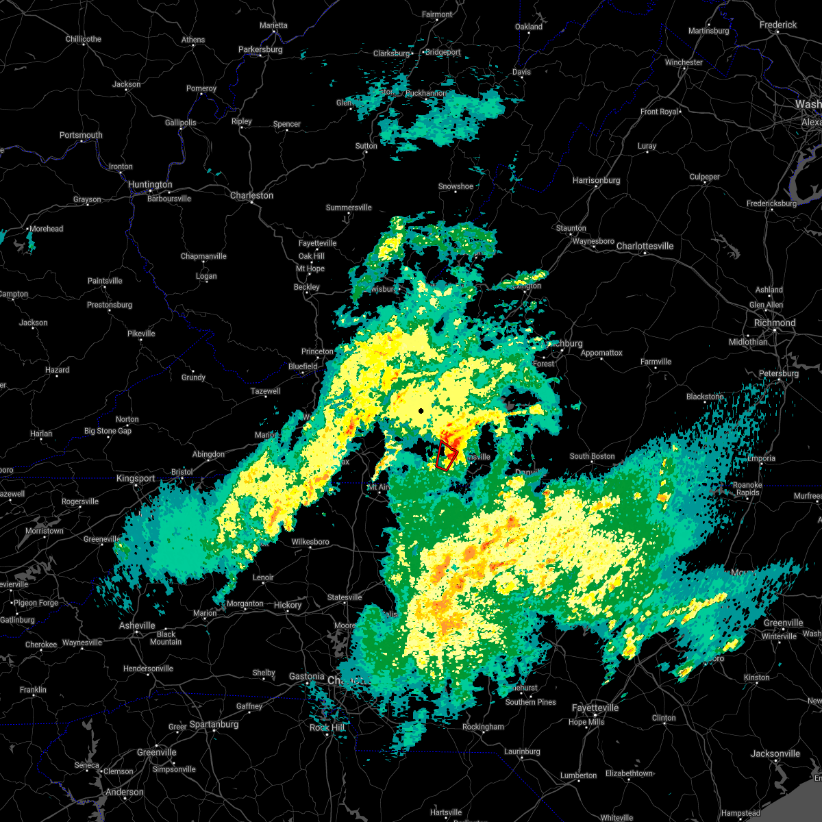 The tornado warning for west central henry and east central patrick counties will expire at 615 pm edt. the storm which prompted the warning has weakened and no longer appears capable of producing a tornado. Therefore the warning will be allowed to expire. The tornado warning for west central henry and east central patrick counties will expire at 615 pm edt. the storm which prompted the warning has weakened and no longer appears capable of producing a tornado. Therefore the warning will be allowed to expire.
|
| 5/24/2017 6:11 PM EDT |
 At 610 pm edt, a severe thunderstorm was located over sanville, moving northeast at 25 mph (radar indicated). Hazards include 60 mph wind gusts and quarter size hail. Hail damage to vehicles is expected. Expect wind damage to roofs, siding, and trees. At 610 pm edt, a severe thunderstorm was located over sanville, moving northeast at 25 mph (radar indicated). Hazards include 60 mph wind gusts and quarter size hail. Hail damage to vehicles is expected. Expect wind damage to roofs, siding, and trees.
|
| 5/24/2017 6:04 PM EDT | One tree down near the intersection of saddleridge road and microfilm road in patrick county VA, 6.1 miles E of Bassett, VA |
| 5/24/2017 6:03 PM EDT |
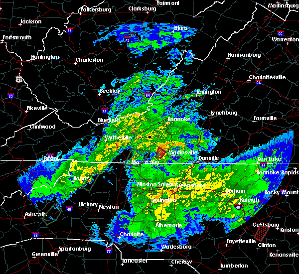 At 603 pm edt, a severe thunderstorm capable of producing a tornado was located over sanville, moving northeast at 30 mph (radar indicated rotation). Hazards include tornado and quarter size hail. Flying debris will be dangerous to those caught without shelter. mobile homes will be damaged or destroyed. damage to roofs, windows, and vehicles will occur. tree damage is likely. Locations impacted include, bassett, sanville, philpott dam, and fairy stone state park. At 603 pm edt, a severe thunderstorm capable of producing a tornado was located over sanville, moving northeast at 30 mph (radar indicated rotation). Hazards include tornado and quarter size hail. Flying debris will be dangerous to those caught without shelter. mobile homes will be damaged or destroyed. damage to roofs, windows, and vehicles will occur. tree damage is likely. Locations impacted include, bassett, sanville, philpott dam, and fairy stone state park.
|
| 5/24/2017 5:49 PM EDT |
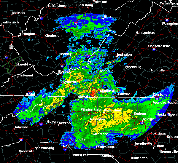 At 548 pm edt, a severe thunderstorm capable of producing a tornado was located over critz, moving northeast at 25 mph (radar indicated rotation). Hazards include tornado and quarter size hail. Flying debris will be dangerous to those caught without shelter. mobile homes will be damaged or destroyed. damage to roofs, windows, and vehicles will occur. tree damage is likely. Locations impacted include, bassett, sanville, philpott dam, patrick springs, and fairy stone state park. At 548 pm edt, a severe thunderstorm capable of producing a tornado was located over critz, moving northeast at 25 mph (radar indicated rotation). Hazards include tornado and quarter size hail. Flying debris will be dangerous to those caught without shelter. mobile homes will be damaged or destroyed. damage to roofs, windows, and vehicles will occur. tree damage is likely. Locations impacted include, bassett, sanville, philpott dam, patrick springs, and fairy stone state park.
|
| 5/24/2017 5:34 PM EDT |
 At 533 pm edt, a severe thunderstorm capable of producing a tornado was located near collinstown, moving northeast at 25 mph (radar indicated rotation). Hazards include tornado and quarter size hail. Flying debris will be dangerous to those caught without shelter. mobile homes will be damaged or destroyed. damage to roofs, windows, and vehicles will occur. Tree damage is likely. At 533 pm edt, a severe thunderstorm capable of producing a tornado was located near collinstown, moving northeast at 25 mph (radar indicated rotation). Hazards include tornado and quarter size hail. Flying debris will be dangerous to those caught without shelter. mobile homes will be damaged or destroyed. damage to roofs, windows, and vehicles will occur. Tree damage is likely.
|
| 5/19/2017 2:23 PM EDT |
 At 223 pm edt, a severe thunderstorm was located over critz, moving east at 20 mph (radar indicated). Hazards include 60 mph wind gusts and quarter size hail. Minor damage to vehicles is possible. expect wind damage to trees and power lines. Locations impacted include, martinsville, stuart, spencer, axton, and ararat. At 223 pm edt, a severe thunderstorm was located over critz, moving east at 20 mph (radar indicated). Hazards include 60 mph wind gusts and quarter size hail. Minor damage to vehicles is possible. expect wind damage to trees and power lines. Locations impacted include, martinsville, stuart, spencer, axton, and ararat.
|
| 5/19/2017 2:05 PM EDT |
 At 204 pm edt, a severe thunderstorm was located over patrick springs, moving east at 25 mph. this warning replaces severe thunderstorm warnings 60 and 62 (radar indicated). Hazards include 60 mph wind gusts and quarter size hail. Minor damage to vehicles is possible. Expect wind damage to trees and power lines. At 204 pm edt, a severe thunderstorm was located over patrick springs, moving east at 25 mph. this warning replaces severe thunderstorm warnings 60 and 62 (radar indicated). Hazards include 60 mph wind gusts and quarter size hail. Minor damage to vehicles is possible. Expect wind damage to trees and power lines.
|
| 5/19/2017 1:00 PM EDT |
 At 1235 pm edt, a severe thunderstorm was located over sanville, moving east at 20 mph (radar indicated). Hazards include 60 mph wind gusts. expect damage to trees and power lines At 1235 pm edt, a severe thunderstorm was located over sanville, moving east at 20 mph (radar indicated). Hazards include 60 mph wind gusts. expect damage to trees and power lines
|
| 5/19/2017 12:36 PM EDT |
 At 1235 pm edt, a severe thunderstorm was located over sanville, moving east at 20 mph (radar indicated). Hazards include 60 mph wind gusts. expect damage to trees and power lines At 1235 pm edt, a severe thunderstorm was located over sanville, moving east at 20 mph (radar indicated). Hazards include 60 mph wind gusts. expect damage to trees and power lines
|
| 5/1/2017 6:07 PM EDT |
 At 607 pm edt, severe thunderstorms were located along a line extending from near rocky mount to near price to near kernersville, moving northeast at 45 mph (law enforcement). Hazards include 60 mph wind gusts and quarter size hail. Minor damage to vehicles is possible. expect wind damage to trees and power lines. Locations impacted include, danville, eden, reidsville, martinsville, and wentworth. At 607 pm edt, severe thunderstorms were located along a line extending from near rocky mount to near price to near kernersville, moving northeast at 45 mph (law enforcement). Hazards include 60 mph wind gusts and quarter size hail. Minor damage to vehicles is possible. expect wind damage to trees and power lines. Locations impacted include, danville, eden, reidsville, martinsville, and wentworth.
|
| 5/1/2017 5:32 PM EDT |
 At 530 pm edt, severe thunderstorms were located along a line extending from near woolwine to near hanging rock state park to 7 miles east of mocksville, moving northeast at 45 mph (law enforcement. at 504 pm, yadkin nc county warning point reported multiple trees down in east bend). Hazards include 60 mph wind gusts and quarter size hail. Minor damage to vehicles is possible. Expect wind damage to trees and power lines. At 530 pm edt, severe thunderstorms were located along a line extending from near woolwine to near hanging rock state park to 7 miles east of mocksville, moving northeast at 45 mph (law enforcement. at 504 pm, yadkin nc county warning point reported multiple trees down in east bend). Hazards include 60 mph wind gusts and quarter size hail. Minor damage to vehicles is possible. Expect wind damage to trees and power lines.
|
| 3/31/2017 1:48 PM EDT |
 At 147 pm edt, a severe thunderstorm was located over philpott dam, moving southeast at 15 mph (radar indicated). Hazards include 60 mph wind gusts and quarter size hail. Hail damage to vehicles is expected. expect wind damage to roofs, siding, and trees. Locations impacted include, bassett, collinsville, stanleytown, philpott dam, and figsboro. At 147 pm edt, a severe thunderstorm was located over philpott dam, moving southeast at 15 mph (radar indicated). Hazards include 60 mph wind gusts and quarter size hail. Hail damage to vehicles is expected. expect wind damage to roofs, siding, and trees. Locations impacted include, bassett, collinsville, stanleytown, philpott dam, and figsboro.
|
| 3/31/2017 1:33 PM EDT |
 At 131 pm edt, a severe thunderstorm was located over fairy stone state park, moving southeast at 15 mph (radar indicated). Hazards include 60 mph wind gusts and quarter size hail. Hail damage to vehicles is expected. Expect wind damage to roofs, siding, and trees. At 131 pm edt, a severe thunderstorm was located over fairy stone state park, moving southeast at 15 mph (radar indicated). Hazards include 60 mph wind gusts and quarter size hail. Hail damage to vehicles is expected. Expect wind damage to roofs, siding, and trees.
|
| 9/30/2016 8:19 AM EDT |
 At 818 am edt, a severe thunderstorm was located near callaway, moving north at 30 mph (radar indicated). Hazards include 60 mph wind gusts and quarter size hail. Hail damage to vehicles is expected. expect wind damage to roofs, siding, and trees. Locations impacted include, rocky mount, boones mill, sydnorsville, ferrum, and bassett. At 818 am edt, a severe thunderstorm was located near callaway, moving north at 30 mph (radar indicated). Hazards include 60 mph wind gusts and quarter size hail. Hail damage to vehicles is expected. expect wind damage to roofs, siding, and trees. Locations impacted include, rocky mount, boones mill, sydnorsville, ferrum, and bassett.
|
| 9/30/2016 7:55 AM EDT |
 At 754 am edt, a severe thunderstorm was located near endicott, moving north at 30 mph (radar indicated). Hazards include 60 mph wind gusts and quarter size hail. Hail damage to vehicles is expected. expect wind damage to roofs, siding, and trees. Locations impacted include, rocky mount, boones mill, sydnorsville, ferrum, and bassett. At 754 am edt, a severe thunderstorm was located near endicott, moving north at 30 mph (radar indicated). Hazards include 60 mph wind gusts and quarter size hail. Hail damage to vehicles is expected. expect wind damage to roofs, siding, and trees. Locations impacted include, rocky mount, boones mill, sydnorsville, ferrum, and bassett.
|
| 9/30/2016 7:39 AM EDT |
 At 738 am edt, a severe thunderstorm was located near sanville, moving north at 30 mph (radar indicated). Hazards include two inch hail and 60 mph wind gusts. People and animals outdoors will be injured. expect hail damage to roofs, siding, windows, and vehicles. Expect wind damage to roofs, siding, and trees. At 738 am edt, a severe thunderstorm was located near sanville, moving north at 30 mph (radar indicated). Hazards include two inch hail and 60 mph wind gusts. People and animals outdoors will be injured. expect hail damage to roofs, siding, windows, and vehicles. Expect wind damage to roofs, siding, and trees.
|
| 9/30/2016 7:35 AM EDT |
 At 735 am edt, a severe thunderstorm was located near patrick springs, moving north at 25 mph (radar indicated). Hazards include golf ball size hail and 60 mph wind gusts. People and animals outdoors will be injured. expect hail damage to roofs, siding, windows, and vehicles. expect wind damage to roofs, siding, and trees. Locations impacted include, stuart, woolwine, spencer, bassett, and rocky knob recreation area. At 735 am edt, a severe thunderstorm was located near patrick springs, moving north at 25 mph (radar indicated). Hazards include golf ball size hail and 60 mph wind gusts. People and animals outdoors will be injured. expect hail damage to roofs, siding, windows, and vehicles. expect wind damage to roofs, siding, and trees. Locations impacted include, stuart, woolwine, spencer, bassett, and rocky knob recreation area.
|
| 9/30/2016 7:28 AM EDT |
 At 728 am edt, a severe thunderstorm was located over patrick springs, moving north at 25 mph (radar indicated). Hazards include golf ball size hail and 60 mph wind gusts. People and animals outdoors will be injured. expect hail damage to roofs, siding, windows, and vehicles. expect wind damage to roofs, siding, and trees. Locations impacted include, stuart, danbury, sandy ridge, woolwine, and spencer. At 728 am edt, a severe thunderstorm was located over patrick springs, moving north at 25 mph (radar indicated). Hazards include golf ball size hail and 60 mph wind gusts. People and animals outdoors will be injured. expect hail damage to roofs, siding, windows, and vehicles. expect wind damage to roofs, siding, and trees. Locations impacted include, stuart, danbury, sandy ridge, woolwine, and spencer.
|
| 9/30/2016 7:10 AM EDT |
 At 657 am edt, a severe thunderstorm was located near danbury, moving north at 25 mph (radar indicated). Hazards include 60 mph wind gusts and quarter size hail. Hail damage to vehicles is expected. Expect wind damage to roofs, siding, and trees. At 657 am edt, a severe thunderstorm was located near danbury, moving north at 25 mph (radar indicated). Hazards include 60 mph wind gusts and quarter size hail. Hail damage to vehicles is expected. Expect wind damage to roofs, siding, and trees.
|
| 9/30/2016 6:58 AM EDT |
 At 657 am edt, a severe thunderstorm was located near danbury, moving north at 25 mph (radar indicated). Hazards include 60 mph wind gusts and quarter size hail. Hail damage to vehicles is expected. Expect wind damage to roofs, siding, and trees. At 657 am edt, a severe thunderstorm was located near danbury, moving north at 25 mph (radar indicated). Hazards include 60 mph wind gusts and quarter size hail. Hail damage to vehicles is expected. Expect wind damage to roofs, siding, and trees.
|
| 9/29/2016 5:13 PM EDT |
 At 513 pm edt, a severe thunderstorm was located over horse pasture, moving northeast at 20 mph (radar indicated). Hazards include quarter size hail. damage to vehicles is expected At 513 pm edt, a severe thunderstorm was located over horse pasture, moving northeast at 20 mph (radar indicated). Hazards include quarter size hail. damage to vehicles is expected
|
| 9/27/2016 5:36 PM EDT |
 At 535 pm edt, a severe thunderstorm was located over figsboro, moving east at 20 mph (radar indicated). Hazards include 60 mph wind gusts and quarter size hail. Hail damage to vehicles is expected. expect wind damage to roofs, siding, and trees. Locations impacted include, martinsville, axton, leatherwood, villa heights, and collinsville. At 535 pm edt, a severe thunderstorm was located over figsboro, moving east at 20 mph (radar indicated). Hazards include 60 mph wind gusts and quarter size hail. Hail damage to vehicles is expected. expect wind damage to roofs, siding, and trees. Locations impacted include, martinsville, axton, leatherwood, villa heights, and collinsville.
|
| 9/27/2016 5:24 PM EDT | Tree down over road at 600 block of basset dr. time radar estimate in henry county VA, 1.2 miles SSW of Bassett, VA |
| 9/27/2016 5:20 PM EDT |
 At 520 pm edt, a severe thunderstorm was located over bassett, moving east-southeast at 20 mph (radar indicated). Hazards include 60 mph wind gusts and quarter size hail. Hail damage to vehicles is expected. Expect wind damage to roofs, siding, and trees. At 520 pm edt, a severe thunderstorm was located over bassett, moving east-southeast at 20 mph (radar indicated). Hazards include 60 mph wind gusts and quarter size hail. Hail damage to vehicles is expected. Expect wind damage to roofs, siding, and trees.
|
| 9/27/2016 5:18 PM EDT | Tree down on mary hunter dr. time radar estimate in henry county VA, 1.5 miles NE of Bassett, VA |
| 9/27/2016 5:11 PM EDT | Tree down over road at 7100 block of fairystone park hwy. time radar estimate in henry county VA, 3.2 miles E of Bassett, VA |
| 8/17/2016 4:08 PM EDT |
 At 406 pm edt, severe thunderstorms were located along a line extending from snow creek to near stoneville, moving east at 25 mph (radar indicated). Hazards include 60 mph wind gusts and quarter size hail. Hail damage to vehicles is expected. expect wind damage to roofs, siding, and trees. locations impacted include, eden, martinsville, axton, callands, and spencer. This includes the following locations the martinsville speedway and martinsville airport. At 406 pm edt, severe thunderstorms were located along a line extending from snow creek to near stoneville, moving east at 25 mph (radar indicated). Hazards include 60 mph wind gusts and quarter size hail. Hail damage to vehicles is expected. expect wind damage to roofs, siding, and trees. locations impacted include, eden, martinsville, axton, callands, and spencer. This includes the following locations the martinsville speedway and martinsville airport.
|
| 8/17/2016 3:43 PM EDT |
 At 343 pm edt, severe thunderstorms were located along a line extending from near oak level to prestonville, moving east at 25 mph (radar indicated). Hazards include 60 mph wind gusts and quarter size hail. Hail damage to vehicles is expected. Expect wind damage to roofs, siding, and trees. At 343 pm edt, severe thunderstorms were located along a line extending from near oak level to prestonville, moving east at 25 mph (radar indicated). Hazards include 60 mph wind gusts and quarter size hail. Hail damage to vehicles is expected. Expect wind damage to roofs, siding, and trees.
|
| 7/27/2016 5:42 PM EDT |
 The severe thunderstorm warning for southeastern franklin and northern henry counties will expire at 545 pm edt, the storm which prompted the warning has weakened below severe limits, and has exited the warned area. therefore the warning will be allowed to expire. however gusty winds and heavy rain are still possible with this thunderstorm. when it is safe to do so, please send your reports of hail of any size, as well as any reports of wind damage, including downed trees or large limbs, to the national weather service by calling toll free at 1, 8 6 6, 2 1 5, 4 3 2 4. reports and pictures can also be shared on the national weather service blacksburg facebook page and on twitter. be advised that, while this warning has ended, a severe thunderstorm warning is in effect for henry county until 615pm edt. The severe thunderstorm warning for southeastern franklin and northern henry counties will expire at 545 pm edt, the storm which prompted the warning has weakened below severe limits, and has exited the warned area. therefore the warning will be allowed to expire. however gusty winds and heavy rain are still possible with this thunderstorm. when it is safe to do so, please send your reports of hail of any size, as well as any reports of wind damage, including downed trees or large limbs, to the national weather service by calling toll free at 1, 8 6 6, 2 1 5, 4 3 2 4. reports and pictures can also be shared on the national weather service blacksburg facebook page and on twitter. be advised that, while this warning has ended, a severe thunderstorm warning is in effect for henry county until 615pm edt.
|
| 7/27/2016 5:28 PM EDT |
 At 527 pm edt, a severe thunderstorm was located over villa heights, moving northeast at 10 mph (radar indicated). Hazards include ping pong ball size hail and 60 mph wind gusts. People and animals outdoors will be injured. expect hail damage to roofs, siding, windows, and vehicles. expect wind damage to roofs, siding, and trees. locations impacted include, martinsville, axton, spencer, bassett, and leatherwood. This includes the following locations the martinsville speedway and martinsville airport. At 527 pm edt, a severe thunderstorm was located over villa heights, moving northeast at 10 mph (radar indicated). Hazards include ping pong ball size hail and 60 mph wind gusts. People and animals outdoors will be injured. expect hail damage to roofs, siding, windows, and vehicles. expect wind damage to roofs, siding, and trees. locations impacted include, martinsville, axton, spencer, bassett, and leatherwood. This includes the following locations the martinsville speedway and martinsville airport.
|
| 7/27/2016 5:22 PM EDT |
 At 521 pm edt, a severe thunderstorm was located over snow creek, moving east at 20 mph (radar indicated). Hazards include 60 mph wind gusts. Expect damage to roofs. siding. and trees. Locations impacted include, sydnorsville, bassett, leatherwood, philpott dam, and collinsville. At 521 pm edt, a severe thunderstorm was located over snow creek, moving east at 20 mph (radar indicated). Hazards include 60 mph wind gusts. Expect damage to roofs. siding. and trees. Locations impacted include, sydnorsville, bassett, leatherwood, philpott dam, and collinsville.
|
| 7/27/2016 5:11 PM EDT |
 At 511 pm edt, a severe thunderstorm was located over figsboro, moving east at 20 mph (radar indicated). Hazards include 60 mph wind gusts and quarter size hail. Hail damage to vehicles is expected. expect wind damage to roofs, siding, and trees. Locations impacted include, sydnorsville, bassett, leatherwood, fairy stone state park, and oak level. At 511 pm edt, a severe thunderstorm was located over figsboro, moving east at 20 mph (radar indicated). Hazards include 60 mph wind gusts and quarter size hail. Hail damage to vehicles is expected. expect wind damage to roofs, siding, and trees. Locations impacted include, sydnorsville, bassett, leatherwood, fairy stone state park, and oak level.
|
| 7/27/2016 5:08 PM EDT |
 At 508 pm edt, a severe thunderstorm was located over horse pasture, moving northeast at 10 mph (radar indicated). Hazards include ping pong ball size hail and 60 mph wind gusts. People and animals outdoors will be injured. expect hail damage to roofs, siding, windows, and vehicles. Expect wind damage to roofs, siding, and trees. At 508 pm edt, a severe thunderstorm was located over horse pasture, moving northeast at 10 mph (radar indicated). Hazards include ping pong ball size hail and 60 mph wind gusts. People and animals outdoors will be injured. expect hail damage to roofs, siding, windows, and vehicles. Expect wind damage to roofs, siding, and trees.
|
| 7/27/2016 5:00 PM EDT | Tree down on murry hill road in henry county VA, 2.9 miles W of Bassett, VA |
| 7/27/2016 4:53 PM EDT |
 At 453 pm edt, a severe thunderstorm was located near oak level, moving east at 20 mph (radar indicated). Hazards include 60 mph wind gusts and quarter size hail. Hail damage to vehicles is expected. expect wind damage to roofs, siding, and trees. Locations impacted include, sydnorsville, bassett, leatherwood, fairy stone state park, and oak level. At 453 pm edt, a severe thunderstorm was located near oak level, moving east at 20 mph (radar indicated). Hazards include 60 mph wind gusts and quarter size hail. Hail damage to vehicles is expected. expect wind damage to roofs, siding, and trees. Locations impacted include, sydnorsville, bassett, leatherwood, fairy stone state park, and oak level.
|
| 7/27/2016 4:43 PM EDT |
 At 442 pm edt, a severe thunderstorm was located near ferrum, moving east at 20 mph (radar indicated). Hazards include 60 mph wind gusts and quarter size hail. Hail damage to vehicles is expected. Expect wind damage to roofs, siding, and trees. At 442 pm edt, a severe thunderstorm was located near ferrum, moving east at 20 mph (radar indicated). Hazards include 60 mph wind gusts and quarter size hail. Hail damage to vehicles is expected. Expect wind damage to roofs, siding, and trees.
|
| 7/27/2016 4:33 PM EDT |
 At 433 pm edt, severe thunderstorms were located along a line extending from near rocky mount to near endicott, moving southeast at 10 mph (radar indicated). Hazards include 60 mph wind gusts and quarter size hail. Hail damage to vehicles is expected. expect wind damage to roofs, siding, and trees. Locations impacted include, rocky mount, sydnorsville, ferrum, bassett, and philpott dam. At 433 pm edt, severe thunderstorms were located along a line extending from near rocky mount to near endicott, moving southeast at 10 mph (radar indicated). Hazards include 60 mph wind gusts and quarter size hail. Hail damage to vehicles is expected. expect wind damage to roofs, siding, and trees. Locations impacted include, rocky mount, sydnorsville, ferrum, bassett, and philpott dam.
|
| 7/27/2016 4:21 PM EDT |
 At 420 pm edt, severe thunderstorms were located along a line extending from near rocky mount to near endicott, moving southeast at 10 mph (radar indicated). Hazards include 60 mph wind gusts and quarter size hail. Hail damage to vehicles is expected. Expect wind damage to roofs, siding, and trees. At 420 pm edt, severe thunderstorms were located along a line extending from near rocky mount to near endicott, moving southeast at 10 mph (radar indicated). Hazards include 60 mph wind gusts and quarter size hail. Hail damage to vehicles is expected. Expect wind damage to roofs, siding, and trees.
|
| 7/14/2016 3:30 PM EDT |
 At 330 pm edt, a severe thunderstorm was located over buffalo ridge, moving east at 40 mph (radar indicated). Hazards include 60 mph wind gusts and quarter size hail. Hail damage to vehicles is expected. Expect wind damage to roofs, siding, and trees. At 330 pm edt, a severe thunderstorm was located over buffalo ridge, moving east at 40 mph (radar indicated). Hazards include 60 mph wind gusts and quarter size hail. Hail damage to vehicles is expected. Expect wind damage to roofs, siding, and trees.
|
| 7/14/2016 3:19 PM EDT | Trees and power lines down in henry county VA, 0.3 miles SSW of Bassett, VA |
| 7/8/2016 5:37 PM EDT |
 At 537 pm edt, severe thunderstorms were located along a line extending from near sontag to oak level to philpott dam, moving east at 35 mph (radar indicated). Hazards include 60 mph wind gusts and quarter size hail. Hail damage to vehicles is expected. Expect wind damage to roofs, siding, and trees. At 537 pm edt, severe thunderstorms were located along a line extending from near sontag to oak level to philpott dam, moving east at 35 mph (radar indicated). Hazards include 60 mph wind gusts and quarter size hail. Hail damage to vehicles is expected. Expect wind damage to roofs, siding, and trees.
|
| 7/8/2016 5:35 PM EDT | Multiple large trees were blown down in the community of basset in henry county VA, 0.3 miles SSW of Bassett, VA |
| 7/2/2016 11:14 PM EDT |
 At 1112 pm edt, severe thunderstorms were located between leatherwood and collinsville, moving southeast at 15 mph (radar indicated). Hazards include 60 mph wind gusts. Expect damage to roofs. siding. and trees. locations impacted include, martinsville, axton, bassett, leatherwood, and villa heights. This includes the martinsville speedway and martinsville airport. At 1112 pm edt, severe thunderstorms were located between leatherwood and collinsville, moving southeast at 15 mph (radar indicated). Hazards include 60 mph wind gusts. Expect damage to roofs. siding. and trees. locations impacted include, martinsville, axton, bassett, leatherwood, and villa heights. This includes the martinsville speedway and martinsville airport.
|
| 7/2/2016 10:52 PM EDT |
 At 1051 pm edt, a severe thunderstorm was located between bassett and ferrum, moving southeast at 20 mph (radar indicated). Hazards include 60 mph wind gusts. Expect damage to roofs. siding. And trees. At 1051 pm edt, a severe thunderstorm was located between bassett and ferrum, moving southeast at 20 mph (radar indicated). Hazards include 60 mph wind gusts. Expect damage to roofs. siding. And trees.
|
| 6/16/2016 10:58 PM EDT | The severe thunderstorm warning for alleghany, ashe, patrick, southern grayson, henry and southern carroll counties, the city of martinsville and the city of galax will expire at 1100 pm edt, the storms which prompted the warning have weakened below severe limits, and have exited the warned area. therefore the warning will be allowed to expire. however, heavy rain and wind gusts are still possible with these thunderstorms. when it is safe to do so, please send your reports of hail of any size, as well as any reports of wind damage, including downed trees or large limbs, to the national weather service by calling toll free at 1, 8 6 6, 2 1 5, 4 3 2 4. reports and pictures can also be shared on the national weather service blacksburg facebook page and on twitter. |
| 6/16/2016 10:58 PM EDT | The severe thunderstorm warning for alleghany, ashe, patrick, southern grayson, henry and southern carroll counties, the city of martinsville and the city of galax will expire at 1100 pm edt, the storms which prompted the warning have weakened below severe limits, and have exited the warned area. therefore the warning will be allowed to expire. however, heavy rain and wind gusts are still possible with these thunderstorms. when it is safe to do so, please send your reports of hail of any size, as well as any reports of wind damage, including downed trees or large limbs, to the national weather service by calling toll free at 1, 8 6 6, 2 1 5, 4 3 2 4. reports and pictures can also be shared on the national weather service blacksburg facebook page and on twitter. |
| 6/16/2016 10:34 PM EDT |
 At 1033 pm edt, severe thunderstorms were located along a line extending from near pittsville to near fairy stone state park to fries, moving east at 50 mph (radar indicated). Hazards include 60 mph wind gusts and penny size hail. Expect damage to roofs. siding. and trees. locations impacted include, martinsville, galax, sparta, jefferson, and stuart. This includes the martinsville speedway and martinsville airport. At 1033 pm edt, severe thunderstorms were located along a line extending from near pittsville to near fairy stone state park to fries, moving east at 50 mph (radar indicated). Hazards include 60 mph wind gusts and penny size hail. Expect damage to roofs. siding. and trees. locations impacted include, martinsville, galax, sparta, jefferson, and stuart. This includes the martinsville speedway and martinsville airport.
|
| 6/16/2016 10:07 PM EDT |
 At 1007 pm edt, severe thunderstorms were located along a line extending from near burnt chimney to near alum ridge to near rural retreat, moving east at 50 mph (radar indicated). Hazards include 60 mph wind gusts and quarter size hail. Hail damage to vehicles is expected. Expect wind damage to roofs, siding, and trees. At 1007 pm edt, severe thunderstorms were located along a line extending from near burnt chimney to near alum ridge to near rural retreat, moving east at 50 mph (radar indicated). Hazards include 60 mph wind gusts and quarter size hail. Hail damage to vehicles is expected. Expect wind damage to roofs, siding, and trees.
|
| 3/14/2016 8:23 PM EDT | The severe thunderstorm warning for central henry and the city of martinsville will expire at 830 pm edt, the storm which prompted the warning has weakened below severe limits, and no longer poses an immediate threat to life or property. therefore the warning will be allowed to expire. when it is safe to do so, please send your reports of hail of any size, as well as any reports of wind damage, including downed trees or large limbs, to the national weather service by calling toll free at 1, 8 6 6, 2 1 5, 4 3 2 4. reports and pictures can also be shared on the national weather service blacksburg facebook page and on twitter. |
| 3/14/2016 8:13 PM EDT | At 812 pm edt, a severe thunderstorm was located over martinsville airport, moving northeast at 30 mph (radar indicated). Hazards include 60 mph wind gusts and quarter size hail. Hail damage to vehicles is expected. expect wind damage to roofs, siding, and trees. locations impacted include, martinsville, martinsville city, axton, spencer, and bassett. This includes the martinsville speedway and martinsville airport. |
| 3/14/2016 8:10 PM EDT | Quarter sized hail reported 2.9 miles W of Bassett, VA |
| 3/14/2016 8:00 PM EDT | At 759 pm edt, a severe thunderstorm was located near price, moving northeast at 30 mph (radar indicated). Hazards include 60 mph wind gusts and quarter size hail. Hail damage to vehicles is expected. expect wind damage to roofs, siding, and trees. locations impacted include, martinsville, stoneville, martinsville city, axton, and spencer. This includes the martinsville speedway and martinsville airport. |
| 3/14/2016 8:00 PM EDT | At 759 pm edt, a severe thunderstorm was located near price, moving northeast at 30 mph (radar indicated). Hazards include 60 mph wind gusts and quarter size hail. Hail damage to vehicles is expected. expect wind damage to roofs, siding, and trees. locations impacted include, martinsville, stoneville, martinsville city, axton, and spencer. This includes the martinsville speedway and martinsville airport. |
| 3/14/2016 7:49 PM EDT | At 749 pm edt, a severe thunderstorm was located over ayersville, moving northeast at 25 mph (radar indicated). Hazards include 60 mph wind gusts and quarter size hail. Hail damage to vehicles is expected. Expect wind damage to roofs, siding, and trees. |
| 3/14/2016 7:49 PM EDT | At 749 pm edt, a severe thunderstorm was located over ayersville, moving northeast at 25 mph (radar indicated). Hazards include 60 mph wind gusts and quarter size hail. Hail damage to vehicles is expected. Expect wind damage to roofs, siding, and trees. |
| 2/24/2016 2:06 PM EST |
 At 205 pm est, a severe thunderstorm was located over collinsville, moving northeast at 30 mph (radar indicated). Hazards include 60 mph wind gusts and quarter size hail. Hail damage to vehicles is expected. expect wind damage to roofs, siding, and trees. locations impacted include, eden, martinsville, rocky mount, martinsville city, and axton. this includes the martinsville speedway and martinsville airport. a tornado watch remains in effect until 700 pm est for north central north carolina. A tornado watch also remains in effect until 900 pm est for south central virginia. At 205 pm est, a severe thunderstorm was located over collinsville, moving northeast at 30 mph (radar indicated). Hazards include 60 mph wind gusts and quarter size hail. Hail damage to vehicles is expected. expect wind damage to roofs, siding, and trees. locations impacted include, eden, martinsville, rocky mount, martinsville city, and axton. this includes the martinsville speedway and martinsville airport. a tornado watch remains in effect until 700 pm est for north central north carolina. A tornado watch also remains in effect until 900 pm est for south central virginia.
|
| 2/24/2016 1:48 PM EST |
 At 148 pm est, a severe thunderstorm was located near bassett, moving northeast at 55 mph (radar indicated). Hazards include 60 mph wind gusts and quarter size hail. Hail damage to vehicles is expected. expect wind damage to roofs, siding, and trees. locations impacted include, eden, martinsville, rocky mount, martinsville city, and axton. this includes the martinsville speedway and martinsville airport. a tornado watch remains in effect until 700 pm est for north central north carolina. A tornado watch also remains in effect until 900 pm est for south central virginia. At 148 pm est, a severe thunderstorm was located near bassett, moving northeast at 55 mph (radar indicated). Hazards include 60 mph wind gusts and quarter size hail. Hail damage to vehicles is expected. expect wind damage to roofs, siding, and trees. locations impacted include, eden, martinsville, rocky mount, martinsville city, and axton. this includes the martinsville speedway and martinsville airport. a tornado watch remains in effect until 700 pm est for north central north carolina. A tornado watch also remains in effect until 900 pm est for south central virginia.
|
| 2/24/2016 1:37 PM EST |
 At 136 pm est, a severe thunderstorm was located near penns store, moving northeast at 55 mph (radar indicated). Hazards include 60 mph wind gusts and quarter size hail. Hail damage to vehicles is expected. Expect wind damage to roofs, siding, and trees. At 136 pm est, a severe thunderstorm was located near penns store, moving northeast at 55 mph (radar indicated). Hazards include 60 mph wind gusts and quarter size hail. Hail damage to vehicles is expected. Expect wind damage to roofs, siding, and trees.
|
| 8/4/2015 4:47 PM EDT |
 At 446 pm edt, a severe thunderstorm was located over stanleytown, moving southeast at 20 mph (radar indicated). Hazards include 60 mph wind gusts and penny size hail. Expect damage to roofs. siding and trees. locations impacted include, martinsville, martinsville city, axton, bassett, and leatherwood. This includes the martinsville speedway and martinsville airport. At 446 pm edt, a severe thunderstorm was located over stanleytown, moving southeast at 20 mph (radar indicated). Hazards include 60 mph wind gusts and penny size hail. Expect damage to roofs. siding and trees. locations impacted include, martinsville, martinsville city, axton, bassett, and leatherwood. This includes the martinsville speedway and martinsville airport.
|
| 8/4/2015 4:39 PM EDT | Multiple trees down in the riverside drive... columbus drive... and mary hunter drive area of basset in henry county VA, 1.1 miles N of Bassett, VA |
| 8/4/2015 4:34 PM EDT | Quarter sized hail reported 1.7 miles S of Bassett, VA, public reports hail of quarter size along blue ridge view dr. just north of the city of bassett in henry county... va. |
| 8/4/2015 4:31 PM EDT |
 At 431 pm edt, a severe thunderstorm was located over bassett, moving southeast at 20 mph (radar indicated). Hazards include 60 mph wind gusts. Expect damage to roofs. Siding and trees. At 431 pm edt, a severe thunderstorm was located over bassett, moving southeast at 20 mph (radar indicated). Hazards include 60 mph wind gusts. Expect damage to roofs. Siding and trees.
|
| 7/13/2015 7:59 PM EDT |
 At 757 pm edt, severe thunderstorms were located along a line extending from near fincastle to copper hill to critz, moving east at 45 mph (radar indicated). Hazards include 60 mph wind gusts. Expect damage to roofs. Siding and trees. At 757 pm edt, severe thunderstorms were located along a line extending from near fincastle to copper hill to critz, moving east at 45 mph (radar indicated). Hazards include 60 mph wind gusts. Expect damage to roofs. Siding and trees.
|
| 6/27/2015 6:59 PM EDT |
 At 658 pm edt, severe thunderstorms were located along a line extending from oak level to near spencer, moving northeast at 15 mph (radar indicated). Hazards include 60 mph wind gusts and quarter size hail. Hail damage to vehicles is expected. Expect wind damage to roofs, siding and trees. At 658 pm edt, severe thunderstorms were located along a line extending from oak level to near spencer, moving northeast at 15 mph (radar indicated). Hazards include 60 mph wind gusts and quarter size hail. Hail damage to vehicles is expected. Expect wind damage to roofs, siding and trees.
|
| 6/22/2015 5:19 PM EDT |
 At 518 pm edt, a severe thunderstorm was located over fieldale, moving east at 25 mph (radar indicated). Hazards include 60 mph wind gusts and quarter size hail. Hail damage to vehicles is expected. expect wind damage to roofs, siding and trees. locations impacted include, martinsville, axton, spencer, bassett, and leatherwood. This includes the martinsville speedway and martinsville airport. At 518 pm edt, a severe thunderstorm was located over fieldale, moving east at 25 mph (radar indicated). Hazards include 60 mph wind gusts and quarter size hail. Hail damage to vehicles is expected. expect wind damage to roofs, siding and trees. locations impacted include, martinsville, axton, spencer, bassett, and leatherwood. This includes the martinsville speedway and martinsville airport.
|
| 6/22/2015 5:05 PM EDT | Quarter sized hail reported 7.7 miles NE of Bassett, VA, mostly pea size hail with some dime to quarter size mixed in. |
| 6/22/2015 4:59 PM EDT | At 458 pm edt, a severe thunderstorm was located near sanville, moving east at 25 mph (radar indicated). Hazards include 60 mph wind gusts and half dollar size hail. Hail damage to vehicles is expected. Expect wind damage to roofs, siding and trees. |
| 6/22/2015 4:59 PM EDT |
 At 458 pm edt, a severe thunderstorm was located near sanville, moving east at 25 mph (radar indicated). Hazards include 60 mph wind gusts and half dollar size hail. Hail damage to vehicles is expected. Expect wind damage to roofs, siding and trees. At 458 pm edt, a severe thunderstorm was located near sanville, moving east at 25 mph (radar indicated). Hazards include 60 mph wind gusts and half dollar size hail. Hail damage to vehicles is expected. Expect wind damage to roofs, siding and trees.
|
| 6/17/2015 6:39 PM EDT | Quarter sized hail reported 3.4 miles WNW of Bassett, VA, quarter sized hail |
| 7/3/2014 4:42 PM EDT | One tree down across saddler ridge roa in henry county VA, 4.5 miles ENE of Bassett, VA |
| 7/3/2014 4:37 PM EDT | One tree down along bowens creek roa in henry county VA, 4.4 miles E of Bassett, VA |
| 7/3/2014 4:26 PM EDT | Two trees down on longview driv in henry county VA, 4.5 miles ENE of Bassett, VA |
| 6/11/2014 8:15 PM EDT | Quarter sized hail reported 2.7 miles E of Bassett, VA, nickel to quarter size hail at philpott dam rd and rt 57. |
| 7/20/2013 1:56 PM EDT | 18 inch diameter tree down blocking intersection of cross creek lane and blackberry roa in henry county VA, 2.4 miles NE of Bassett, VA |
| 7/4/2013 4:30 PM EDT | Several trees down in the state park in patrick county VA, 7.7 miles E of Bassett, VA |
| 4/12/2013 4:18 AM EDT | Several trees and powerlines were blown down on chestnut oak drive. at least one home sustained damag in henry county VA, 5.5 miles E of Bassett, VA |
| 4/12/2013 4:18 AM EDT | Three homes damaged...two cars damamged...a garage destroyed...and several trees and powerlines down on chestnut oak drive. also...a window blew out of a church on fair in henry county VA, 5.5 miles E of Bassett, VA |
| 7/23/2012 3:07 PM EDT | Large tree down on cedar hill driv in henry county VA, 0.3 miles SSW of Bassett, VA |
| 7/23/2012 3:06 PM EDT | Tree down on philpott drive at the entrance to the upper smith river water plan in henry county VA, 2.4 miles S of Bassett, VA |
| 7/3/2012 2:10 PM EDT | One tree down along salt house branch road near the lake in franklin county VA, 4.4 miles SE of Bassett, VA |
| 6/29/2012 9:42 PM EDT | Multiple trees down with telephone poles on fire at 1590 bassett heights roa in henry county VA, 0.3 miles SSW of Bassett, VA |
| 3/24/2012 5:45 PM EDT | Golf Ball sized hail reported 0.3 miles SSW of Bassett, VA |
| 1/1/0001 12:00 AM | Tree down in henry county VA, 2.4 miles ENE of Bassett, VA |
| 1/1/0001 12:00 AM | Trees down on blackberry road near sanvill in henry county VA, 2.8 miles NE of Bassett, VA |
Hail Maps for Bassett, VA


Connect with Interactive Hail Maps