

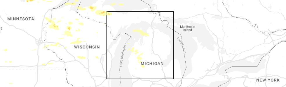
Hail Map for Bay Shore, MI
The Bay Shore, MI area has had 0 reports of on-the-ground hail by trained spotters, and has been under severe weather warnings 0 times during the past 12 months. Doppler radar has detected hail at or near Bay Shore, MI on 7 occasions.
| Name: | Bay Shore, MI |
| Where Located: | 48.4 miles NNE of Traverse City, MI |
| Map: | Google Map for Bay Shore, MI |
| Population: | 754 |
| Housing Units: | 408 |
| More Info: | Search Google for Bay Shore, MI |
3
The Top Recent Hail Date for Bay Shore, MI is Tuesday, August 2, 2022 (3rd out of 7)
Hail and Wind Damage Spotted near Bay Shore, MI
| Date / Time | Report Details |
|---|---|
| 5/20/2022 2:46 PM EDT |
 At 246 pm edt, severe thunderstorms were located along a line extending from grand traverse light to traverse city, moving northeast at 50 mph (radar indicated). Hazards include 60 mph wind gusts and quarter size hail. Hail damage to vehicles is expected. expect wind damage to roofs, siding, and trees. severe thunderstorms will be near, elk rapids, norwood, fishermans island state park and barker creek around 255 pm edt. charlevoix, rapid city, alden, ironton, clam river and kewadin around 300 pm edt. bayshore and horton bay around 305 pm edt. other locations in the path of these severe thunderstorms include petoskey, mancelona, harbor springs, antrim, bay view, conway, oden, petoskey state park, alba, alanson and brutus. hail threat, radar indicated max hail size, 1. 00 in wind threat, radar indicated max wind gust, 60 mph. At 246 pm edt, severe thunderstorms were located along a line extending from grand traverse light to traverse city, moving northeast at 50 mph (radar indicated). Hazards include 60 mph wind gusts and quarter size hail. Hail damage to vehicles is expected. expect wind damage to roofs, siding, and trees. severe thunderstorms will be near, elk rapids, norwood, fishermans island state park and barker creek around 255 pm edt. charlevoix, rapid city, alden, ironton, clam river and kewadin around 300 pm edt. bayshore and horton bay around 305 pm edt. other locations in the path of these severe thunderstorms include petoskey, mancelona, harbor springs, antrim, bay view, conway, oden, petoskey state park, alba, alanson and brutus. hail threat, radar indicated max hail size, 1. 00 in wind threat, radar indicated max wind gust, 60 mph.
|
| 8/29/2021 2:00 PM EDT |
 At 159 pm edt, severe thunderstorms were located along a line extending from pleasant view to near ironton to near torch lake, moving northeast at 50 mph (radar indicated). Hazards include 60 mph wind gusts. Expect damage to roofs, siding, and trees. locations impacted include, petoskey, bay view, petoskey state park, east jordan, conway, alanson, oden, boyne city, clarion and walloon lake. hail threat, radar indicated max hail size, <. 75 in wind threat, radar indicated max wind gust, 60 mph. At 159 pm edt, severe thunderstorms were located along a line extending from pleasant view to near ironton to near torch lake, moving northeast at 50 mph (radar indicated). Hazards include 60 mph wind gusts. Expect damage to roofs, siding, and trees. locations impacted include, petoskey, bay view, petoskey state park, east jordan, conway, alanson, oden, boyne city, clarion and walloon lake. hail threat, radar indicated max hail size, <. 75 in wind threat, radar indicated max wind gust, 60 mph.
|
| 8/29/2021 1:37 PM EDT |
 At 136 pm edt, severe thunderstorms were located along a line extending from near fishermans island state park to peshawbestown to near lake ann, moving northeast at 50 mph (radar indicated). Hazards include 60 mph wind gusts. Expect damage to roofs, siding, and trees. severe thunderstorms will be near, charlevoix and fishermans island state park around 140 pm edt. norwood, bayshore and mapleton around 150 pm edt. elk rapids, harbor springs and ironton around 155 pm edt. other locations in the path of these severe thunderstorms include horton bay, kewadin, petoskey, torch lake, central lake, clarion, walloon lake, ellsworth, bay view, petoskey state park, boyne city, east jordan, conway, alanson, oden, young state park and jordan township. hail threat, radar indicated max hail size, <. 75 in wind threat, radar indicated max wind gust, 60 mph. At 136 pm edt, severe thunderstorms were located along a line extending from near fishermans island state park to peshawbestown to near lake ann, moving northeast at 50 mph (radar indicated). Hazards include 60 mph wind gusts. Expect damage to roofs, siding, and trees. severe thunderstorms will be near, charlevoix and fishermans island state park around 140 pm edt. norwood, bayshore and mapleton around 150 pm edt. elk rapids, harbor springs and ironton around 155 pm edt. other locations in the path of these severe thunderstorms include horton bay, kewadin, petoskey, torch lake, central lake, clarion, walloon lake, ellsworth, bay view, petoskey state park, boyne city, east jordan, conway, alanson, oden, young state park and jordan township. hail threat, radar indicated max hail size, <. 75 in wind threat, radar indicated max wind gust, 60 mph.
|
| 8/11/2021 5:24 PM EDT |
 At 524 pm edt, severe thunderstorms were located along a line extending from harbor springs to horton bay to near central lake, moving east at 50 mph (radar indicated). Hazards include 60 mph wind gusts. Expect damage to roofs, siding, and trees. severe thunderstorms will be near, petoskey, boyne city, conway, walloon lake, clarion, oden, petoskey state park and bay view around 530 pm edt. alanson, burt lake and reasoners corner around 535 pm edt. indian river, boyne falls, wolverine and burt lake state park around 540 pm edt. hail threat, radar indicated max hail size, <. 75 in wind threat, observed max wind gust, 60 mph. At 524 pm edt, severe thunderstorms were located along a line extending from harbor springs to horton bay to near central lake, moving east at 50 mph (radar indicated). Hazards include 60 mph wind gusts. Expect damage to roofs, siding, and trees. severe thunderstorms will be near, petoskey, boyne city, conway, walloon lake, clarion, oden, petoskey state park and bay view around 530 pm edt. alanson, burt lake and reasoners corner around 535 pm edt. indian river, boyne falls, wolverine and burt lake state park around 540 pm edt. hail threat, radar indicated max hail size, <. 75 in wind threat, observed max wind gust, 60 mph.
|
| 7/19/2020 5:26 AM EDT |
 At 525 am edt, severe thunderstorms were located along a line extending from 6 miles north of torch lake to near omena, moving east at 40 mph (radar indicated). Hazards include 60 mph wind gusts and quarter size hail. Hail damage to vehicles is expected. Expect wind damage to roofs, siding, and trees. At 525 am edt, severe thunderstorms were located along a line extending from 6 miles north of torch lake to near omena, moving east at 40 mph (radar indicated). Hazards include 60 mph wind gusts and quarter size hail. Hail damage to vehicles is expected. Expect wind damage to roofs, siding, and trees.
|
| 7/18/2020 5:09 PM EDT |
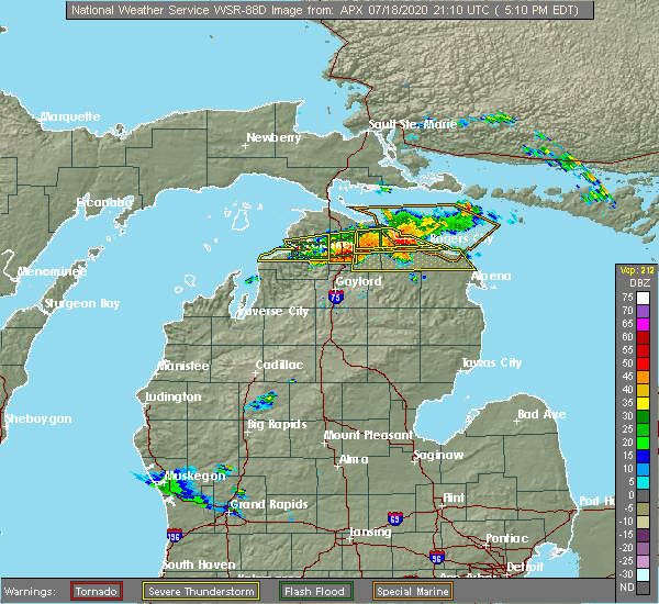 The severe thunderstorm warning for southern emmet and central charlevoix counties will expire at 515 pm edt, the storm which prompted the warning has moved out of the area. therefore, the warning will be allowed to expire. however gusty winds and heavy rain are still possible with this thunderstorm. The severe thunderstorm warning for southern emmet and central charlevoix counties will expire at 515 pm edt, the storm which prompted the warning has moved out of the area. therefore, the warning will be allowed to expire. however gusty winds and heavy rain are still possible with this thunderstorm.
|
| 7/18/2020 4:31 PM EDT |
 At 430 pm edt, a severe thunderstorm was located over bayshore, or near harbor springs, moving east at 45 mph (radar indicated). Hazards include 60 mph wind gusts and quarter size hail. Hail damage to vehicles is expected. Expect wind damage to roofs, siding, and trees. At 430 pm edt, a severe thunderstorm was located over bayshore, or near harbor springs, moving east at 45 mph (radar indicated). Hazards include 60 mph wind gusts and quarter size hail. Hail damage to vehicles is expected. Expect wind damage to roofs, siding, and trees.
|
| 9/30/2019 3:27 PM EDT |
 At 327 pm edt, severe thunderstorms were located along a line extending from 7 miles north of wilderness state park to 14 miles northwest of fishermans island state park, moving southeast at 50 mph (radar indicated). Hazards include 60 mph wind gusts and penny size hail. expect damage to roofs, siding, and trees At 327 pm edt, severe thunderstorms were located along a line extending from 7 miles north of wilderness state park to 14 miles northwest of fishermans island state park, moving southeast at 50 mph (radar indicated). Hazards include 60 mph wind gusts and penny size hail. expect damage to roofs, siding, and trees
|
| 10/4/2018 12:25 AM EDT |
 At 1225 am edt, a severe thunderstorm was located near wolverine, or near indian river, moving east at 50 mph (radar indicated). Hazards include 60 mph wind gusts. Expect damage to roofs, siding, and trees. Locations impacted include, petoskey, boyne city, charlevoix, east jordan, harbor springs, indian river, conway, aloha, alanson, boyne falls, wolverine, aloha state park, young state park, reasoners corner, ironton, horton bay, alverno, clarion, burt lake and walloon lake. At 1225 am edt, a severe thunderstorm was located near wolverine, or near indian river, moving east at 50 mph (radar indicated). Hazards include 60 mph wind gusts. Expect damage to roofs, siding, and trees. Locations impacted include, petoskey, boyne city, charlevoix, east jordan, harbor springs, indian river, conway, aloha, alanson, boyne falls, wolverine, aloha state park, young state park, reasoners corner, ironton, horton bay, alverno, clarion, burt lake and walloon lake.
|
| 10/3/2018 11:54 PM EDT |
 At 1153 pm edt, a severe thunderstorm was located over grand traverse light, moving east at 65 mph (radar indicated). Hazards include 60 mph wind gusts. expect damage to roofs, siding, and trees At 1153 pm edt, a severe thunderstorm was located over grand traverse light, moving east at 65 mph (radar indicated). Hazards include 60 mph wind gusts. expect damage to roofs, siding, and trees
|
| 8/28/2018 1:51 AM EDT |
 At 151 am edt, severe thunderstorms were located along a line extending from hessel to near jordan township, moving east at 50 mph (radar indicated). Hazards include 60 mph wind gusts. Expect damage to roofs, siding, and trees. Locations impacted include, petoskey, boyne city, charlevoix, east jordan, harbor springs, pellston, mackinaw city, conway, carp lake, alanson, bliss, boyne falls, cross village, young state park, stutsmanville, reasoners corner, ironton, pleasant view, horton bay and clarion. At 151 am edt, severe thunderstorms were located along a line extending from hessel to near jordan township, moving east at 50 mph (radar indicated). Hazards include 60 mph wind gusts. Expect damage to roofs, siding, and trees. Locations impacted include, petoskey, boyne city, charlevoix, east jordan, harbor springs, pellston, mackinaw city, conway, carp lake, alanson, bliss, boyne falls, cross village, young state park, stutsmanville, reasoners corner, ironton, pleasant view, horton bay and clarion.
|
| 8/28/2018 1:24 AM EDT |
 At 124 am edt, severe thunderstorms were located along a line extending from near moran to near torch lake, moving east at 50 mph (radar indicated). Hazards include 60 mph wind gusts. expect damage to roofs, siding, and trees At 124 am edt, severe thunderstorms were located along a line extending from near moran to near torch lake, moving east at 50 mph (radar indicated). Hazards include 60 mph wind gusts. expect damage to roofs, siding, and trees
|
| 7/8/2016 11:46 AM EDT |
 At 1146 am edt, a severe thunderstorm was located over torch lake, or 7 miles southwest of ellsworth, moving northeast at 35 mph (radar indicated). Hazards include two inch hail and 70 mph wind gusts. People and animals outdoors will be injured. expect hail damage to roofs, siding, windows, and vehicles. expect considerable tree damage. wind damage is also likely to mobile homes, roofs, and outbuildings. Locations impacted include, petoskey, boyne city, charlevoix, east jordan, ellsworth, torch lake, central lake, norwood, northport, omena, ironton, bayshore, peshawbestown, mapleton, fishermans island state park, young state park, horton bay, old mission, clarion and walloon lake. At 1146 am edt, a severe thunderstorm was located over torch lake, or 7 miles southwest of ellsworth, moving northeast at 35 mph (radar indicated). Hazards include two inch hail and 70 mph wind gusts. People and animals outdoors will be injured. expect hail damage to roofs, siding, windows, and vehicles. expect considerable tree damage. wind damage is also likely to mobile homes, roofs, and outbuildings. Locations impacted include, petoskey, boyne city, charlevoix, east jordan, ellsworth, torch lake, central lake, norwood, northport, omena, ironton, bayshore, peshawbestown, mapleton, fishermans island state park, young state park, horton bay, old mission, clarion and walloon lake.
|
| 7/8/2016 11:29 AM EDT |
 At 1128 am edt, a severe thunderstorm was located near torch lake, or 10 miles south of grand traverse light, moving northeast at 35 mph (radar indicated). Hazards include two inch hail and 70 mph wind gusts. People and animals outdoors will be injured. expect hail damage to roofs, siding, windows, and vehicles. expect considerable tree damage. Wind damage is also likely to mobile homes, roofs, and outbuildings. At 1128 am edt, a severe thunderstorm was located near torch lake, or 10 miles south of grand traverse light, moving northeast at 35 mph (radar indicated). Hazards include two inch hail and 70 mph wind gusts. People and animals outdoors will be injured. expect hail damage to roofs, siding, windows, and vehicles. expect considerable tree damage. Wind damage is also likely to mobile homes, roofs, and outbuildings.
|
| 8/2/2015 11:52 AM EDT |
 At 1151 am edt, severe thunderstorms were located along a line extending from near good hart to bingham, moving east at 55 mph (radar indicated). Hazards include 60 mph wind gusts and quarter size hail. Hail damage to vehicles is expected. Expect wind damage to roofs, siding and trees. At 1151 am edt, severe thunderstorms were located along a line extending from near good hart to bingham, moving east at 55 mph (radar indicated). Hazards include 60 mph wind gusts and quarter size hail. Hail damage to vehicles is expected. Expect wind damage to roofs, siding and trees.
|
Hail Maps for Bay Shore, MI


Connect with Interactive Hail Maps