

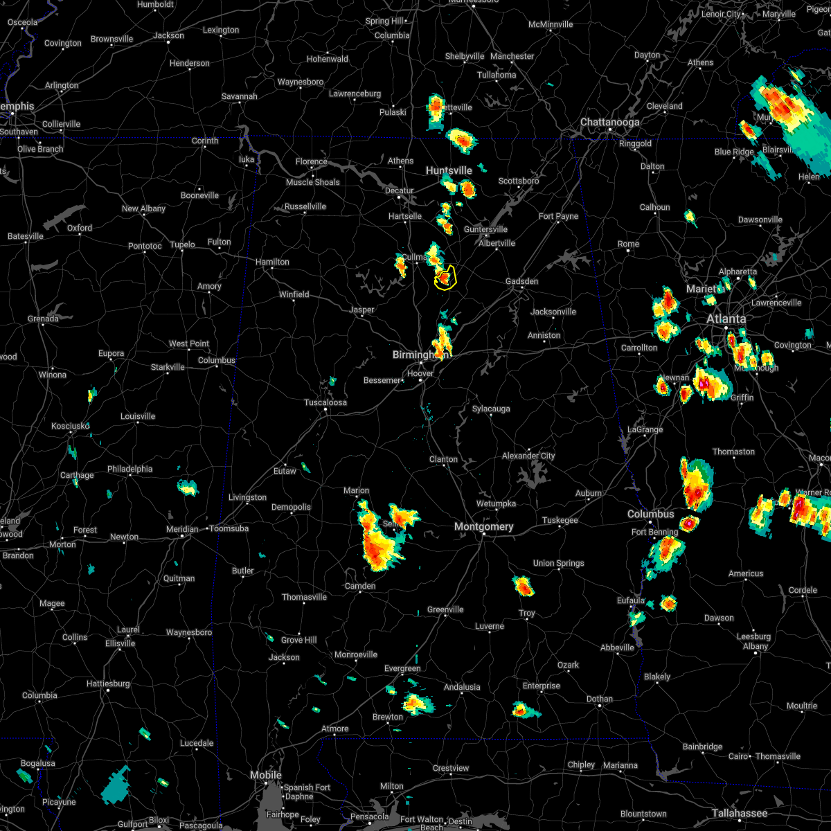
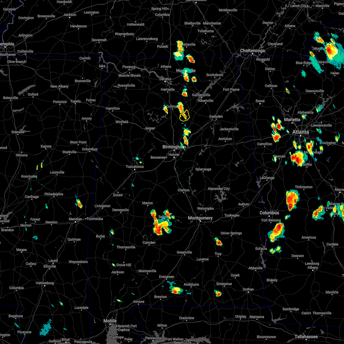
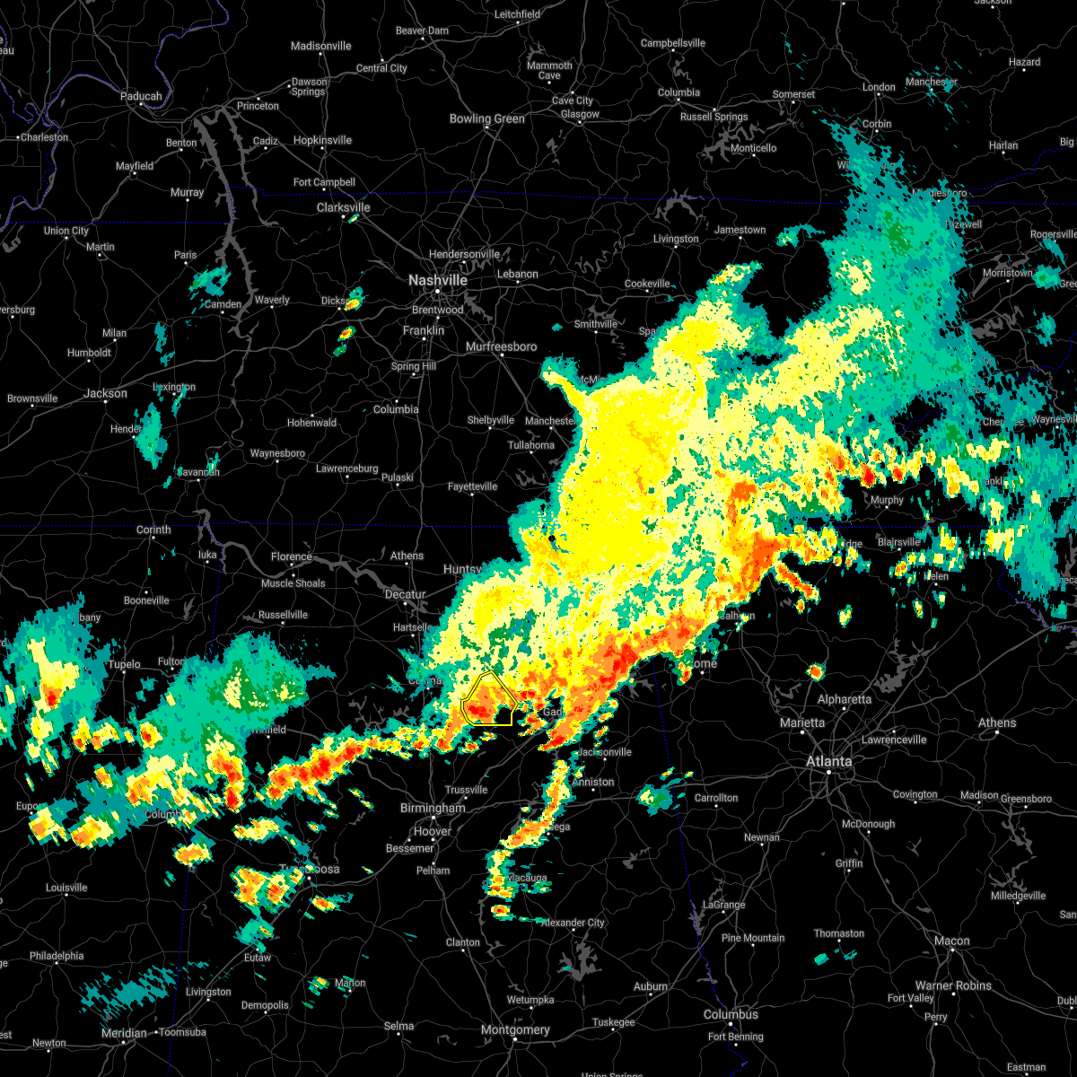
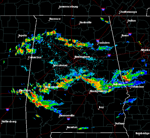
Hail Map for Blountsville, AL
The Blountsville, AL area has had 10 reports of on-the-ground hail by trained spotters, and has been under severe weather warnings 16 times during the past 12 months. Doppler radar has detected hail at or near Blountsville, AL on 64 occasions, including 10 occasions during the past year.
| Name: | Blountsville, AL |
| Where Located: | 40.6 miles NNE of Birmingham, AL |
| Map: | Google Map for Blountsville, AL |
| Population: | 1684 |
| Housing Units: | 791 |
| More Info: | Search Google for Blountsville, AL |
2
The Top Recent Hail Date for Blountsville, AL is Wednesday, June 14, 2023 (10th out of 64)

Hail and Wind Damage Spotted near Blountsville, AL
| Date / Time | Report Details |
|---|---|
| 3/15/2024 6:38 AM CDT |
 Svrbmx the national weather service in birmingham has issued a * severe thunderstorm warning for, blount county in central alabama, etowah county in northeastern alabama, northern st. clair county in central alabama, * until 745 am cdt. * at 638 am cdt, severe thunderstorms were located along a line extending from near mclarty to dallas, moving east at 40 mph (radar indicated). Hazards include 60 mph wind gusts. expect damage to roofs, siding, and trees Svrbmx the national weather service in birmingham has issued a * severe thunderstorm warning for, blount county in central alabama, etowah county in northeastern alabama, northern st. clair county in central alabama, * until 745 am cdt. * at 638 am cdt, severe thunderstorms were located along a line extending from near mclarty to dallas, moving east at 40 mph (radar indicated). Hazards include 60 mph wind gusts. expect damage to roofs, siding, and trees
|
| 8/13/2023 5:55 PM CDT | A couple trees down on county highway 26 and fat dunn rd. winds estimated to be sub-sever in blount county AL, 5.4 miles ENE of Blountsville, AL |
| 8/12/2023 2:44 PM CDT |
 At 243 pm cdt, a severe thunderstorm was located over susan moore, or 8 miles east of blountsville, moving east at 30 mph (radar indicated). Hazards include 60 mph wind gusts. Expect damage to roofs, siding, and trees. locations impacted include, blountsville, altoona, snead, susan moore, walnut grove, brooksville and hendrix. hail threat, radar indicated max hail size, <. 75 in wind threat, radar indicated max wind gust, 60 mph. At 243 pm cdt, a severe thunderstorm was located over susan moore, or 8 miles east of blountsville, moving east at 30 mph (radar indicated). Hazards include 60 mph wind gusts. Expect damage to roofs, siding, and trees. locations impacted include, blountsville, altoona, snead, susan moore, walnut grove, brooksville and hendrix. hail threat, radar indicated max hail size, <. 75 in wind threat, radar indicated max wind gust, 60 mph.
|
| 8/12/2023 2:38 PM CDT | Multiple trees were blown down on highway 79 near blountsville. the highway is impassable in spot in blount county AL, 2.4 miles W of Blountsville, AL |
| 8/12/2023 2:31 PM CDT |
 At 231 pm cdt, a severe thunderstorm was located near blountsville, moving east at 30 mph (radar indicated). Hazards include 60 mph wind gusts. expect damage to roofs, siding, and trees At 231 pm cdt, a severe thunderstorm was located near blountsville, moving east at 30 mph (radar indicated). Hazards include 60 mph wind gusts. expect damage to roofs, siding, and trees
|
| 8/7/2023 3:20 PM CDT |
 The severe thunderstorm warning for blount county will expire at 330 pm cdt, the storm which prompted the warning has moved out of the area. therefore, the warning will be allowed to expire. however gusty winds are still possible with this thunderstorm. a severe thunderstorm watch remains in effect until 700 pm cdt for central and northeastern alabama. The severe thunderstorm warning for blount county will expire at 330 pm cdt, the storm which prompted the warning has moved out of the area. therefore, the warning will be allowed to expire. however gusty winds are still possible with this thunderstorm. a severe thunderstorm watch remains in effect until 700 pm cdt for central and northeastern alabama.
|
| 8/7/2023 2:33 PM CDT |
 At 233 pm cdt, a severe thunderstorm was located near blountsville, moving east at 30 mph (radar indicated). Hazards include 60 mph wind gusts. expect damage to roofs, siding, and trees At 233 pm cdt, a severe thunderstorm was located near blountsville, moving east at 30 mph (radar indicated). Hazards include 60 mph wind gusts. expect damage to roofs, siding, and trees
|
| 8/6/2023 3:23 PM CDT |
 At 323 pm cdt, severe thunderstorms were located along a line extending from near holly pond to county line, moving east at 45 mph (radar indicated). Hazards include 60 mph wind gusts. Expect damage to roofs, siding, and trees. locations impacted include, oneonta, blountsville, cleveland, dallas, locust fork, altoona, snead, susan moore, walnut grove, trafford, allgood, fairview, hayden, nectar, rosa, county line, mclarty, bangor, strawberry and blount springs. hail threat, radar indicated max hail size, <. 75 in wind threat, radar indicated max wind gust, 60 mph. At 323 pm cdt, severe thunderstorms were located along a line extending from near holly pond to county line, moving east at 45 mph (radar indicated). Hazards include 60 mph wind gusts. Expect damage to roofs, siding, and trees. locations impacted include, oneonta, blountsville, cleveland, dallas, locust fork, altoona, snead, susan moore, walnut grove, trafford, allgood, fairview, hayden, nectar, rosa, county line, mclarty, bangor, strawberry and blount springs. hail threat, radar indicated max hail size, <. 75 in wind threat, radar indicated max wind gust, 60 mph.
|
| 8/6/2023 3:09 PM CDT |
 At 309 pm cdt, severe thunderstorms were located along a line extending from 6 miles northeast of cullman to near arkadelphia, moving east at 45 mph (radar indicated). Hazards include 60 mph wind gusts. expect damage to roofs, siding, and trees At 309 pm cdt, severe thunderstorms were located along a line extending from 6 miles northeast of cullman to near arkadelphia, moving east at 45 mph (radar indicated). Hazards include 60 mph wind gusts. expect damage to roofs, siding, and trees
|
| 8/3/2023 1:43 PM CDT |
 At 142 pm cdt, severe thunderstorms were located along a line extending from near strawberry to near smith dam, moving southeast at 25 mph (radar indicated). Hazards include 60 mph wind gusts. expect damage to roofs, siding, and trees At 142 pm cdt, severe thunderstorms were located along a line extending from near strawberry to near smith dam, moving southeast at 25 mph (radar indicated). Hazards include 60 mph wind gusts. expect damage to roofs, siding, and trees
|
| 7/21/2023 4:30 PM CDT |
 At 430 pm cdt, severe thunderstorms were located along a line extending from mclarty to fairview to near kimberly, moving southeast at 25 mph (radar indicated). Hazards include 60 mph wind gusts and quarter size hail. Hail damage to vehicles is expected. Expect wind damage to roofs, siding, and trees. At 430 pm cdt, severe thunderstorms were located along a line extending from mclarty to fairview to near kimberly, moving southeast at 25 mph (radar indicated). Hazards include 60 mph wind gusts and quarter size hail. Hail damage to vehicles is expected. Expect wind damage to roofs, siding, and trees.
|
| 7/21/2023 4:24 PM CDT | Trees were blown down on twin oaks driv in blount county AL, 0.7 miles NE of Blountsville, AL |
| 7/21/2023 4:22 PM CDT | Trees and power lines were blown down near cr 51 and poultry driv in blount county AL, 2.2 miles SE of Blountsville, AL |
| 7/21/2023 4:21 PM CDT | Trees were blown down on cr 4 in blount county AL, 1.8 miles ESE of Blountsville, AL |
| 7/21/2023 4:20 PM CDT | Tree was blown down and blocking the roadway near ketchum road and bullard roa in blount county AL, 2.5 miles SSE of Blountsville, AL |
| 7/18/2023 6:30 PM CDT | Trees and power lines down on lehigh rd.... trafford... and timmerman circle in blountsville. winds estimated between 40-50 mp in blount county AL, 1 miles SSE of Blountsville, AL |
| 6/25/2023 4:34 PM CDT |
 At 434 pm cdt, severe thunderstorms were located along a line extending from tennala to gadsden mall to cleveland, moving southeast at 30 mph (radar indicated). Hazards include 60 mph wind gusts and quarter size hail. Hail damage to vehicles is expected. expect wind damage to roofs, siding, and trees. locations impacted include, gadsden, rainbow city, oneonta, attalla, hokes bluff, centre, cedar bluff, blountsville, cleveland, forney, centre municipal airport, glencoe, leesburg, altoona, snead, susan moore, walnut grove, reece city, allgood and fairview. hail threat, radar indicated max hail size, 1. 00 in wind threat, radar indicated max wind gust, 60 mph. At 434 pm cdt, severe thunderstorms were located along a line extending from tennala to gadsden mall to cleveland, moving southeast at 30 mph (radar indicated). Hazards include 60 mph wind gusts and quarter size hail. Hail damage to vehicles is expected. expect wind damage to roofs, siding, and trees. locations impacted include, gadsden, rainbow city, oneonta, attalla, hokes bluff, centre, cedar bluff, blountsville, cleveland, forney, centre municipal airport, glencoe, leesburg, altoona, snead, susan moore, walnut grove, reece city, allgood and fairview. hail threat, radar indicated max hail size, 1. 00 in wind threat, radar indicated max wind gust, 60 mph.
|
| 6/25/2023 4:19 PM CDT |
 At 419 pm cdt, severe thunderstorms were located along a line extending from sand rock to near reece city to near blountsville, moving southeast at 30 mph (radar indicated). Hazards include 60 mph wind gusts and quarter size hail. Hail damage to vehicles is expected. expect wind damage to roofs, siding, and trees. locations impacted include, gadsden, rainbow city, oneonta, attalla, hokes bluff, centre, cedar bluff, blountsville, cleveland, forney, centre municipal airport, glencoe, sardis city, leesburg, altoona, snead, susan moore, walnut grove, reece city and allgood. hail threat, radar indicated max hail size, 1. 00 in wind threat, radar indicated max wind gust, 60 mph. At 419 pm cdt, severe thunderstorms were located along a line extending from sand rock to near reece city to near blountsville, moving southeast at 30 mph (radar indicated). Hazards include 60 mph wind gusts and quarter size hail. Hail damage to vehicles is expected. expect wind damage to roofs, siding, and trees. locations impacted include, gadsden, rainbow city, oneonta, attalla, hokes bluff, centre, cedar bluff, blountsville, cleveland, forney, centre municipal airport, glencoe, sardis city, leesburg, altoona, snead, susan moore, walnut grove, reece city and allgood. hail threat, radar indicated max hail size, 1. 00 in wind threat, radar indicated max wind gust, 60 mph.
|
| 6/25/2023 4:03 PM CDT |
 At 403 pm cdt, severe thunderstorms were located along a line extending from near crossville to near aurora to near hanceville, moving southeast at 25 mph (radar indicated). Hazards include 60 mph wind gusts and quarter size hail. Hail damage to vehicles is expected. expect wind damage to roofs, siding, and trees. locations impacted include, gadsden, rainbow city, oneonta, attalla, hokes bluff, centre, cedar bluff, blountsville, cleveland, forney, centre municipal airport, glencoe, sardis city, leesburg, altoona, snead, susan moore, walnut grove, reece city and allgood. hail threat, radar indicated max hail size, 1. 00 in wind threat, radar indicated max wind gust, 60 mph. At 403 pm cdt, severe thunderstorms were located along a line extending from near crossville to near aurora to near hanceville, moving southeast at 25 mph (radar indicated). Hazards include 60 mph wind gusts and quarter size hail. Hail damage to vehicles is expected. expect wind damage to roofs, siding, and trees. locations impacted include, gadsden, rainbow city, oneonta, attalla, hokes bluff, centre, cedar bluff, blountsville, cleveland, forney, centre municipal airport, glencoe, sardis city, leesburg, altoona, snead, susan moore, walnut grove, reece city and allgood. hail threat, radar indicated max hail size, 1. 00 in wind threat, radar indicated max wind gust, 60 mph.
|
| 6/25/2023 3:48 PM CDT |
 At 348 pm cdt, severe thunderstorms were located along a line extending from near geraldine to 6 miles northeast of strawberry to 8 miles northeast of cullman, moving southeast at 25 mph (radar indicated). Hazards include 60 mph wind gusts and quarter size hail. Hail damage to vehicles is expected. Expect wind damage to roofs, siding, and trees. At 348 pm cdt, severe thunderstorms were located along a line extending from near geraldine to 6 miles northeast of strawberry to 8 miles northeast of cullman, moving southeast at 25 mph (radar indicated). Hazards include 60 mph wind gusts and quarter size hail. Hail damage to vehicles is expected. Expect wind damage to roofs, siding, and trees.
|
| 6/14/2023 1:25 PM CDT |
 At 124 pm cdt, a severe thunderstorm was located near dodge city, or 15 miles south of cullman, moving southeast at 60 mph (radar indicated). Hazards include 70 mph wind gusts and quarter size hail. Hail damage to vehicles is expected. expect considerable tree damage. Wind damage is also likely to mobile homes, roofs, and outbuildings. At 124 pm cdt, a severe thunderstorm was located near dodge city, or 15 miles south of cullman, moving southeast at 60 mph (radar indicated). Hazards include 70 mph wind gusts and quarter size hail. Hail damage to vehicles is expected. expect considerable tree damage. Wind damage is also likely to mobile homes, roofs, and outbuildings.
|
| 6/14/2023 12:30 PM CDT | Hen Egg sized hail reported 8.6 miles SW of Blountsville, AL |
| 6/14/2023 12:26 PM CDT |
 At 1226 pm cdt, a severe thunderstorm was located over rosa, or near oneonta, moving east at 45 mph (radar indicated). Hazards include 60 mph wind gusts and quarter size hail. Hail damage to vehicles is expected. expect wind damage to roofs, siding, and trees. locations impacted include, oneonta, blountsville, cleveland, locust fork, altoona, snead, susan moore, walnut grove, allgood, fairview, nectar, rosa, highland lake, easley, fowler spring and hendrix. hail threat, radar indicated max hail size, 1. 00 in wind threat, radar indicated max wind gust, 60 mph. At 1226 pm cdt, a severe thunderstorm was located over rosa, or near oneonta, moving east at 45 mph (radar indicated). Hazards include 60 mph wind gusts and quarter size hail. Hail damage to vehicles is expected. expect wind damage to roofs, siding, and trees. locations impacted include, oneonta, blountsville, cleveland, locust fork, altoona, snead, susan moore, walnut grove, allgood, fairview, nectar, rosa, highland lake, easley, fowler spring and hendrix. hail threat, radar indicated max hail size, 1. 00 in wind threat, radar indicated max wind gust, 60 mph.
|
| 6/14/2023 11:59 AM CDT |
 At 1159 am cdt, a severe thunderstorm was located over bangor, or 10 miles west of cleveland, moving east at 35 mph (radar indicated). Hazards include 60 mph wind gusts and quarter size hail. Hail damage to vehicles is expected. Expect wind damage to roofs, siding, and trees. At 1159 am cdt, a severe thunderstorm was located over bangor, or 10 miles west of cleveland, moving east at 35 mph (radar indicated). Hazards include 60 mph wind gusts and quarter size hail. Hail damage to vehicles is expected. Expect wind damage to roofs, siding, and trees.
|
| 3/3/2023 12:10 PM CST | Tree across residence unknown injury and trees down around blountsville elementary. school without power. page street blountsville. time based on rada in blount county AL, 1 miles SSE of Blountsville, AL |
| 3/3/2023 12:08 PM CST |
 At 1207 pm cst, severe thunderstorms were located along a line extending from near strawberry to near woodstock, moving east at 50 mph (radar indicated). Hazards include 60 mph wind gusts. Expect damage to roofs, siding, and trees. locations impacted include, birmingham, hoover, vestavia hills, bessemer, homewood, mountain brook, trussville, hueytown, gardendale, irondale, leeds, moody, fairfield, fultondale, oneonta, centreville, blountsville, cleveland, dallas and center point. hail threat, radar indicated max hail size, <. 75 in wind threat, radar indicated max wind gust, 60 mph. At 1207 pm cst, severe thunderstorms were located along a line extending from near strawberry to near woodstock, moving east at 50 mph (radar indicated). Hazards include 60 mph wind gusts. Expect damage to roofs, siding, and trees. locations impacted include, birmingham, hoover, vestavia hills, bessemer, homewood, mountain brook, trussville, hueytown, gardendale, irondale, leeds, moody, fairfield, fultondale, oneonta, centreville, blountsville, cleveland, dallas and center point. hail threat, radar indicated max hail size, <. 75 in wind threat, radar indicated max wind gust, 60 mph.
|
| 3/3/2023 11:50 AM CST |
 At 1150 am cst, severe thunderstorms were located along a line extending from near hanceville to near low gap, moving east at 40 mph (radar indicated). Hazards include 60 mph wind gusts. Expect damage to roofs, siding, and trees. locations impacted include, birmingham, hoover, vestavia hills, bessemer, homewood, mountain brook, trussville, hueytown, gardendale, irondale, leeds, moody, fairfield, fultondale, oneonta, brent, centreville, blountsville, cleveland and dallas. hail threat, radar indicated max hail size, <. 75 in wind threat, radar indicated max wind gust, 60 mph. At 1150 am cst, severe thunderstorms were located along a line extending from near hanceville to near low gap, moving east at 40 mph (radar indicated). Hazards include 60 mph wind gusts. Expect damage to roofs, siding, and trees. locations impacted include, birmingham, hoover, vestavia hills, bessemer, homewood, mountain brook, trussville, hueytown, gardendale, irondale, leeds, moody, fairfield, fultondale, oneonta, brent, centreville, blountsville, cleveland and dallas. hail threat, radar indicated max hail size, <. 75 in wind threat, radar indicated max wind gust, 60 mph.
|
| 3/3/2023 11:31 AM CST |
 At 1131 am cst, severe thunderstorms were located along a line extending from near smith dam to holt, moving east at 40 mph (radar indicated). Hazards include 60 mph wind gusts. expect damage to roofs, siding, and trees At 1131 am cst, severe thunderstorms were located along a line extending from near smith dam to holt, moving east at 40 mph (radar indicated). Hazards include 60 mph wind gusts. expect damage to roofs, siding, and trees
|
| 8/9/2022 4:00 PM CDT | Trees blown down along cr 55 north of blountsvill in blount county AL, 2.2 miles S of Blountsville, AL |
| 8/9/2022 3:34 PM CDT | Corrects time on previous tstm wnd dmg report from 2 nne blountsville. trees blown down along cr 55 north of blountsville. time estimated by rada in blount county AL, 2.2 miles S of Blountsville, AL |
| 6/15/2022 5:15 PM CDT |
 At 515 pm cdt, a severe thunderstorm was located over blountsville, and is nearly stationary (radar indicated). Hazards include 60 mph wind gusts. Expect damage to roofs, siding, and trees. locations impacted include, blountsville, cleveland, fowler spring and chamblees mill. hail threat, radar indicated max hail size, <. 75 in wind threat, radar indicated max wind gust, 60 mph. At 515 pm cdt, a severe thunderstorm was located over blountsville, and is nearly stationary (radar indicated). Hazards include 60 mph wind gusts. Expect damage to roofs, siding, and trees. locations impacted include, blountsville, cleveland, fowler spring and chamblees mill. hail threat, radar indicated max hail size, <. 75 in wind threat, radar indicated max wind gust, 60 mph.
|
| 6/15/2022 5:04 PM CDT |
 At 504 pm cdt, a severe thunderstorm was located over blountsville, and is nearly stationary (radar indicated). Hazards include 60 mph wind gusts. expect damage to roofs, siding, and trees At 504 pm cdt, a severe thunderstorm was located over blountsville, and is nearly stationary (radar indicated). Hazards include 60 mph wind gusts. expect damage to roofs, siding, and trees
|
| 2/17/2022 6:13 PM CST | Tree dow in blount county AL, 5.4 miles W of Blountsville, AL |
| 12/29/2021 8:10 PM CST | 0.75 inc in blount county AL, 1.7 miles SSW of Blountsville, AL |
| 12/29/2021 8:04 PM CST |
 At 803 pm cst, severe thunderstorms were located along a line extending from strawberry to near arkadelphia, moving east at 40 mph (radar indicated). Hazards include 60 mph wind gusts. expect damage to roofs, siding, and trees At 803 pm cst, severe thunderstorms were located along a line extending from strawberry to near arkadelphia, moving east at 40 mph (radar indicated). Hazards include 60 mph wind gusts. expect damage to roofs, siding, and trees
|
| 8/21/2021 3:23 PM CDT |
 At 323 pm cdt, a severe thunderstorm was located over arkadelphia, or 11 miles northeast of sumiton, moving east at 35 mph (radar indicated). Hazards include 60 mph wind gusts. expect damage to roofs, siding, and trees At 323 pm cdt, a severe thunderstorm was located over arkadelphia, or 11 miles northeast of sumiton, moving east at 35 mph (radar indicated). Hazards include 60 mph wind gusts. expect damage to roofs, siding, and trees
|
| 7/30/2021 8:18 PM CDT |
 At 818 pm cdt, a severe thunderstorm was located over locust fork, or near cleveland, moving southeast at 25 mph (radar indicated). Hazards include 60 mph wind gusts. Expect damage to roofs, siding, and trees. Locations impacted include, oneonta, blountsville, cleveland, dallas, locust fork, allgood, fairview, nectar, rosa, inland lake, highland lake, easley, remlap, fowler spring, clear springs and hendrix. At 818 pm cdt, a severe thunderstorm was located over locust fork, or near cleveland, moving southeast at 25 mph (radar indicated). Hazards include 60 mph wind gusts. Expect damage to roofs, siding, and trees. Locations impacted include, oneonta, blountsville, cleveland, dallas, locust fork, allgood, fairview, nectar, rosa, inland lake, highland lake, easley, remlap, fowler spring, clear springs and hendrix.
|
| 7/30/2021 7:51 PM CDT |
 At 750 pm cdt, a severe thunderstorm was located near hanceville, or near blountsville, moving southeast at 30 mph (radar indicated). Hazards include 60 mph wind gusts. expect damage to roofs, siding, and trees At 750 pm cdt, a severe thunderstorm was located near hanceville, or near blountsville, moving southeast at 30 mph (radar indicated). Hazards include 60 mph wind gusts. expect damage to roofs, siding, and trees
|
| 5/4/2021 12:05 PM CDT | Tree down across county road 3 in blount county AL, 6.4 miles SW of Blountsville, AL |
| 5/4/2021 10:40 AM CDT |
 At 1040 am cdt, a severe thunderstorm was located near blountsville, moving east at 55 mph (radar indicated). Hazards include 60 mph wind gusts. Expect damage to roofs, siding, and trees. Locations impacted include, blountsville, cleveland, altoona, snead, susan moore, walnut grove, rosa, mclarty, brooksville, fowler spring and hendrix. At 1040 am cdt, a severe thunderstorm was located near blountsville, moving east at 55 mph (radar indicated). Hazards include 60 mph wind gusts. Expect damage to roofs, siding, and trees. Locations impacted include, blountsville, cleveland, altoona, snead, susan moore, walnut grove, rosa, mclarty, brooksville, fowler spring and hendrix.
|
| 5/4/2021 10:26 AM CDT |
 At 1026 am cdt, a severe thunderstorm was located near nectar, or 7 miles west of cleveland, moving east at 55 mph (radar indicated). Hazards include 60 mph wind gusts. expect damage to roofs, siding, and trees At 1026 am cdt, a severe thunderstorm was located near nectar, or 7 miles west of cleveland, moving east at 55 mph (radar indicated). Hazards include 60 mph wind gusts. expect damage to roofs, siding, and trees
|
| 3/25/2021 4:02 PM CDT |
 At 402 pm cdt, a severe thunderstorm capable of producing a tornado was located over nectar, or near cleveland, moving northeast at 50 mph (radar indicated rotation). Hazards include tornado. Flying debris will be dangerous to those caught without shelter. mobile homes will be damaged or destroyed. damage to roofs, windows, and vehicles will occur. tree damage is likely. Locations impacted include, oneonta, blountsville, cleveland, locust fork, snead, susan moore, walnut grove, fairview, nectar, rosa, mclarty, bangor, strawberry, brooksville, easley, chamblees mill, fowler spring and hendrix. At 402 pm cdt, a severe thunderstorm capable of producing a tornado was located over nectar, or near cleveland, moving northeast at 50 mph (radar indicated rotation). Hazards include tornado. Flying debris will be dangerous to those caught without shelter. mobile homes will be damaged or destroyed. damage to roofs, windows, and vehicles will occur. tree damage is likely. Locations impacted include, oneonta, blountsville, cleveland, locust fork, snead, susan moore, walnut grove, fairview, nectar, rosa, mclarty, bangor, strawberry, brooksville, easley, chamblees mill, fowler spring and hendrix.
|
| 3/25/2021 3:51 PM CDT |
 At 350 pm cdt, a severe thunderstorm capable of producing a tornado was located near hayden, or 12 miles southwest of cleveland, moving northeast at 60 mph (radar indicated rotation). Hazards include tornado. Flying debris will be dangerous to those caught without shelter. mobile homes will be damaged or destroyed. damage to roofs, windows, and vehicles will occur. tree damage is likely. Locations impacted include, oneonta, blountsville, cleveland, dallas, locust fork, altoona, snead, susan moore, walnut grove, trafford, allgood, fairview, hayden, nectar, rosa, county line, mclarty, bangor, strawberry and blount springs. At 350 pm cdt, a severe thunderstorm capable of producing a tornado was located near hayden, or 12 miles southwest of cleveland, moving northeast at 60 mph (radar indicated rotation). Hazards include tornado. Flying debris will be dangerous to those caught without shelter. mobile homes will be damaged or destroyed. damage to roofs, windows, and vehicles will occur. tree damage is likely. Locations impacted include, oneonta, blountsville, cleveland, dallas, locust fork, altoona, snead, susan moore, walnut grove, trafford, allgood, fairview, hayden, nectar, rosa, county line, mclarty, bangor, strawberry and blount springs.
|
| 3/25/2021 3:44 PM CDT |
 At 343 pm cdt, a severe thunderstorm capable of producing a tornado was located over warrior, or 11 miles north of gardendale, moving northeast at 60 mph (radar indicated rotation). Hazards include tornado. Flying debris will be dangerous to those caught without shelter. mobile homes will be damaged or destroyed. damage to roofs, windows, and vehicles will occur. Tree damage is likely. At 343 pm cdt, a severe thunderstorm capable of producing a tornado was located over warrior, or 11 miles north of gardendale, moving northeast at 60 mph (radar indicated rotation). Hazards include tornado. Flying debris will be dangerous to those caught without shelter. mobile homes will be damaged or destroyed. damage to roofs, windows, and vehicles will occur. Tree damage is likely.
|
| 3/17/2021 5:48 PM CDT |
 At 545 pm cdt, a severe thunderstorm capable of producing a tornado was located over fairview, or over cleveland, moving northeast at 35 mph (radar indicated rotation). Hazards include tornado. Flying debris will be dangerous to those caught without shelter. mobile homes will be damaged or destroyed. damage to roofs, windows, and vehicles will occur. Tree damage is likely. At 545 pm cdt, a severe thunderstorm capable of producing a tornado was located over fairview, or over cleveland, moving northeast at 35 mph (radar indicated rotation). Hazards include tornado. Flying debris will be dangerous to those caught without shelter. mobile homes will be damaged or destroyed. damage to roofs, windows, and vehicles will occur. Tree damage is likely.
|
| 3/17/2021 5:30 PM CDT |
 At 530 pm cdt, a severe thunderstorm capable of producing a tornado was located over dallas, or 12 miles west of springville, moving northeast at 30 mph (radar indicated rotation). Hazards include tornado. Flying debris will be dangerous to those caught without shelter. mobile homes will be damaged or destroyed. damage to roofs, windows, and vehicles will occur. tree damage is likely. Locations impacted include, oneonta, blountsville, cleveland, dallas, locust fork, allgood, fairview, hayden, nectar, rosa, county line, inland lake, highland lake, easley, remlap, fowler spring and clear springs. At 530 pm cdt, a severe thunderstorm capable of producing a tornado was located over dallas, or 12 miles west of springville, moving northeast at 30 mph (radar indicated rotation). Hazards include tornado. Flying debris will be dangerous to those caught without shelter. mobile homes will be damaged or destroyed. damage to roofs, windows, and vehicles will occur. tree damage is likely. Locations impacted include, oneonta, blountsville, cleveland, dallas, locust fork, allgood, fairview, hayden, nectar, rosa, county line, inland lake, highland lake, easley, remlap, fowler spring and clear springs.
|
| 3/17/2021 5:16 PM CDT |
 At 515 pm cdt, a confirmed tornado was located over kimberly, or 7 miles north of gardendale, moving northeast at 25 mph (public confirmed tornado). Hazards include damaging tornado. Flying debris will be dangerous to those caught without shelter. mobile homes will be damaged or destroyed. damage to roofs, windows, and vehicles will occur. Tree damage is likely. At 515 pm cdt, a confirmed tornado was located over kimberly, or 7 miles north of gardendale, moving northeast at 25 mph (public confirmed tornado). Hazards include damaging tornado. Flying debris will be dangerous to those caught without shelter. mobile homes will be damaged or destroyed. damage to roofs, windows, and vehicles will occur. Tree damage is likely.
|
| 8/19/2020 1:48 PM CDT | Four trees down along woods roa in blount county AL, 4.6 miles SW of Blountsville, AL |
| 8/19/2020 1:45 PM CDT | One tree down on highway 79 and blocking part of the roadwa in blount county AL, 1.9 miles WNW of Blountsville, AL |
| 7/31/2020 2:31 PM CDT |
 At 230 pm cdt, a severe thunderstorm was located over hayden, or 11 miles southwest of cleveland, moving east at 35 mph (radar indicated). Hazards include 60 mph wind gusts and quarter size hail. Hail damage to vehicles is expected. expect wind damage to roofs, siding, and trees. Locations impacted include, oneonta, blountsville, cleveland, dallas, warrior, kimberly, locust fork, susan moore, trafford, allgood, fairview, hayden, nectar, rosa, county line, bangor, blount springs, inland lake, easley and smoke rise. At 230 pm cdt, a severe thunderstorm was located over hayden, or 11 miles southwest of cleveland, moving east at 35 mph (radar indicated). Hazards include 60 mph wind gusts and quarter size hail. Hail damage to vehicles is expected. expect wind damage to roofs, siding, and trees. Locations impacted include, oneonta, blountsville, cleveland, dallas, warrior, kimberly, locust fork, susan moore, trafford, allgood, fairview, hayden, nectar, rosa, county line, bangor, blount springs, inland lake, easley and smoke rise.
|
| 7/31/2020 2:14 PM CDT |
 At 214 pm cdt, a severe thunderstorm was located near blount springs, or 15 miles south of cullman, moving east at 25 mph (radar indicated). Hazards include 60 mph wind gusts and penny size hail. expect damage to roofs, siding, and trees At 214 pm cdt, a severe thunderstorm was located near blount springs, or 15 miles south of cullman, moving east at 25 mph (radar indicated). Hazards include 60 mph wind gusts and penny size hail. expect damage to roofs, siding, and trees
|
| 7/12/2020 11:54 AM CDT | Trees down at 2281 county hwy 10 end... blountsville. time estimated by rada in blount county AL, 5.4 miles ENE of Blountsville, AL |
| 7/12/2020 11:48 AM CDT |
 At 1148 am cdt, a severe thunderstorm was located over dodge city, or 8 miles south of cullman, moving southeast at 30 mph (radar indicated). Hazards include 60 mph wind gusts and quarter size hail. Hail damage to vehicles is expected. Expect wind damage to roofs, siding, and trees. At 1148 am cdt, a severe thunderstorm was located over dodge city, or 8 miles south of cullman, moving southeast at 30 mph (radar indicated). Hazards include 60 mph wind gusts and quarter size hail. Hail damage to vehicles is expected. Expect wind damage to roofs, siding, and trees.
|
| 6/27/2020 6:50 PM CDT |
 At 649 pm cdt, a severe thunderstorm was located near blountsville, moving east at 20 mph (radar indicated). Hazards include 60 mph wind gusts. expect damage to roofs, siding, and trees At 649 pm cdt, a severe thunderstorm was located near blountsville, moving east at 20 mph (radar indicated). Hazards include 60 mph wind gusts. expect damage to roofs, siding, and trees
|
| 4/12/2020 9:19 PM CDT |
 At 919 pm cdt, severe thunderstorms were located along a line extending from near strawberry to fairview to near dallas to birmingham, moving east at 45 mph (radar indicated). Hazards include 60 mph wind gusts. expect damage to roofs, siding, and trees At 919 pm cdt, severe thunderstorms were located along a line extending from near strawberry to fairview to near dallas to birmingham, moving east at 45 mph (radar indicated). Hazards include 60 mph wind gusts. expect damage to roofs, siding, and trees
|
| 4/12/2020 9:17 PM CDT | A barn was destroyed along black roa in blount county AL, 5 miles S of Blountsville, AL |
| 4/12/2020 9:15 PM CDT |
 At 914 pm cdt, severe thunderstorms were located along a line extending from 6 miles south of altoona to near ashville to near bald rock, moving east at 65 mph (radar indicated). Hazards include 60 mph wind gusts. Expect damage to roofs, siding, and trees. Locations impacted include, northern birmingham, trussville, gardendale, leeds, fultondale, oneonta, sumiton, blountsville, cleveland, dallas, center point, clay, pinson, tarrant, adamsville, warrior, kimberly, graysville, morris and brookside. At 914 pm cdt, severe thunderstorms were located along a line extending from 6 miles south of altoona to near ashville to near bald rock, moving east at 65 mph (radar indicated). Hazards include 60 mph wind gusts. Expect damage to roofs, siding, and trees. Locations impacted include, northern birmingham, trussville, gardendale, leeds, fultondale, oneonta, sumiton, blountsville, cleveland, dallas, center point, clay, pinson, tarrant, adamsville, warrior, kimberly, graysville, morris and brookside.
|
| 4/12/2020 8:36 PM CDT |
 At 835 pm cdt, severe thunderstorms were located along a line extending from smith dam to near sumiton to 6 miles south of gorgas steam plant, moving east at 65 mph (radar indicated). Hazards include 70 mph wind gusts. Expect considerable tree damage. Damage is likely to mobile homes, roofs, and outbuildings. At 835 pm cdt, severe thunderstorms were located along a line extending from smith dam to near sumiton to 6 miles south of gorgas steam plant, moving east at 65 mph (radar indicated). Hazards include 70 mph wind gusts. Expect considerable tree damage. Damage is likely to mobile homes, roofs, and outbuildings.
|
| 4/12/2020 5:28 PM CDT |
 At 527 pm cdt, a severe thunderstorm was located near kimberly, or 9 miles east of sumiton, moving northeast at 55 mph (radar indicated). Hazards include 70 mph wind gusts. Expect considerable tree damage. Damage is likely to mobile homes, roofs, and outbuildings. At 527 pm cdt, a severe thunderstorm was located near kimberly, or 9 miles east of sumiton, moving northeast at 55 mph (radar indicated). Hazards include 70 mph wind gusts. Expect considerable tree damage. Damage is likely to mobile homes, roofs, and outbuildings.
|
| 1/11/2020 1:18 PM CST | Trees and power lines down along highway 3 in blount county AL, 0.5 miles ESE of Blountsville, AL |
| 1/11/2020 1:15 PM CST | Trees dow in blount county AL, 8.8 miles SSW of Blountsville, AL |
| 1/11/2020 1:10 PM CST | Roof off a house on cr 5 in blount county AL, 0.5 miles ESE of Blountsville, AL |
| 1/11/2020 1:08 PM CST | Trees down near main street and college stree in blount county AL, 0.5 miles ESE of Blountsville, AL |
| 1/11/2020 1:02 PM CST |
 At 101 pm cst, severe thunderstorms were located along a line extending from near holly pond to leeds, moving northeast at 70 mph (radar indicated). Hazards include 70 mph wind gusts. Expect considerable tree damage. damage is likely to mobile homes, roofs, and outbuildings. Locations impacted include, northeastern birmingham, mountain brook, trussville, gardendale, irondale, leeds, moody, rainbow city, oneonta, springville, odenville, blountsville, cleveland, dallas, center point, clay, pinson, tarrant, margaret and argo. At 101 pm cst, severe thunderstorms were located along a line extending from near holly pond to leeds, moving northeast at 70 mph (radar indicated). Hazards include 70 mph wind gusts. Expect considerable tree damage. damage is likely to mobile homes, roofs, and outbuildings. Locations impacted include, northeastern birmingham, mountain brook, trussville, gardendale, irondale, leeds, moody, rainbow city, oneonta, springville, odenville, blountsville, cleveland, dallas, center point, clay, pinson, tarrant, margaret and argo.
|
| 1/11/2020 12:38 PM CST |
 At 1238 pm cst, severe thunderstorms were located along a line extending from 6 miles southeast of nesmith to birmingham, moving northeast at 80 mph (radar indicated). Hazards include 70 mph wind gusts. Expect considerable tree damage. Damage is likely to mobile homes, roofs, and outbuildings. At 1238 pm cst, severe thunderstorms were located along a line extending from 6 miles southeast of nesmith to birmingham, moving northeast at 80 mph (radar indicated). Hazards include 70 mph wind gusts. Expect considerable tree damage. Damage is likely to mobile homes, roofs, and outbuildings.
|
| 10/5/2019 4:38 PM CDT |
 At 438 pm cdt, a severe thunderstorm was located over blountsville, and is nearly stationary (radar indicated). Hazards include 60 mph wind gusts and penny size hail. expect damage to roofs, siding, and trees At 438 pm cdt, a severe thunderstorm was located over blountsville, and is nearly stationary (radar indicated). Hazards include 60 mph wind gusts and penny size hail. expect damage to roofs, siding, and trees
|
| 8/27/2019 5:15 PM CDT | A few trees were blown dow in blount county AL, 1.6 miles E of Blountsville, AL |
| 8/27/2019 5:14 PM CDT |
 At 514 pm cdt, a severe thunderstorm was located over blountsville, moving southeast at 20 mph (radar indicated). Hazards include 60 mph wind gusts and quarter size hail. Hail damage to vehicles is expected. expect wind damage to roofs, siding, and trees. Locations impacted include, oneonta, blountsville, cleveland, locust fork, altoona, snead, susan moore, walnut grove, allgood, fairview, nectar, rosa, mclarty, inland lake, brooksville, highland lake, easley, chamblees mill, holly springs and fowler spring. At 514 pm cdt, a severe thunderstorm was located over blountsville, moving southeast at 20 mph (radar indicated). Hazards include 60 mph wind gusts and quarter size hail. Hail damage to vehicles is expected. expect wind damage to roofs, siding, and trees. Locations impacted include, oneonta, blountsville, cleveland, locust fork, altoona, snead, susan moore, walnut grove, allgood, fairview, nectar, rosa, mclarty, inland lake, brooksville, highland lake, easley, chamblees mill, holly springs and fowler spring.
|
| 8/27/2019 5:13 PM CDT | A large tree was blown down at meadowlark lane and lee s in blount county AL, 1 miles E of Blountsville, AL |
| 8/27/2019 5:02 PM CDT |
 At 502 pm cdt, a severe thunderstorm was located over blountsville, moving southeast at 20 mph (radar indicated). Hazards include 60 mph wind gusts and quarter size hail. Hail damage to vehicles is expected. Expect wind damage to roofs, siding, and trees. At 502 pm cdt, a severe thunderstorm was located over blountsville, moving southeast at 20 mph (radar indicated). Hazards include 60 mph wind gusts and quarter size hail. Hail damage to vehicles is expected. Expect wind damage to roofs, siding, and trees.
|
| 6/22/2019 3:51 PM CDT |
 The severe thunderstorm warning for blount and northern jefferson counties will expire at 400 pm cdt, the storms which prompted the warning have exited the warned area. therefore, the warning will be allowed to expire. a severe thunderstorm watch remains in effect until 900 pm cdt for central and northeastern alabama. The severe thunderstorm warning for blount and northern jefferson counties will expire at 400 pm cdt, the storms which prompted the warning have exited the warned area. therefore, the warning will be allowed to expire. a severe thunderstorm watch remains in effect until 900 pm cdt for central and northeastern alabama.
|
| 6/22/2019 3:31 PM CDT |
 At 331 pm cdt, severe thunderstorms were located along a line extending from minor to near clay to near snead, moving east at 25 mph (radar indicated). Hazards include 60 mph wind gusts and nickel size hail. Expect damage to roofs, siding, and trees. Locations impacted include, northern birmingham, trussville, gardendale, irondale, leeds, fultondale, oneonta, blountsville, cleveland, dallas, center point, clay, pinson, tarrant, adamsville, warrior, kimberly, graysville, morris and brookside. At 331 pm cdt, severe thunderstorms were located along a line extending from minor to near clay to near snead, moving east at 25 mph (radar indicated). Hazards include 60 mph wind gusts and nickel size hail. Expect damage to roofs, siding, and trees. Locations impacted include, northern birmingham, trussville, gardendale, irondale, leeds, fultondale, oneonta, blountsville, cleveland, dallas, center point, clay, pinson, tarrant, adamsville, warrior, kimberly, graysville, morris and brookside.
|
| 6/22/2019 3:10 PM CDT | Trees down within the city. time estimated from rada in blount county AL, 0.5 miles ESE of Blountsville, AL |
| 6/22/2019 3:05 PM CDT |
 At 305 pm cdt, severe thunderstorms were located along a line extending from gorgas steam plant to near holly pond, moving east at 20 mph (radar indicated). Hazards include 60 mph wind gusts and quarter size hail. Hail damage to vehicles is expected. Expect wind damage to roofs, siding, and trees. At 305 pm cdt, severe thunderstorms were located along a line extending from gorgas steam plant to near holly pond, moving east at 20 mph (radar indicated). Hazards include 60 mph wind gusts and quarter size hail. Hail damage to vehicles is expected. Expect wind damage to roofs, siding, and trees.
|
| 6/20/2019 3:27 AM CDT |
 At 327 am cdt, severe thunderstorms were located along a line extending from near arab to near inland lake, moving east at 50 mph (radar indicated). Hazards include 60 mph wind gusts and penny size hail. Expect damage to roofs, siding, and trees. Locations impacted include, oneonta, blountsville, cleveland, locust fork, altoona, snead, susan moore, walnut grove, allgood, fairview, nectar, rosa, mclarty, inland lake, strawberry, brooksville, highland lake, easley, chamblees mill and holly springs. At 327 am cdt, severe thunderstorms were located along a line extending from near arab to near inland lake, moving east at 50 mph (radar indicated). Hazards include 60 mph wind gusts and penny size hail. Expect damage to roofs, siding, and trees. Locations impacted include, oneonta, blountsville, cleveland, locust fork, altoona, snead, susan moore, walnut grove, allgood, fairview, nectar, rosa, mclarty, inland lake, strawberry, brooksville, highland lake, easley, chamblees mill and holly springs.
|
| 6/20/2019 2:45 AM CDT |
 At 245 am cdt, severe thunderstorms were located along a line extending from near sardis to west jefferson, moving east at 50 mph (radar indicated). Hazards include 60 mph wind gusts and penny size hail. expect damage to roofs, siding, and trees At 245 am cdt, severe thunderstorms were located along a line extending from near sardis to west jefferson, moving east at 50 mph (radar indicated). Hazards include 60 mph wind gusts and penny size hail. expect damage to roofs, siding, and trees
|
| 5/9/2019 12:50 PM CDT |
 A severe thunderstorm warning remains in effect until 130 pm cdt for eastern blount county. at 1250 pm cdt, severe thunderstorms were located along a line extending from brooksville to springville, moving east at 45 mph. hazard. 60 mph wind gusts. source. Radar indicated. A severe thunderstorm warning remains in effect until 130 pm cdt for eastern blount county. at 1250 pm cdt, severe thunderstorms were located along a line extending from brooksville to springville, moving east at 45 mph. hazard. 60 mph wind gusts. source. Radar indicated.
|
| 5/9/2019 12:39 PM CDT |
 A severe thunderstorm warning remains in effect until 130 pm cdt for blount county. at 1239 pm cdt, severe thunderstorms were located along a line extending from near holly pond to near pinson, moving east at 35 mph. hazard. 60 mph wind gusts. source. Radar indicated. A severe thunderstorm warning remains in effect until 130 pm cdt for blount county. at 1239 pm cdt, severe thunderstorms were located along a line extending from near holly pond to near pinson, moving east at 35 mph. hazard. 60 mph wind gusts. source. Radar indicated.
|
| 5/9/2019 12:25 PM CDT |
 The national weather service in birmingham has issued a * severe thunderstorm warning for. blount county in central alabama. until 130 pm cdt. At 1224 pm cdt, severe thunderstorms were located along a line extending from near good hope to morris, moving east at 35 mph. The national weather service in birmingham has issued a * severe thunderstorm warning for. blount county in central alabama. until 130 pm cdt. At 1224 pm cdt, severe thunderstorms were located along a line extending from near good hope to morris, moving east at 35 mph.
|
| 4/18/2019 8:21 PM CDT |
 At 821 pm cdt, severe thunderstorms were located along a line extending from near mclarty to neely henry lake to near talladega superspeedway, moving northeast at 55 mph (radar indicated). Hazards include 60 mph wind gusts. Expect damage to roofs, siding, and trees. locations impacted include, rainbow city, ashville, ragland, ohatchee, steele, altoona, snead, susan moore, walnut grove, mclarty, strawberry, brooksville, neely henry lake, whitney junction, alabama international dragway, neely henry dam, horse pens forty, camp sumatanga and hendrix. A tornado watch remains in effect until 1100 pm cdt for central and east central alabama. At 821 pm cdt, severe thunderstorms were located along a line extending from near mclarty to neely henry lake to near talladega superspeedway, moving northeast at 55 mph (radar indicated). Hazards include 60 mph wind gusts. Expect damage to roofs, siding, and trees. locations impacted include, rainbow city, ashville, ragland, ohatchee, steele, altoona, snead, susan moore, walnut grove, mclarty, strawberry, brooksville, neely henry lake, whitney junction, alabama international dragway, neely henry dam, horse pens forty, camp sumatanga and hendrix. A tornado watch remains in effect until 1100 pm cdt for central and east central alabama.
|
| 4/18/2019 8:11 PM CDT |
 At 811 pm cdt, severe thunderstorms were located along a line extending from near brooksville to ragland to near logan martin lake, moving east at 50 mph (radar indicated). Hazards include 60 mph wind gusts. Expect damage to roofs, siding, and trees. locations impacted include, rainbow city, oneonta, blountsville, cleveland, ashville, ragland, ohatchee, steele, altoona, snead, susan moore, walnut grove, rosa, mclarty, strawberry, brooksville, neely henry lake, logan martin lake, highland lake and whitney junction. A tornado watch remains in effect until 1100 pm cdt for central and east central alabama. At 811 pm cdt, severe thunderstorms were located along a line extending from near brooksville to ragland to near logan martin lake, moving east at 50 mph (radar indicated). Hazards include 60 mph wind gusts. Expect damage to roofs, siding, and trees. locations impacted include, rainbow city, oneonta, blountsville, cleveland, ashville, ragland, ohatchee, steele, altoona, snead, susan moore, walnut grove, rosa, mclarty, strawberry, brooksville, neely henry lake, logan martin lake, highland lake and whitney junction. A tornado watch remains in effect until 1100 pm cdt for central and east central alabama.
|
| 4/18/2019 7:59 PM CDT |
 At 759 pm cdt, severe thunderstorms were located along a line extending from near hanceville to near ashville to logan martin lake, moving northeast at 55 mph (radar indicated). Hazards include 60 mph wind gusts. Expect damage to roofs, siding, and trees. locations impacted include, pell city, moody, rainbow city, oneonta, springville, odenville, blountsville, cleveland, dallas, lincoln, margaret, argo, ashville, ragland, locust fork, ohatchee, steele, altoona, snead and susan moore. A tornado watch remains in effect until 1100 pm cdt for central and east central alabama. At 759 pm cdt, severe thunderstorms were located along a line extending from near hanceville to near ashville to logan martin lake, moving northeast at 55 mph (radar indicated). Hazards include 60 mph wind gusts. Expect damage to roofs, siding, and trees. locations impacted include, pell city, moody, rainbow city, oneonta, springville, odenville, blountsville, cleveland, dallas, lincoln, margaret, argo, ashville, ragland, locust fork, ohatchee, steele, altoona, snead and susan moore. A tornado watch remains in effect until 1100 pm cdt for central and east central alabama.
|
| 4/18/2019 7:44 PM CDT |
 At 744 pm cdt, severe thunderstorms were located along a line extending from near dodge city to near argo to near vandiver, moving northeast at 55 mph (radar indicated). Hazards include 60 mph wind gusts. Expect damage to roofs, siding, and trees. locations impacted include, pell city, leeds, moody, rainbow city, oneonta, springville, odenville, blountsville, cleveland, dallas, lincoln, margaret, argo, warrior, ashville, ragland, locust fork, ohatchee, steele and altoona. A tornado watch remains in effect until 1100 pm cdt for central and east central alabama. At 744 pm cdt, severe thunderstorms were located along a line extending from near dodge city to near argo to near vandiver, moving northeast at 55 mph (radar indicated). Hazards include 60 mph wind gusts. Expect damage to roofs, siding, and trees. locations impacted include, pell city, leeds, moody, rainbow city, oneonta, springville, odenville, blountsville, cleveland, dallas, lincoln, margaret, argo, warrior, ashville, ragland, locust fork, ohatchee, steele and altoona. A tornado watch remains in effect until 1100 pm cdt for central and east central alabama.
|
| 4/18/2019 7:32 PM CDT |
 At 732 pm cdt, severe thunderstorms were located along a line extending from near smith dam to pinson to near mount laurel, moving northeast at 55 mph (radar indicated). Hazards include 60 mph wind gusts. expect damage to roofs, siding, and trees At 732 pm cdt, severe thunderstorms were located along a line extending from near smith dam to pinson to near mount laurel, moving northeast at 55 mph (radar indicated). Hazards include 60 mph wind gusts. expect damage to roofs, siding, and trees
|
| 4/8/2019 5:52 AM CDT | Trees down and damage to a mobile home near highway 79. possible tornad in blount county AL, 5.9 miles SW of Blountsville, AL |
| 4/8/2019 5:48 AM CDT | Trees down on old scott road and williams settlement roa in blount county AL, 4.8 miles W of Blountsville, AL |
| 4/8/2019 5:47 AM CDT |
 At 547 am cdt, a severe thunderstorm capable of producing a tornado was located near susan moore, or near blountsville, moving northeast at 35 mph (radar indicated rotation). Hazards include tornado. Flying debris will be dangerous to those caught without shelter. mobile homes will be damaged or destroyed. damage to roofs, windows, and vehicles will occur. tree damage is likely. Locations impacted include, snead, susan moore, mclarty and brooksville. At 547 am cdt, a severe thunderstorm capable of producing a tornado was located near susan moore, or near blountsville, moving northeast at 35 mph (radar indicated rotation). Hazards include tornado. Flying debris will be dangerous to those caught without shelter. mobile homes will be damaged or destroyed. damage to roofs, windows, and vehicles will occur. tree damage is likely. Locations impacted include, snead, susan moore, mclarty and brooksville.
|
| 4/8/2019 5:40 AM CDT |
 At 540 am cdt, a severe thunderstorm capable of producing a tornado was located near blountsville, moving northeast at 35 mph (radar indicated rotation). Hazards include tornado. Flying debris will be dangerous to those caught without shelter. mobile homes will be damaged or destroyed. damage to roofs, windows, and vehicles will occur. Tree damage is likely. At 540 am cdt, a severe thunderstorm capable of producing a tornado was located near blountsville, moving northeast at 35 mph (radar indicated rotation). Hazards include tornado. Flying debris will be dangerous to those caught without shelter. mobile homes will be damaged or destroyed. damage to roofs, windows, and vehicles will occur. Tree damage is likely.
|
| 3/14/2019 4:53 PM CDT |
 At 452 pm cdt, a severe thunderstorm was located over locust fork, or 8 miles southwest of cleveland, moving east at 35 mph (radar indicated). Hazards include 60 mph wind gusts and quarter size hail. Hail damage to vehicles is expected. Expect wind damage to roofs, siding, and trees. At 452 pm cdt, a severe thunderstorm was located over locust fork, or 8 miles southwest of cleveland, moving east at 35 mph (radar indicated). Hazards include 60 mph wind gusts and quarter size hail. Hail damage to vehicles is expected. Expect wind damage to roofs, siding, and trees.
|
| 6/28/2018 2:11 PM CDT |
 At 210 pm cdt, severe thunderstorms were located along a line extending from near dodge city to 7 miles southeast of oneonta, moving southwest at 20 mph (radar indicated). Hazards include 60 mph wind gusts. expect damage to roofs, siding, and trees At 210 pm cdt, severe thunderstorms were located along a line extending from near dodge city to 7 miles southeast of oneonta, moving southwest at 20 mph (radar indicated). Hazards include 60 mph wind gusts. expect damage to roofs, siding, and trees
|
| 6/28/2018 2:02 PM CDT | Trees and powerlines down on cr 26 near blountsvill in blount county AL, 3 miles ENE of Blountsville, AL |
| 6/28/2018 1:52 PM CDT |
 At 151 pm cdt, severe thunderstorms were located along a line extending from nectar to steele to near hokes bluff, moving south at 35 mph (emergency management). Hazards include 70 mph wind gusts and penny size hail. Expect considerable tree damage. damage is likely to mobile homes, roofs, and outbuildings. Locations impacted include, gadsden, rainbow city, oneonta, attalla, hokes bluff, blountsville, cleveland, dallas, glencoe, sardis city, locust fork, altoona, snead, susan moore, walnut grove, reece city, allgood, fairview, nectar and rosa. At 151 pm cdt, severe thunderstorms were located along a line extending from nectar to steele to near hokes bluff, moving south at 35 mph (emergency management). Hazards include 70 mph wind gusts and penny size hail. Expect considerable tree damage. damage is likely to mobile homes, roofs, and outbuildings. Locations impacted include, gadsden, rainbow city, oneonta, attalla, hokes bluff, blountsville, cleveland, dallas, glencoe, sardis city, locust fork, altoona, snead, susan moore, walnut grove, reece city, allgood, fairview, nectar and rosa.
|
| 6/28/2018 1:27 PM CDT |
 At 127 pm cdt, severe thunderstorms were located along a line extending from near brooksville to near aurora to near slackland, moving south at 35 mph (radar indicated). Hazards include 60 to 70 mph wind gusts and penny size hail. Expect considerable tree damage. damage is likely to mobile homes, roofs, and outbuildings. Locations impacted include, gadsden, rainbow city, oneonta, attalla, hokes bluff, blountsville, cleveland, dallas, glencoe, sardis city, locust fork, altoona, snead, susan moore, walnut grove, reece city, allgood, fairview, nectar and rosa. At 127 pm cdt, severe thunderstorms were located along a line extending from near brooksville to near aurora to near slackland, moving south at 35 mph (radar indicated). Hazards include 60 to 70 mph wind gusts and penny size hail. Expect considerable tree damage. damage is likely to mobile homes, roofs, and outbuildings. Locations impacted include, gadsden, rainbow city, oneonta, attalla, hokes bluff, blountsville, cleveland, dallas, glencoe, sardis city, locust fork, altoona, snead, susan moore, walnut grove, reece city, allgood, fairview, nectar and rosa.
|
| 6/28/2018 1:05 PM CDT |
 At 104 pm cdt, severe thunderstorms were located along a line extending from near arab to near guntersville to near fyffe, moving south at 35 mph (radar indicated). Hazards include 70 mph wind gusts. Expect considerable tree damage. Damage is likely to mobile homes, roofs, and outbuildings. At 104 pm cdt, severe thunderstorms were located along a line extending from near arab to near guntersville to near fyffe, moving south at 35 mph (radar indicated). Hazards include 70 mph wind gusts. Expect considerable tree damage. Damage is likely to mobile homes, roofs, and outbuildings.
|
| 4/3/2018 11:18 PM CDT | Em reports power lines down on briarwood rd in blountsvill in blount county AL, 1 miles SSE of Blountsville, AL |
| 4/3/2018 10:52 PM CDT |
 At 1051 pm cdt, severe thunderstorms were located along a line extending from 7 miles east of falkville to dodge city to cordova, moving east at 55 mph (radar indicated). Hazards include 60 mph wind gusts and nickel size hail. expect damage to roofs, siding, and trees At 1051 pm cdt, severe thunderstorms were located along a line extending from 7 miles east of falkville to dodge city to cordova, moving east at 55 mph (radar indicated). Hazards include 60 mph wind gusts and nickel size hail. expect damage to roofs, siding, and trees
|
| 3/19/2018 8:10 PM CDT |
 At 810 pm cdt, severe thunderstorms were located along a line extending from near walnut grove to blountsville, moving east at 45 mph (radar indicated). Hazards include 60 mph wind gusts and quarter size hail. Hail damage to vehicles is expected. expect wind damage to roofs, siding, and trees. locations impacted include, oneonta, blountsville, cleveland, altoona, snead, susan moore, walnut grove, nectar, rosa, mclarty, brooksville, chamblees mill, fowler spring and hendrix. A tornado watch remains in effect until 1100 pm cdt for central and northeastern alabama. At 810 pm cdt, severe thunderstorms were located along a line extending from near walnut grove to blountsville, moving east at 45 mph (radar indicated). Hazards include 60 mph wind gusts and quarter size hail. Hail damage to vehicles is expected. expect wind damage to roofs, siding, and trees. locations impacted include, oneonta, blountsville, cleveland, altoona, snead, susan moore, walnut grove, nectar, rosa, mclarty, brooksville, chamblees mill, fowler spring and hendrix. A tornado watch remains in effect until 1100 pm cdt for central and northeastern alabama.
|
| 3/19/2018 7:49 PM CDT |
 At 748 pm cdt, severe thunderstorms were located along a line extending from near walnut grove to near blountsville to near good hope, moving east at 55 mph (radar indicated). Hazards include 60 mph wind gusts and quarter size hail. Hail damage to vehicles is expected. Expect wind damage to roofs, siding, and trees. At 748 pm cdt, severe thunderstorms were located along a line extending from near walnut grove to near blountsville to near good hope, moving east at 55 mph (radar indicated). Hazards include 60 mph wind gusts and quarter size hail. Hail damage to vehicles is expected. Expect wind damage to roofs, siding, and trees.
|
| 3/19/2018 7:46 PM CDT | Tea Cup sized hail reported 4.3 miles SSW of Blountsville, AL |
| 3/19/2018 7:31 PM CDT |
 At 731 pm cdt, a severe thunderstorm capable of producing a tornado was located over blountsville, moving east at 45 mph (radar indicated rotation). Hazards include tornado and tennis ball size hail. Flying debris will be dangerous to those caught without shelter. mobile homes will be damaged or destroyed. damage to roofs, windows, and vehicles will occur. tree damage is likely. Locations impacted include, blountsville, cleveland, altoona, snead, susan moore, walnut grove, rosa, mclarty, brooksville, fowler spring, chamblees mill and hendrix. At 731 pm cdt, a severe thunderstorm capable of producing a tornado was located over blountsville, moving east at 45 mph (radar indicated rotation). Hazards include tornado and tennis ball size hail. Flying debris will be dangerous to those caught without shelter. mobile homes will be damaged or destroyed. damage to roofs, windows, and vehicles will occur. tree damage is likely. Locations impacted include, blountsville, cleveland, altoona, snead, susan moore, walnut grove, rosa, mclarty, brooksville, fowler spring, chamblees mill and hendrix.
|
| 3/19/2018 7:26 PM CDT | Golf Ball sized hail reported 2.2 miles S of Blountsville, AL, golf ball size hail on the north side of blountsville. |
| 3/19/2018 7:26 PM CDT | Hen Egg sized hail reported 2.2 miles S of Blountsville, AL, corrects previous hail report from 2 n blountsville. hail from ping ball ball to egg size. |
| 3/19/2018 7:18 PM CDT |
 At 718 pm cdt, a severe thunderstorm capable of producing a tornado was located near holly pond, or 7 miles west of blountsville, moving east at 50 mph (radar indicated rotation). Hazards include tornado and tennis ball size hail. Flying debris will be dangerous to those caught without shelter. mobile homes will be damaged or destroyed. damage to roofs, windows, and vehicles will occur. Tree damage is likely. At 718 pm cdt, a severe thunderstorm capable of producing a tornado was located near holly pond, or 7 miles west of blountsville, moving east at 50 mph (radar indicated rotation). Hazards include tornado and tennis ball size hail. Flying debris will be dangerous to those caught without shelter. mobile homes will be damaged or destroyed. damage to roofs, windows, and vehicles will occur. Tree damage is likely.
|
| 7/17/2017 6:03 PM CDT |
 At 603 pm cdt, a severe thunderstorm was located over nectar, or near cleveland, moving southwest at 5 mph (radar indicated). Hazards include 60 mph wind gusts and penny size hail. expect damage to roofs, siding, and trees At 603 pm cdt, a severe thunderstorm was located over nectar, or near cleveland, moving southwest at 5 mph (radar indicated). Hazards include 60 mph wind gusts and penny size hail. expect damage to roofs, siding, and trees
|
| 7/4/2017 3:00 PM CDT | Two trees down in the blountsville are in blount county AL, 0.5 miles ESE of Blountsville, AL |
| 6/15/2017 2:47 PM CDT |
 At 246 pm cdt, severe thunderstorms were located along a line extending from albertville to 7 miles southwest of bankhead lock and dam, moving southeast at 35 mph. there have been a few reports of downed trees with these storms (radar indicated). Hazards include 60 mph wind gusts. expect damage to roofs, siding, and trees At 246 pm cdt, severe thunderstorms were located along a line extending from albertville to 7 miles southwest of bankhead lock and dam, moving southeast at 35 mph. there have been a few reports of downed trees with these storms (radar indicated). Hazards include 60 mph wind gusts. expect damage to roofs, siding, and trees
|
| 5/28/2017 2:52 AM CDT |
 At 252 am cdt, severe thunderstorms were located along a line extending from dallas to near oneonta to near mclarty, moving southeast at 50 mph (radar indicated). Hazards include 70 mph wind gusts and quarter size hail. Hail damage to vehicles is expected. expect considerable tree damage. wind damage is also likely to mobile homes, roofs, and outbuildings. Locations impacted include, oneonta, blountsville, cleveland, dallas, warrior, locust fork, altoona, snead, susan moore, walnut grove, trafford, allgood, fairview, hayden, nectar, rosa, county line, mclarty, bangor and blount springs. At 252 am cdt, severe thunderstorms were located along a line extending from dallas to near oneonta to near mclarty, moving southeast at 50 mph (radar indicated). Hazards include 70 mph wind gusts and quarter size hail. Hail damage to vehicles is expected. expect considerable tree damage. wind damage is also likely to mobile homes, roofs, and outbuildings. Locations impacted include, oneonta, blountsville, cleveland, dallas, warrior, locust fork, altoona, snead, susan moore, walnut grove, trafford, allgood, fairview, hayden, nectar, rosa, county line, mclarty, bangor and blount springs.
|
| 5/28/2017 2:22 AM CDT |
 At 222 am cdt, severe thunderstorms were located along a line extending from near smith dam to near good hope to 11 miles northwest of holly pond, moving southeast at 50 mph (radar indicated). Hazards include 70 mph wind gusts and quarter size hail. Hail damage to vehicles is expected. expect considerable tree damage. Wind damage is also likely to mobile homes, roofs, and outbuildings. At 222 am cdt, severe thunderstorms were located along a line extending from near smith dam to near good hope to 11 miles northwest of holly pond, moving southeast at 50 mph (radar indicated). Hazards include 70 mph wind gusts and quarter size hail. Hail damage to vehicles is expected. expect considerable tree damage. Wind damage is also likely to mobile homes, roofs, and outbuildings.
|
| 4/30/2017 2:41 PM CDT |
 At 241 pm cdt, severe thunderstorms were located along a line extending from near blountsville to clay, moving northeast at 35 mph (radar indicated). Hazards include 60 mph wind gusts. expect damage to roofs, siding, and trees At 241 pm cdt, severe thunderstorms were located along a line extending from near blountsville to clay, moving northeast at 35 mph (radar indicated). Hazards include 60 mph wind gusts. expect damage to roofs, siding, and trees
|
| 4/30/2017 2:32 PM CDT |
 At 232 pm cdt, severe thunderstorms were located along a line extending from near morgan city to the summit, moving northeast at 50 mph (radar indicated). Hazards include 60 mph wind gusts. Expect damage to roofs, siding, and trees. locations impacted include, birmingham, hoover, vestavia hills, bessemer, homewood, mountain brook, trussville, gardendale, irondale, leeds, moody, fultondale, oneonta, blountsville, cleveland, pinson-clay-chalkv, dallas, center point, clay and pinson. a tornado watch remains in effect until 700 pm cdt for alabama. A tornado watch also remains in effect until 700 pm cdt for northeastern alabama. At 232 pm cdt, severe thunderstorms were located along a line extending from near morgan city to the summit, moving northeast at 50 mph (radar indicated). Hazards include 60 mph wind gusts. Expect damage to roofs, siding, and trees. locations impacted include, birmingham, hoover, vestavia hills, bessemer, homewood, mountain brook, trussville, gardendale, irondale, leeds, moody, fultondale, oneonta, blountsville, cleveland, pinson-clay-chalkv, dallas, center point, clay and pinson. a tornado watch remains in effect until 700 pm cdt for alabama. A tornado watch also remains in effect until 700 pm cdt for northeastern alabama.
|
| 4/30/2017 2:15 PM CDT |
 At 214 pm cdt, severe thunderstorms were located along a line extending from 9 miles northwest of holly pond to near bessemer, moving northeast at 35 mph (radar indicated). Hazards include 60 mph wind gusts. Expect damage to roofs, siding, and trees. locations impacted include, birmingham, hoover, vestavia hills, bessemer, homewood, mountain brook, trussville, hueytown, gardendale, irondale, leeds, moody, fairfield, fultondale, oneonta, blountsville, cleveland, pinson-clay-chalkv, dallas and center point. a tornado watch remains in effect until 700 pm cdt for alabama. A tornado watch also remains in effect until 700 pm cdt for northeastern alabama. At 214 pm cdt, severe thunderstorms were located along a line extending from 9 miles northwest of holly pond to near bessemer, moving northeast at 35 mph (radar indicated). Hazards include 60 mph wind gusts. Expect damage to roofs, siding, and trees. locations impacted include, birmingham, hoover, vestavia hills, bessemer, homewood, mountain brook, trussville, hueytown, gardendale, irondale, leeds, moody, fairfield, fultondale, oneonta, blountsville, cleveland, pinson-clay-chalkv, dallas and center point. a tornado watch remains in effect until 700 pm cdt for alabama. A tornado watch also remains in effect until 700 pm cdt for northeastern alabama.
|
| 4/30/2017 1:45 PM CDT |
 At 145 pm cdt, severe thunderstorms were located along a line extending from 7 miles southeast of helicon to tannehill ironworks state park, moving northeast at 50 mph (radar indicated). Hazards include 70 mph wind gusts. Expect considerable tree damage. Damage is likely to mobile homes, roofs, and outbuildings. At 145 pm cdt, severe thunderstorms were located along a line extending from 7 miles southeast of helicon to tannehill ironworks state park, moving northeast at 50 mph (radar indicated). Hazards include 70 mph wind gusts. Expect considerable tree damage. Damage is likely to mobile homes, roofs, and outbuildings.
|
| 3/27/2017 5:57 PM CDT |
 At 557 pm cdt, a severe thunderstorm was located near cleveland, moving east at 25 mph (radar indicated). Hazards include quarter size hail. Damage to vehicles is expected. Locations impacted include, blountsville, cleveland, altoona, snead, susan moore, walnut grove, rosa, mclarty, fowler spring and hendrix. At 557 pm cdt, a severe thunderstorm was located near cleveland, moving east at 25 mph (radar indicated). Hazards include quarter size hail. Damage to vehicles is expected. Locations impacted include, blountsville, cleveland, altoona, snead, susan moore, walnut grove, rosa, mclarty, fowler spring and hendrix.
|
| 3/27/2017 5:50 PM CDT | Half Dollar sized hail reported 0.5 miles ESE of Blountsville, AL, . |
| 3/27/2017 5:35 PM CDT |
 At 534 pm cdt, a severe thunderstorm was located near bangor, or 9 miles west of cleveland, moving east at 25 mph (radar indicated). Hazards include 60 mph wind gusts and quarter size hail. Hail damage to vehicles is expected. Expect wind damage to roofs, siding, and trees. At 534 pm cdt, a severe thunderstorm was located near bangor, or 9 miles west of cleveland, moving east at 25 mph (radar indicated). Hazards include 60 mph wind gusts and quarter size hail. Hail damage to vehicles is expected. Expect wind damage to roofs, siding, and trees.
|
| 1/22/2017 1:50 AM CST |
 At 150 am cst, severe thunderstorms were located along a line extending from near blountsville to near snead to near steele, moving northeast at 50 mph (radar indicated). Hazards include 60 mph wind gusts. Expect damage to roofs, siding, and trees. Locations impacted include, altoona, snead, susan moore, walnut grove, strawberry, mclarty and brooksville. At 150 am cst, severe thunderstorms were located along a line extending from near blountsville to near snead to near steele, moving northeast at 50 mph (radar indicated). Hazards include 60 mph wind gusts. Expect damage to roofs, siding, and trees. Locations impacted include, altoona, snead, susan moore, walnut grove, strawberry, mclarty and brooksville.
|
| 1/22/2017 1:45 AM CST |
 At 144 am cst, severe thunderstorms were located along a line extending from near blountsville to susan moore to near altoona, moving northeast at 40 mph (radar indicated). Hazards include 70 mph wind gusts. Expect considerable tree damage. damage is likely to mobile homes, roofs, and outbuildings. Locations impacted include, oneonta, blountsville, cleveland, altoona, snead, susan moore, walnut grove, rosa, strawberry, mclarty, brooksville, chamblees mill, hendrix and fowler spring. At 144 am cst, severe thunderstorms were located along a line extending from near blountsville to susan moore to near altoona, moving northeast at 40 mph (radar indicated). Hazards include 70 mph wind gusts. Expect considerable tree damage. damage is likely to mobile homes, roofs, and outbuildings. Locations impacted include, oneonta, blountsville, cleveland, altoona, snead, susan moore, walnut grove, rosa, strawberry, mclarty, brooksville, chamblees mill, hendrix and fowler spring.
|
| 1/22/2017 1:37 AM CST |
 At 137 am cst, severe thunderstorms were located along a line extending from bangor to rosa to 6 miles northwest of ashville, moving northeast at 70 mph (radar indicated). Hazards include 70 mph wind gusts. Expect considerable tree damage. damage is likely to mobile homes, roofs, and outbuildings. Locations impacted include, oneonta, blountsville, cleveland, locust fork, altoona, snead, susan moore, walnut grove, allgood, fairview, hayden, nectar, rosa, inland lake, blount springs, brooksville, strawberry, bangor, mclarty and highland lake. At 137 am cst, severe thunderstorms were located along a line extending from bangor to rosa to 6 miles northwest of ashville, moving northeast at 70 mph (radar indicated). Hazards include 70 mph wind gusts. Expect considerable tree damage. damage is likely to mobile homes, roofs, and outbuildings. Locations impacted include, oneonta, blountsville, cleveland, locust fork, altoona, snead, susan moore, walnut grove, allgood, fairview, hayden, nectar, rosa, inland lake, blount springs, brooksville, strawberry, bangor, mclarty and highland lake.
|
| 1/22/2017 1:30 AM CST |
 At 130 am cst, severe thunderstorms were located along a line extending from near nectar to allgood to near springville, moving northeast at 65 mph. these are very dangerous storms (radar indicated). Hazards include 80 mph wind gusts. Flying debris will be dangerous to those caught without shelter. mobile homes will be heavily damaged. expect considerable damage to roofs, windows, and vehicles. extensive tree damage and power outages are likely. Locations impacted include, oneonta, blountsville, cleveland, dallas, locust fork, altoona, snead, susan moore, walnut grove, trafford, allgood, fairview, hayden, nectar, rosa, county line, inland lake, blount springs, brooksville and strawberry. At 130 am cst, severe thunderstorms were located along a line extending from near nectar to allgood to near springville, moving northeast at 65 mph. these are very dangerous storms (radar indicated). Hazards include 80 mph wind gusts. Flying debris will be dangerous to those caught without shelter. mobile homes will be heavily damaged. expect considerable damage to roofs, windows, and vehicles. extensive tree damage and power outages are likely. Locations impacted include, oneonta, blountsville, cleveland, dallas, locust fork, altoona, snead, susan moore, walnut grove, trafford, allgood, fairview, hayden, nectar, rosa, county line, inland lake, blount springs, brooksville and strawberry.
|
| 1/22/2017 1:25 AM CST |
 At 125 am cst, severe thunderstorms were located along a line extending from near blount springs to near dallas to near argo, moving northeast at 60 mph. these are very dangerous storms (radar indicated). Hazards include 80 mph wind gusts. Flying debris will be dangerous to those caught without shelter. mobile homes will be heavily damaged. expect considerable damage to roofs, windows, and vehicles. extensive tree damage and power outages are likely. Locations impacted include, trussville, oneonta, blountsville, cleveland, dallas, clay, pinson, argo, warrior, kimberly, locust fork, altoona, snead, susan moore, walnut grove, trafford, allgood, fairview, hayden and nectar. At 125 am cst, severe thunderstorms were located along a line extending from near blount springs to near dallas to near argo, moving northeast at 60 mph. these are very dangerous storms (radar indicated). Hazards include 80 mph wind gusts. Flying debris will be dangerous to those caught without shelter. mobile homes will be heavily damaged. expect considerable damage to roofs, windows, and vehicles. extensive tree damage and power outages are likely. Locations impacted include, trussville, oneonta, blountsville, cleveland, dallas, clay, pinson, argo, warrior, kimberly, locust fork, altoona, snead, susan moore, walnut grove, trafford, allgood, fairview, hayden and nectar.
|
| 1/22/2017 1:18 AM CST |
 At 118 am cst, severe thunderstorms were located along a line extending from near arkadelphia to county line to near clay, moving northeast at 55 mph (radar indicated). Hazards include 70 mph wind gusts. Expect considerable tree damage. Damage is likely to mobile homes, roofs, and outbuildings. At 118 am cst, severe thunderstorms were located along a line extending from near arkadelphia to county line to near clay, moving northeast at 55 mph (radar indicated). Hazards include 70 mph wind gusts. Expect considerable tree damage. Damage is likely to mobile homes, roofs, and outbuildings.
|
| 6/17/2016 2:24 PM CDT |
 At 224 pm cdt, severe thunderstorms were located along a line extending from blountsville to rainbow city, moving southeast at 20 mph (radar indicated). Hazards include 60 mph wind gusts and quarter size hail. Hail damage to vehicles is expected. Expect wind damage to roofs, siding, and trees. At 224 pm cdt, severe thunderstorms were located along a line extending from blountsville to rainbow city, moving southeast at 20 mph (radar indicated). Hazards include 60 mph wind gusts and quarter size hail. Hail damage to vehicles is expected. Expect wind damage to roofs, siding, and trees.
|
| 6/15/2016 7:56 PM CDT |
 At 756 pm cdt, severe thunderstorms were located along a line extending from 8 miles north of cave spring to near walnut grove to near arkadelphia, moving south at 45 mph (radar indicated). Hazards include 60 mph wind gusts. Expect damage to roofs. siding. and trees. Locations impacted include, gadsden, rainbow city, oneonta, hokes bluff, centre, cedar bluff, blountsville, cleveland, forney, centre municipal airport, dallas, attalla, glencoe, warrior, locust fork, leesburg, altoona, susan moore, walnut grove and reece city. At 756 pm cdt, severe thunderstorms were located along a line extending from 8 miles north of cave spring to near walnut grove to near arkadelphia, moving south at 45 mph (radar indicated). Hazards include 60 mph wind gusts. Expect damage to roofs. siding. and trees. Locations impacted include, gadsden, rainbow city, oneonta, hokes bluff, centre, cedar bluff, blountsville, cleveland, forney, centre municipal airport, dallas, attalla, glencoe, warrior, locust fork, leesburg, altoona, susan moore, walnut grove and reece city.
|
| 6/15/2016 7:45 PM CDT |
 At 745 pm cdt, severe thunderstorms were located along a line extending from 8 miles east of gaylesville to aurora to near smith dam, moving southeast at 40 mph (radar indicated). Hazards include 60 mph wind gusts. Expect damage to roofs. siding. and trees. Locations impacted include, gadsden, rainbow city, oneonta, hokes bluff, centre, cedar bluff, blountsville, cleveland, forney, little river canyon national preserve, centre municipal airport, dallas, attalla, glencoe, warrior, sardis city, locust fork, leesburg, altoona and snead. At 745 pm cdt, severe thunderstorms were located along a line extending from 8 miles east of gaylesville to aurora to near smith dam, moving southeast at 40 mph (radar indicated). Hazards include 60 mph wind gusts. Expect damage to roofs. siding. and trees. Locations impacted include, gadsden, rainbow city, oneonta, hokes bluff, centre, cedar bluff, blountsville, cleveland, forney, little river canyon national preserve, centre municipal airport, dallas, attalla, glencoe, warrior, sardis city, locust fork, leesburg, altoona and snead.
|
| 6/15/2016 7:27 PM CDT |
 At 727 pm cdt, severe thunderstorms were located along a line extending from 7 miles southwest of summerville to near albertville to 7 miles northwest of dodge city, moving south at 35 mph (radar indicated). Hazards include 60 mph wind gusts. Expect damage to roofs. siding. and trees. Locations impacted include, gadsden, rainbow city, oneonta, hokes bluff, centre, cedar bluff, blountsville, cleveland, forney, little river canyon national preserve, centre municipal airport, dallas, attalla, glencoe, warrior, sardis city, locust fork, leesburg, altoona and snead. At 727 pm cdt, severe thunderstorms were located along a line extending from 7 miles southwest of summerville to near albertville to 7 miles northwest of dodge city, moving south at 35 mph (radar indicated). Hazards include 60 mph wind gusts. Expect damage to roofs. siding. and trees. Locations impacted include, gadsden, rainbow city, oneonta, hokes bluff, centre, cedar bluff, blountsville, cleveland, forney, little river canyon national preserve, centre municipal airport, dallas, attalla, glencoe, warrior, sardis city, locust fork, leesburg, altoona and snead.
|
| 6/15/2016 7:13 PM CDT |
 At 713 pm cdt, severe thunderstorms were located along a line extending from 11 miles northwest of summerville to near guntersville to 6 miles east of nesmith, moving south at 45 mph (radar indicated). Hazards include 60 mph wind gusts. Expect damage to roofs. siding. And trees. At 713 pm cdt, severe thunderstorms were located along a line extending from 11 miles northwest of summerville to near guntersville to 6 miles east of nesmith, moving south at 45 mph (radar indicated). Hazards include 60 mph wind gusts. Expect damage to roofs. siding. And trees.
|
| 7/14/2015 8:02 PM CDT |
 At 802 pm cdt, severe thunderstorms were located along a line extending from 6 miles northwest of ashville to near springville to center point to birmingham to near oak grove to near bankhead lock and dam, moving southeast at 50 mph (radar indicated). Hazards include 70 mph wind gusts and penny size hail. Expect considerable tree damage. damage is likely to mobile homes, roofs and outbuildings. Locations impacted include, birmingham, hoover, vestavia hills, bessemer, homewood, mountain brook, trussville, hueytown, gardendale, irondale, leeds, moody, fairfield, fultondale, oneonta, blountsville, cleveland, dallas, center point and pleasant grove. At 802 pm cdt, severe thunderstorms were located along a line extending from 6 miles northwest of ashville to near springville to center point to birmingham to near oak grove to near bankhead lock and dam, moving southeast at 50 mph (radar indicated). Hazards include 70 mph wind gusts and penny size hail. Expect considerable tree damage. damage is likely to mobile homes, roofs and outbuildings. Locations impacted include, birmingham, hoover, vestavia hills, bessemer, homewood, mountain brook, trussville, hueytown, gardendale, irondale, leeds, moody, fairfield, fultondale, oneonta, blountsville, cleveland, dallas, center point and pleasant grove.
|
| 7/14/2015 7:31 PM CDT |
 At 731 pm cdt, severe thunderstorms were located along a line extending from brooksville to near nectar to near blount springs to near arkadelphia to near parrish to 6 miles south of carbon hill, moving south at 50 mph (radar indicated). Hazards include 70 mph wind gusts and penny size hail. Expect considerable tree damage. Damage is likely to mobile homes, roofs and outbuildings. At 731 pm cdt, severe thunderstorms were located along a line extending from brooksville to near nectar to near blount springs to near arkadelphia to near parrish to 6 miles south of carbon hill, moving south at 50 mph (radar indicated). Hazards include 70 mph wind gusts and penny size hail. Expect considerable tree damage. Damage is likely to mobile homes, roofs and outbuildings.
|
| 4/3/2015 9:28 PM CDT | A severe thunderstorm warning remains in effect until 1000 pm cdt for northeastern blount county. at 927 pm cdt. a severe thunderstorm was located near blountsville. moving east at 40 mph. hazard. 60 mph wind gusts and quarter size hail. source. Radar indicated. |
| 4/3/2015 9:12 PM CDT | The national weather service in birmingham has issued a * severe thunderstorm warning for. northeastern blount county in central alabama. until 1000 pm cdt * at 912 pm cdt. a severe thunderstorm was located near holly pond. or 7 miles east of cullman. Moving east at 40 mph. |
| 3/31/2015 5:19 PM CDT | The national weather service in birmingham has issued a * severe thunderstorm warning for. northeastern blount county in central alabama. until 545 pm cdt * at 519 pm cdt. a severe thunderstorm was located near brooksville. or near blountsville. Moving east at 35 mph. |
| 3/31/2015 3:57 PM CDT | The national weather service in birmingham has issued a * severe thunderstorm warning for. northern blount county in central alabama. until 430 pm cdt * at 356 pm cdt. a severe thunderstorm was located near susan moore. or near blountsville. Moving southeast at 30 mph. |
| 3/31/2015 2:30 PM CDT | The national weather service in birmingham has issued a * severe thunderstorm warning for. northeastern blount county in central alabama. until 315 pm cdt * at 229 pm cdt. a severe thunderstorm was located over holly pond. or 7 miles north of blountsville. Moving southeast at 30. |
| 6/6/2014 2:48 PM CDT | Small trees blown down near highway 51 and double bridge roa in blount county AL, 1.5 miles S of Blountsville, AL |
| 6/5/2014 5:31 PM CDT | Trees down in blountsvill in blount county AL, 1.5 miles S of Blountsville, AL |
| 3/18/2013 3:18 PM CDT | Trees down on cr 47 near the cullman county lin in cullman county AL, 4.7 miles ESE of Blountsville, AL |
| 7/31/2012 12:40 AM CDT | Multiple trees down across the count in blount county AL, 1.5 miles S of Blountsville, AL |
| 7/5/2012 9:28 PM CDT | Trees were blown dow in blount county AL, 1.5 miles S of Blountsville, AL |
| 7/5/2012 5:30 PM CDT | Trees blown down in blountsville blocking the roadwa in blount county AL, 1.5 miles S of Blountsville, AL |
| 7/5/2012 5:30 PM CDT | Thunderstorm winds blew several trees down between 530 pm and 550 pm...from blountsville southwestward through rosa and into oneont in blount county AL, 0.5 miles NNW of Blountsville, AL |
| 7/5/2012 5:30 PM CDT | Trees blown down in blountsville blocking the roadwa in blount county AL, 0.5 miles NNW of Blountsville, AL |
| 1/1/0001 12:00 AM | Half Dollar sized hail reported 8.2 miles W of Blountsville, AL |
| 1/1/0001 12:00 AM | Half Dollar sized hail reported 8.2 miles W of Blountsville, AL, half dollar size hail fell in susan moore. |
| 3/2/2012 6:27 PM CST | Quarter sized hail reported 1.5 miles S of Blountsville, AL |
| 3/2/2012 6:27 PM CST | Quarter sized hail reported 1.5 miles S of Blountsville, AL, quarter size hail was observed in blountsville. |
| 1/1/0001 12:00 AM | Tree fell on a residence in blountsville. winds estimated between 35 and 50 mp in blount county AL, 1.5 miles S of Blountsville, AL |
| 1/1/0001 12:00 AM | A few trees were blown down in blountsvill in blount county AL, 1.5 miles S of Blountsville, AL |
| 1/1/0001 12:00 AM | Several trees down and some structure damage near blountsvill in blount county AL, 1.5 miles S of Blountsville, AL |
| 1/1/0001 12:00 AM | Quarter sized hail reported 2.9 miles S of Blountsville, AL, quarter size hail along hwy 49. |
| 1/1/0001 12:00 AM | Tree down on roswell creek rd in blountsvill in blount county AL, 1.5 miles S of Blountsville, AL |
| 1/1/0001 12:00 AM | Tree down on wires. winds estimated around 40 in blount county AL, 1.5 miles S of Blountsville, AL |
Hail Maps for Blountsville, AL


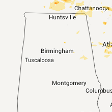


Connect with Interactive Hail Maps