| 9/4/2023 5:25 PM MDT |
Quarter sized hail reported 14 miles NNW of Broadus, MT
|
| 6/23/2023 4:00 PM MDT |
Half Dollar sized hail reported 24.6 miles NE of Broadus, MT
|
| 7/10/2022 7:31 PM MDT |
 At 731 pm mdt, a severe thunderstorm was located 24 miles southwest of broadus, moving east at 45 mph (radar indicated). Hazards include 60 mph wind gusts and quarter size hail. Hail damage to vehicles is expected. expect wind damage to roofs, siding, and trees. this severe thunderstorm will remain over mainly rural areas of southeastern powder river county, including the following locations, sonnette and belle creek. hail threat, radar indicated max hail size, 1. 00 in wind threat, radar indicated max wind gust, 60 mph. At 731 pm mdt, a severe thunderstorm was located 24 miles southwest of broadus, moving east at 45 mph (radar indicated). Hazards include 60 mph wind gusts and quarter size hail. Hail damage to vehicles is expected. expect wind damage to roofs, siding, and trees. this severe thunderstorm will remain over mainly rural areas of southeastern powder river county, including the following locations, sonnette and belle creek. hail threat, radar indicated max hail size, 1. 00 in wind threat, radar indicated max wind gust, 60 mph.
|
| 7/5/2022 6:27 AM MDT |
 At 626 am mdt, a severe thunderstorm was located 22 miles northeast of broadus, moving east at 25 mph (radar indicated). Hazards include quarter size hail. damage to vehicles is expected At 626 am mdt, a severe thunderstorm was located 22 miles northeast of broadus, moving east at 25 mph (radar indicated). Hazards include quarter size hail. damage to vehicles is expected
|
| 6/11/2022 6:35 PM MDT |
 At 635 pm mdt, a severe thunderstorm was located 7 miles northeast of broadus, moving southeast at 45 mph (radar indicated). Hazards include 60 mph wind gusts and quarter size hail. Hail damage to vehicles is expected. expect wind damage to roofs, siding, and trees. locations impacted include, broadus. hail threat, radar indicated max hail size, 1. 00 in wind threat, radar indicated max wind gust, 60 mph. At 635 pm mdt, a severe thunderstorm was located 7 miles northeast of broadus, moving southeast at 45 mph (radar indicated). Hazards include 60 mph wind gusts and quarter size hail. Hail damage to vehicles is expected. expect wind damage to roofs, siding, and trees. locations impacted include, broadus. hail threat, radar indicated max hail size, 1. 00 in wind threat, radar indicated max wind gust, 60 mph.
|
| 6/11/2022 6:25 PM MDT |
Storm damage reported in powder river county MT, 10 miles SE of Broadus, MT
|
| 6/11/2022 6:16 PM MDT |
Quarter sized hail reported 25.8 miles ENE of Broadus, MT
|
| 6/11/2022 6:12 PM MDT |
 At 612 pm mdt, a severe thunderstorm was located 13 miles south of volborg, or 18 miles northwest of broadus, moving east at 45 mph (radar indicated). Hazards include 60 mph wind gusts and quarter size hail. Hail damage to vehicles is expected. Expect wind damage to roofs, siding, and trees. At 612 pm mdt, a severe thunderstorm was located 13 miles south of volborg, or 18 miles northwest of broadus, moving east at 45 mph (radar indicated). Hazards include 60 mph wind gusts and quarter size hail. Hail damage to vehicles is expected. Expect wind damage to roofs, siding, and trees.
|
| 6/11/2022 5:45 PM MDT |
 At 543 pm mdt, a severe thunderstorm was located 14 miles south of ashland, or 37 miles southeast of colstrip, moving east southeast at 45 mph. the strongest portion of this storm is expected to remain south of us-212 (radar indicated). Hazards include ping pong ball size hail and 60 mph wind gusts, along with heavy rain. People and animals outdoors will be injured. expect hail damage to roofs, siding, windows, and vehicles. Expect wind damage to roofs, siding, and trees. At 543 pm mdt, a severe thunderstorm was located 14 miles south of ashland, or 37 miles southeast of colstrip, moving east southeast at 45 mph. the strongest portion of this storm is expected to remain south of us-212 (radar indicated). Hazards include ping pong ball size hail and 60 mph wind gusts, along with heavy rain. People and animals outdoors will be injured. expect hail damage to roofs, siding, windows, and vehicles. Expect wind damage to roofs, siding, and trees.
|
| 5/28/2021 8:00 PM MDT |
 At 759 pm mdt, a severe thunderstorm was located near broadus, moving east at 30 mph (trained weather spotters reported quarter size hail in broadus). Hazards include 60 mph wind gusts and quarter size hail, along with very heavy rainfall. Hail damage to vehicles is expected. expect wind damage to roofs, siding, and trees. Locations impacted include, broadus. At 759 pm mdt, a severe thunderstorm was located near broadus, moving east at 30 mph (trained weather spotters reported quarter size hail in broadus). Hazards include 60 mph wind gusts and quarter size hail, along with very heavy rainfall. Hail damage to vehicles is expected. expect wind damage to roofs, siding, and trees. Locations impacted include, broadus.
|
| 5/28/2021 7:50 PM MDT |
Quarter sized hail reported 0.2 miles NNE of Broadus, MT
|
| 5/28/2021 7:48 PM MDT |
Golf Ball sized hail reported 2.3 miles ESE of Broadus, MT
|
| 5/28/2021 7:48 PM MDT |
 At 747 pm mdt, a severe thunderstorm was located near broadus, moving east at 30 mph (radar indicated). Hazards include 60 mph wind gusts and half dollar size hail, along with very heavy rainfall. Hail damage to vehicles is expected. Expect wind damage to roofs, siding, and trees. At 747 pm mdt, a severe thunderstorm was located near broadus, moving east at 30 mph (radar indicated). Hazards include 60 mph wind gusts and half dollar size hail, along with very heavy rainfall. Hail damage to vehicles is expected. Expect wind damage to roofs, siding, and trees.
|
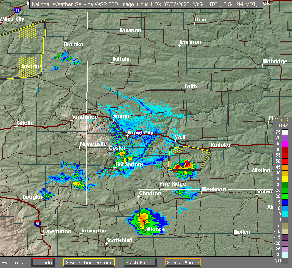
| 7/7/2020 7:02 PM MDT |
Ping Pong Ball sized hail reported 18.6 miles WNW of Broadus, MT
|
| 7/7/2020 6:42 PM MDT |
 At 641 pm mdt, severe thunderstorms were located along a line extending from 35 miles northwest of ekalaka to 11 miles southeast of broadus, moving east at 30 mph. the southern portion of these storms contains good rotation (trained weather spotters. at 610 pm mdt, ping pong size hail was reported 10 miles west of broadus). Hazards include ping pong ball size hail and 60 mph wind gusts. People and animals outdoors will be injured. expect hail damage to roofs, siding, windows, and vehicles. Expect wind damage to roofs, siding, and trees. At 641 pm mdt, severe thunderstorms were located along a line extending from 35 miles northwest of ekalaka to 11 miles southeast of broadus, moving east at 30 mph. the southern portion of these storms contains good rotation (trained weather spotters. at 610 pm mdt, ping pong size hail was reported 10 miles west of broadus). Hazards include ping pong ball size hail and 60 mph wind gusts. People and animals outdoors will be injured. expect hail damage to roofs, siding, windows, and vehicles. Expect wind damage to roofs, siding, and trees.
|
| 7/7/2020 6:35 PM MDT |
Ping Pong Ball sized hail reported 4 miles SW of Broadus, MT
|
| 7/7/2020 6:30 PM MDT |
Quarter sized hail reported 14 miles NNW of Broadus, MT
|
| 7/7/2020 6:27 PM MDT |
Golf Ball sized hail reported 2.3 miles ESE of Broadus, MT
|
| 7/7/2020 6:05 PM MDT |
Quarter sized hail reported 10.7 miles E of Broadus, MT
|
| 7/7/2020 5:56 PM MDT |
 At 556 pm mdt, severe thunderstorms were located along a line extending from 13 miles north of volborg to 15 miles west of broadus, moving east at 45 mph (trained weather spotters. this storm has a history of producing quarter size hail). Hazards include 60 mph wind gusts and quarter size hail. Hail damage to vehicles is expected. expect wind damage to roofs, siding, and trees. Locations impacted include, broadus, volborg, olive, sonnette, powderville, garland, mizpah and knowlton. At 556 pm mdt, severe thunderstorms were located along a line extending from 13 miles north of volborg to 15 miles west of broadus, moving east at 45 mph (trained weather spotters. this storm has a history of producing quarter size hail). Hazards include 60 mph wind gusts and quarter size hail. Hail damage to vehicles is expected. expect wind damage to roofs, siding, and trees. Locations impacted include, broadus, volborg, olive, sonnette, powderville, garland, mizpah and knowlton.
|
| 7/7/2020 5:43 PM MDT |
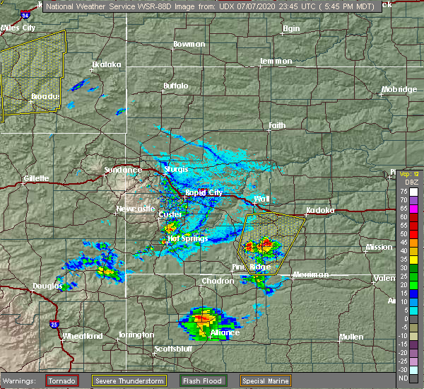 At 543 pm mdt, severe thunderstorms were located along a line extending from 15 miles northwest of volborg to 23 miles west of broadus, moving east at 45 mph (trained weather spotters. this storm has a history of producing quarter size hail). Hazards include 60 mph wind gusts and quarter size hail. Hail damage to vehicles is expected. Expect wind damage to roofs, siding, and trees. At 543 pm mdt, severe thunderstorms were located along a line extending from 15 miles northwest of volborg to 23 miles west of broadus, moving east at 45 mph (trained weather spotters. this storm has a history of producing quarter size hail). Hazards include 60 mph wind gusts and quarter size hail. Hail damage to vehicles is expected. Expect wind damage to roofs, siding, and trees.
|
| 7/6/2020 4:25 PM MDT |
Golf Ball sized hail reported 28 miles NE of Broadus, MT
|
| 7/4/2020 7:53 PM MDT |
 The severe thunderstorm warning for eastern powder river county will expire at 800 pm mdt, the storm which prompted the warning has weakened below severe limits, and no longer poses an immediate threat to life or property. therefore, the warning will be allowed to expire. a severe thunderstorm watch remains in effect until midnight mdt for southeastern montana. The severe thunderstorm warning for eastern powder river county will expire at 800 pm mdt, the storm which prompted the warning has weakened below severe limits, and no longer poses an immediate threat to life or property. therefore, the warning will be allowed to expire. a severe thunderstorm watch remains in effect until midnight mdt for southeastern montana.
|
| 7/4/2020 7:42 PM MDT |
 At 741 pm mdt, a severe thunderstorm was located near broadus, moving east at 35 mph (radar indicated). Hazards include 60 mph wind gusts and quarter size hail. Hail damage to vehicles is expected. expect wind damage to roofs, siding, and trees. Locations impacted include, broadus, biddle, olive and belle creek. At 741 pm mdt, a severe thunderstorm was located near broadus, moving east at 35 mph (radar indicated). Hazards include 60 mph wind gusts and quarter size hail. Hail damage to vehicles is expected. expect wind damage to roofs, siding, and trees. Locations impacted include, broadus, biddle, olive and belle creek.
|
| 7/4/2020 7:13 PM MDT |
 At 713 pm mdt, a severe thunderstorm was located 16 miles west of broadus, moving east at 35 mph (radar indicated). Hazards include 60 mph wind gusts and quarter size hail. Hail damage to vehicles is expected. Expect wind damage to roofs, siding, and trees. At 713 pm mdt, a severe thunderstorm was located 16 miles west of broadus, moving east at 35 mph (radar indicated). Hazards include 60 mph wind gusts and quarter size hail. Hail damage to vehicles is expected. Expect wind damage to roofs, siding, and trees.
|
|
|
| 7/3/2020 5:45 PM MDT |
Quarter sized hail reported 14 miles NNW of Broadus, MT
|
| 6/4/2020 3:40 PM MDT |
Quarter sized hail reported 14 miles NNW of Broadus, MT
|
| 5/20/2020 6:00 PM MDT |
6 inch tree limbs downed damage to out building in powder river county MT, 14 miles NNW of Broadus, MT
|
| 9/10/2019 8:26 PM MDT |
 At 826 pm mdt, a severe thunderstorm was located 17 miles southeast of ashland, or 26 miles west of broadus, and is nearly stationary (radar indicated). Hazards include 60 mph wind gusts and quarter size hail. Hail damage to vehicles is expected. expect wind damage to roofs, siding, and trees. Locations impacted include, broadus, olive and sonnette. At 826 pm mdt, a severe thunderstorm was located 17 miles southeast of ashland, or 26 miles west of broadus, and is nearly stationary (radar indicated). Hazards include 60 mph wind gusts and quarter size hail. Hail damage to vehicles is expected. expect wind damage to roofs, siding, and trees. Locations impacted include, broadus, olive and sonnette.
|
| 9/10/2019 8:03 PM MDT |
 At 803 pm mdt, a severe thunderstorm was located 21 miles west of broadus, moving east at 30 mph (radar indicated). Hazards include 60 mph wind gusts and quarter size hail. Hail damage to vehicles is expected. Expect wind damage to roofs, siding, and trees. At 803 pm mdt, a severe thunderstorm was located 21 miles west of broadus, moving east at 30 mph (radar indicated). Hazards include 60 mph wind gusts and quarter size hail. Hail damage to vehicles is expected. Expect wind damage to roofs, siding, and trees.
|
| 8/14/2019 7:50 PM MDT |
Half Dollar sized hail reported 18.6 miles WNW of Broadus, MT, half dollar-sized hail.
|
| 7/16/2019 6:57 PM MDT |
 At 624 pm mdt, a severe thunderstorm was located 12 miles northwest of biddle, or 17 miles south of broadus, moving east at 40 mph. an additional severe thunderstorm is located 8 miles northwest of broadus moving northeast at 25 mph (trained weather spotters). Hazards include golf ball size hail and 60 mph wind gusts. golf ball hail was reported 9.5 miles ne of moorhead. People and animals outdoors will be injured. expect hail damage to roofs, siding, windows, and vehicles. Expect wind damage to roofs, siding, and trees. At 624 pm mdt, a severe thunderstorm was located 12 miles northwest of biddle, or 17 miles south of broadus, moving east at 40 mph. an additional severe thunderstorm is located 8 miles northwest of broadus moving northeast at 25 mph (trained weather spotters). Hazards include golf ball size hail and 60 mph wind gusts. golf ball hail was reported 9.5 miles ne of moorhead. People and animals outdoors will be injured. expect hail damage to roofs, siding, windows, and vehicles. Expect wind damage to roofs, siding, and trees.
|
| 7/16/2019 6:26 PM MDT |
 At 624 pm mdt, a severe thunderstorm was located 12 miles northwest of biddle, or 17 miles south of broadus, moving east at 40 mph. an additional severe thunderstorm is located 8 miles northwest of broadus moving northeast at 25 mph (trained weather spotters). Hazards include golf ball size hail and 60 mph wind gusts. golf ball hail was reported 9.5 miles ne of moorhead. People and animals outdoors will be injured. expect hail damage to roofs, siding, windows, and vehicles. Expect wind damage to roofs, siding, and trees. At 624 pm mdt, a severe thunderstorm was located 12 miles northwest of biddle, or 17 miles south of broadus, moving east at 40 mph. an additional severe thunderstorm is located 8 miles northwest of broadus moving northeast at 25 mph (trained weather spotters). Hazards include golf ball size hail and 60 mph wind gusts. golf ball hail was reported 9.5 miles ne of moorhead. People and animals outdoors will be injured. expect hail damage to roofs, siding, windows, and vehicles. Expect wind damage to roofs, siding, and trees.
|
| 7/16/2019 6:15 PM MDT |
Golf Ball sized hail reported 24.6 miles NE of Broadus, MT
|
| 7/15/2019 2:09 AM MDT |
 At 208 am mdt, a severe thunderstorm was located near broadus, moving northeast at 35 mph (radar indicated). Hazards include 60 mph wind gusts and half dollar size hail. Hail damage to vehicles is expected. expect wind damage to roofs, siding, and trees. Locations impacted include, broadus. At 208 am mdt, a severe thunderstorm was located near broadus, moving northeast at 35 mph (radar indicated). Hazards include 60 mph wind gusts and half dollar size hail. Hail damage to vehicles is expected. expect wind damage to roofs, siding, and trees. Locations impacted include, broadus.
|
| 7/15/2019 2:00 AM MDT |
Quarter sized hail reported 0.2 miles NNE of Broadus, MT, hail persisted for about 10 minutes until 210 am.
|
| 7/15/2019 1:43 AM MDT |
 At 143 am mdt, a severe thunderstorm was located near broadus, moving northeast at 40 mph (radar indicated). Hazards include 60 mph wind gusts and half dollar size hail. Hail damage to vehicles is expected. Expect wind damage to roofs, siding, and trees. At 143 am mdt, a severe thunderstorm was located near broadus, moving northeast at 40 mph (radar indicated). Hazards include 60 mph wind gusts and half dollar size hail. Hail damage to vehicles is expected. Expect wind damage to roofs, siding, and trees.
|
| 7/15/2019 12:58 AM MDT |
 The severe thunderstorm warning for northeastern powder river county will expire at 100 am mdt, the storms which prompted the warning have weakened below severe limits, and no longer poses an immediate threat to life or property. therefore, the warning will be allowed to expire. however scattered storms continue to form over the county and small hail is still likely with any of these thunderstorms. The severe thunderstorm warning for northeastern powder river county will expire at 100 am mdt, the storms which prompted the warning have weakened below severe limits, and no longer poses an immediate threat to life or property. therefore, the warning will be allowed to expire. however scattered storms continue to form over the county and small hail is still likely with any of these thunderstorms.
|
| 7/15/2019 12:46 AM MDT |
 At 1245 am mdt, another severe thunderstorm has developed and was located 11 miles west of broadus, moving east at 25 mph (radar indicated). Hazards include 60 mph wind gusts and quarter size hail. Hail damage to vehicles is expected. expect wind damage to roofs, siding, and trees. Locations impacted include, broadus and olive. At 1245 am mdt, another severe thunderstorm has developed and was located 11 miles west of broadus, moving east at 25 mph (radar indicated). Hazards include 60 mph wind gusts and quarter size hail. Hail damage to vehicles is expected. expect wind damage to roofs, siding, and trees. Locations impacted include, broadus and olive.
|
| 7/15/2019 12:33 AM MDT |
 At 1231 am mdt, a severe thunderstorm was located near broadus, moving east at 35 mph. however, additional storms were rapidly developing behind this storm in the warned area (radar indicated). Hazards include 60 mph wind gusts and quarter size hail. Hail damage to vehicles is expected. expect wind damage to roofs, siding, and trees. Locations impacted include, broadus and olive. At 1231 am mdt, a severe thunderstorm was located near broadus, moving east at 35 mph. however, additional storms were rapidly developing behind this storm in the warned area (radar indicated). Hazards include 60 mph wind gusts and quarter size hail. Hail damage to vehicles is expected. expect wind damage to roofs, siding, and trees. Locations impacted include, broadus and olive.
|
| 7/15/2019 12:02 AM MDT |
 At 1201 am mdt, a severe thunderstorm was located 10 miles west of broadus, moving east at 40 mph (trained weather spotters). Hazards include quarter size hail was reported at midnight by trained spotters. damage to vehicles is expected At 1201 am mdt, a severe thunderstorm was located 10 miles west of broadus, moving east at 40 mph (trained weather spotters). Hazards include quarter size hail was reported at midnight by trained spotters. damage to vehicles is expected
|
| 7/15/2019 12:00 AM MDT |
Quarter sized hail reported 10.7 miles E of Broadus, MT
|
| 7/8/2019 9:03 PM MDT |
Quarter sized hail reported 18.6 miles WNW of Broadus, MT
|
| 7/2/2019 2:43 PM MDT |
 At 242 pm mdt, severe thunderstorms were located along a line extending from 11 miles west of broadus to 13 miles north of recluse, moving east at 30 mph (radar indicated). Hazards include 60 mph wind gusts and quarter size hail. Hail damage to vehicles is expected. Expect wind damage to roofs, siding, and trees. At 242 pm mdt, severe thunderstorms were located along a line extending from 11 miles west of broadus to 13 miles north of recluse, moving east at 30 mph (radar indicated). Hazards include 60 mph wind gusts and quarter size hail. Hail damage to vehicles is expected. Expect wind damage to roofs, siding, and trees.
|
| 6/30/2019 7:42 PM MDT |
 The severe thunderstorm warning for east central powder river county will expire at 745 pm mdt, the storm which prompted the warning has weakened below severe limits, and no longer poses an immediate threat to life or property. therefore, the warning will be allowed to expire. however small hail, gusty winds and heavy rain are still possible with this thunderstorm. The severe thunderstorm warning for east central powder river county will expire at 745 pm mdt, the storm which prompted the warning has weakened below severe limits, and no longer poses an immediate threat to life or property. therefore, the warning will be allowed to expire. however small hail, gusty winds and heavy rain are still possible with this thunderstorm.
|
| 6/30/2019 7:30 PM MDT |
Quarter sized hail reported 8.5 miles N of Broadus, MT
|
| 6/30/2019 7:13 PM MDT |
 At 712 pm mdt, a severe thunderstorm was located 11 miles southwest of broadus, moving east at 25 mph (radar indicated). Hazards include 60 mph wind gusts and quarter size hail. Hail damage to vehicles is expected. expect wind damage to roofs, siding, and trees. Locations impacted include, broadus. At 712 pm mdt, a severe thunderstorm was located 11 miles southwest of broadus, moving east at 25 mph (radar indicated). Hazards include 60 mph wind gusts and quarter size hail. Hail damage to vehicles is expected. expect wind damage to roofs, siding, and trees. Locations impacted include, broadus.
|
| 6/30/2019 6:51 PM MDT |
 At 650 pm mdt, a severe thunderstorm was located 18 miles west of broadus, moving east at 25 mph (radar indicated). Hazards include 60 mph wind gusts and quarter size hail. Hail damage to vehicles is expected. Expect wind damage to roofs, siding, and trees. At 650 pm mdt, a severe thunderstorm was located 18 miles west of broadus, moving east at 25 mph (radar indicated). Hazards include 60 mph wind gusts and quarter size hail. Hail damage to vehicles is expected. Expect wind damage to roofs, siding, and trees.
|
| 6/26/2019 9:05 PM MDT |
Winds almost pushed car off of highway 212. torrential rainfall. tree limbs in roa in powder river county MT, 13.6 miles NW of Broadus, MT
|
| 6/26/2019 9:05 PM MDT |
Winds almost pushed car off of highway 212. torrential rainfall. tree limbs in roa in powder river county MT, 13.6 miles NW of Broadus, MT
|
|
|
| 6/26/2019 7:42 PM MDT |
Baseball sized hail reported 24.6 miles NE of Broadus, MT, baseball plus size hail
|
| 6/26/2019 7:00 PM MDT |
Golf Ball sized hail reported 34.4 miles ENE of Broadus, MT, had golf ball hail at 700 pm lasting around 15 mph plus 60 mph winds on wind gauge.
|
| 6/26/2019 7:00 PM MDT |
Had golf ball hail at 700 pm lasting around 15 mph plus 60 mph winds on wind gaug in powder river county MT, 34.4 miles ENE of Broadus, MT
|
| 6/7/2019 5:25 PM MDT |
Golf Ball sized hail reported 12.5 miles NNW of Broadus, MT, dimes to golf ball sized hail. estimated 30 mph winds.
|
| 6/7/2019 5:24 PM MDT |
Half Dollar sized hail reported 11.7 miles NNW of Broadus, MT, highway 59 mm18
|
| 8/3/2018 8:31 PM MDT |
 At 827 pm mdt, a line of severe winds associated with thunderstorms was located along a line extending from 11 miles west of baker to near ekalaka and alzada, moving east at 45 mph (radar indicated). Hazards include 60 mph wind gusts. Expect damage to roofs, siding, and trees. Locations impacted include, baker, broadus, ekalaka, ridgeway, biddle, alzada, plevna, ismay, locate, westmore, boyes, mill iron, medicine rocks state park, capitol, knowlton, ollie, willard, webster, hammond and belltower. At 827 pm mdt, a line of severe winds associated with thunderstorms was located along a line extending from 11 miles west of baker to near ekalaka and alzada, moving east at 45 mph (radar indicated). Hazards include 60 mph wind gusts. Expect damage to roofs, siding, and trees. Locations impacted include, baker, broadus, ekalaka, ridgeway, biddle, alzada, plevna, ismay, locate, westmore, boyes, mill iron, medicine rocks state park, capitol, knowlton, ollie, willard, webster, hammond and belltower.
|
| 8/3/2018 7:28 PM MDT |
 At 725 pm mdt, a line of severe winds associated with thunderstorms was located from 10 miles east of miles city south to the wyoming border, moving east at 45 mph (radar indicated). Hazards include 60 mph wind gusts. expect damage to roofs, siding, and trees At 725 pm mdt, a line of severe winds associated with thunderstorms was located from 10 miles east of miles city south to the wyoming border, moving east at 45 mph (radar indicated). Hazards include 60 mph wind gusts. expect damage to roofs, siding, and trees
|
| 8/3/2018 7:12 PM MDT |
Limbs 2 inches in diameter snapped from strong wind in powder river county MT, 0.2 miles NNE of Broadus, MT
|
| 8/3/2018 7:02 PM MDT |
 A severe thunderstorm warning remains in effect until 730 pm mdt for southeastern fallon. southeastern big horn. southern custer. carter. powder river and southern rosebud counties. At 701 pm mdt, severe thunderstorms were located along a line extending from 28 miles northwest of ekalaka to 10 miles southeast of volborg to 19 miles west of broadus, moving east at 55 mph. A severe thunderstorm warning remains in effect until 730 pm mdt for southeastern fallon. southeastern big horn. southern custer. carter. powder river and southern rosebud counties. At 701 pm mdt, severe thunderstorms were located along a line extending from 28 miles northwest of ekalaka to 10 miles southeast of volborg to 19 miles west of broadus, moving east at 55 mph.
|
| 8/3/2018 6:28 PM MDT |
 At 627 pm mdt, severe thunderstorms were located along a line extending from 13 miles north of volborg to 9 miles northeast of ashland to 29 miles southeast of lame deer, moving east at 55 mph (radar indicated). Hazards include 60 mph wind gusts. expect damage to roofs, siding, and trees At 627 pm mdt, severe thunderstorms were located along a line extending from 13 miles north of volborg to 9 miles northeast of ashland to 29 miles southeast of lame deer, moving east at 55 mph (radar indicated). Hazards include 60 mph wind gusts. expect damage to roofs, siding, and trees
|
| 6/28/2018 11:04 PM MDT |
 At 1103 pm mdt, a severe thunderstorm was located 7 miles south of broadus, moving east at 35 mph (radar indicated). Hazards include 60 mph wind gusts and quarter size hail. Hail damage to vehicles is possible along with wind damage to roofs and trees. Locations impacted include, broadus and biddle. At 1103 pm mdt, a severe thunderstorm was located 7 miles south of broadus, moving east at 35 mph (radar indicated). Hazards include 60 mph wind gusts and quarter size hail. Hail damage to vehicles is possible along with wind damage to roofs and trees. Locations impacted include, broadus and biddle.
|
| 6/28/2018 10:41 PM MDT |
 At 1040 pm mdt, a severe thunderstorm was located 23 miles west of biddle, or 24 miles southwest of broadus, moving east at 35 mph (radar indicated). Hazards include 60 mph wind gusts and quarter size hail. Hail damage to vehicles is possible. Expect wind damage to roofs, siding, and trees. At 1040 pm mdt, a severe thunderstorm was located 23 miles west of biddle, or 24 miles southwest of broadus, moving east at 35 mph (radar indicated). Hazards include 60 mph wind gusts and quarter size hail. Hail damage to vehicles is possible. Expect wind damage to roofs, siding, and trees.
|
| 6/28/2018 9:00 PM MDT |
Hen Egg sized hail reported 4 miles SW of Broadus, MT
|
| 6/28/2018 8:46 PM MDT |
 At 843 pm mdt, a severe thunderstorm was located 8 miles northwest of broadus, near olive, moving east at 40 mph (radar indicated). Hazards include golf ball size hail and 60 mph wind gusts, along with very heavy rain. People and animals outdoors will be injured. expect hail damage to roofs, siding, windows, and vehicles. expect wind damage to roofs, siding, and trees. localized flooding is possible due to the heavy rainfall. locations impacted include, broadus and olive. spotters reported hail up to golf ball size with this storm near epsie. A tornado watch remains in effect until 1100 pm mdt for southeastern montana. At 843 pm mdt, a severe thunderstorm was located 8 miles northwest of broadus, near olive, moving east at 40 mph (radar indicated). Hazards include golf ball size hail and 60 mph wind gusts, along with very heavy rain. People and animals outdoors will be injured. expect hail damage to roofs, siding, windows, and vehicles. expect wind damage to roofs, siding, and trees. localized flooding is possible due to the heavy rainfall. locations impacted include, broadus and olive. spotters reported hail up to golf ball size with this storm near epsie. A tornado watch remains in effect until 1100 pm mdt for southeastern montana.
|
| 6/28/2018 8:42 PM MDT |
Half Dollar sized hail reported 12.2 miles ESE of Broadus, MT
|
| 6/28/2018 8:35 PM MDT |
Tennis Ball sized hail reported 12.2 miles ESE of Broadus, MT
|
| 6/28/2018 8:33 PM MDT |
Golf Ball sized hail reported 10.7 miles E of Broadus, MT
|
| 6/28/2018 8:29 PM MDT |
 At 828 pm mdt, a severe thunderstorm was located 20 miles west of broadus, moving east at 40 mph (radar indicated). Hazards include tennis ball size hail and 70 mph wind gusts, along with very heavy rain. People and animals outdoors will be injured. expect hail damage to roofs, siding, windows, and vehicles. expect considerable tree damage. Wind damage is also likely to mobile homes, roofs, and outbuildings. At 828 pm mdt, a severe thunderstorm was located 20 miles west of broadus, moving east at 40 mph (radar indicated). Hazards include tennis ball size hail and 70 mph wind gusts, along with very heavy rain. People and animals outdoors will be injured. expect hail damage to roofs, siding, windows, and vehicles. expect considerable tree damage. Wind damage is also likely to mobile homes, roofs, and outbuildings.
|
| 6/28/2018 5:41 PM MDT |
 At 541 pm mdt, a severe thunderstorm was located 15 miles southeast of broadus, moving east at 30 mph (trained weather spotters). Hazards include 60 mph wind gusts and half dollar size hail. Hail damage to vehicles is expected. expect wind damage to roofs, siding, and trees. locations impacted include, broadus, boyes and hammond. A tornado watch remains in effect until 1100 pm mdt for southeastern montana. At 541 pm mdt, a severe thunderstorm was located 15 miles southeast of broadus, moving east at 30 mph (trained weather spotters). Hazards include 60 mph wind gusts and half dollar size hail. Hail damage to vehicles is expected. expect wind damage to roofs, siding, and trees. locations impacted include, broadus, boyes and hammond. A tornado watch remains in effect until 1100 pm mdt for southeastern montana.
|
| 6/28/2018 5:13 PM MDT |
 At 512 pm mdt, a severe thunderstorm was located 11 miles north of biddle, or 12 miles south of broadus, moving east at 30 mph (trained weather spotters. at 502 pm spotters reported quarter sized hail 13 miles west of broadus). Hazards include 60 mph wind gusts and half dollar size hail. Hail damage to vehicles is expected. Expect wind damage to roofs, siding, and trees. At 512 pm mdt, a severe thunderstorm was located 11 miles north of biddle, or 12 miles south of broadus, moving east at 30 mph (trained weather spotters. at 502 pm spotters reported quarter sized hail 13 miles west of broadus). Hazards include 60 mph wind gusts and half dollar size hail. Hail damage to vehicles is expected. Expect wind damage to roofs, siding, and trees.
|
| 6/28/2018 5:03 PM MDT |
Quarter sized hail reported 11.9 miles E of Broadus, MT
|
| 6/28/2018 4:42 PM MDT |
 At 441 pm mdt, a severe thunderstorm was located 17 miles southwest of broadus, moving north at 25 mph (radar indicated). Hazards include 60 mph wind gusts and half dollar size hail. Hail damage to vehicles is expected. expect wind damage to roofs, siding, and trees. locations impacted include, broadus, biddle, olive, sonnette and belle creek. A tornado watch remains in effect until 1100 pm mdt for southeastern montana. At 441 pm mdt, a severe thunderstorm was located 17 miles southwest of broadus, moving north at 25 mph (radar indicated). Hazards include 60 mph wind gusts and half dollar size hail. Hail damage to vehicles is expected. expect wind damage to roofs, siding, and trees. locations impacted include, broadus, biddle, olive, sonnette and belle creek. A tornado watch remains in effect until 1100 pm mdt for southeastern montana.
|
| 6/28/2018 4:09 PM MDT |
 The national weather service in billings has issued a * severe thunderstorm warning for. powder river county in southeastern montana. until 515 pm mdt. At 408 pm mdt, severe thunderstorms were located along a line extending from 25 miles north of spotted horse to 16 miles west of. The national weather service in billings has issued a * severe thunderstorm warning for. powder river county in southeastern montana. until 515 pm mdt. At 408 pm mdt, severe thunderstorms were located along a line extending from 25 miles north of spotted horse to 16 miles west of.
|
| 6/9/2018 5:45 PM MDT |
Quarter sized hail reported 10.7 miles E of Broadus, MT
|
| 6/9/2018 5:45 PM MDT |
 At 544 pm mdt, a severe thunderstorm was located 13 miles west of broadus, moving north northeast at 15 mph (trained weather spotters). Hazards include ping pong ball size hail and 60 mph wind gusts. People and animals outdoors will be injured. expect hail damage to roofs, siding, windows, and vehicles. expect wind damage to roofs, siding, and trees. Locations impacted include, broadus and olive. At 544 pm mdt, a severe thunderstorm was located 13 miles west of broadus, moving north northeast at 15 mph (trained weather spotters). Hazards include ping pong ball size hail and 60 mph wind gusts. People and animals outdoors will be injured. expect hail damage to roofs, siding, windows, and vehicles. expect wind damage to roofs, siding, and trees. Locations impacted include, broadus and olive.
|
|
|
| 6/9/2018 5:40 PM MDT |
Ping Pong Ball sized hail reported 12.2 miles ESE of Broadus, MT
|
| 6/9/2018 5:27 PM MDT |
 At 527 pm mdt, a severe thunderstorm was located 11 miles west of broadus, moving northeast at 15 mph (radar indicated). Hazards include 60 mph wind gusts and quarter size hail. Hail damage to vehicles is expected. Expect wind damage to roofs, siding, and trees. At 527 pm mdt, a severe thunderstorm was located 11 miles west of broadus, moving northeast at 15 mph (radar indicated). Hazards include 60 mph wind gusts and quarter size hail. Hail damage to vehicles is expected. Expect wind damage to roofs, siding, and trees.
|
| 8/1/2017 4:30 PM MDT |
Quarter sized hail reported 10.7 miles E of Broadus, MT
|
| 8/1/2017 4:30 PM MDT |
 At 430 pm mdt, a severe thunderstorm was located 7 miles west of broadus, moving east at 10 mph (radar indicated). Hazards include 60 mph wind gusts and quarter size hail. Hail damage to vehicles is expected. Expect wind damage to roofs, siding, and trees. At 430 pm mdt, a severe thunderstorm was located 7 miles west of broadus, moving east at 10 mph (radar indicated). Hazards include 60 mph wind gusts and quarter size hail. Hail damage to vehicles is expected. Expect wind damage to roofs, siding, and trees.
|
| 5/15/2017 5:15 PM MDT |
Quarter sized hail reported 18.7 miles SSE of Broadus, MT, minor tree leaf damage. 1 of rain in 15-20 minutes
|
| 8/9/2016 5:00 PM MDT |
Ping Pong Ball sized hail reported 0.2 miles NNE of Broadus, MT
|
| 8/9/2016 4:58 PM MDT |
 At 457 pm mdt, a severe thunderstorm was located near broadus, moving east at 25 mph (radar indicated). Hazards include 60 mph wind gusts and half dollar size hail. Hail damage to vehicles is expected. Expect wind damage to roofs, siding, and trees. At 457 pm mdt, a severe thunderstorm was located near broadus, moving east at 25 mph (radar indicated). Hazards include 60 mph wind gusts and half dollar size hail. Hail damage to vehicles is expected. Expect wind damage to roofs, siding, and trees.
|
| 8/9/2016 4:50 PM MDT |
Quarter sized hail reported 3.4 miles W of Broadus, MT
|
| 8/9/2016 4:45 PM MDT |
Golf Ball sized hail reported 0.2 miles NNE of Broadus, MT
|
| 8/9/2016 4:39 PM MDT |
Quarter sized hail reported 10.7 miles E of Broadus, MT
|
| 8/9/2016 4:38 PM MDT |
 At 436 pm mdt, a severe thunderstorm was located 7 miles west of broadus, moving northeast at 30 mph (radar indicated). Hazards include 60 mph wind gusts and quarter size hail. Hail damage to vehicles is expected. expect wind damage to roofs, siding, and trees. Locations impacted include, broadus, powderville and olive. At 436 pm mdt, a severe thunderstorm was located 7 miles west of broadus, moving northeast at 30 mph (radar indicated). Hazards include 60 mph wind gusts and quarter size hail. Hail damage to vehicles is expected. expect wind damage to roofs, siding, and trees. Locations impacted include, broadus, powderville and olive.
|
| 8/9/2016 4:08 PM MDT |
 At 407 pm mdt, a severe thunderstorm was located 14 miles west of broadus, moving northeast at 30 mph (radar indicated). Hazards include 60 mph wind gusts and half dollar size hail. Hail damage to vehicles is expected. Expect wind damage to roofs, siding, and trees. At 407 pm mdt, a severe thunderstorm was located 14 miles west of broadus, moving northeast at 30 mph (radar indicated). Hazards include 60 mph wind gusts and half dollar size hail. Hail damage to vehicles is expected. Expect wind damage to roofs, siding, and trees.
|
| 8/1/2016 12:20 AM MDT |
 At 1219 am mdt, a severe thunderstorm was located 14 miles southwest of broadus, moving northeast at 25 mph (radar indicated). Hazards include 60 mph wind gusts and half dollar size hail. Hail damage to vehicles is expected. Expect wind damage to roofs, siding, and trees. At 1219 am mdt, a severe thunderstorm was located 14 miles southwest of broadus, moving northeast at 25 mph (radar indicated). Hazards include 60 mph wind gusts and half dollar size hail. Hail damage to vehicles is expected. Expect wind damage to roofs, siding, and trees.
|
| 7/27/2016 9:43 PM MDT |
 At 942 pm mdt, a severe thunderstorm was located near broadus, moving south at 40 mph (radar indicated). Hazards include golf ball size hail and 60 mph wind gusts. People and animals outdoors will be injured. expect hail damage to roofs, siding, windows, and vehicles. Expect wind damage to roofs, siding, and trees. At 942 pm mdt, a severe thunderstorm was located near broadus, moving south at 40 mph (radar indicated). Hazards include golf ball size hail and 60 mph wind gusts. People and animals outdoors will be injured. expect hail damage to roofs, siding, windows, and vehicles. Expect wind damage to roofs, siding, and trees.
|
| 7/27/2016 8:49 PM MDT |
 At 849 pm mdt, a severe thunderstorm was located 11 miles northwest of broadus, moving southeast at 40 mph (radar indicated). Hazards include golf ball size hail and 60 mph wind gusts. People and animals outdoors will be injured. expect hail damage to roofs, siding, windows, and vehicles. expect wind damage to roofs, siding, and trees. Locations impacted include, broadus, sonnette and olive. At 849 pm mdt, a severe thunderstorm was located 11 miles northwest of broadus, moving southeast at 40 mph (radar indicated). Hazards include golf ball size hail and 60 mph wind gusts. People and animals outdoors will be injured. expect hail damage to roofs, siding, windows, and vehicles. expect wind damage to roofs, siding, and trees. Locations impacted include, broadus, sonnette and olive.
|
| 7/27/2016 8:42 PM MDT |
 At 840 pm mdt, a severe thunderstorm was located 17 miles south of volborg, or 17 miles northwest of broadus, moving southeast at 40 mph (radar indicated). Hazards include this storm has a history of producing golf ball size hail and 60 mph wind gusts. People and animals outdoors will be injured. expect hail damage to roofs, siding, windows, and vehicles. expect wind damage to roofs, siding, and trees. Locations impacted include, broadus, sonnette and olive. At 840 pm mdt, a severe thunderstorm was located 17 miles south of volborg, or 17 miles northwest of broadus, moving southeast at 40 mph (radar indicated). Hazards include this storm has a history of producing golf ball size hail and 60 mph wind gusts. People and animals outdoors will be injured. expect hail damage to roofs, siding, windows, and vehicles. expect wind damage to roofs, siding, and trees. Locations impacted include, broadus, sonnette and olive.
|
| 7/27/2016 8:21 PM MDT |
 At 819 pm mdt, a severe thunderstorm was located 16 miles northeast of ashland, or 31 miles northwest of broadus, moving southeast at 40 mph (radar indicated). Hazards include two inch hail and 60 mph wind gusts. People and animals outdoors will be injured. expect hail damage to roofs, siding, windows, and vehicles. Expect wind damage to roofs, siding, and trees. At 819 pm mdt, a severe thunderstorm was located 16 miles northeast of ashland, or 31 miles northwest of broadus, moving southeast at 40 mph (radar indicated). Hazards include two inch hail and 60 mph wind gusts. People and animals outdoors will be injured. expect hail damage to roofs, siding, windows, and vehicles. Expect wind damage to roofs, siding, and trees.
|
| 7/18/2016 6:25 PM MDT |
Quarter sized hail reported 18.6 miles WNW of Broadus, MT
|
| 7/16/2016 3:24 PM MDT |
 At 324 pm mdt, a severe thunderstorm was located 27 miles southwest of broadus, moving east at 35 mph (radar indicated). Hazards include 60 mph wind gusts and quarter size hail. Hail damage to vehicles is expected. Expect wind damage to roofs, siding, and trees. At 324 pm mdt, a severe thunderstorm was located 27 miles southwest of broadus, moving east at 35 mph (radar indicated). Hazards include 60 mph wind gusts and quarter size hail. Hail damage to vehicles is expected. Expect wind damage to roofs, siding, and trees.
|
| 6/11/2016 7:01 PM MDT |
 At 701 pm mdt, a severe thunderstorm was located 8 miles west of broadus, moving north at 25 mph (radar indicated). Hazards include 60 mph wind gusts and quarter size hail. Hail damage to vehicles is expected. Expect wind damage to roofs, siding, and trees. At 701 pm mdt, a severe thunderstorm was located 8 miles west of broadus, moving north at 25 mph (radar indicated). Hazards include 60 mph wind gusts and quarter size hail. Hail damage to vehicles is expected. Expect wind damage to roofs, siding, and trees.
|
| 6/11/2016 6:44 PM MDT |
Trained spotter estimates winds of 65 mph or greater. snowmobile trailer flipped over. pea size hai in powder river county MT, 35.2 miles NNE of Broadus, MT
|
| 6/11/2016 4:34 PM MDT |
3 to 4 inch diameter tree branches broken off. hail up to the size of marbles. winds estimated around 60 mp in powder river county MT, 18.7 miles SSE of Broadus, MT
|
| 6/9/2016 7:20 PM MDT |
Storm damage reported in powder river county MT, 20.4 miles SSW of Broadus, MT
|
| 9/5/2015 8:37 PM MDT |
Hen Egg sized hail reported 4 miles SW of Broadus, MT
|
| 9/5/2015 8:36 PM MDT |
Tennis Ball sized hail reported 0.2 miles NNE of Broadus, MT
|
|
|
| 9/5/2015 8:32 PM MDT |
Ping Pong Ball sized hail reported 0.2 miles NNE of Broadus, MT
|
| 9/5/2015 8:28 PM MDT |
Golf Ball sized hail reported 2.3 miles ESE of Broadus, MT
|
| 9/5/2015 8:25 PM MDT |
 At 823 pm mdt, a severe thunderstorm was located near broadus, moving northeast at 40 mph (spotters indicated hail up to golf ball size northwest of broadus). Hazards include 60 mph wind gusts and half dollar size hail. Hail damage to vehicles and crops is expected. Locations impacted include, broadus, powderville and olive. At 823 pm mdt, a severe thunderstorm was located near broadus, moving northeast at 40 mph (spotters indicated hail up to golf ball size northwest of broadus). Hazards include 60 mph wind gusts and half dollar size hail. Hail damage to vehicles and crops is expected. Locations impacted include, broadus, powderville and olive.
|
| 9/5/2015 8:24 PM MDT |
Golf Ball sized hail reported 10.7 miles E of Broadus, MT
|
| 8/17/2015 3:37 PM MDT |
 At 337 pm mdt, a severe thunderstorm was located 14 miles northeast of broadus, moving east at 35 mph (radar indicated). Hazards include 60 mph wind gusts and quarter size hail. Hail damage to vehicles is expected. expect wind damage to roofs, siding and trees. Locations impacted include, broadus, olive, hammond and boyes. At 337 pm mdt, a severe thunderstorm was located 14 miles northeast of broadus, moving east at 35 mph (radar indicated). Hazards include 60 mph wind gusts and quarter size hail. Hail damage to vehicles is expected. expect wind damage to roofs, siding and trees. Locations impacted include, broadus, olive, hammond and boyes.
|
| 8/17/2015 2:50 PM MDT |
 At 250 pm mdt, a severe thunderstorm was located 18 miles south of volborg, or 20 miles northwest of broadus, moving east at 35 mph (radar indicated). Hazards include 60 mph wind gusts and quarter size hail. Hail damage to vehicles is expected. Expect wind damage to roofs, siding and trees. At 250 pm mdt, a severe thunderstorm was located 18 miles south of volborg, or 20 miles northwest of broadus, moving east at 35 mph (radar indicated). Hazards include 60 mph wind gusts and quarter size hail. Hail damage to vehicles is expected. Expect wind damage to roofs, siding and trees.
|
| 7/27/2015 7:20 PM MDT |
Observer estimated the he had wind gust to 60 mp in powder river county MT, 20.4 miles SSW of Broadus, MT
|
| 7/27/2015 5:37 PM MDT |
 The severe thunderstorm warning for northeastern powder river county will expire at 545 pm mdt, the storm which prompted the warning has weakened below severe limits and exited the warned area. therefore the warning will be allowed to expire. however gusty winds are still possible with this thunderstorm. The severe thunderstorm warning for northeastern powder river county will expire at 545 pm mdt, the storm which prompted the warning has weakened below severe limits and exited the warned area. therefore the warning will be allowed to expire. however gusty winds are still possible with this thunderstorm.
|
| 7/27/2015 5:21 PM MDT |
 At 521 pm mdt, a severe thunderstorm was located 27 miles west of ekalaka, moving northeast at 60 mph (radar indicated). Hazards include 60 mph wind gusts and quarter size hail. Hail damage to vehicles is expected. expect wind damage to roofs, siding and trees. Locations impacted include, broadus, powderville and olive. At 521 pm mdt, a severe thunderstorm was located 27 miles west of ekalaka, moving northeast at 60 mph (radar indicated). Hazards include 60 mph wind gusts and quarter size hail. Hail damage to vehicles is expected. expect wind damage to roofs, siding and trees. Locations impacted include, broadus, powderville and olive.
|
| 7/27/2015 4:44 PM MDT |
 At 443 pm mdt, a severe thunderstorm was located 9 miles south of broadus, moving northeast at 50 mph (radar indicated). Hazards include 60 mph wind gusts and quarter size hail. Hail damage to vehicles is expected. Expect wind damage to roofs, siding and trees. At 443 pm mdt, a severe thunderstorm was located 9 miles south of broadus, moving northeast at 50 mph (radar indicated). Hazards include 60 mph wind gusts and quarter size hail. Hail damage to vehicles is expected. Expect wind damage to roofs, siding and trees.
|
| 7/1/2015 8:27 PM MDT |
The severe thunderstorm warning for powder river county will expire at 830 pm mdt, the storms which prompted the warning have weakened below severe limits, and no longer pose an immediate threat to life or property. therefore the warning will be allowed to expire. however small hail and gusty winds are still possible with these thunderstorms.
|
| 7/1/2015 7:55 PM MDT |
 At 754 pm mdt, severe thunderstorms were located along a line extending from 8 miles north of broadus to 30 miles northwest of spotted horse, moving southeast at 45 mph (radar indicated). Hazards include 70 mph wind gusts and quarter size hail. Hail damage to vehicles is expected. expect considerable tree damage. wind damage is also likely to mobile homes, roofs and outbuildings. numerous power outages reported. Locations impacted include, broadus, biddle, sonnette, moorhead, belle creek, olive and otter. At 754 pm mdt, severe thunderstorms were located along a line extending from 8 miles north of broadus to 30 miles northwest of spotted horse, moving southeast at 45 mph (radar indicated). Hazards include 70 mph wind gusts and quarter size hail. Hail damage to vehicles is expected. expect considerable tree damage. wind damage is also likely to mobile homes, roofs and outbuildings. numerous power outages reported. Locations impacted include, broadus, biddle, sonnette, moorhead, belle creek, olive and otter.
|
| 7/1/2015 7:27 PM MDT |
 At 725 pm mdt, severe thunderstorms were located along a line extending from 12 miles southwest of volborg to 26 miles south of ashland, moving southeast at 50 mph (trained weather spotters have reported 70 mph winds and quarter-sized hail with this storm). Hazards include 70 mph wind gusts and quarter size hail. Hail damage to vehicles is expected. expect considerable tree damage. Wind damage is also likely to mobile homes, roofs and outbuildings. At 725 pm mdt, severe thunderstorms were located along a line extending from 12 miles southwest of volborg to 26 miles south of ashland, moving southeast at 50 mph (trained weather spotters have reported 70 mph winds and quarter-sized hail with this storm). Hazards include 70 mph wind gusts and quarter size hail. Hail damage to vehicles is expected. expect considerable tree damage. Wind damage is also likely to mobile homes, roofs and outbuildings.
|
| 6/24/2015 9:48 AM MDT |
 At 947 am mdt, a severe thunderstorm was located 21 miles west of broadus, moving east at 35 mph (radar indicated). Hazards include 60 mph wind gusts and quarter size hail. Hail damage to vehicles is expected. expect wind damage to roofs, siding and trees. Locations impacted include, broadus, sonnette and olive. At 947 am mdt, a severe thunderstorm was located 21 miles west of broadus, moving east at 35 mph (radar indicated). Hazards include 60 mph wind gusts and quarter size hail. Hail damage to vehicles is expected. expect wind damage to roofs, siding and trees. Locations impacted include, broadus, sonnette and olive.
|
| 6/24/2015 9:31 AM MDT |
 At 930 am mdt, a severe thunderstorm was located 12 miles southeast of ashland, or 30 miles west of broadus, moving east at 35 mph (radar indicated). Hazards include 60 mph wind gusts and quarter size hail. Hail damage to vehicles is expected. Expect wind damage to roofs, siding and trees. At 930 am mdt, a severe thunderstorm was located 12 miles southeast of ashland, or 30 miles west of broadus, moving east at 35 mph (radar indicated). Hazards include 60 mph wind gusts and quarter size hail. Hail damage to vehicles is expected. Expect wind damage to roofs, siding and trees.
|
| 6/24/2015 5:48 AM MDT |
 At 548 am mdt, a severe thunderstorm was located 15 miles northwest of broadus, moving southeast at 30 mph (radar indicated). Hazards include ping pong ball size hail and 60 mph wind gusts. People and animals outdoors will be injured. expect hail damage to roofs, siding, windows and vehicles. Expect wind damage to roofs, siding and trees. At 548 am mdt, a severe thunderstorm was located 15 miles northwest of broadus, moving southeast at 30 mph (radar indicated). Hazards include ping pong ball size hail and 60 mph wind gusts. People and animals outdoors will be injured. expect hail damage to roofs, siding, windows and vehicles. Expect wind damage to roofs, siding and trees.
|
| 6/19/2015 7:30 PM MDT |
Quarter sized hail reported 14 miles NNW of Broadus, MT
|
| 6/19/2015 7:20 PM MDT |
 At 716 pm mdt, a severe thunderstorm was located 12 miles southwest of broadus, moving east at 50 mph. a second severe thunderstorm was located 25 miles east of broadus and was moving east at 40 mph. these are very dangerous storms (radar indicated). Hazards include 80 mph wind gusts and two inch hail. Flying debris will be dangerous to those caught without shelter. mobile homes will be heavily damaged. expect considerable damage to roofs, windows and vehicles. Extensive tree damage and power outages are likely. At 716 pm mdt, a severe thunderstorm was located 12 miles southwest of broadus, moving east at 50 mph. a second severe thunderstorm was located 25 miles east of broadus and was moving east at 40 mph. these are very dangerous storms (radar indicated). Hazards include 80 mph wind gusts and two inch hail. Flying debris will be dangerous to those caught without shelter. mobile homes will be heavily damaged. expect considerable damage to roofs, windows and vehicles. Extensive tree damage and power outages are likely.
|
| 6/19/2015 7:09 PM MDT |
 At 708 pm mdt, a severe thunderstorm was located 13 miles southwest of broadus, moving east at 50 mph. this is a very dangerous storm (radar indicated). Hazards include 80 mph wind gusts and two inch hail. Flying debris will be dangerous to those caught without shelter. mobile homes will be heavily damaged. expect considerable damage to roofs, windows and vehicles. extensive tree damage and power outages are likely. locations impacted include, broadus, biddle, sonnette and olive. A tornado watch remains in effect until 1000 pm mdt for southeastern montana. At 708 pm mdt, a severe thunderstorm was located 13 miles southwest of broadus, moving east at 50 mph. this is a very dangerous storm (radar indicated). Hazards include 80 mph wind gusts and two inch hail. Flying debris will be dangerous to those caught without shelter. mobile homes will be heavily damaged. expect considerable damage to roofs, windows and vehicles. extensive tree damage and power outages are likely. locations impacted include, broadus, biddle, sonnette and olive. A tornado watch remains in effect until 1000 pm mdt for southeastern montana.
|
| 6/19/2015 7:00 PM MDT |
Quarter sized hail reported 0.2 miles NNE of Broadus, MT
|
| 6/19/2015 6:51 PM MDT |
Half Dollar sized hail reported 0.2 miles NNE of Broadus, MT
|
| 6/19/2015 6:42 PM MDT |
Baseball sized hail reported 19.8 miles S of Broadus, MT, law enforcement reported baseball hail 20 miles north of broadus on highway 59. car windows smashed as well as damage to residence.
|
| 6/19/2015 6:33 PM MDT |
 At 631 pm mdt, a severe thunderstorm was located 12 miles south of ashland, or 34 miles south of colstrip, moving east at 50 mph. this is a very dangerous storm (radar indicated). Hazards include 80 mph wind gusts and two inch hail. Flying debris will be dangerous to those caught without shelter. mobile homes will be heavily damaged. expect considerable damage to roofs, windows and vehicles. Extensive tree damage and power outages are likely. At 631 pm mdt, a severe thunderstorm was located 12 miles south of ashland, or 34 miles south of colstrip, moving east at 50 mph. this is a very dangerous storm (radar indicated). Hazards include 80 mph wind gusts and two inch hail. Flying debris will be dangerous to those caught without shelter. mobile homes will be heavily damaged. expect considerable damage to roofs, windows and vehicles. Extensive tree damage and power outages are likely.
|
| 6/19/2015 6:18 PM MDT |
Quarter sized hail reported 8.2 miles ESE of Broadus, MT
|
| 6/19/2015 5:55 PM MDT |
Quarter sized hail reported 8.2 miles ESE of Broadus, MT
|
|
|
| 6/19/2015 5:12 PM MDT |
 At 510 pm mdt, a severe thunderstorm was located 12 miles east of broadus, moving east at 40 mph (radar indicated). Hazards include golf ball size hail and 70 mph wind gusts. People and animals outdoors will be injured. expect hail damage to roofs, siding, windows and vehicles. expect considerable tree damage. wind damage is also likely to mobile homes, roofs and outbuildings. this storm will stay just north of highway 212 east of broadus. locations impacted include, mainly rural areas of eastern powder river and western carter counties. A tornado watch remains in effect until 1000 pm mdt for southeastern montana. At 510 pm mdt, a severe thunderstorm was located 12 miles east of broadus, moving east at 40 mph (radar indicated). Hazards include golf ball size hail and 70 mph wind gusts. People and animals outdoors will be injured. expect hail damage to roofs, siding, windows and vehicles. expect considerable tree damage. wind damage is also likely to mobile homes, roofs and outbuildings. this storm will stay just north of highway 212 east of broadus. locations impacted include, mainly rural areas of eastern powder river and western carter counties. A tornado watch remains in effect until 1000 pm mdt for southeastern montana.
|
| 6/19/2015 5:00 PM MDT |
Half Dollar sized hail reported 16.5 miles SSW of Broadus, MT
|
| 6/19/2015 4:53 PM MDT |
Quarter sized hail reported 6.3 miles SE of Broadus, MT
|
| 6/19/2015 4:45 PM MDT |
Golf Ball sized hail reported 12.2 miles S of Broadus, MT
|
| 6/19/2015 4:41 PM MDT |
 At 441 pm mdt, a severe thunderstorm was located 10 miles north of broadus, moving east at 25 mph (radar indicated). Hazards include golf ball size hail and 70 mph wind gusts. People and animals outdoors will be injured. expect hail damage to roofs, siding, windows and vehicles. expect considerable tree damage. Wind damage is also likely to mobile homes, roofs and outbuildings. At 441 pm mdt, a severe thunderstorm was located 10 miles north of broadus, moving east at 25 mph (radar indicated). Hazards include golf ball size hail and 70 mph wind gusts. People and animals outdoors will be injured. expect hail damage to roofs, siding, windows and vehicles. expect considerable tree damage. Wind damage is also likely to mobile homes, roofs and outbuildings.
|
| 6/19/2015 4:09 PM MDT |
Golf Ball sized hail reported 18.7 miles SSE of Broadus, MT, ping-pong to golf-ball size hail reported by trained spotter.
|
| 6/19/2015 12:10 AM MDT |
At 1209 am mdt, a severe thunderstorm was located near biddle, or 18 miles south of broadus, moving east at 60 mph (radar indicated). Hazards include 70 mph wind gusts and quarter size hail. Hail damage to vehicles is expected. expect considerable tree damage. Wind damage is also likely to mobile homes, roofs and outbuildings.
|
| 6/19/2015 12:02 AM MDT |
At 1200 am mdt, a severe thunderstorm was located 13 miles west of biddle, or 24 miles southwest of broadus, moving east at 50 mph (radar indicated). Hazards include 70 mph wind gusts and ping pong ball size hail. People and animals outdoors will be injured. expect hail damage to roofs, siding, windows and vehicles. expect considerable tree damage. wind damage is also likely to mobile homes, roofs and outbuildings. Locations impacted include, broadus, sonnette, olive and moorhead.
|
| 6/18/2015 11:43 PM MDT |
At 1141 pm mdt, a severe thunderstorm was located 26 miles northwest of recluse, or 35 miles southwest of broadus, and is nearly stationary (radar indicated). Hazards include 70 mph wind gusts and golf ball size hail. People and animals outdoors will be injured. expect hail damage to roofs, siding, windows and vehicles. expect considerable tree damage. wind damage is also likely to mobile homes, roofs and outbuildings. Locations impacted include, broadus, sonnette, olive, otter and moorhead.
|
| 6/18/2015 11:10 PM MDT |
At 1107 pm mdt, a severe thunderstorm was located 32 miles south of ashland, or 33 miles northeast of sheridan, moving east at 45 mph (radar indicated). Hazards include 70 mph wind gusts and golf ball size hail. People and animals outdoors will be injured. expect hail damage to roofs, siding, windows and vehicles. expect considerable tree damage. Wind damage is also likely to mobile homes, roofs and outbuildings.
|
| 6/17/2015 7:30 PM MDT |
Hen Egg sized hail reported 7.7 miles NW of Broadus, MT
|
| 6/17/2015 7:29 PM MDT |
 At 728 pm mdt, a severe thunderstorm was located 9 miles southeast of broadus, and is nearly stationary. this is a very dangerous storm (public). Hazards include baseball size hail and 60 mph wind gusts. People and animals outdoors will be severely injured. expect shattered windows, extensive damage to roofs, siding and vehicles. Locations impacted include, broadus, biddle, boyes, moorhead, belle creek, olive, hammond and ridge. At 728 pm mdt, a severe thunderstorm was located 9 miles southeast of broadus, and is nearly stationary. this is a very dangerous storm (public). Hazards include baseball size hail and 60 mph wind gusts. People and animals outdoors will be severely injured. expect shattered windows, extensive damage to roofs, siding and vehicles. Locations impacted include, broadus, biddle, boyes, moorhead, belle creek, olive, hammond and ridge.
|
| 6/17/2015 7:25 PM MDT |
 At 723 pm mdt, a severe thunderstorm was located near broadus, moving southeast at 45 mph. this is a very dangerous storm (public. at 715pm...baseball sized hail was reported 3 miles west of broadus along highway 212). Hazards include baseball size hail and 60 mph wind gusts. People and animals outdoors will be severely injured. Expect shattered windows, extensive damage to roofs, siding and vehicles. At 723 pm mdt, a severe thunderstorm was located near broadus, moving southeast at 45 mph. this is a very dangerous storm (public. at 715pm...baseball sized hail was reported 3 miles west of broadus along highway 212). Hazards include baseball size hail and 60 mph wind gusts. People and animals outdoors will be severely injured. Expect shattered windows, extensive damage to roofs, siding and vehicles.
|
| 6/17/2015 7:17 PM MDT |
 At 716 pm mdt, a severe thunderstorm was located over broadus, moving southeast at 45 mph. this is a very dangerous storm (public. at 715 pm...baseball sized hail was reported 3 miles west of broadus along highway 212). Hazards include baseball size hail and 60 mph wind gusts. People and animals outdoors will be severely injured. expect shattered windows, extensive damage to roofs, siding and vehicles. Locations impacted include, broadus, volborg, olive and powderville. At 716 pm mdt, a severe thunderstorm was located over broadus, moving southeast at 45 mph. this is a very dangerous storm (public. at 715 pm...baseball sized hail was reported 3 miles west of broadus along highway 212). Hazards include baseball size hail and 60 mph wind gusts. People and animals outdoors will be severely injured. expect shattered windows, extensive damage to roofs, siding and vehicles. Locations impacted include, broadus, volborg, olive and powderville.
|
| 6/17/2015 7:15 PM MDT |
Baseball sized hail reported 2.3 miles ESE of Broadus, MT, hail up to the size of baseballs. spotters car window broken.
|
| 6/17/2015 7:00 PM MDT |
Golf Ball sized hail reported 10.8 miles SE of Broadus, MT
|
| 6/17/2015 7:00 PM MDT |
Golf Ball sized hail reported 10 miles SE of Broadus, MT, spotter reported golf ball hail at mile marker 70 on hwy 212.
|
| 6/17/2015 6:51 PM MDT |
 At 647 pm mdt, a severe thunderstorm was located 15 miles southeast of volborg, or 15 miles north of broadus, moving southeast at 35 mph (public. at 630 pm mdt golf ball size hail was reported 18 miles southwest of volborg). Hazards include golf ball size hail and 60 mph wind gusts. People and animals outdoors will be injured. expect hail damage to trees, roofs, siding, windows and vehicles. Locations impacted include, broadus, volborg, olive and powderville. At 647 pm mdt, a severe thunderstorm was located 15 miles southeast of volborg, or 15 miles north of broadus, moving southeast at 35 mph (public. at 630 pm mdt golf ball size hail was reported 18 miles southwest of volborg). Hazards include golf ball size hail and 60 mph wind gusts. People and animals outdoors will be injured. expect hail damage to trees, roofs, siding, windows and vehicles. Locations impacted include, broadus, volborg, olive and powderville.
|
| 6/17/2015 6:25 PM MDT |
 At 622 pm mdt, a severe thunderstorm was located 11 miles southwest of volborg, or 26 miles northwest of broadus, moving southeast at 35 mph (radar indicated). Hazards include 60 mph wind gusts and quarter size hail. Hail damage to vehicles is expected. Expect wind damage to roofs, siding and trees. At 622 pm mdt, a severe thunderstorm was located 11 miles southwest of volborg, or 26 miles northwest of broadus, moving southeast at 35 mph (radar indicated). Hazards include 60 mph wind gusts and quarter size hail. Hail damage to vehicles is expected. Expect wind damage to roofs, siding and trees.
|
| 6/5/2015 5:10 PM MDT |
Quarter sized hail reported 14.2 miles ENE of Broadus, MT
|
| 6/5/2015 5:10 PM MDT |
Quarter sized hail reported 18.1 miles SW of Broadus, MT
|
|
|
| 6/1/2015 10:06 PM MDT |
At 1005 pm mdt, a severe thunderstorm was located 8 miles northeast of broadus, moving northeast at 30 mph (trained weather spotters). Hazards include 60 mph wind gusts and quarter size hail. Hail damage to vehicles is expected. expect wind damage to roofs, siding and trees. power is reported to be out in broadus. Locations impacted include, broadus and powderville.
|
| 6/1/2015 9:52 PM MDT |
At 951 pm mdt, a severe thunderstorm was located over broadus, moving northeast at 30 mph (trained weather spotters). Hazards include 60 mph wind gusts and quarter size hail. Hail damage to vehicles is expected. Expect wind damage to roofs, siding and trees.
|
| 6/1/2015 9:48 PM MDT |
Quarter sized hail reported 10.7 miles E of Broadus, MT, some quarter size hail with most dime size hail.
|
| 8/22/2014 6:47 PM MDT |
Quarter sized hail reported 8.7 miles ESE of Broadus, MT
|
| 8/22/2014 6:45 PM MDT |
Half Dollar sized hail reported 12.2 miles ESE of Broadus, MT
|
| 8/22/2014 6:45 PM MDT |
Metal roof blown off shed and carried by the wind through corrals. damage to corrals. door blown off another she in powder river county MT, 12.2 miles ESE of Broadus, MT
|
| 8/22/2014 6:43 PM MDT |
Half Dollar sized hail reported 11.9 miles E of Broadus, MT
|
| 5/18/2014 8:30 PM MDT |
Quarter sized hail reported 10.8 miles SE of Broadus, MT
|
| 5/18/2014 8:16 PM MDT |
Storm damage reported in powder river county MT, 2.3 miles ESE of Broadus, MT
|
| 8/14/2013 7:05 PM MDT |
Quarter sized hail reported 16.2 miles SSW of Broadus, MT, hail size was mostly pea size but did have a few quarter size stones.
|
| 8/3/2013 7:59 PM MDT |
Tennis Ball sized hail reported 14 miles NNW of Broadus, MT
|
| 8/3/2013 7:35 PM MDT |
Ping Pong Ball sized hail reported 9.2 miles N of Broadus, MT
|
| 8/3/2013 7:20 PM MDT |
Grapefruit sized hail reported 4.8 miles NNE of Broadus, MT
|
| 8/3/2013 7:13 PM MDT |
Golf Ball sized hail reported 7.9 miles ESE of Broadus, MT
|
| 8/3/2013 6:57 PM MDT |
Golf Ball sized hail reported 25.6 miles ESE of Broadus, MT
|
| 7/24/2013 11:30 PM MDT |
Thunderstorm wind gusts estimated at 60 mph or more. part of barn roof peeled off. extensive tree damage. accompanied by hail up to quarter siz in powder river county MT, 16.2 miles SSW of Broadus, MT
|
| 5/25/2013 6:25 PM MDT |
Quarter sized hail reported 18.4 miles WNW of Broadus, MT, dime size but up to quarter size hail
|
| 5/25/2013 5:54 PM MDT |
Golf Ball sized hail reported 5.3 miles W of Broadus, MT
|
| 5/25/2013 5:33 PM MDT |
Golf Ball sized hail reported 8.1 miles NW of Broadus, MT, quarter to golfball size hail
|
| 8/2/2012 1:58 PM MDT |
Golf Ball sized hail reported 10.7 miles E of Broadus, MT
|
| 6/25/2012 5:00 PM MDT |
Quarter sized hail reported 20.1 miles SSW of Broadus, MT, hail ranged in size from pea to quarter size.
|
| 1/1/0001 12:00 AM |
Storm damage reported in powder river county MT, 0.2 miles NNE of Broadus, MT
|
| 1/1/0001 12:00 AM |
Storm damage reported in powder river county MT, 13.4 miles E of Broadus, MT
|
| 1/1/0001 12:00 AM |
Quarter sized hail reported 9.6 miles SE of Broadus, MT
|
| 1/1/0001 12:00 AM |
Quarter sized hail reported 10.8 miles SE of Broadus, MT
|
|
|
| 1/1/0001 12:00 AM |
Quarter sized hail reported 4.3 miles N of Broadus, MT
|
| 1/1/0001 12:00 AM |
Ping Pong Ball sized hail reported 3.4 miles W of Broadus, MT
|


Connect with Interactive Hail Maps