

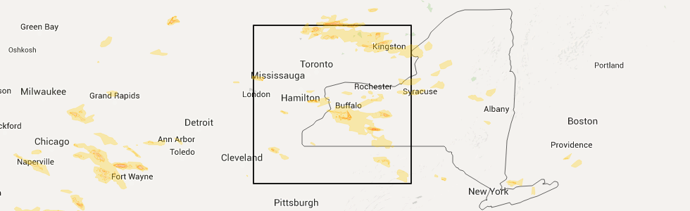
Hail Map for Caledonia, NY
The Caledonia, NY area has had 0 reports of on-the-ground hail by trained spotters, and has been under severe weather warnings 1 time during the past 12 months. Doppler radar has detected hail at or near Caledonia, NY on 7 occasions.
| Name: | Caledonia, NY |
| Where Located: | 52 miles E of Buffalo, NY |
| Map: | Google Map for Caledonia, NY |
| Population: | 2201 |
| Housing Units: | 971 |
| More Info: | Search Google for Caledonia, NY |
5
The Top Recent Hail Date for Caledonia, NY is Monday, June 20, 2016 (1st out of 7)
Hail and Wind Damage Spotted near Caledonia, NY
| Date / Time | Report Details |
|---|---|
| 7/20/2023 8:46 PM EDT |
 At 845 pm edt, severe thunderstorms were located along a line extending from near oakfield to 7 miles south of belfast, moving northeast at 60 mph (radar indicated). Hazards include 60 mph wind gusts. Expect damage to trees and power lines. This storm has a history of producing wind damage across western new york. At 845 pm edt, severe thunderstorms were located along a line extending from near oakfield to 7 miles south of belfast, moving northeast at 60 mph (radar indicated). Hazards include 60 mph wind gusts. Expect damage to trees and power lines. This storm has a history of producing wind damage across western new york.
|
| 4/1/2023 3:45 PM EDT |
 At 344 pm edt, a severe thunderstorm was located over canandaigua, moving east at 45 mph (radar indicated). Hazards include 60 mph wind gusts. expect damage to trees and power lines At 344 pm edt, a severe thunderstorm was located over canandaigua, moving east at 45 mph (radar indicated). Hazards include 60 mph wind gusts. expect damage to trees and power lines
|
| 4/1/2023 2:52 PM EDT |
 At 250 pm edt, severe thunderstorms were located along a line extending from near medina to near houghton to marshburg, moving east at 70 mph (radar indicated). Hazards include 60 mph wind gusts and penny size hail. expect damage to trees and power lines At 250 pm edt, severe thunderstorms were located along a line extending from near medina to near houghton to marshburg, moving east at 70 mph (radar indicated). Hazards include 60 mph wind gusts and penny size hail. expect damage to trees and power lines
|
| 8/29/2022 4:23 PM EDT |
 At 422 pm edt, a severe thunderstorm was located near pavilion, or near geneseo, moving northeast at 50 mph (radar indicated). Hazards include 60 mph wind gusts. expect damage to trees and power lines At 422 pm edt, a severe thunderstorm was located near pavilion, or near geneseo, moving northeast at 50 mph (radar indicated). Hazards include 60 mph wind gusts. expect damage to trees and power lines
|
| 7/25/2022 12:34 AM EDT |
 At 1231 am edt, a line of severe thunderstorms was located from caledonia to perry to east aurora, moving east at 45 mph (radar indicated). Hazards include 60 mph wind gusts. Expect damage to trees and power lines. locations impacted include, batavia, geneseo, east aurora, darien lakes state park, letchworth state park, henrietta, marilla, le roy, springville and pembroke. this includes the following highways, interstate 390 between exits 6 and 12. interstate 90 between exits 48a and 46. hail threat, radar indicated max hail size, <. 75 in wind threat, radar indicated max wind gust, 60 mph. At 1231 am edt, a line of severe thunderstorms was located from caledonia to perry to east aurora, moving east at 45 mph (radar indicated). Hazards include 60 mph wind gusts. Expect damage to trees and power lines. locations impacted include, batavia, geneseo, east aurora, darien lakes state park, letchworth state park, henrietta, marilla, le roy, springville and pembroke. this includes the following highways, interstate 390 between exits 6 and 12. interstate 90 between exits 48a and 46. hail threat, radar indicated max hail size, <. 75 in wind threat, radar indicated max wind gust, 60 mph.
|
| 7/24/2022 11:57 PM EDT |
 At 1157 pm edt, a severe thunderstorm was located near wales center, or 8 miles southeast of east aurora, moving east at 45 mph (radar indicated). Hazards include 60 mph wind gusts. expect damage to trees and power lines At 1157 pm edt, a severe thunderstorm was located near wales center, or 8 miles southeast of east aurora, moving east at 45 mph (radar indicated). Hazards include 60 mph wind gusts. expect damage to trees and power lines
|
| 6/15/2022 8:15 PM EDT |
 At 814 pm edt, a severe thunderstorm was located near pavilion, or 7 miles southeast of batavia, moving east at 15 mph (radar indicated). Hazards include 60 mph wind gusts and quarter size hail. Minor damage to vehicles is possible. Expect wind damage to trees and power lines. At 814 pm edt, a severe thunderstorm was located near pavilion, or 7 miles southeast of batavia, moving east at 15 mph (radar indicated). Hazards include 60 mph wind gusts and quarter size hail. Minor damage to vehicles is possible. Expect wind damage to trees and power lines.
|
| 4/25/2022 7:15 PM EDT | Large tree down across maxwell station r in livingston county NY, 4.6 miles W of Caledonia, NY |
| 4/25/2022 7:08 PM EDT |
 At 707 pm edt, severe thunderstorms were located along a line extending from near holley to near mount morris, moving northeast at 40 mph (radar indicated). Hazards include 70 mph wind gusts and penny size hail. Expect considerable tree damage. Damage is likely to mobile homes, roofs, and outbuildings. At 707 pm edt, severe thunderstorms were located along a line extending from near holley to near mount morris, moving northeast at 40 mph (radar indicated). Hazards include 70 mph wind gusts and penny size hail. Expect considerable tree damage. Damage is likely to mobile homes, roofs, and outbuildings.
|
| 4/25/2022 6:49 PM EDT |
 At 648 pm edt, severe thunderstorms were located along a line extending from near medina to near varysburg, moving northeast at 50 mph (radar indicated). Hazards include 60 mph wind gusts. Expect damage to trees and power lines. locations impacted include, batavia, brockport, medina, albion, le roy, attica, pavilion, byron, caledonia and churchville. This includes interstate 90 between exits 48 and 47. At 648 pm edt, severe thunderstorms were located along a line extending from near medina to near varysburg, moving northeast at 50 mph (radar indicated). Hazards include 60 mph wind gusts. Expect damage to trees and power lines. locations impacted include, batavia, brockport, medina, albion, le roy, attica, pavilion, byron, caledonia and churchville. This includes interstate 90 between exits 48 and 47.
|
| 4/25/2022 6:34 PM EDT |
 At 633 pm edt, severe thunderstorms were located along a line extending from middleport to 6 miles southeast of wales center, moving northeast at 55 mph (radar indicated). Hazards include 60 mph wind gusts. expect damage to trees and power lines At 633 pm edt, severe thunderstorms were located along a line extending from middleport to 6 miles southeast of wales center, moving northeast at 55 mph (radar indicated). Hazards include 60 mph wind gusts. expect damage to trees and power lines
|
| 8/11/2021 8:10 AM EDT |
 At 810 am edt, a severe thunderstorm was located near byron, or 7 miles east of batavia, moving east at 30 mph (radar indicated). Hazards include 60 mph wind gusts. Expect damage to trees and power lines. locations impacted include, rochester, greece, irondequoit, chili, batavia, brockport, east rochester, hilton, brighton and gates-north gates. this includes the following highways, interstate 390 between exits 11 and 12. interstate 90 between exits 48 and 45. hail threat, radar indicated max hail size, <. 75 in wind threat, radar indicated max wind gust, 60 mph. At 810 am edt, a severe thunderstorm was located near byron, or 7 miles east of batavia, moving east at 30 mph (radar indicated). Hazards include 60 mph wind gusts. Expect damage to trees and power lines. locations impacted include, rochester, greece, irondequoit, chili, batavia, brockport, east rochester, hilton, brighton and gates-north gates. this includes the following highways, interstate 390 between exits 11 and 12. interstate 90 between exits 48 and 45. hail threat, radar indicated max hail size, <. 75 in wind threat, radar indicated max wind gust, 60 mph.
|
| 8/11/2021 7:46 AM EDT |
 At 746 am edt, a severe thunderstorm was located near oakfield, or near batavia, moving east at 30 mph (radar indicated). Hazards include 60 mph wind gusts. expect damage to trees and power lines At 746 am edt, a severe thunderstorm was located near oakfield, or near batavia, moving east at 30 mph (radar indicated). Hazards include 60 mph wind gusts. expect damage to trees and power lines
|
| 7/13/2021 7:15 PM EDT |
 At 715 pm edt, severe thunderstorms were located along a line extending from near holley to near caledonia, moving northeast at 40 mph (radar indicated). Hazards include 60 mph wind gusts and quarter size hail. Minor damage to vehicles is possible. Expect wind damage to roofs, siding, and trees. At 715 pm edt, severe thunderstorms were located along a line extending from near holley to near caledonia, moving northeast at 40 mph (radar indicated). Hazards include 60 mph wind gusts and quarter size hail. Minor damage to vehicles is possible. Expect wind damage to roofs, siding, and trees.
|
| 7/6/2021 11:53 AM EDT |
 At 1152 am edt, a severe thunderstorm was located over caledonia, or 9 miles southwest of chili, moving east at 40 mph (radar indicated). Hazards include 60 mph wind gusts. Expect damage to roofs, siding, and trees. locations impacted include, canandaigua, henrietta, le roy, avon, victor, honeoye falls, bristol, caledonia, lima and scottsville. this includes the following highways, interstate 390 between exits 9 and 12. Interstate 90 between exits 47 and 44. At 1152 am edt, a severe thunderstorm was located over caledonia, or 9 miles southwest of chili, moving east at 40 mph (radar indicated). Hazards include 60 mph wind gusts. Expect damage to roofs, siding, and trees. locations impacted include, canandaigua, henrietta, le roy, avon, victor, honeoye falls, bristol, caledonia, lima and scottsville. this includes the following highways, interstate 390 between exits 9 and 12. Interstate 90 between exits 47 and 44.
|
| 7/6/2021 11:32 AM EDT |
 At 1131 am edt, a severe thunderstorm was located near byron, or near batavia, moving east at 45 mph (radar indicated). Hazards include 60 mph wind gusts. expect damage to roofs, siding, and trees At 1131 am edt, a severe thunderstorm was located near byron, or near batavia, moving east at 45 mph (radar indicated). Hazards include 60 mph wind gusts. expect damage to roofs, siding, and trees
|
| 6/21/2021 4:11 PM EDT |
 The severe thunderstorm warning for northeastern wyoming, northern livingston, southeastern genesee, southern monroe and northwestern ontario counties will expire at 415 pm edt, the storm which prompted the warning has moved out of the area. therefore, the warning will be allowed to expire. a severe thunderstorm watch remains in effect until 800 pm edt for western new york. The severe thunderstorm warning for northeastern wyoming, northern livingston, southeastern genesee, southern monroe and northwestern ontario counties will expire at 415 pm edt, the storm which prompted the warning has moved out of the area. therefore, the warning will be allowed to expire. a severe thunderstorm watch remains in effect until 800 pm edt for western new york.
|
| 6/21/2021 3:39 PM EDT |
 At 338 pm edt, a severe thunderstorm was located near avon, or near geneseo, moving east at 45 mph (radar indicated). Hazards include 60 mph wind gusts and penny size hail. Expect damage to roofs, siding, and trees. locations impacted include, rochester, canandaigua, geneseo, east rochester, fairport, brighton, letchworth state park, henrietta, penfield and le roy. this includes the following highways, interstate 390 between exits 7 and 12. Interstate 90 between exits 47 and 44. At 338 pm edt, a severe thunderstorm was located near avon, or near geneseo, moving east at 45 mph (radar indicated). Hazards include 60 mph wind gusts and penny size hail. Expect damage to roofs, siding, and trees. locations impacted include, rochester, canandaigua, geneseo, east rochester, fairport, brighton, letchworth state park, henrietta, penfield and le roy. this includes the following highways, interstate 390 between exits 7 and 12. Interstate 90 between exits 47 and 44.
|
| 6/21/2021 3:18 PM EDT |
 At 318 pm edt, a severe thunderstorm was located near perry, or 10 miles north of letchworth state park, moving east at 45 mph (radar indicated). Hazards include 60 mph wind gusts and penny size hail. expect damage to roofs, siding, and trees At 318 pm edt, a severe thunderstorm was located near perry, or 10 miles north of letchworth state park, moving east at 45 mph (radar indicated). Hazards include 60 mph wind gusts and penny size hail. expect damage to roofs, siding, and trees
|
| 6/20/2021 9:39 PM EDT |
 At 938 pm edt, a severe thunderstorm was located over caledonia, or 9 miles south of chili, moving northeast at 30 mph (radar indicated). Hazards include 60 mph wind gusts and quarter size hail. Minor damage to vehicles is possible. expect wind damage to roofs, siding, and trees. locations impacted include, le roy, avon, honeoye falls, caledonia, scottsville, riga, rush, york, north chili and martin. This includes interstate 390 between exits 10 and 11. At 938 pm edt, a severe thunderstorm was located over caledonia, or 9 miles south of chili, moving northeast at 30 mph (radar indicated). Hazards include 60 mph wind gusts and quarter size hail. Minor damage to vehicles is possible. expect wind damage to roofs, siding, and trees. locations impacted include, le roy, avon, honeoye falls, caledonia, scottsville, riga, rush, york, north chili and martin. This includes interstate 390 between exits 10 and 11.
|
| 6/20/2021 9:18 PM EDT |
 At 917 pm edt, a severe thunderstorm was located near pavilion, or 8 miles northwest of geneseo, moving northeast at 40 mph (radar indicated). Hazards include 60 mph wind gusts and quarter size hail. Minor damage to vehicles is possible. Expect wind damage to roofs, siding, and trees. At 917 pm edt, a severe thunderstorm was located near pavilion, or 8 miles northwest of geneseo, moving northeast at 40 mph (radar indicated). Hazards include 60 mph wind gusts and quarter size hail. Minor damage to vehicles is possible. Expect wind damage to roofs, siding, and trees.
|
| 11/15/2020 4:32 PM EST |
 At 431 pm est, severe thunderstorms were located along a line extending from near rochester to 8 miles west of alfred, moving east at 55 mph (radar indicated). Hazards include 60 mph wind gusts. Expect damage to roofs, siding, and trees. locations impacted include, rochester, greece, irondequoit, chili, geneva, canandaigua, geneseo, east rochester, hilton, webster, mount morris, portageville, angelica, fillmore, and belmont. this includes the following highways, interstate 390 between exits 4 and 12. interstate 90 between exits 46 and 42. Interstate 86 between exits 29 and 33. At 431 pm est, severe thunderstorms were located along a line extending from near rochester to 8 miles west of alfred, moving east at 55 mph (radar indicated). Hazards include 60 mph wind gusts. Expect damage to roofs, siding, and trees. locations impacted include, rochester, greece, irondequoit, chili, geneva, canandaigua, geneseo, east rochester, hilton, webster, mount morris, portageville, angelica, fillmore, and belmont. this includes the following highways, interstate 390 between exits 4 and 12. interstate 90 between exits 46 and 42. Interstate 86 between exits 29 and 33.
|
| 11/15/2020 3:57 PM EST |
 At 355 pm est, severe thunderstorms were located along a line extending from near albion to 6 miles south of franklinville, moving east at 55 mph (radar indicated). Hazards include 60 mph wind gusts. expect damage to roofs, siding, and trees At 355 pm est, severe thunderstorms were located along a line extending from near albion to 6 miles south of franklinville, moving east at 55 mph (radar indicated). Hazards include 60 mph wind gusts. expect damage to roofs, siding, and trees
|
| 8/27/2020 5:06 PM EDT |
 At 506 pm edt, a severe thunderstorm was located over conesus, or 10 miles southeast of geneseo, moving southeast at 40 mph (radar indicated). Hazards include 60 mph wind gusts and quarter size hail. Minor damage to vehicles is possible. expect wind damage to roofs, siding, and trees. locations impacted include, geneseo, dansville, letchworth state park, le roy, perry, warsaw, avon, mount morris, honeoye falls and pavilion. This includes interstate 390 between exits 4 and 11. At 506 pm edt, a severe thunderstorm was located over conesus, or 10 miles southeast of geneseo, moving southeast at 40 mph (radar indicated). Hazards include 60 mph wind gusts and quarter size hail. Minor damage to vehicles is possible. expect wind damage to roofs, siding, and trees. locations impacted include, geneseo, dansville, letchworth state park, le roy, perry, warsaw, avon, mount morris, honeoye falls and pavilion. This includes interstate 390 between exits 4 and 11.
|
| 8/27/2020 4:28 PM EDT |
 At 428 pm edt, a severe thunderstorm was located over pavilion, or 9 miles southeast of batavia, moving southeast at 40 mph (radar indicated). Hazards include ping pong ball size hail and 60 mph wind gusts. People and animals outdoors will be injured. expect hail damage to roofs, siding, windows, and vehicles. Expect wind damage to roofs, siding, and trees. At 428 pm edt, a severe thunderstorm was located over pavilion, or 9 miles southeast of batavia, moving southeast at 40 mph (radar indicated). Hazards include ping pong ball size hail and 60 mph wind gusts. People and animals outdoors will be injured. expect hail damage to roofs, siding, windows, and vehicles. Expect wind damage to roofs, siding, and trees.
|
| 8/27/2020 4:07 PM EDT |
 At 407 pm edt, a severe thunderstorm was located near batavia, moving east at 15 mph (radar indicated). Hazards include 60 mph wind gusts and half dollar size hail. Minor damage to vehicles is possible. expect wind damage to roofs, siding, and trees. locations impacted include, batavia, geneseo, letchworth state park, le roy, perry, warsaw, avon, mount morris, honeoye falls and attica. this includes the following highways, interstate 390 between exits 6 and 10. Interstate 90 near exit 48. At 407 pm edt, a severe thunderstorm was located near batavia, moving east at 15 mph (radar indicated). Hazards include 60 mph wind gusts and half dollar size hail. Minor damage to vehicles is possible. expect wind damage to roofs, siding, and trees. locations impacted include, batavia, geneseo, letchworth state park, le roy, perry, warsaw, avon, mount morris, honeoye falls and attica. this includes the following highways, interstate 390 between exits 6 and 10. Interstate 90 near exit 48.
|
| 8/27/2020 3:50 PM EDT |
 At 349 pm edt, a severe thunderstorm was located near batavia, moving east at 35 mph (radar indicated). Hazards include 60 mph wind gusts and quarter size hail. Minor damage to vehicles is possible. expect wind damage to roofs, siding, and trees. locations impacted include, batavia, geneseo, letchworth state park, le roy, perry, warsaw, avon, mount morris, honeoye falls and attica. this includes the following highways, interstate 390 between exits 6 and 10. Interstate 90 near exit 48. At 349 pm edt, a severe thunderstorm was located near batavia, moving east at 35 mph (radar indicated). Hazards include 60 mph wind gusts and quarter size hail. Minor damage to vehicles is possible. expect wind damage to roofs, siding, and trees. locations impacted include, batavia, geneseo, letchworth state park, le roy, perry, warsaw, avon, mount morris, honeoye falls and attica. this includes the following highways, interstate 390 between exits 6 and 10. Interstate 90 near exit 48.
|
| 8/27/2020 3:29 PM EDT |
 At 328 pm edt, a severe thunderstorm was located near batavia, moving east at 20 mph (radar indicated). Hazards include 60 mph wind gusts and quarter size hail. Minor damage to vehicles is possible. Expect wind damage to roofs, siding, and trees. At 328 pm edt, a severe thunderstorm was located near batavia, moving east at 20 mph (radar indicated). Hazards include 60 mph wind gusts and quarter size hail. Minor damage to vehicles is possible. Expect wind damage to roofs, siding, and trees.
|
| 8/27/2020 3:03 PM EDT |
 At 302 pm edt, a severe thunderstorm was located near caledonia, or 9 miles north of geneseo, moving east at 45 mph (radar indicated). Hazards include 60 mph wind gusts and quarter size hail. Minor damage to vehicles is possible. expect wind damage to roofs, siding, and trees. locations impacted include, batavia, geneseo, letchworth state park, le roy, pembroke, avon, mount morris, honeoye falls, pavilion and byron. this includes the following highways, interstate 390 between exits 6 and 11. Interstate 90 between exits 48a and 47. At 302 pm edt, a severe thunderstorm was located near caledonia, or 9 miles north of geneseo, moving east at 45 mph (radar indicated). Hazards include 60 mph wind gusts and quarter size hail. Minor damage to vehicles is possible. expect wind damage to roofs, siding, and trees. locations impacted include, batavia, geneseo, letchworth state park, le roy, pembroke, avon, mount morris, honeoye falls, pavilion and byron. this includes the following highways, interstate 390 between exits 6 and 11. Interstate 90 between exits 48a and 47.
|
| 8/27/2020 2:31 PM EDT |
 At 231 pm edt, a severe thunderstorm was located over oakfield, or near batavia, moving east at 45 mph (radar indicated). Hazards include 60 mph wind gusts and quarter size hail. Minor damage to vehicles is possible. Expect wind damage to roofs, siding, and trees. At 231 pm edt, a severe thunderstorm was located over oakfield, or near batavia, moving east at 45 mph (radar indicated). Hazards include 60 mph wind gusts and quarter size hail. Minor damage to vehicles is possible. Expect wind damage to roofs, siding, and trees.
|
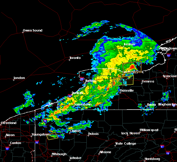
| 7/29/2020 7:08 PM EDT |
 At 708 pm edt, a severe thunderstorm was located near byron, or 10 miles south of brockport, moving east at 30 mph (radar indicated). Hazards include 60 mph wind gusts and quarter size hail. Minor damage to vehicles is possible. expect wind damage to roofs, siding, and trees. locations impacted include, henrietta, victor, honeoye falls, bristol, caledonia, lima, scottsville, churchville, bloomfield and farmington. this includes the following highways, interstate 390 between exits 11 and 12. Interstate 90 between exits 47 and 44. At 708 pm edt, a severe thunderstorm was located near byron, or 10 miles south of brockport, moving east at 30 mph (radar indicated). Hazards include 60 mph wind gusts and quarter size hail. Minor damage to vehicles is possible. expect wind damage to roofs, siding, and trees. locations impacted include, henrietta, victor, honeoye falls, bristol, caledonia, lima, scottsville, churchville, bloomfield and farmington. this includes the following highways, interstate 390 between exits 11 and 12. Interstate 90 between exits 47 and 44.
|
| 7/29/2020 6:50 PM EDT |
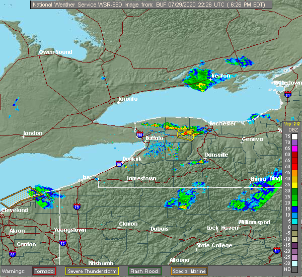 At 650 pm edt, a severe thunderstorm capable of producing a tornado was located over scottsville, or 7 miles south of chili, moving east at 30 mph (radar indicated rotation). Hazards include tornado and quarter size hail. Flying debris will be dangerous to those caught without shelter. mobile homes will be damaged or destroyed. damage to roofs, windows, and vehicles will occur. tree damage is likely. this dangerous storm will be near, lima around 705 pm edt. honeoye falls around 710 pm edt. victor and bloomfield around 725 pm edt. other locations impacted by this tornadic thunderstorm include industry, fishers, martin, mendon, east bloomfield, farmington, west bloomfield, holcomb, garbutt and rush. this includes the following highways, interstate 390 near exit 11. Interstate 90 between exits 45 and 44. At 650 pm edt, a severe thunderstorm capable of producing a tornado was located over scottsville, or 7 miles south of chili, moving east at 30 mph (radar indicated rotation). Hazards include tornado and quarter size hail. Flying debris will be dangerous to those caught without shelter. mobile homes will be damaged or destroyed. damage to roofs, windows, and vehicles will occur. tree damage is likely. this dangerous storm will be near, lima around 705 pm edt. honeoye falls around 710 pm edt. victor and bloomfield around 725 pm edt. other locations impacted by this tornadic thunderstorm include industry, fishers, martin, mendon, east bloomfield, farmington, west bloomfield, holcomb, garbutt and rush. this includes the following highways, interstate 390 near exit 11. Interstate 90 between exits 45 and 44.
|
| 7/29/2020 6:37 PM EDT |
 At 637 pm edt, a severe thunderstorm was located near le roy, or 11 miles east of batavia, moving east at 25 mph (radar indicated). Hazards include 60 mph wind gusts and penny size hail. expect damage to roofs, siding, and trees At 637 pm edt, a severe thunderstorm was located near le roy, or 11 miles east of batavia, moving east at 25 mph (radar indicated). Hazards include 60 mph wind gusts and penny size hail. expect damage to roofs, siding, and trees
|
| 7/19/2020 3:15 PM EDT |
 At 313 pm edt, a severe thunderstorm was located near lima, or 13 miles east of geneseo, moving east at 50 mph (radar indicated). Hazards include 60 mph wind gusts. Expect damage to roofs, siding, and trees. locations impacted include, canandaigua, geneseo, east rochester, fairport, henrietta, avon, mount morris, victor, honeoye falls and bristol. this includes the following highways, interstate 390 between exits 7 and 12. Interstate 90 between exits 46 and 44. At 313 pm edt, a severe thunderstorm was located near lima, or 13 miles east of geneseo, moving east at 50 mph (radar indicated). Hazards include 60 mph wind gusts. Expect damage to roofs, siding, and trees. locations impacted include, canandaigua, geneseo, east rochester, fairport, henrietta, avon, mount morris, victor, honeoye falls and bristol. this includes the following highways, interstate 390 between exits 7 and 12. Interstate 90 between exits 46 and 44.
|
| 7/19/2020 2:43 PM EDT |
 At 242 pm edt, a severe thunderstorm was located near pavilion, or 13 miles southeast of batavia, moving east at 50 mph (radar indicated). Hazards include 60 mph wind gusts. expect damage to roofs, siding, and trees At 242 pm edt, a severe thunderstorm was located near pavilion, or 13 miles southeast of batavia, moving east at 50 mph (radar indicated). Hazards include 60 mph wind gusts. expect damage to roofs, siding, and trees
|
| 6/11/2020 12:27 AM EDT |
 The severe thunderstorm warning for northeastern wyoming, northern livingston, eastern orleans, monroe, eastern genesee and northwestern ontario counties will expire at 1230 am edt, the storm which prompted the warning has weakened below severe limits, and no longer poses an immediate threat to life or property. therefore, the warning will be allowed to expire. however gusty winds and heavy rain are still possible with this thunderstorm. a severe thunderstorm watch remains in effect until 200 am edt for western new york. The severe thunderstorm warning for northeastern wyoming, northern livingston, eastern orleans, monroe, eastern genesee and northwestern ontario counties will expire at 1230 am edt, the storm which prompted the warning has weakened below severe limits, and no longer poses an immediate threat to life or property. therefore, the warning will be allowed to expire. however gusty winds and heavy rain are still possible with this thunderstorm. a severe thunderstorm watch remains in effect until 200 am edt for western new york.
|
| 6/10/2020 11:54 PM EDT |
 At 1154 pm edt, a severe thunderstorm was located over caledonia, or 7 miles southwest of chili, moving east at 50 mph (radar indicated). Hazards include 60 mph wind gusts. Expect damage to roofs, siding, and trees. locations impacted include, rochester, greece, irondequoit, chili, brockport, geneseo, east rochester, hilton, webster and fairport. this includes the following highways, interstate 390 between exits 8 and 12. Interstate 90 between exits 47 and 45. At 1154 pm edt, a severe thunderstorm was located over caledonia, or 7 miles southwest of chili, moving east at 50 mph (radar indicated). Hazards include 60 mph wind gusts. Expect damage to roofs, siding, and trees. locations impacted include, rochester, greece, irondequoit, chili, brockport, geneseo, east rochester, hilton, webster and fairport. this includes the following highways, interstate 390 between exits 8 and 12. Interstate 90 between exits 47 and 45.
|
| 6/10/2020 11:26 PM EDT |
 At 1125 pm edt, a severe thunderstorm was located over pembroke, or 7 miles north of darien lakes state park, moving east at 50 mph (radar indicated). Hazards include 60 mph wind gusts. expect damage to roofs, siding, and trees At 1125 pm edt, a severe thunderstorm was located over pembroke, or 7 miles north of darien lakes state park, moving east at 50 mph (radar indicated). Hazards include 60 mph wind gusts. expect damage to roofs, siding, and trees
|
| 6/2/2020 11:31 PM EDT |
 At 1130 pm edt, a severe thunderstorm was located near honeoye falls, or 12 miles southeast of chili, moving southeast at 50 mph. another severe thunderstorm was located near leroy, moving southeast at 50 mph (radar indicated). Hazards include 60 mph wind gusts and quarter size hail. Minor damage to vehicles is possible. expect wind damage to roofs, siding, and trees. locations impacted include, rochester, chili, brockport, brighton, henrietta, le roy, spencerport, avon, victor and honeoye falls. this includes the following highways, interstate 390 between exits 8 and 12. Interstate 90 between exits 47 and 44. At 1130 pm edt, a severe thunderstorm was located near honeoye falls, or 12 miles southeast of chili, moving southeast at 50 mph. another severe thunderstorm was located near leroy, moving southeast at 50 mph (radar indicated). Hazards include 60 mph wind gusts and quarter size hail. Minor damage to vehicles is possible. expect wind damage to roofs, siding, and trees. locations impacted include, rochester, chili, brockport, brighton, henrietta, le roy, spencerport, avon, victor and honeoye falls. this includes the following highways, interstate 390 between exits 8 and 12. Interstate 90 between exits 47 and 44.
|
| 6/2/2020 11:06 PM EDT |
 At 1106 pm edt, a severe thunderstorm was located near churchville, or near brockport, moving southeast at 55 mph (radar indicated). Hazards include 60 mph wind gusts and half dollar size hail. Minor damage to vehicles is possible. Expect wind damage to roofs, siding, and trees. At 1106 pm edt, a severe thunderstorm was located near churchville, or near brockport, moving southeast at 55 mph (radar indicated). Hazards include 60 mph wind gusts and half dollar size hail. Minor damage to vehicles is possible. Expect wind damage to roofs, siding, and trees.
|
| 3/29/2020 3:22 PM EDT |
 At 322 pm edt, a severe thunderstorm was located near le roy, or 11 miles northwest of geneseo, moving east at 55 mph (radar indicated). Hazards include 60 mph wind gusts and nickel size hail. Expect damage to roofs, siding, and trees. locations impacted include, rochester, east rochester, fairport, brighton, henrietta, penfield, le roy, avon, victor and honeoye falls. this includes the following highways, interstate 390 between exits 11 and 12. Interstate 90 between exits 46 and 45. At 322 pm edt, a severe thunderstorm was located near le roy, or 11 miles northwest of geneseo, moving east at 55 mph (radar indicated). Hazards include 60 mph wind gusts and nickel size hail. Expect damage to roofs, siding, and trees. locations impacted include, rochester, east rochester, fairport, brighton, henrietta, penfield, le roy, avon, victor and honeoye falls. this includes the following highways, interstate 390 between exits 11 and 12. Interstate 90 between exits 46 and 45.
|
| 3/29/2020 3:00 PM EDT |
 At 259 pm edt, severe thunderstorms were located along a line extending from hamlin beach state park to near churchville, moving east at 50 mph (radar indicated). Hazards include 60 mph wind gusts and nickel size hail. Expect damage to roofs, siding, and trees. locations impacted include, brockport, spencerport, rochester, greece, irondequoit, chili, brockport, east rochester, hilton, webster, and brighton. this includes the following highways, interstate 390 between exits 11 and 12. Interstate 90 between exits 47 and 45. At 259 pm edt, severe thunderstorms were located along a line extending from hamlin beach state park to near churchville, moving east at 50 mph (radar indicated). Hazards include 60 mph wind gusts and nickel size hail. Expect damage to roofs, siding, and trees. locations impacted include, brockport, spencerport, rochester, greece, irondequoit, chili, brockport, east rochester, hilton, webster, and brighton. this includes the following highways, interstate 390 between exits 11 and 12. Interstate 90 between exits 47 and 45.
|
| 3/29/2020 2:41 PM EDT |
 At 241 pm edt, severe thunderstorms were located along a line extending from near albion to near batavia, moving east at 50 mph (radar indicated). Hazards include 60 mph wind gusts and nickel size hail. expect damage to roofs, siding, and trees At 241 pm edt, severe thunderstorms were located along a line extending from near albion to near batavia, moving east at 50 mph (radar indicated). Hazards include 60 mph wind gusts and nickel size hail. expect damage to roofs, siding, and trees
|
| 8/16/2019 6:02 PM EDT |
 At 601 pm edt, a severe thunderstorm was located near avon and moving east at 20 mph (radar indicated). Hazards include 60 mph wind gusts and quarter size hail. Minor damage to vehicles is possible. expect wind damage to roofs, siding, and trees. locations impacted include, geneseo, le roy, avon, honeoye falls, caledonia, lima, scottsville, rush, york and livonia. This includes interstate 390 between exits 8 and 11. At 601 pm edt, a severe thunderstorm was located near avon and moving east at 20 mph (radar indicated). Hazards include 60 mph wind gusts and quarter size hail. Minor damage to vehicles is possible. expect wind damage to roofs, siding, and trees. locations impacted include, geneseo, le roy, avon, honeoye falls, caledonia, lima, scottsville, rush, york and livonia. This includes interstate 390 between exits 8 and 11.
|
| 8/16/2019 5:37 PM EDT |
 At 537 pm edt, a severe thunderstorm was located over pavilion and moving east at 20 mph (radar indicated). Hazards include 60 mph wind gusts and quarter size hail. Minor damage to vehicles is possible. Expect wind damage to roofs, siding, and trees. At 537 pm edt, a severe thunderstorm was located over pavilion and moving east at 20 mph (radar indicated). Hazards include 60 mph wind gusts and quarter size hail. Minor damage to vehicles is possible. Expect wind damage to roofs, siding, and trees.
|
| 8/8/2019 12:13 PM EDT |
 At 1213 pm edt, severe thunderstorms were located along a line extending from near hilton to near chili to near pavilion, moving east at 40 mph (radar indicated). Hazards include 60 mph wind gusts. Expect damage to roofs, siding, and trees. locations impacted include, rochester, greece, irondequoit, chili, brockport, east rochester, hilton, webster, fairport and brighton. this includes the following highways, interstate 390 between exits 10 and 12. Interstate 90 between exits 47 and 46. At 1213 pm edt, severe thunderstorms were located along a line extending from near hilton to near chili to near pavilion, moving east at 40 mph (radar indicated). Hazards include 60 mph wind gusts. Expect damage to roofs, siding, and trees. locations impacted include, rochester, greece, irondequoit, chili, brockport, east rochester, hilton, webster, fairport and brighton. this includes the following highways, interstate 390 between exits 10 and 12. Interstate 90 between exits 47 and 46.
|
| 8/8/2019 11:50 AM EDT |
 At 1149 am edt, severe thunderstorms were located along a line extending from near hamlin beach state park to byron to near attica, moving east at 35 mph (radar indicated). Hazards include 60 mph wind gusts. expect damage to roofs, siding, and trees At 1149 am edt, severe thunderstorms were located along a line extending from near hamlin beach state park to byron to near attica, moving east at 35 mph (radar indicated). Hazards include 60 mph wind gusts. expect damage to roofs, siding, and trees
|
| 5/25/2019 7:49 PM EDT |
 At 748 pm edt, severe thunderstorms were located along a line extending from avon to near portageville, moving east at 45 mph (radar indicated). Hazards include 60 mph wind gusts. Expect damage to roofs, siding, and trees. locations impacted include, canandaigua, geneseo, dansville, letchworth state park, perry, warsaw, avon, mount morris, victor and honeoye falls. this includes the following highways, interstate 390 between exits 4 and 11. Interstate 90 between exits 45 and 43. At 748 pm edt, severe thunderstorms were located along a line extending from avon to near portageville, moving east at 45 mph (radar indicated). Hazards include 60 mph wind gusts. Expect damage to roofs, siding, and trees. locations impacted include, canandaigua, geneseo, dansville, letchworth state park, perry, warsaw, avon, mount morris, victor and honeoye falls. this includes the following highways, interstate 390 between exits 4 and 11. Interstate 90 between exits 45 and 43.
|
| 5/25/2019 7:29 PM EDT |
 At 729 pm edt, severe thunderstorms were located along a line extending from near batavia to 6 miles southeast of wales center, moving east at 35 mph (radar indicated). Hazards include 60 mph wind gusts. expect damage to roofs, siding, and trees At 729 pm edt, severe thunderstorms were located along a line extending from near batavia to 6 miles southeast of wales center, moving east at 35 mph (radar indicated). Hazards include 60 mph wind gusts. expect damage to roofs, siding, and trees
|
| 9/21/2018 6:39 PM EDT | Tree down and wire in livingston county NY, 0.2 miles S of Caledonia, NY |
| 9/21/2018 6:31 PM EDT |
 The national weather service in buffalo has issued a * severe thunderstorm warning for. southwestern wayne county in western new york. wyoming county in western new york. livingston county in western new york. Southern monroe county in western new york. The national weather service in buffalo has issued a * severe thunderstorm warning for. southwestern wayne county in western new york. wyoming county in western new york. livingston county in western new york. Southern monroe county in western new york.
|
| 10/15/2017 4:57 PM EDT |
 At 456 pm edt, severe thunderstorms were located along a line extending from 9 miles north of ontario to avon to near rushford, moving east at 50 mph (radar indicated). Hazards include 60 mph wind gusts. Expect wind damage to trees and power lines. locations impacted include, rochester, irondequoit, canandaigua, geneseo, east rochester, webster, fairport and dansville. this includes the following highways, interstate 390 between exits 4 and 12. Interstate 90 between exits 46 and 43. At 456 pm edt, severe thunderstorms were located along a line extending from 9 miles north of ontario to avon to near rushford, moving east at 50 mph (radar indicated). Hazards include 60 mph wind gusts. Expect wind damage to trees and power lines. locations impacted include, rochester, irondequoit, canandaigua, geneseo, east rochester, webster, fairport and dansville. this includes the following highways, interstate 390 between exits 4 and 12. Interstate 90 between exits 46 and 43.
|
| 10/15/2017 4:36 PM EDT |
 At 432 pm edt, severe thunderstorms were located along a line extending from near hilton to near pavilion to ashford hollow, moving east at 50 mph (radar indicated). Hazards include 60 mph wind gusts. expect wind damage to trees and power lines At 432 pm edt, severe thunderstorms were located along a line extending from near hilton to near pavilion to ashford hollow, moving east at 50 mph (radar indicated). Hazards include 60 mph wind gusts. expect wind damage to trees and power lines
|
| 8/22/2017 1:25 PM EDT |
 The severe thunderstorm warning for western wayne, northeastern livingston, monroe, east central genesee and northwestern ontario counties will expire at 130 pm edt, the storms which prompted the warning have moved out of the area. therefore the warning will be allowed to expire. remember, a severe thunderstorm warning still remains in effect for eastern monroe, wayne and ontario counties. a tornado watch remains in effect until 900 pm edt for western new york. The severe thunderstorm warning for western wayne, northeastern livingston, monroe, east central genesee and northwestern ontario counties will expire at 130 pm edt, the storms which prompted the warning have moved out of the area. therefore the warning will be allowed to expire. remember, a severe thunderstorm warning still remains in effect for eastern monroe, wayne and ontario counties. a tornado watch remains in effect until 900 pm edt for western new york.
|
| 8/22/2017 1:04 PM EDT |
 At 103 pm edt, severe thunderstorms were located along a line extending from gates-north gates to near le roy, moving northeast at 55 mph (radar indicated). Hazards include 60 mph wind gusts. Expect wind damage to trees and power lines. locations impacted include, rochester, greece, irondequoit, chili, geneseo, east rochester, webster and fairport. this includes the following highways, interstate 390 between exits 8 and 12. interstate 90 between exits 46 and 44. A tornado watch remains in effect until 900 pm edt for western new york. At 103 pm edt, severe thunderstorms were located along a line extending from gates-north gates to near le roy, moving northeast at 55 mph (radar indicated). Hazards include 60 mph wind gusts. Expect wind damage to trees and power lines. locations impacted include, rochester, greece, irondequoit, chili, geneseo, east rochester, webster and fairport. this includes the following highways, interstate 390 between exits 8 and 12. interstate 90 between exits 46 and 44. A tornado watch remains in effect until 900 pm edt for western new york.
|
| 8/22/2017 12:34 PM EDT |
 At 1234 pm edt, severe thunderstorms were located along a line extending from near batavia to near varysburg, moving northeast at 55 mph (radar indicated). Hazards include 60 mph wind gusts. expect wind damage to trees and power lines At 1234 pm edt, severe thunderstorms were located along a line extending from near batavia to near varysburg, moving northeast at 55 mph (radar indicated). Hazards include 60 mph wind gusts. expect wind damage to trees and power lines
|
| 7/20/2017 1:05 PM EDT |
 At 104 pm edt, a severe thunderstorm was located near scottsville, or near chili, moving east at 35 mph (radar indicated). Hazards include 60 mph wind gusts. Expect wind damage to trees and power lines. locations impacted include, rochester, greece, irondequoit, chili, east rochester, webster, fairport and brighton. this includes the following highways, interstate 390 between exits 10 and 12. Interstate 90 near exit 46. At 104 pm edt, a severe thunderstorm was located near scottsville, or near chili, moving east at 35 mph (radar indicated). Hazards include 60 mph wind gusts. Expect wind damage to trees and power lines. locations impacted include, rochester, greece, irondequoit, chili, east rochester, webster, fairport and brighton. this includes the following highways, interstate 390 between exits 10 and 12. Interstate 90 near exit 46.
|
| 7/20/2017 12:48 PM EDT |
 At 1247 pm edt, a severe thunderstorm was located over churchville, or near chili, moving east at 45 mph (radar indicated). Hazards include 60 mph wind gusts. Expect wind damage to trees and power lines. locations impacted include, rochester, greece, irondequoit, chili, batavia, canandaigua, brockport and geneseo. this includes the following highways, interstate 390 between exits 8 and 12. Interstate 90 between exits 48a and 43. At 1247 pm edt, a severe thunderstorm was located over churchville, or near chili, moving east at 45 mph (radar indicated). Hazards include 60 mph wind gusts. Expect wind damage to trees and power lines. locations impacted include, rochester, greece, irondequoit, chili, batavia, canandaigua, brockport and geneseo. this includes the following highways, interstate 390 between exits 8 and 12. Interstate 90 between exits 48a and 43.
|
| 7/20/2017 12:21 PM EDT |
 At 1221 pm edt, a severe thunderstorm was located near albion, moving east at 45 mph (radar indicated). Hazards include 60 mph wind gusts. expect wind damage to trees and power lines At 1221 pm edt, a severe thunderstorm was located near albion, moving east at 45 mph (radar indicated). Hazards include 60 mph wind gusts. expect wind damage to trees and power lines
|
| 6/26/2017 5:39 PM EDT |
 The severe thunderstorm warning for northwestern livingston, southwestern monroe and southeastern genesee counties will expire at 545 pm edt, the storm which prompted the warning has moved out of the area. therefore the warning will be allowed to expire. however, a new severe thunderstorm warning remains in effect for southeastern monroe county and western wayne county in western new york. The severe thunderstorm warning for northwestern livingston, southwestern monroe and southeastern genesee counties will expire at 545 pm edt, the storm which prompted the warning has moved out of the area. therefore the warning will be allowed to expire. however, a new severe thunderstorm warning remains in effect for southeastern monroe county and western wayne county in western new york.
|
| 6/26/2017 5:11 PM EDT |
 At 511 pm edt, a severe thunderstorm was located over pavilion, or 9 miles southeast of batavia, moving northeast at 30 mph (trained weather spotters). Hazards include 60 mph wind gusts and quarter size hail. Minor damage to vehicles is possible. expect wind damage to trees and power lines. locations impacted include, le roy, avon, caledonia, scottsville, riga, industry, east bethany and mumford. This includes interstate 90 near exit 47. At 511 pm edt, a severe thunderstorm was located over pavilion, or 9 miles southeast of batavia, moving northeast at 30 mph (trained weather spotters). Hazards include 60 mph wind gusts and quarter size hail. Minor damage to vehicles is possible. expect wind damage to trees and power lines. locations impacted include, le roy, avon, caledonia, scottsville, riga, industry, east bethany and mumford. This includes interstate 90 near exit 47.
|
| 6/26/2017 4:47 PM EDT |
 At 447 pm edt, a severe thunderstorm was located near attica, or 11 miles southeast of darien lakes state park, moving northeast at 30 mph (radar indicated). Hazards include 60 mph wind gusts and quarter size hail. Minor damage to vehicles is possible. Expect wind damage to trees and power lines. At 447 pm edt, a severe thunderstorm was located near attica, or 11 miles southeast of darien lakes state park, moving northeast at 30 mph (radar indicated). Hazards include 60 mph wind gusts and quarter size hail. Minor damage to vehicles is possible. Expect wind damage to trees and power lines.
|
| 6/18/2017 5:13 PM EDT |
 At 513 pm edt, severe thunderstorms were located along a line extending from spencerport to near caledonia, moving northeast at 45 mph (radar indicated). Hazards include 60 mph wind gusts. Expect wind damage to trees and power lines. locations impacted include, rochester, greece, chili, brighton, gates-north gates, le roy, spencerport and warsaw. this includes the following highways, interstate 390 between exits 10 and 12. Interstate 90 between exits 47 and 46. At 513 pm edt, severe thunderstorms were located along a line extending from spencerport to near caledonia, moving northeast at 45 mph (radar indicated). Hazards include 60 mph wind gusts. Expect wind damage to trees and power lines. locations impacted include, rochester, greece, chili, brighton, gates-north gates, le roy, spencerport and warsaw. this includes the following highways, interstate 390 between exits 10 and 12. Interstate 90 between exits 47 and 46.
|
| 6/18/2017 4:54 PM EDT |
 At 454 pm edt, a severe thunderstorm was located over pavilion, or 9 miles southeast of batavia, moving northeast at 35 mph (radar indicated). Hazards include 60 mph wind gusts. expect wind damage to trees and power lines At 454 pm edt, a severe thunderstorm was located over pavilion, or 9 miles southeast of batavia, moving northeast at 35 mph (radar indicated). Hazards include 60 mph wind gusts. expect wind damage to trees and power lines
|
| 6/15/2017 4:54 PM EDT |
 At 454 pm edt, a severe thunderstorm was located near le roy, or 8 miles southeast of batavia, moving northeast at 20 mph (radar indicated). Hazards include 60 mph wind gusts and quarter size hail. Minor damage to vehicles is possible. Expect wind damage to trees and power lines. At 454 pm edt, a severe thunderstorm was located near le roy, or 8 miles southeast of batavia, moving northeast at 20 mph (radar indicated). Hazards include 60 mph wind gusts and quarter size hail. Minor damage to vehicles is possible. Expect wind damage to trees and power lines.
|
| 5/1/2017 4:54 PM EDT |
 At 453 pm edt, severe thunderstorms were located along a line extending from near webster to near east rochester to near honeoye falls to near portageville, moving east at 40 mph (radar indicated). Hazards include 70 mph wind gusts. Expect considerable tree damage. damage is likely to mobile homes, roofs, and outbuildings. locations impacted include, rochester, greece, irondequoit, chili, geneseo, hilton, brighton and gates-north gates. this includes the following highways, interstate 390 between exits 6 and 12. interstate 90 near exit 46. A tornado watch remains in effect until 1000 pm edt for western new york. At 453 pm edt, severe thunderstorms were located along a line extending from near webster to near east rochester to near honeoye falls to near portageville, moving east at 40 mph (radar indicated). Hazards include 70 mph wind gusts. Expect considerable tree damage. damage is likely to mobile homes, roofs, and outbuildings. locations impacted include, rochester, greece, irondequoit, chili, geneseo, hilton, brighton and gates-north gates. this includes the following highways, interstate 390 between exits 6 and 12. interstate 90 near exit 46. A tornado watch remains in effect until 1000 pm edt for western new york.
|
| 5/1/2017 4:24 PM EDT |
 At 423 pm edt, severe thunderstorms were located along a line extending from holley to near le roy to warsaw, moving east at 65 mph (radar indicated). Hazards include 70 mph wind gusts. Expect considerable tree damage. Damage is likely to mobile homes, roofs, and outbuildings. At 423 pm edt, severe thunderstorms were located along a line extending from holley to near le roy to warsaw, moving east at 65 mph (radar indicated). Hazards include 70 mph wind gusts. Expect considerable tree damage. Damage is likely to mobile homes, roofs, and outbuildings.
|
| 5/1/2017 4:16 PM EDT |
 At 415 pm edt, severe thunderstorms were located along a line extending from near albion to near batavia to near varysburg, moving northeast at 65 mph (radar indicated). Hazards include 70 mph wind gusts. Expect considerable tree damage. Damage is likely to mobile homes, roofs, and outbuildings. At 415 pm edt, severe thunderstorms were located along a line extending from near albion to near batavia to near varysburg, moving northeast at 65 mph (radar indicated). Hazards include 70 mph wind gusts. Expect considerable tree damage. Damage is likely to mobile homes, roofs, and outbuildings.
|
| 4/30/2017 7:37 PM EDT |
 At 737 pm edt, a severe thunderstorm was located near warsaw, or 12 miles northwest of letchworth state park, moving northeast at 45 mph (radar indicated). Hazards include 60 mph wind gusts and nickel size hail. expect damage to roofs, siding, and trees At 737 pm edt, a severe thunderstorm was located near warsaw, or 12 miles northwest of letchworth state park, moving northeast at 45 mph (radar indicated). Hazards include 60 mph wind gusts and nickel size hail. expect damage to roofs, siding, and trees
|
| 9/17/2016 7:30 PM EDT |
 At 729 pm edt, a severe thunderstorm was located near geneseo, moving east at 45 mph (radar indicated). Hazards include 60 mph wind gusts. Expect damage to roofs. siding. And trees. At 729 pm edt, a severe thunderstorm was located near geneseo, moving east at 45 mph (radar indicated). Hazards include 60 mph wind gusts. Expect damage to roofs. siding. And trees.
|
| 9/17/2016 6:37 PM EDT |
 At 637 pm edt, severe thunderstorms were located along a line extending from 6 miles northwest of holley to near byron to 6 miles south of batavia, moving east at 60 mph (radar indicated). Hazards include 60 mph wind gusts. Expect damage to roofs. siding. And trees. At 637 pm edt, severe thunderstorms were located along a line extending from 6 miles northwest of holley to near byron to 6 miles south of batavia, moving east at 60 mph (radar indicated). Hazards include 60 mph wind gusts. Expect damage to roofs. siding. And trees.
|
| 9/10/2016 7:50 PM EDT |
 At 750 pm edt, a severe thunderstorm was located over oakfield, or near batavia, moving northeast at 45 mph (radar indicated). Hazards include 60 mph wind gusts and penny size hail. Expect damage to roofs. siding. and trees. locations impacted include, batavia, darien lakes state park, le roy, pembroke, byron, caledonia, churchville and oakfield. This includes interstate 90 between exits 48a and 47. At 750 pm edt, a severe thunderstorm was located over oakfield, or near batavia, moving northeast at 45 mph (radar indicated). Hazards include 60 mph wind gusts and penny size hail. Expect damage to roofs. siding. and trees. locations impacted include, batavia, darien lakes state park, le roy, pembroke, byron, caledonia, churchville and oakfield. This includes interstate 90 between exits 48a and 47.
|
| 9/10/2016 7:26 PM EDT |
 At 725 pm edt, a severe thunderstorm was located over clarence, moving northeast at 50 mph (radar indicated). Hazards include 60 mph wind gusts and penny size hail. Expect damage to roofs. siding. And trees. At 725 pm edt, a severe thunderstorm was located over clarence, moving northeast at 50 mph (radar indicated). Hazards include 60 mph wind gusts and penny size hail. Expect damage to roofs. siding. And trees.
|
| 8/13/2016 3:51 PM EDT |
 At 348 pm edt, a severe thunderstorm was located near caledonia, or 11 miles northwest of geneseo, moving northeast at 40 mph (radar indicated). Hazards include 60 mph wind gusts and one inch hail. Hail damage to vehicles is expected. Expect wind damage to roofs, siding, and trees. At 348 pm edt, a severe thunderstorm was located near caledonia, or 11 miles northwest of geneseo, moving northeast at 40 mph (radar indicated). Hazards include 60 mph wind gusts and one inch hail. Hail damage to vehicles is expected. Expect wind damage to roofs, siding, and trees.
|
| 8/13/2016 3:33 PM EDT | Trees and wires dow in livingston county NY, 0.2 miles S of Caledonia, NY |
| 8/13/2016 3:33 PM EDT |
 At 331 pm edt, a severe thunderstorm was located near pavilion, or 8 miles southeast of batavia, moving northeast at 40 mph (radar indicated). Hazards include 60 mph wind gusts and quarter size hail. Hail damage to vehicles is expected. expect wind damage to roofs, siding, and trees. locations impacted include, le roy, avon, bethany, pavilion, caledonia, stafford, covington, bergen and wyoming. This includes interstate 90 near exit 47. At 331 pm edt, a severe thunderstorm was located near pavilion, or 8 miles southeast of batavia, moving northeast at 40 mph (radar indicated). Hazards include 60 mph wind gusts and quarter size hail. Hail damage to vehicles is expected. expect wind damage to roofs, siding, and trees. locations impacted include, le roy, avon, bethany, pavilion, caledonia, stafford, covington, bergen and wyoming. This includes interstate 90 near exit 47.
|
| 8/13/2016 3:05 PM EDT |
 At 305 pm edt, a severe thunderstorm was located over bennington, or 7 miles south of darien lakes state park, moving northeast at 40 mph (radar indicated). Hazards include 60 mph wind gusts and quarter size hail. Hail damage to vehicles is expected. Expect wind damage to roofs, siding, and trees. At 305 pm edt, a severe thunderstorm was located over bennington, or 7 miles south of darien lakes state park, moving northeast at 40 mph (radar indicated). Hazards include 60 mph wind gusts and quarter size hail. Hail damage to vehicles is expected. Expect wind damage to roofs, siding, and trees.
|
| 7/7/2015 4:27 PM EDT |
 At 427 pm edt, doppler radar indicated a severe thunderstorm capable of producing damaging winds in excess of 60 mph. this storm was located over oakfield, or near batavia, and moving northeast at 55 mph. At 427 pm edt, doppler radar indicated a severe thunderstorm capable of producing damaging winds in excess of 60 mph. this storm was located over oakfield, or near batavia, and moving northeast at 55 mph.
|
| 6/23/2015 5:09 AM EDT |
 The severe thunderstorm warning for northwestern livingston, eastern genesee, northeastern wyoming, southwestern monroe and southeastern orleans counties will expire at 515 am edt, the storms which prompted the warning have moved out of the area. therefore the warning will be allowed to expire. The severe thunderstorm warning for northwestern livingston, eastern genesee, northeastern wyoming, southwestern monroe and southeastern orleans counties will expire at 515 am edt, the storms which prompted the warning have moved out of the area. therefore the warning will be allowed to expire.
|
| 6/23/2015 4:52 AM EDT | Trees and powerlines down in livingston county NY, 0.2 miles S of Caledonia, NY |
| 6/23/2015 4:49 AM EDT |
 At 449 am edt, doppler radar indicated a line of severe thunderstorms capable of producing damaging winds in excess of 60 mph. these storms were located along a line extending from near le roy to near perry, moving east at 55 mph. locations impacted include, brockport, geneseo, letchworth state park, le roy, perry, mount morris, pavilion and byron. At 449 am edt, doppler radar indicated a line of severe thunderstorms capable of producing damaging winds in excess of 60 mph. these storms were located along a line extending from near le roy to near perry, moving east at 55 mph. locations impacted include, brockport, geneseo, letchworth state park, le roy, perry, mount morris, pavilion and byron.
|
| 6/23/2015 4:29 AM EDT |
 At 429 am edt, doppler radar indicated a line of severe thunderstorms capable of producing damaging winds in excess of 60 mph. these storms were located along a line extending from 6 miles northwest of oakfield to 7 miles north of chaffee, and moving northeast at 60 mph. At 429 am edt, doppler radar indicated a line of severe thunderstorms capable of producing damaging winds in excess of 60 mph. these storms were located along a line extending from 6 miles northwest of oakfield to 7 miles north of chaffee, and moving northeast at 60 mph.
|
| 6/12/2015 4:40 PM EDT |
 At 440 pm edt, doppler radar indicated a severe thunderstorm capable of producing quarter size hail and damaging winds in excess of 60 mph. this storm was located near caledonia, or 10 miles northwest of geneseo, and moving east at 40 mph. At 440 pm edt, doppler radar indicated a severe thunderstorm capable of producing quarter size hail and damaging winds in excess of 60 mph. this storm was located near caledonia, or 10 miles northwest of geneseo, and moving east at 40 mph.
|
| 6/10/2015 9:51 PM EDT |
 At 951 pm edt, doppler radar indicated a severe thunderstorm capable of producing quarter size hail and damaging winds in excess of 60 mph. this storm was located over scottsville, or 8 miles south of chili, moving east at 65 mph. locations impacted include, avon, honeoye falls, caledonia, scottsville, rush, martin, garbutt and mumford. At 951 pm edt, doppler radar indicated a severe thunderstorm capable of producing quarter size hail and damaging winds in excess of 60 mph. this storm was located over scottsville, or 8 miles south of chili, moving east at 65 mph. locations impacted include, avon, honeoye falls, caledonia, scottsville, rush, martin, garbutt and mumford.
|
| 6/10/2015 9:36 PM EDT |
 At 936 pm edt, doppler radar indicated a severe thunderstorm capable of producing damaging winds in excess of 60 mph. this storm was located near batavia, and moving east at 70 mph. At 936 pm edt, doppler radar indicated a severe thunderstorm capable of producing damaging winds in excess of 60 mph. this storm was located near batavia, and moving east at 70 mph.
|
| 6/8/2015 11:13 AM EDT |
 At 1112 am edt, doppler radar indicated a severe thunderstorm capable of producing damaging winds in excess of 60 mph. this storm was located near caledonia, or 9 miles north of geneseo, and moving northeast at 55 mph. At 1112 am edt, doppler radar indicated a severe thunderstorm capable of producing damaging winds in excess of 60 mph. this storm was located near caledonia, or 9 miles north of geneseo, and moving northeast at 55 mph.
|
| 5/27/2015 8:12 PM EDT | At 810 pm edt, doppler radar indicated a severe thunderstorm capable of producing damaging winds in excess of 60 mph. this storm was located near scottsville, or 6 miles south of chili moving east at 40 mph. locations impacted include, rochester, chili, east rochester, fairport, brighton, henrietta, penfield and avon. |
| 5/27/2015 7:53 PM EDT | At 752 pm edt, doppler radar indicated a severe thunderstorm capable of producing damaging winds in excess of 60 mph. this storm was located near caledonia, or 7 miles northwest of geneseo, and moving east at 40 mph. |
| 5/11/2015 10:41 PM EDT | The severe thunderstorm warning for northwestern livingston, genesee and southeastern orleans counties will expire at 1045 pm edt, the storm which prompted the warning has weakened below severe limits, and no longer poses an immediate threat to life or property. therefore the warning will be allowed to expire. however gusty winds are still possible with this thunderstorm. |
| 5/11/2015 10:25 PM EDT | At 1024 pm edt, doppler radar indicated a severe thunderstorm capable of producing damaging winds in excess of 60 mph. in addition, at 1007 pm wind damage was reported near darien. this storm was located near byron, or 8 miles northeast of batavia, moving northeast at 45 mph. locations impacted include, batavia, albion, le roy, avon, attica, pavilion, byron and caledonia. |
| 5/11/2015 9:57 PM EDT | At 956 pm edt, doppler radar indicated a severe thunderstorm capable of producing damaging winds in excess of 60 mph. this storm was located over alden, or near clarence, and moving northeast at 45 mph. |
| 4/20/2015 5:16 PM EDT | At 511 pm edt, national weather service doppler radar continued to indicate a line of severe thunderstorms capable of producing damaging winds in excess of 60 mph. these storms were located along a line extending from chili to 8 miles south of york, or along a line extending from chili to geneseo, moving east at 35 mph. some locations in the warning include, hilton, braddock bay, greece, rochester international airport, rochester, pittsford,. |
| 4/20/2015 4:41 PM EDT | At 438 pm edt, national weather service doppler radar indicated a line of severe thunderstorms capable of producing damaging winds in excess of 60 mph. these storms were located along a line extending from byron to 6 miles west of warsaw, or along a line extending from 5 miles northeast of batavia to 15 miles west of letchworth state park, and moving east at 35 mph. * some locations in the warning include, pavilion, brockport, churchville, spencerport, chili, gates-north gates, rochester, hemlock,. |
| 8/5/2012 2:02 PM EDT | Wire down in livingston county NY, 0.2 miles S of Caledonia, NY |
| 1/1/0001 12:00 AM | Metal shed blown over in livingston county NY, 0.2 miles S of Caledonia, NY |
| 1/1/0001 12:00 AM | Trees and powerlines down in livingston county NY, 0.2 miles S of Caledonia, NY |
Hail Maps for Caledonia, NY


Connect with Interactive Hail Maps