| 7/28/2021 5:42 PM MDT |
Quarter sized hail reported 12.6 miles SE of Cedaredge, CO, hail accumulating estimated 6 inches deep near skyway on the grand mesa.
|
| 7/29/2020 5:29 PM MDT |
 At 529 pm mdt, a severe thunderstorm was located over orchard city, or 25 miles north of montrose, moving southeast at 40 mph (radar indicated). Hazards include 60 mph wind gusts. expect damage to roofs, siding, and trees At 529 pm mdt, a severe thunderstorm was located over orchard city, or 25 miles north of montrose, moving southeast at 40 mph (radar indicated). Hazards include 60 mph wind gusts. expect damage to roofs, siding, and trees
|
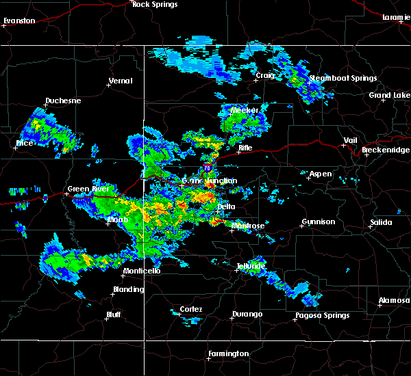
| 6/6/2020 12:16 PM MDT |
 At 1215 pm mdt, severe thunderstorms were located along a line extending from 15 miles northwest of de beque to 11 miles north of cedaredge to near olathe, moving northeast at 70 mph (trained weather spotters). Hazards include 70 mph wind gusts. Expect considerable tree damage. damage is likely to mobile homes, roofs, and outbuildings. locations impacted include, montrose, delta, orchard city, palisade, cedaredge, olathe, parachute, hotchkiss, collbran, de beque, crawford, mesa, battlement mesa, cameo, molina, austin, skyway, lazear, cory and plateau city. this includes the following highways, interstate 70 in colorado between mile markers 38 and 89. u. s. highway 50 in colorado between mile markers 61 and 91. colorado 65 between mile markers 1 and 61. colorado 90 mile marker 82 and near mile marker 88. colorado 92 between mile markers 1 and 31. Colorado 133 between mile markers 1 and 7. At 1215 pm mdt, severe thunderstorms were located along a line extending from 15 miles northwest of de beque to 11 miles north of cedaredge to near olathe, moving northeast at 70 mph (trained weather spotters). Hazards include 70 mph wind gusts. Expect considerable tree damage. damage is likely to mobile homes, roofs, and outbuildings. locations impacted include, montrose, delta, orchard city, palisade, cedaredge, olathe, parachute, hotchkiss, collbran, de beque, crawford, mesa, battlement mesa, cameo, molina, austin, skyway, lazear, cory and plateau city. this includes the following highways, interstate 70 in colorado between mile markers 38 and 89. u. s. highway 50 in colorado between mile markers 61 and 91. colorado 65 between mile markers 1 and 61. colorado 90 mile marker 82 and near mile marker 88. colorado 92 between mile markers 1 and 31. Colorado 133 between mile markers 1 and 7.
|
| 6/6/2020 11:59 AM MDT |
 At 1159 am mdt, severe thunderstorms were located along a line extending from 9 miles northeast of fruita to 6 miles northwest of delta to 13 miles west of montrose, moving northeast at 70 mph (trained weather spotters). Hazards include 70 mph wind gusts and penny size hail. Expect considerable tree damage. Damage is likely to mobile homes, roofs, and outbuildings. At 1159 am mdt, severe thunderstorms were located along a line extending from 9 miles northeast of fruita to 6 miles northwest of delta to 13 miles west of montrose, moving northeast at 70 mph (trained weather spotters). Hazards include 70 mph wind gusts and penny size hail. Expect considerable tree damage. Damage is likely to mobile homes, roofs, and outbuildings.
|
| 7/17/2018 4:20 PM MDT |
 At 417 pm mdt, an outflow boundary associated with a line of decaying thunderstorms were located along a line extending from 7 miles north of palisade to 11 miles southeast of grand junction to 25 miles south of fruita, moving southeast at 60 mph (trained spotters reported. at 4:11 pm mdt, 70 mph wind gusts were measured at the grand junction regional airport with significantly reduced visibility in blowing dust). Hazards include 70 mph wind gusts. Expect considerable tree damage. Damage is likely to mobile homes, roofs, and outbuildings. At 417 pm mdt, an outflow boundary associated with a line of decaying thunderstorms were located along a line extending from 7 miles north of palisade to 11 miles southeast of grand junction to 25 miles south of fruita, moving southeast at 60 mph (trained spotters reported. at 4:11 pm mdt, 70 mph wind gusts were measured at the grand junction regional airport with significantly reduced visibility in blowing dust). Hazards include 70 mph wind gusts. Expect considerable tree damage. Damage is likely to mobile homes, roofs, and outbuildings.
|
| 7/8/2015 7:24 PM MDT |
 The severe thunderstorm warning for northeastern delta and northeastern mesa counties will expire at 730 pm mdt, the storm which prompted the warning has weakened below severe limits, and no longer pose an immediate threat to life or property. therefore the warning will be allowed to expire. The severe thunderstorm warning for northeastern delta and northeastern mesa counties will expire at 730 pm mdt, the storm which prompted the warning has weakened below severe limits, and no longer pose an immediate threat to life or property. therefore the warning will be allowed to expire.
|
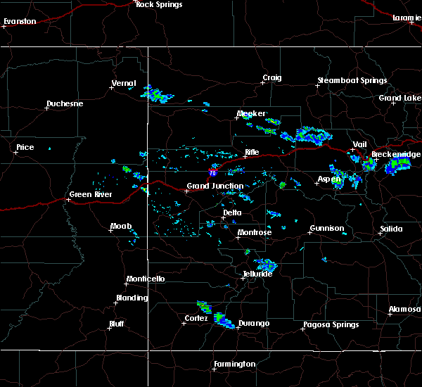
| 7/8/2015 7:07 PM MDT |
 At 705 pm mdt, a severe thunderstorm was located 8 miles north of cedaredge, or 36 miles east of grand junction, moving east at 35 mph (radar indicated). Hazards include quarter size hail with very heavy rain. damage to vehicles is expected At 705 pm mdt, a severe thunderstorm was located 8 miles north of cedaredge, or 36 miles east of grand junction, moving east at 35 mph (radar indicated). Hazards include quarter size hail with very heavy rain. damage to vehicles is expected
|


Connect with Interactive Hail Maps