

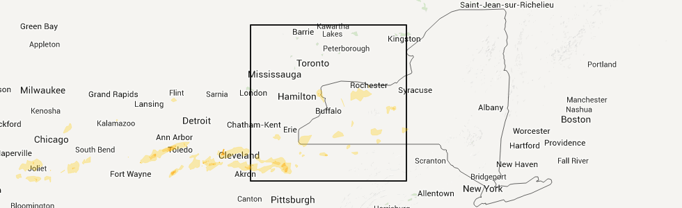
Hail Map for Churchville, NY
The Churchville, NY area has had 0 reports of on-the-ground hail by trained spotters, and has been under severe weather warnings 2 times during the past 12 months. Doppler radar has detected hail at or near Churchville, NY on 5 occasions.
| Name: | Churchville, NY |
| Where Located: | 52.7 miles ENE of Buffalo, NY |
| Map: | Google Map for Churchville, NY |
| Population: | 1961 |
| Housing Units: | 851 |
| More Info: | Search Google for Churchville, NY |
5
The Top Recent Hail Date for Churchville, NY is Sunday, May 29, 2011 (1st out of 5)
Hail and Wind Damage Spotted near Churchville, NY
| Date / Time | Report Details |
|---|---|
| 7/20/2023 9:22 PM EDT |
 At 921 pm edt, severe thunderstorms were located along a line extending from near brockport to near lima to dansville, moving northeast at 45 mph (radar indicated). Hazards include 60 mph wind gusts. Expect damage to trees and power lines. locations impacted include, rochester, greece, irondequoit, chili, canandaigua, brockport, east rochester, hilton, webster, and fairport. this includes the following highways, interstate 390 between exits 4 and 5, and between exits 8 and 12. interstate 90 between exits 44 and 46. hail threat, radar indicated max hail size, <. 75 in wind threat, radar indicated max wind gust, 60 mph. At 921 pm edt, severe thunderstorms were located along a line extending from near brockport to near lima to dansville, moving northeast at 45 mph (radar indicated). Hazards include 60 mph wind gusts. Expect damage to trees and power lines. locations impacted include, rochester, greece, irondequoit, chili, canandaigua, brockport, east rochester, hilton, webster, and fairport. this includes the following highways, interstate 390 between exits 4 and 5, and between exits 8 and 12. interstate 90 between exits 44 and 46. hail threat, radar indicated max hail size, <. 75 in wind threat, radar indicated max wind gust, 60 mph.
|
| 7/20/2023 8:46 PM EDT |
 At 845 pm edt, severe thunderstorms were located along a line extending from near oakfield to 7 miles south of belfast, moving northeast at 60 mph (radar indicated). Hazards include 60 mph wind gusts. Expect damage to trees and power lines. This storm has a history of producing wind damage across western new york. At 845 pm edt, severe thunderstorms were located along a line extending from near oakfield to 7 miles south of belfast, moving northeast at 60 mph (radar indicated). Hazards include 60 mph wind gusts. Expect damage to trees and power lines. This storm has a history of producing wind damage across western new york.
|
| 4/16/2023 9:27 PM EDT |
 The severe thunderstorm warning for orleans, monroe and eastern genesee counties will expire at 930 pm edt, the storms which prompted the warning have weakened below severe limits, and no longer pose an immediate threat to life or property. therefore, the warning will be allowed to expire. The severe thunderstorm warning for orleans, monroe and eastern genesee counties will expire at 930 pm edt, the storms which prompted the warning have weakened below severe limits, and no longer pose an immediate threat to life or property. therefore, the warning will be allowed to expire.
|
| 4/16/2023 9:07 PM EDT |
 At 906 pm edt, strong winds from earlier severe thunderstorms were located along a line extending from near lakeside beach state park to near byron to near batavia, moving northeast at 30 mph (radar indicated). Hazards include 60 mph wind gusts. Expect damage to trees and power lines. locations impacted include, rochester, greece, irondequoit, chili, batavia, brockport, medina, albion, hilton and brighton. this includes interstate 90 between exits 47 and 48. hail threat, radar indicated max hail size, <. 75 in wind threat, radar indicated max wind gust, 60 mph. At 906 pm edt, strong winds from earlier severe thunderstorms were located along a line extending from near lakeside beach state park to near byron to near batavia, moving northeast at 30 mph (radar indicated). Hazards include 60 mph wind gusts. Expect damage to trees and power lines. locations impacted include, rochester, greece, irondequoit, chili, batavia, brockport, medina, albion, hilton and brighton. this includes interstate 90 between exits 47 and 48. hail threat, radar indicated max hail size, <. 75 in wind threat, radar indicated max wind gust, 60 mph.
|
| 4/16/2023 8:35 PM EDT |
 At 834 pm edt, severe thunderstorms were located along a line extending from near lockport to 6 miles northeast of akron to darien lakes state park, moving northeast at 50 mph (radar indicated). Hazards include 60 mph wind gusts. expect damage to trees and power lines At 834 pm edt, severe thunderstorms were located along a line extending from near lockport to 6 miles northeast of akron to darien lakes state park, moving northeast at 50 mph (radar indicated). Hazards include 60 mph wind gusts. expect damage to trees and power lines
|
| 4/1/2023 2:52 PM EDT |
 At 250 pm edt, severe thunderstorms were located along a line extending from near medina to near houghton to marshburg, moving east at 70 mph (radar indicated). Hazards include 60 mph wind gusts and penny size hail. expect damage to trees and power lines At 250 pm edt, severe thunderstorms were located along a line extending from near medina to near houghton to marshburg, moving east at 70 mph (radar indicated). Hazards include 60 mph wind gusts and penny size hail. expect damage to trees and power lines
|
| 11/6/2022 2:34 AM EDT |
 At 133 am est, a severe thunderstorm was located near byron, or 7 miles southwest of brockport, moving northeast at 55 mph. an additional severe thunderstorm was north of brockport moving toward hilton (radar indicated). Hazards include 60 mph wind gusts. Expect damage to trees and power lines. locations impacted include, rochester, greece, chili, batavia, brockport, albion, hilton, hamlin beach state park, gates-north gates and spencerport. this includes interstate 90 between exits 47 and 48. hail threat, radar indicated max hail size, <. 75 in wind threat, radar indicated max wind gust, 60 mph. At 133 am est, a severe thunderstorm was located near byron, or 7 miles southwest of brockport, moving northeast at 55 mph. an additional severe thunderstorm was north of brockport moving toward hilton (radar indicated). Hazards include 60 mph wind gusts. Expect damage to trees and power lines. locations impacted include, rochester, greece, chili, batavia, brockport, albion, hilton, hamlin beach state park, gates-north gates and spencerport. this includes interstate 90 between exits 47 and 48. hail threat, radar indicated max hail size, <. 75 in wind threat, radar indicated max wind gust, 60 mph.
|
| 11/6/2022 2:20 AM EDT |
 At 119 am est, a severe thunderstorm was located over oakfield, or near batavia, moving northeast at 55 mph. an additional severe storm was located near albion and clarendon (radar indicated). Hazards include 60 mph wind gusts. expect damage to trees and power lines At 119 am est, a severe thunderstorm was located over oakfield, or near batavia, moving northeast at 55 mph. an additional severe storm was located near albion and clarendon (radar indicated). Hazards include 60 mph wind gusts. expect damage to trees and power lines
|
| 9/22/2022 12:09 AM EDT |
 At 1208 am edt, a severe thunderstorm was located near medina, moving east at 45 mph (radar indicated). Hazards include 60 mph wind gusts and penny size hail. Expect damage to trees and power lines. locations impacted include, greece, chili, brockport, medina, albion, hilton, hamlin beach state park, gates-north gates, spencerport and churchville. hail threat, radar indicated max hail size, 0. 75 in wind threat, radar indicated max wind gust, 60 mph. At 1208 am edt, a severe thunderstorm was located near medina, moving east at 45 mph (radar indicated). Hazards include 60 mph wind gusts and penny size hail. Expect damage to trees and power lines. locations impacted include, greece, chili, brockport, medina, albion, hilton, hamlin beach state park, gates-north gates, spencerport and churchville. hail threat, radar indicated max hail size, 0. 75 in wind threat, radar indicated max wind gust, 60 mph.
|
| 9/21/2022 11:45 PM EDT |
 At 1144 pm edt, a severe thunderstorm was located over newfane, or 7 miles north of lockport, moving east at 45 mph (radar indicated). Hazards include 60 mph wind gusts and quarter size hail. Minor damage to vehicles is possible. Expect wind damage to trees and power lines. At 1144 pm edt, a severe thunderstorm was located over newfane, or 7 miles north of lockport, moving east at 45 mph (radar indicated). Hazards include 60 mph wind gusts and quarter size hail. Minor damage to vehicles is possible. Expect wind damage to trees and power lines.
|
| 6/16/2022 4:30 PM EDT |
 At 429 pm edt, a severe thunderstorm was located over hilton, moving east at 55 mph (radar indicated). Hazards include 60 mph wind gusts and half dollar size hail. Minor damage to vehicles is possible. expect wind damage to trees and power lines. locations impacted include, rochester, greece, irondequoit, chili, brockport, east rochester, hilton, webster, fairport and brighton. this includes interstate 390 near exit 12. hail threat, radar indicated max hail size, 1. 25 in wind threat, radar indicated max wind gust, 60 mph. At 429 pm edt, a severe thunderstorm was located over hilton, moving east at 55 mph (radar indicated). Hazards include 60 mph wind gusts and half dollar size hail. Minor damage to vehicles is possible. expect wind damage to trees and power lines. locations impacted include, rochester, greece, irondequoit, chili, brockport, east rochester, hilton, webster, fairport and brighton. this includes interstate 390 near exit 12. hail threat, radar indicated max hail size, 1. 25 in wind threat, radar indicated max wind gust, 60 mph.
|
| 6/16/2022 4:07 PM EDT |
 At 407 pm edt, a severe thunderstorm was located over albion, moving east at 55 mph (radar indicated). Hazards include 60 mph wind gusts and half dollar size hail. Minor damage to vehicles is possible. Expect wind damage to trees and power lines. At 407 pm edt, a severe thunderstorm was located over albion, moving east at 55 mph (radar indicated). Hazards include 60 mph wind gusts and half dollar size hail. Minor damage to vehicles is possible. Expect wind damage to trees and power lines.
|
| 4/25/2022 7:08 PM EDT |
 At 707 pm edt, severe thunderstorms were located along a line extending from near holley to near mount morris, moving northeast at 40 mph (radar indicated). Hazards include 70 mph wind gusts and penny size hail. Expect considerable tree damage. Damage is likely to mobile homes, roofs, and outbuildings. At 707 pm edt, severe thunderstorms were located along a line extending from near holley to near mount morris, moving northeast at 40 mph (radar indicated). Hazards include 70 mph wind gusts and penny size hail. Expect considerable tree damage. Damage is likely to mobile homes, roofs, and outbuildings.
|
| 4/25/2022 6:49 PM EDT |
 At 648 pm edt, severe thunderstorms were located along a line extending from near medina to near varysburg, moving northeast at 50 mph (radar indicated). Hazards include 60 mph wind gusts. Expect damage to trees and power lines. locations impacted include, batavia, brockport, medina, albion, le roy, attica, pavilion, byron, caledonia and churchville. This includes interstate 90 between exits 48 and 47. At 648 pm edt, severe thunderstorms were located along a line extending from near medina to near varysburg, moving northeast at 50 mph (radar indicated). Hazards include 60 mph wind gusts. Expect damage to trees and power lines. locations impacted include, batavia, brockport, medina, albion, le roy, attica, pavilion, byron, caledonia and churchville. This includes interstate 90 between exits 48 and 47.
|
| 4/25/2022 6:34 PM EDT |
 At 633 pm edt, severe thunderstorms were located along a line extending from middleport to 6 miles southeast of wales center, moving northeast at 55 mph (radar indicated). Hazards include 60 mph wind gusts. expect damage to trees and power lines At 633 pm edt, severe thunderstorms were located along a line extending from middleport to 6 miles southeast of wales center, moving northeast at 55 mph (radar indicated). Hazards include 60 mph wind gusts. expect damage to trees and power lines
|
| 8/11/2021 8:22 AM EDT |
 At 821 am edt, a severe thunderstorm was located over churchville, or near chili, moving east at 30 mph (radar indicated). Hazards include 60 mph wind gusts. Expect damage to trees and power lines. locations impacted include, rochester, greece, irondequoit, chili, brockport, east rochester, hilton, brighton, gates-north gates and henrietta. this includes the following highways, interstate 390 near exit 12. interstate 90 near exit 46. hail threat, radar indicated max hail size, <. 75 in wind threat, radar indicated max wind gust, 60 mph. At 821 am edt, a severe thunderstorm was located over churchville, or near chili, moving east at 30 mph (radar indicated). Hazards include 60 mph wind gusts. Expect damage to trees and power lines. locations impacted include, rochester, greece, irondequoit, chili, brockport, east rochester, hilton, brighton, gates-north gates and henrietta. this includes the following highways, interstate 390 near exit 12. interstate 90 near exit 46. hail threat, radar indicated max hail size, <. 75 in wind threat, radar indicated max wind gust, 60 mph.
|
| 8/11/2021 8:10 AM EDT |
 At 810 am edt, a severe thunderstorm was located near byron, or 7 miles east of batavia, moving east at 30 mph (radar indicated). Hazards include 60 mph wind gusts. Expect damage to trees and power lines. locations impacted include, rochester, greece, irondequoit, chili, batavia, brockport, east rochester, hilton, brighton and gates-north gates. this includes the following highways, interstate 390 between exits 11 and 12. interstate 90 between exits 48 and 45. hail threat, radar indicated max hail size, <. 75 in wind threat, radar indicated max wind gust, 60 mph. At 810 am edt, a severe thunderstorm was located near byron, or 7 miles east of batavia, moving east at 30 mph (radar indicated). Hazards include 60 mph wind gusts. Expect damage to trees and power lines. locations impacted include, rochester, greece, irondequoit, chili, batavia, brockport, east rochester, hilton, brighton and gates-north gates. this includes the following highways, interstate 390 between exits 11 and 12. interstate 90 between exits 48 and 45. hail threat, radar indicated max hail size, <. 75 in wind threat, radar indicated max wind gust, 60 mph.
|
| 8/11/2021 7:46 AM EDT |
 At 746 am edt, a severe thunderstorm was located near oakfield, or near batavia, moving east at 30 mph (radar indicated). Hazards include 60 mph wind gusts. expect damage to trees and power lines At 746 am edt, a severe thunderstorm was located near oakfield, or near batavia, moving east at 30 mph (radar indicated). Hazards include 60 mph wind gusts. expect damage to trees and power lines
|
| 7/13/2021 7:19 PM EDT | Trees and wires down in the wheatland are in monroe county NY, 4.2 miles NNW of Churchville, NY |
| 7/13/2021 7:15 PM EDT |
 At 715 pm edt, severe thunderstorms were located along a line extending from near holley to near caledonia, moving northeast at 40 mph (radar indicated). Hazards include 60 mph wind gusts and quarter size hail. Minor damage to vehicles is possible. Expect wind damage to roofs, siding, and trees. At 715 pm edt, severe thunderstorms were located along a line extending from near holley to near caledonia, moving northeast at 40 mph (radar indicated). Hazards include 60 mph wind gusts and quarter size hail. Minor damage to vehicles is possible. Expect wind damage to roofs, siding, and trees.
|
| 7/6/2021 11:53 AM EDT |
 At 1152 am edt, a severe thunderstorm was located over caledonia, or 9 miles southwest of chili, moving east at 40 mph (radar indicated). Hazards include 60 mph wind gusts. Expect damage to roofs, siding, and trees. locations impacted include, canandaigua, henrietta, le roy, avon, victor, honeoye falls, bristol, caledonia, lima and scottsville. this includes the following highways, interstate 390 between exits 9 and 12. Interstate 90 between exits 47 and 44. At 1152 am edt, a severe thunderstorm was located over caledonia, or 9 miles southwest of chili, moving east at 40 mph (radar indicated). Hazards include 60 mph wind gusts. Expect damage to roofs, siding, and trees. locations impacted include, canandaigua, henrietta, le roy, avon, victor, honeoye falls, bristol, caledonia, lima and scottsville. this includes the following highways, interstate 390 between exits 9 and 12. Interstate 90 between exits 47 and 44.
|
| 7/6/2021 11:32 AM EDT |
 At 1131 am edt, a severe thunderstorm was located near byron, or near batavia, moving east at 45 mph (radar indicated). Hazards include 60 mph wind gusts. expect damage to roofs, siding, and trees At 1131 am edt, a severe thunderstorm was located near byron, or near batavia, moving east at 45 mph (radar indicated). Hazards include 60 mph wind gusts. expect damage to roofs, siding, and trees
|
| 6/20/2021 9:39 PM EDT |
 At 938 pm edt, a severe thunderstorm was located over caledonia, or 9 miles south of chili, moving northeast at 30 mph (radar indicated). Hazards include 60 mph wind gusts and quarter size hail. Minor damage to vehicles is possible. expect wind damage to roofs, siding, and trees. locations impacted include, le roy, avon, honeoye falls, caledonia, scottsville, riga, rush, york, north chili and martin. This includes interstate 390 between exits 10 and 11. At 938 pm edt, a severe thunderstorm was located over caledonia, or 9 miles south of chili, moving northeast at 30 mph (radar indicated). Hazards include 60 mph wind gusts and quarter size hail. Minor damage to vehicles is possible. expect wind damage to roofs, siding, and trees. locations impacted include, le roy, avon, honeoye falls, caledonia, scottsville, riga, rush, york, north chili and martin. This includes interstate 390 between exits 10 and 11.
|
| 11/15/2020 4:32 PM EST |
 At 431 pm est, severe thunderstorms were located along a line extending from near rochester to 8 miles west of alfred, moving east at 55 mph (radar indicated). Hazards include 60 mph wind gusts. Expect damage to roofs, siding, and trees. locations impacted include, rochester, greece, irondequoit, chili, geneva, canandaigua, geneseo, east rochester, hilton, webster, mount morris, portageville, angelica, fillmore, and belmont. this includes the following highways, interstate 390 between exits 4 and 12. interstate 90 between exits 46 and 42. Interstate 86 between exits 29 and 33. At 431 pm est, severe thunderstorms were located along a line extending from near rochester to 8 miles west of alfred, moving east at 55 mph (radar indicated). Hazards include 60 mph wind gusts. Expect damage to roofs, siding, and trees. locations impacted include, rochester, greece, irondequoit, chili, geneva, canandaigua, geneseo, east rochester, hilton, webster, mount morris, portageville, angelica, fillmore, and belmont. this includes the following highways, interstate 390 between exits 4 and 12. interstate 90 between exits 46 and 42. Interstate 86 between exits 29 and 33.
|
| 11/15/2020 4:18 PM EST |
 At 417 pm est, severe thunderstorms were located along a line extending from hilton to near cuba, moving east at 65 mph (radar indicated). Hazards include 60 mph wind gusts. Expect damage to roofs, siding, and trees. locations impacted include, olean, brockport, hamlin beach state park, letchworth state park, le roy, perry, warsaw, pavilion, churchville and allegany. this includes the following highways, interstate 90 near exit 47. Interstate 86 between exits 24 and 28. At 417 pm est, severe thunderstorms were located along a line extending from hilton to near cuba, moving east at 65 mph (radar indicated). Hazards include 60 mph wind gusts. Expect damage to roofs, siding, and trees. locations impacted include, olean, brockport, hamlin beach state park, letchworth state park, le roy, perry, warsaw, pavilion, churchville and allegany. this includes the following highways, interstate 90 near exit 47. Interstate 86 between exits 24 and 28.
|
| 11/15/2020 4:01 PM EST |
 At 401 pm est, severe thunderstorms were located along a line extending from 6 miles northeast of point breeze to near salamanca, moving east at 65 mph (radar indicated). Hazards include 60 mph wind gusts. Expect damage to roofs, siding, and trees. locations impacted include, batavia, olean, brockport, albion, salamanca, hamlin beach state park, allegany state park, letchworth state park, le roy and perry. this includes the following highways, interstate 90 between exits 48 and 47. Interstate 86 between exits 21 and 28. At 401 pm est, severe thunderstorms were located along a line extending from 6 miles northeast of point breeze to near salamanca, moving east at 65 mph (radar indicated). Hazards include 60 mph wind gusts. Expect damage to roofs, siding, and trees. locations impacted include, batavia, olean, brockport, albion, salamanca, hamlin beach state park, allegany state park, letchworth state park, le roy and perry. this includes the following highways, interstate 90 between exits 48 and 47. Interstate 86 between exits 21 and 28.
|
| 11/15/2020 3:57 PM EST |
 At 355 pm est, severe thunderstorms were located along a line extending from near albion to 6 miles south of franklinville, moving east at 55 mph (radar indicated). Hazards include 60 mph wind gusts. expect damage to roofs, siding, and trees At 355 pm est, severe thunderstorms were located along a line extending from near albion to 6 miles south of franklinville, moving east at 55 mph (radar indicated). Hazards include 60 mph wind gusts. expect damage to roofs, siding, and trees
|
| 11/15/2020 3:44 PM EST |
 At 342 pm est, severe thunderstorms were located along a line extending from 8 miles west of waterport to 10 miles east of frewsburg, moving east at 65 mph (radar indicated). Hazards include 70 mph wind gusts. Expect considerable tree damage. damage is likely to mobile homes, roofs, and outbuildings. locations impacted include, medina, lyndonville, albion, corfu, oakfield, batavia, alden, east aurora, holland, attica, warsaw, springville, little valley, ellicottville, and randolph. this includes the following highways, interstate 90 between exits 48a and 47. Interstate 86 between exits 14 and 28. At 342 pm est, severe thunderstorms were located along a line extending from 8 miles west of waterport to 10 miles east of frewsburg, moving east at 65 mph (radar indicated). Hazards include 70 mph wind gusts. Expect considerable tree damage. damage is likely to mobile homes, roofs, and outbuildings. locations impacted include, medina, lyndonville, albion, corfu, oakfield, batavia, alden, east aurora, holland, attica, warsaw, springville, little valley, ellicottville, and randolph. this includes the following highways, interstate 90 between exits 48a and 47. Interstate 86 between exits 14 and 28.
|
| 11/15/2020 3:24 PM EST |
 At 323 pm est, severe thunderstorms were located along a line extending from 6 miles west of newfane to 6 miles south of jamestown west, moving east at 65 mph (radar indicated). Hazards include 70 mph wind gusts. Expect considerable tree damage. Damage is likely to mobile homes, roofs, and outbuildings. At 323 pm est, severe thunderstorms were located along a line extending from 6 miles west of newfane to 6 miles south of jamestown west, moving east at 65 mph (radar indicated). Hazards include 70 mph wind gusts. Expect considerable tree damage. Damage is likely to mobile homes, roofs, and outbuildings.
|
| 8/25/2020 3:06 AM EDT |
 At 305 am edt, a severe thunderstorm was located over brockport, moving east at 35 mph (radar indicated). Hazards include 60 mph wind gusts. Expect damage to roofs, siding, and trees. Locations impacted include, brockport, medina, albion, hilton, hamlin beach state park, spencerport, churchville, middleport, holley and waterport. At 305 am edt, a severe thunderstorm was located over brockport, moving east at 35 mph (radar indicated). Hazards include 60 mph wind gusts. Expect damage to roofs, siding, and trees. Locations impacted include, brockport, medina, albion, hilton, hamlin beach state park, spencerport, churchville, middleport, holley and waterport.
|
| 8/25/2020 2:27 AM EDT |
 At 225 am edt, a severe thunderstorm was located near medina, moving east at 35 mph (radar indicated). Hazards include 60 mph wind gusts. expect damage to roofs, siding, and trees At 225 am edt, a severe thunderstorm was located near medina, moving east at 35 mph (radar indicated). Hazards include 60 mph wind gusts. expect damage to roofs, siding, and trees
|
| 7/29/2020 7:21 PM EDT |
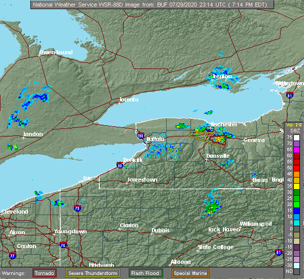 At 721 pm edt, a severe thunderstorm was located near scottsville, or near chili, moving east at 40 mph (radar indicated). Hazards include 60 mph wind gusts. Expect damage to roofs, siding, and trees. locations impacted include, henrietta, victor, honeoye falls, scottsville, churchville, bloomfield, farmington, mendon, riga and east bloomfield. this includes the following highways, interstate 390 between exits 11 and 12. Interstate 90 between exits 46 and 44. At 721 pm edt, a severe thunderstorm was located near scottsville, or near chili, moving east at 40 mph (radar indicated). Hazards include 60 mph wind gusts. Expect damage to roofs, siding, and trees. locations impacted include, henrietta, victor, honeoye falls, scottsville, churchville, bloomfield, farmington, mendon, riga and east bloomfield. this includes the following highways, interstate 390 between exits 11 and 12. Interstate 90 between exits 46 and 44.
|
| 7/29/2020 7:08 PM EDT |
 At 708 pm edt, a severe thunderstorm was located near byron, or 10 miles south of brockport, moving east at 30 mph (radar indicated). Hazards include 60 mph wind gusts and quarter size hail. Minor damage to vehicles is possible. expect wind damage to roofs, siding, and trees. locations impacted include, henrietta, victor, honeoye falls, bristol, caledonia, lima, scottsville, churchville, bloomfield and farmington. this includes the following highways, interstate 390 between exits 11 and 12. Interstate 90 between exits 47 and 44. At 708 pm edt, a severe thunderstorm was located near byron, or 10 miles south of brockport, moving east at 30 mph (radar indicated). Hazards include 60 mph wind gusts and quarter size hail. Minor damage to vehicles is possible. expect wind damage to roofs, siding, and trees. locations impacted include, henrietta, victor, honeoye falls, bristol, caledonia, lima, scottsville, churchville, bloomfield and farmington. this includes the following highways, interstate 390 between exits 11 and 12. Interstate 90 between exits 47 and 44.
|
| 7/29/2020 6:37 PM EDT |
 At 637 pm edt, a severe thunderstorm was located near le roy, or 11 miles east of batavia, moving east at 25 mph (radar indicated). Hazards include 60 mph wind gusts and penny size hail. expect damage to roofs, siding, and trees At 637 pm edt, a severe thunderstorm was located near le roy, or 11 miles east of batavia, moving east at 25 mph (radar indicated). Hazards include 60 mph wind gusts and penny size hail. expect damage to roofs, siding, and trees
|
| 6/11/2020 12:27 AM EDT |
 The severe thunderstorm warning for northeastern wyoming, northern livingston, eastern orleans, monroe, eastern genesee and northwestern ontario counties will expire at 1230 am edt, the storm which prompted the warning has weakened below severe limits, and no longer poses an immediate threat to life or property. therefore, the warning will be allowed to expire. however gusty winds and heavy rain are still possible with this thunderstorm. a severe thunderstorm watch remains in effect until 200 am edt for western new york. The severe thunderstorm warning for northeastern wyoming, northern livingston, eastern orleans, monroe, eastern genesee and northwestern ontario counties will expire at 1230 am edt, the storm which prompted the warning has weakened below severe limits, and no longer poses an immediate threat to life or property. therefore, the warning will be allowed to expire. however gusty winds and heavy rain are still possible with this thunderstorm. a severe thunderstorm watch remains in effect until 200 am edt for western new york.
|
| 6/10/2020 11:54 PM EDT |
 At 1154 pm edt, a severe thunderstorm was located over caledonia, or 7 miles southwest of chili, moving east at 50 mph (radar indicated). Hazards include 60 mph wind gusts. Expect damage to roofs, siding, and trees. locations impacted include, rochester, greece, irondequoit, chili, brockport, geneseo, east rochester, hilton, webster and fairport. this includes the following highways, interstate 390 between exits 8 and 12. Interstate 90 between exits 47 and 45. At 1154 pm edt, a severe thunderstorm was located over caledonia, or 7 miles southwest of chili, moving east at 50 mph (radar indicated). Hazards include 60 mph wind gusts. Expect damage to roofs, siding, and trees. locations impacted include, rochester, greece, irondequoit, chili, brockport, geneseo, east rochester, hilton, webster and fairport. this includes the following highways, interstate 390 between exits 8 and 12. Interstate 90 between exits 47 and 45.
|
| 6/10/2020 11:26 PM EDT |
 At 1125 pm edt, a severe thunderstorm was located over pembroke, or 7 miles north of darien lakes state park, moving east at 50 mph (radar indicated). Hazards include 60 mph wind gusts. expect damage to roofs, siding, and trees At 1125 pm edt, a severe thunderstorm was located over pembroke, or 7 miles north of darien lakes state park, moving east at 50 mph (radar indicated). Hazards include 60 mph wind gusts. expect damage to roofs, siding, and trees
|
| 6/2/2020 11:31 PM EDT |
 At 1130 pm edt, a severe thunderstorm was located near honeoye falls, or 12 miles southeast of chili, moving southeast at 50 mph. another severe thunderstorm was located near leroy, moving southeast at 50 mph (radar indicated). Hazards include 60 mph wind gusts and quarter size hail. Minor damage to vehicles is possible. expect wind damage to roofs, siding, and trees. locations impacted include, rochester, chili, brockport, brighton, henrietta, le roy, spencerport, avon, victor and honeoye falls. this includes the following highways, interstate 390 between exits 8 and 12. Interstate 90 between exits 47 and 44. At 1130 pm edt, a severe thunderstorm was located near honeoye falls, or 12 miles southeast of chili, moving southeast at 50 mph. another severe thunderstorm was located near leroy, moving southeast at 50 mph (radar indicated). Hazards include 60 mph wind gusts and quarter size hail. Minor damage to vehicles is possible. expect wind damage to roofs, siding, and trees. locations impacted include, rochester, chili, brockport, brighton, henrietta, le roy, spencerport, avon, victor and honeoye falls. this includes the following highways, interstate 390 between exits 8 and 12. Interstate 90 between exits 47 and 44.
|
| 6/2/2020 11:06 PM EDT |
 At 1106 pm edt, a severe thunderstorm was located near churchville, or near brockport, moving southeast at 55 mph (radar indicated). Hazards include 60 mph wind gusts and half dollar size hail. Minor damage to vehicles is possible. Expect wind damage to roofs, siding, and trees. At 1106 pm edt, a severe thunderstorm was located near churchville, or near brockport, moving southeast at 55 mph (radar indicated). Hazards include 60 mph wind gusts and half dollar size hail. Minor damage to vehicles is possible. Expect wind damage to roofs, siding, and trees.
|
| 5/29/2020 2:03 PM EDT |
 At 203 pm edt, a severe thunderstorm was located over gates-north gates, moving northeast at 45 mph (radar indicated). Hazards include 60 mph wind gusts and penny size hail. Expect damage to roofs, siding, and trees. Locations impacted include, rochester, greece, irondequoit, chili, brockport, east rochester, hilton, webster, brighton and gates-north gates. At 203 pm edt, a severe thunderstorm was located over gates-north gates, moving northeast at 45 mph (radar indicated). Hazards include 60 mph wind gusts and penny size hail. Expect damage to roofs, siding, and trees. Locations impacted include, rochester, greece, irondequoit, chili, brockport, east rochester, hilton, webster, brighton and gates-north gates.
|
| 5/29/2020 1:43 PM EDT |
 At 143 pm edt, a severe thunderstorm was located near churchville, or 9 miles south of brockport, moving northeast at 45 mph (radar indicated). Hazards include 60 mph wind gusts and penny size hail. expect damage to roofs, siding, and trees At 143 pm edt, a severe thunderstorm was located near churchville, or 9 miles south of brockport, moving northeast at 45 mph (radar indicated). Hazards include 60 mph wind gusts and penny size hail. expect damage to roofs, siding, and trees
|
| 3/29/2020 3:00 PM EDT |
 At 259 pm edt, severe thunderstorms were located along a line extending from hamlin beach state park to near churchville, moving east at 50 mph (radar indicated). Hazards include 60 mph wind gusts and nickel size hail. Expect damage to roofs, siding, and trees. locations impacted include, brockport, spencerport, rochester, greece, irondequoit, chili, brockport, east rochester, hilton, webster, and brighton. this includes the following highways, interstate 390 between exits 11 and 12. Interstate 90 between exits 47 and 45. At 259 pm edt, severe thunderstorms were located along a line extending from hamlin beach state park to near churchville, moving east at 50 mph (radar indicated). Hazards include 60 mph wind gusts and nickel size hail. Expect damage to roofs, siding, and trees. locations impacted include, brockport, spencerport, rochester, greece, irondequoit, chili, brockport, east rochester, hilton, webster, and brighton. this includes the following highways, interstate 390 between exits 11 and 12. Interstate 90 between exits 47 and 45.
|
| 3/29/2020 2:41 PM EDT |
 At 241 pm edt, severe thunderstorms were located along a line extending from near albion to near batavia, moving east at 50 mph (radar indicated). Hazards include 60 mph wind gusts and nickel size hail. expect damage to roofs, siding, and trees At 241 pm edt, severe thunderstorms were located along a line extending from near albion to near batavia, moving east at 50 mph (radar indicated). Hazards include 60 mph wind gusts and nickel size hail. expect damage to roofs, siding, and trees
|
| 9/23/2019 7:25 PM EDT |
 At 724 pm edt, a severe thunderstorm was located over spencerport, or near greece, moving east at 45 mph (radar indicated). Hazards include 60 mph wind gusts. Expect damage to roofs, siding, and trees. Locations impacted include, rochester, greece, chili, brockport, gates, spencerport, churchville, charlotte and north chili. At 724 pm edt, a severe thunderstorm was located over spencerport, or near greece, moving east at 45 mph (radar indicated). Hazards include 60 mph wind gusts. Expect damage to roofs, siding, and trees. Locations impacted include, rochester, greece, chili, brockport, gates, spencerport, churchville, charlotte and north chili.
|
| 9/23/2019 7:01 PM EDT |
 At 700 pm edt, a severe thunderstorm was located near albion, moving east at 50 mph (radar indicated). Hazards include 60 mph wind gusts and nickel size hail. expect damage to roofs, siding, and trees At 700 pm edt, a severe thunderstorm was located near albion, moving east at 50 mph (radar indicated). Hazards include 60 mph wind gusts and nickel size hail. expect damage to roofs, siding, and trees
|
| 8/8/2019 12:13 PM EDT |
 At 1213 pm edt, severe thunderstorms were located along a line extending from near hilton to near chili to near pavilion, moving east at 40 mph (radar indicated). Hazards include 60 mph wind gusts. Expect damage to roofs, siding, and trees. locations impacted include, rochester, greece, irondequoit, chili, brockport, east rochester, hilton, webster, fairport and brighton. this includes the following highways, interstate 390 between exits 10 and 12. Interstate 90 between exits 47 and 46. At 1213 pm edt, severe thunderstorms were located along a line extending from near hilton to near chili to near pavilion, moving east at 40 mph (radar indicated). Hazards include 60 mph wind gusts. Expect damage to roofs, siding, and trees. locations impacted include, rochester, greece, irondequoit, chili, brockport, east rochester, hilton, webster, fairport and brighton. this includes the following highways, interstate 390 between exits 10 and 12. Interstate 90 between exits 47 and 46.
|
| 8/8/2019 11:50 AM EDT |
 At 1149 am edt, severe thunderstorms were located along a line extending from near hamlin beach state park to byron to near attica, moving east at 35 mph (radar indicated). Hazards include 60 mph wind gusts. expect damage to roofs, siding, and trees At 1149 am edt, severe thunderstorms were located along a line extending from near hamlin beach state park to byron to near attica, moving east at 35 mph (radar indicated). Hazards include 60 mph wind gusts. expect damage to roofs, siding, and trees
|
| 7/20/2019 11:38 PM EDT |
 At 1137 pm edt, a severe thunderstorm was located over brighton, moving east at 55 mph (radar indicated). Hazards include 60 mph wind gusts. Expect damage to roofs, siding, and trees. locations impacted include, rochester, greece, irondequoit, chili, east rochester, webster, fairport, brighton, gates-north gates and henrietta. this includes the following highways, interstate 390 between exits 11 and 12. Interstate 90 near exit 46. At 1137 pm edt, a severe thunderstorm was located over brighton, moving east at 55 mph (radar indicated). Hazards include 60 mph wind gusts. Expect damage to roofs, siding, and trees. locations impacted include, rochester, greece, irondequoit, chili, east rochester, webster, fairport, brighton, gates-north gates and henrietta. this includes the following highways, interstate 390 between exits 11 and 12. Interstate 90 near exit 46.
|
| 7/20/2019 11:02 PM EDT |
 At 1101 pm edt, a severe thunderstorm was located near medina, moving east at 50 mph (radar indicated). Hazards include 60 mph wind gusts and penny size hail. expect damage to roofs, siding, and trees At 1101 pm edt, a severe thunderstorm was located near medina, moving east at 50 mph (radar indicated). Hazards include 60 mph wind gusts and penny size hail. expect damage to roofs, siding, and trees
|
| 7/19/2019 2:24 PM EDT |
 The severe thunderstorm warning for east central niagara, orleans, west central monroe and northern genesee counties will expire at 230 pm edt, the storms which prompted the warning have weakened below severe limits, and no longer pose an immediate threat to life or property. therefore, the warning will be allowed to expire. however gusty winds and heavy rain are still possible with these thunderstorms. The severe thunderstorm warning for east central niagara, orleans, west central monroe and northern genesee counties will expire at 230 pm edt, the storms which prompted the warning have weakened below severe limits, and no longer pose an immediate threat to life or property. therefore, the warning will be allowed to expire. however gusty winds and heavy rain are still possible with these thunderstorms.
|
| 7/19/2019 1:57 PM EDT |
 At 156 pm edt, severe thunderstorms were located along a line extending from near albion to near lockport, moving east at 35 mph (radar indicated). Hazards include 70 mph wind gusts and ping pong ball size hail. People and animals outdoors will be injured. expect hail damage to roofs, siding, windows, and vehicles. expect considerable tree damage. Wind damage is also likely to mobile homes, roofs, and outbuildings. At 156 pm edt, severe thunderstorms were located along a line extending from near albion to near lockport, moving east at 35 mph (radar indicated). Hazards include 70 mph wind gusts and ping pong ball size hail. People and animals outdoors will be injured. expect hail damage to roofs, siding, windows, and vehicles. expect considerable tree damage. Wind damage is also likely to mobile homes, roofs, and outbuildings.
|
| 9/21/2018 6:31 PM EDT |
 The national weather service in buffalo has issued a * severe thunderstorm warning for. southwestern wayne county in western new york. wyoming county in western new york. livingston county in western new york. Southern monroe county in western new york. The national weather service in buffalo has issued a * severe thunderstorm warning for. southwestern wayne county in western new york. wyoming county in western new york. livingston county in western new york. Southern monroe county in western new york.
|
| 9/3/2018 3:34 PM EDT |
 At 333 pm edt, a severe thunderstorm was located near medina, moving east at 35 mph (radar indicated). Hazards include 60 mph wind gusts. Expect damage to roofs, siding, and trees. Locations impacted include, brockport, medina, albion, byron, churchville, oakfield, holley and ridgeway. At 333 pm edt, a severe thunderstorm was located near medina, moving east at 35 mph (radar indicated). Hazards include 60 mph wind gusts. Expect damage to roofs, siding, and trees. Locations impacted include, brockport, medina, albion, byron, churchville, oakfield, holley and ridgeway.
|
| 9/3/2018 3:12 PM EDT |
 At 311 pm edt, a severe thunderstorm was located near middleport, or 7 miles west of medina, moving east at 35 mph (radar indicated). Hazards include 60 mph wind gusts. expect damage to roofs, siding, and trees At 311 pm edt, a severe thunderstorm was located near middleport, or 7 miles west of medina, moving east at 35 mph (radar indicated). Hazards include 60 mph wind gusts. expect damage to roofs, siding, and trees
|
| 5/4/2018 4:37 PM EDT |
 The severe thunderstorm warning for western wayne, southeastern orleans, monroe and eastern genesee counties will expire at 445 pm edt, the storm which prompted the warning has weakened below severe limits, and no longer pose an immediate threat to life or property. therefore the warning will be allowed to expire. however gusty winds are still possible with this thunderstorm. a severe thunderstorm watch remains in effect until 900 pm edt for western new york. The severe thunderstorm warning for western wayne, southeastern orleans, monroe and eastern genesee counties will expire at 445 pm edt, the storm which prompted the warning has weakened below severe limits, and no longer pose an immediate threat to life or property. therefore the warning will be allowed to expire. however gusty winds are still possible with this thunderstorm. a severe thunderstorm watch remains in effect until 900 pm edt for western new york.
|
| 5/4/2018 4:10 PM EDT |
 The national weather service in buffalo has issued a * severe thunderstorm warning for. western wayne county in western new york. southeastern orleans county in western new york. monroe county in western new york. Eastern genesee county in western new york. The national weather service in buffalo has issued a * severe thunderstorm warning for. western wayne county in western new york. southeastern orleans county in western new york. monroe county in western new york. Eastern genesee county in western new york.
|
| 10/15/2017 4:42 PM EDT |
 The severe thunderstorm warning for wyoming, northern cattaraugus, southeastern erie, eastern orleans, east central chautauqua, northwestern monroe and genesee counties will expire at 445 pm edt, the storms which prompted the warning have moved out of the area. therefore the warning will be allowed to expire. The severe thunderstorm warning for wyoming, northern cattaraugus, southeastern erie, eastern orleans, east central chautauqua, northwestern monroe and genesee counties will expire at 445 pm edt, the storms which prompted the warning have moved out of the area. therefore the warning will be allowed to expire.
|
| 10/15/2017 4:36 PM EDT |
 At 432 pm edt, severe thunderstorms were located along a line extending from near hilton to near pavilion to ashford hollow, moving east at 50 mph (radar indicated). Hazards include 60 mph wind gusts. expect wind damage to trees and power lines At 432 pm edt, severe thunderstorms were located along a line extending from near hilton to near pavilion to ashford hollow, moving east at 50 mph (radar indicated). Hazards include 60 mph wind gusts. expect wind damage to trees and power lines
|
| 10/15/2017 4:21 PM EDT |
 At 419 pm edt, severe thunderstorms were located along a line extending from near point breeze to near wales center to near gowanda, moving east at 60 mph (radar indicated). Hazards include 60 mph wind gusts. Expect wind damage to trees and power lines. locations impacted include, batavia, brockport, albion, hilton, darien lakes state park, hamlin beach state park, boston and le roy. This includes interstate 90 between exits 48 and 47. At 419 pm edt, severe thunderstorms were located along a line extending from near point breeze to near wales center to near gowanda, moving east at 60 mph (radar indicated). Hazards include 60 mph wind gusts. Expect wind damage to trees and power lines. locations impacted include, batavia, brockport, albion, hilton, darien lakes state park, hamlin beach state park, boston and le roy. This includes interstate 90 between exits 48 and 47.
|
| 10/15/2017 3:56 PM EDT |
 At 356 pm edt, severe thunderstorms were located along a line extending from near lakeside beach state park to north collins to 8 miles south of fredonia, moving southeast at 45 mph (radar indicated). Hazards include 60 mph wind gusts. expect wind damage to trees and power lines At 356 pm edt, severe thunderstorms were located along a line extending from near lakeside beach state park to north collins to 8 miles south of fredonia, moving southeast at 45 mph (radar indicated). Hazards include 60 mph wind gusts. expect wind damage to trees and power lines
|
| 9/4/2017 11:06 PM EDT |
 At 1105 pm edt, a severe thunderstorm was located over scottsville, or near chili, moving east at 60 mph (radar indicated). Hazards include 60 mph wind gusts. expect wind damage to trees and power lines At 1105 pm edt, a severe thunderstorm was located over scottsville, or near chili, moving east at 60 mph (radar indicated). Hazards include 60 mph wind gusts. expect wind damage to trees and power lines
|
| 8/22/2017 12:34 PM EDT |
 At 1234 pm edt, severe thunderstorms were located along a line extending from near batavia to near varysburg, moving northeast at 55 mph (radar indicated). Hazards include 60 mph wind gusts. expect wind damage to trees and power lines At 1234 pm edt, severe thunderstorms were located along a line extending from near batavia to near varysburg, moving northeast at 55 mph (radar indicated). Hazards include 60 mph wind gusts. expect wind damage to trees and power lines
|
| 8/1/2017 7:33 PM EDT |
 At 733 pm edt, a severe thunderstorm was located over spencerport, or near greece, moving northeast at 15 mph (radar indicated). Hazards include 60 mph wind gusts and quarter size hail. Minor damage to vehicles is possible. expect wind damage to trees and power lines. Locations impacted include, rochester, greece, chili, brighton, gates-north gates, spencerport, north chili and rochester international airport. At 733 pm edt, a severe thunderstorm was located over spencerport, or near greece, moving northeast at 15 mph (radar indicated). Hazards include 60 mph wind gusts and quarter size hail. Minor damage to vehicles is possible. expect wind damage to trees and power lines. Locations impacted include, rochester, greece, chili, brighton, gates-north gates, spencerport, north chili and rochester international airport.
|
| 8/1/2017 7:17 PM EDT |
 At 717 pm edt, a severe thunderstorm was located over churchville, or near chili, moving east at 15 mph (radar indicated). Hazards include 60 mph wind gusts and quarter size hail. Minor damage to vehicles is possible. Expect wind damage to trees and power lines. At 717 pm edt, a severe thunderstorm was located over churchville, or near chili, moving east at 15 mph (radar indicated). Hazards include 60 mph wind gusts and quarter size hail. Minor damage to vehicles is possible. Expect wind damage to trees and power lines.
|
| 7/20/2017 12:48 PM EDT |
 At 1247 pm edt, a severe thunderstorm was located over churchville, or near chili, moving east at 45 mph (radar indicated). Hazards include 60 mph wind gusts. Expect wind damage to trees and power lines. locations impacted include, rochester, greece, irondequoit, chili, batavia, canandaigua, brockport and geneseo. this includes the following highways, interstate 390 between exits 8 and 12. Interstate 90 between exits 48a and 43. At 1247 pm edt, a severe thunderstorm was located over churchville, or near chili, moving east at 45 mph (radar indicated). Hazards include 60 mph wind gusts. Expect wind damage to trees and power lines. locations impacted include, rochester, greece, irondequoit, chili, batavia, canandaigua, brockport and geneseo. this includes the following highways, interstate 390 between exits 8 and 12. Interstate 90 between exits 48a and 43.
|
| 7/20/2017 12:21 PM EDT |
 At 1221 pm edt, a severe thunderstorm was located near albion, moving east at 45 mph (radar indicated). Hazards include 60 mph wind gusts. expect wind damage to trees and power lines At 1221 pm edt, a severe thunderstorm was located near albion, moving east at 45 mph (radar indicated). Hazards include 60 mph wind gusts. expect wind damage to trees and power lines
|
| 6/26/2017 4:47 PM EDT |
 At 447 pm edt, a severe thunderstorm was located near attica, or 11 miles southeast of darien lakes state park, moving northeast at 30 mph (radar indicated). Hazards include 60 mph wind gusts and quarter size hail. Minor damage to vehicles is possible. Expect wind damage to trees and power lines. At 447 pm edt, a severe thunderstorm was located near attica, or 11 miles southeast of darien lakes state park, moving northeast at 30 mph (radar indicated). Hazards include 60 mph wind gusts and quarter size hail. Minor damage to vehicles is possible. Expect wind damage to trees and power lines.
|
| 6/18/2017 5:13 PM EDT |
 At 513 pm edt, severe thunderstorms were located along a line extending from spencerport to near caledonia, moving northeast at 45 mph (radar indicated). Hazards include 60 mph wind gusts. Expect wind damage to trees and power lines. locations impacted include, rochester, greece, chili, brighton, gates-north gates, le roy, spencerport and warsaw. this includes the following highways, interstate 390 between exits 10 and 12. Interstate 90 between exits 47 and 46. At 513 pm edt, severe thunderstorms were located along a line extending from spencerport to near caledonia, moving northeast at 45 mph (radar indicated). Hazards include 60 mph wind gusts. Expect wind damage to trees and power lines. locations impacted include, rochester, greece, chili, brighton, gates-north gates, le roy, spencerport and warsaw. this includes the following highways, interstate 390 between exits 10 and 12. Interstate 90 between exits 47 and 46.
|
| 6/18/2017 4:54 PM EDT |
 At 454 pm edt, a severe thunderstorm was located over pavilion, or 9 miles southeast of batavia, moving northeast at 35 mph (radar indicated). Hazards include 60 mph wind gusts. expect wind damage to trees and power lines At 454 pm edt, a severe thunderstorm was located over pavilion, or 9 miles southeast of batavia, moving northeast at 35 mph (radar indicated). Hazards include 60 mph wind gusts. expect wind damage to trees and power lines
|
| 6/15/2017 5:26 PM EDT |
 At 526 pm edt, a severe thunderstorm was located near byron, or near brockport, moving north at 10 mph (radar indicated). Hazards include 60 mph wind gusts and penny size hail. expect wind damage to trees and power lines At 526 pm edt, a severe thunderstorm was located near byron, or near brockport, moving north at 10 mph (radar indicated). Hazards include 60 mph wind gusts and penny size hail. expect wind damage to trees and power lines
|
| 6/15/2017 5:25 PM EDT |
 At 524 pm edt, a severe thunderstorm was located over churchville, or 7 miles southwest of chili, moving northeast at 20 mph (radar indicated). Hazards include 60 mph wind gusts and quarter size hail. Minor damage to vehicles is possible. expect wind damage to trees and power lines. Locations impacted include, chili, churchville, riga, bergen and north chili. At 524 pm edt, a severe thunderstorm was located over churchville, or 7 miles southwest of chili, moving northeast at 20 mph (radar indicated). Hazards include 60 mph wind gusts and quarter size hail. Minor damage to vehicles is possible. expect wind damage to trees and power lines. Locations impacted include, chili, churchville, riga, bergen and north chili.
|
| 6/15/2017 4:54 PM EDT |
 At 454 pm edt, a severe thunderstorm was located near le roy, or 8 miles southeast of batavia, moving northeast at 20 mph (radar indicated). Hazards include 60 mph wind gusts and quarter size hail. Minor damage to vehicles is possible. Expect wind damage to trees and power lines. At 454 pm edt, a severe thunderstorm was located near le roy, or 8 miles southeast of batavia, moving northeast at 20 mph (radar indicated). Hazards include 60 mph wind gusts and quarter size hail. Minor damage to vehicles is possible. Expect wind damage to trees and power lines.
|
| 5/1/2017 4:54 PM EDT |
 At 453 pm edt, severe thunderstorms were located along a line extending from near webster to near east rochester to near honeoye falls to near portageville, moving east at 40 mph (radar indicated). Hazards include 70 mph wind gusts. Expect considerable tree damage. damage is likely to mobile homes, roofs, and outbuildings. locations impacted include, rochester, greece, irondequoit, chili, geneseo, hilton, brighton and gates-north gates. this includes the following highways, interstate 390 between exits 6 and 12. interstate 90 near exit 46. A tornado watch remains in effect until 1000 pm edt for western new york. At 453 pm edt, severe thunderstorms were located along a line extending from near webster to near east rochester to near honeoye falls to near portageville, moving east at 40 mph (radar indicated). Hazards include 70 mph wind gusts. Expect considerable tree damage. damage is likely to mobile homes, roofs, and outbuildings. locations impacted include, rochester, greece, irondequoit, chili, geneseo, hilton, brighton and gates-north gates. this includes the following highways, interstate 390 between exits 6 and 12. interstate 90 near exit 46. A tornado watch remains in effect until 1000 pm edt for western new york.
|
| 5/1/2017 4:24 PM EDT |
 At 423 pm edt, severe thunderstorms were located along a line extending from holley to near le roy to warsaw, moving east at 65 mph (radar indicated). Hazards include 70 mph wind gusts. Expect considerable tree damage. Damage is likely to mobile homes, roofs, and outbuildings. At 423 pm edt, severe thunderstorms were located along a line extending from holley to near le roy to warsaw, moving east at 65 mph (radar indicated). Hazards include 70 mph wind gusts. Expect considerable tree damage. Damage is likely to mobile homes, roofs, and outbuildings.
|
| 5/1/2017 4:16 PM EDT |
 At 415 pm edt, severe thunderstorms were located along a line extending from near albion to near batavia to near varysburg, moving northeast at 65 mph (radar indicated). Hazards include 70 mph wind gusts. Expect considerable tree damage. Damage is likely to mobile homes, roofs, and outbuildings. At 415 pm edt, severe thunderstorms were located along a line extending from near albion to near batavia to near varysburg, moving northeast at 65 mph (radar indicated). Hazards include 70 mph wind gusts. Expect considerable tree damage. Damage is likely to mobile homes, roofs, and outbuildings.
|
| 9/17/2016 6:37 PM EDT |
 At 637 pm edt, severe thunderstorms were located along a line extending from 6 miles northwest of holley to near byron to 6 miles south of batavia, moving east at 60 mph (radar indicated). Hazards include 60 mph wind gusts. Expect damage to roofs. siding. And trees. At 637 pm edt, severe thunderstorms were located along a line extending from 6 miles northwest of holley to near byron to 6 miles south of batavia, moving east at 60 mph (radar indicated). Hazards include 60 mph wind gusts. Expect damage to roofs. siding. And trees.
|
| 9/10/2016 8:04 PM EDT |
 At 803 pm edt, severe thunderstorms were located along a line extending from near point breeze to near oakfield, moving northeast at 40 mph (radar indicated). Hazards include 60 mph wind gusts. Expect damage to roofs. siding. And trees. At 803 pm edt, severe thunderstorms were located along a line extending from near point breeze to near oakfield, moving northeast at 40 mph (radar indicated). Hazards include 60 mph wind gusts. Expect damage to roofs. siding. And trees.
|
| 9/10/2016 7:50 PM EDT |
 At 750 pm edt, a severe thunderstorm was located over oakfield, or near batavia, moving northeast at 45 mph (radar indicated). Hazards include 60 mph wind gusts and penny size hail. Expect damage to roofs. siding. and trees. locations impacted include, batavia, darien lakes state park, le roy, pembroke, byron, caledonia, churchville and oakfield. This includes interstate 90 between exits 48a and 47. At 750 pm edt, a severe thunderstorm was located over oakfield, or near batavia, moving northeast at 45 mph (radar indicated). Hazards include 60 mph wind gusts and penny size hail. Expect damage to roofs. siding. and trees. locations impacted include, batavia, darien lakes state park, le roy, pembroke, byron, caledonia, churchville and oakfield. This includes interstate 90 between exits 48a and 47.
|
| 9/10/2016 7:26 PM EDT |
 At 725 pm edt, a severe thunderstorm was located over clarence, moving northeast at 50 mph (radar indicated). Hazards include 60 mph wind gusts and penny size hail. Expect damage to roofs. siding. And trees. At 725 pm edt, a severe thunderstorm was located over clarence, moving northeast at 50 mph (radar indicated). Hazards include 60 mph wind gusts and penny size hail. Expect damage to roofs. siding. And trees.
|
| 7/18/2016 5:41 AM EDT |
 At 540 am edt, a severe thunderstorm was located over spencerport, or near chili, moving east at 50 mph (radar indicated). Hazards include 60 mph wind gusts. Expect damage to roofs. siding. and trees. Locations impacted include, rochester, greece, irondequoit, chili, brockport, east rochester, hilton and webster. At 540 am edt, a severe thunderstorm was located over spencerport, or near chili, moving east at 50 mph (radar indicated). Hazards include 60 mph wind gusts. Expect damage to roofs. siding. and trees. Locations impacted include, rochester, greece, irondequoit, chili, brockport, east rochester, hilton and webster.
|
| 7/18/2016 5:15 AM EDT |
 At 515 am edt, a severe thunderstorm was located near oakfield, or near albion, moving east at 50 mph (radar indicated). Hazards include 60 mph wind gusts. Expect damage to roofs. siding. And trees. At 515 am edt, a severe thunderstorm was located near oakfield, or near albion, moving east at 50 mph (radar indicated). Hazards include 60 mph wind gusts. Expect damage to roofs. siding. And trees.
|
| 7/14/2016 2:15 AM EDT |
 At 215 am edt, a severe thunderstorm was located over byron, or 8 miles northeast of batavia, moving east at 40 mph (radar indicated). Hazards include 60 mph wind gusts. Expect damage to roofs. siding. and trees. Locations impacted include, batavia, brockport, albion, le roy, byron, churchville, oakfield and holley. At 215 am edt, a severe thunderstorm was located over byron, or 8 miles northeast of batavia, moving east at 40 mph (radar indicated). Hazards include 60 mph wind gusts. Expect damage to roofs. siding. and trees. Locations impacted include, batavia, brockport, albion, le roy, byron, churchville, oakfield and holley.
|
| 7/14/2016 1:57 AM EDT |
 At 156 am edt, a severe thunderstorm was located near oakfield, or near batavia, moving east at 40 mph (radar indicated). Hazards include 60 mph wind gusts. Expect damage to roofs. siding. And trees. At 156 am edt, a severe thunderstorm was located near oakfield, or near batavia, moving east at 40 mph (radar indicated). Hazards include 60 mph wind gusts. Expect damage to roofs. siding. And trees.
|
| 5/29/2016 5:30 PM EDT | Tree down at oatka creek rd and rte. 36 in monroe county NY, 7.3 miles N of Churchville, NY |
| 5/29/2016 5:27 PM EDT |
 At 527 pm edt, a severe thunderstorm was located near churchville, or near chili, moving east at 10 mph (radar indicated). Hazards include 60 mph wind gusts and penny size hail. Expect damage to roofs. siding. And trees. At 527 pm edt, a severe thunderstorm was located near churchville, or near chili, moving east at 10 mph (radar indicated). Hazards include 60 mph wind gusts and penny size hail. Expect damage to roofs. siding. And trees.
|
| 7/7/2015 5:07 PM EDT |
 At 506 pm edt, doppler radar indicated a severe thunderstorm capable of producing damaging winds in excess of 60 mph. this storm was located near brockport, moving northeast at 40 mph. locations impacted include, brockport, hilton, spencerport, scottsville, churchville, holley, riga and bergen. At 506 pm edt, doppler radar indicated a severe thunderstorm capable of producing damaging winds in excess of 60 mph. this storm was located near brockport, moving northeast at 40 mph. locations impacted include, brockport, hilton, spencerport, scottsville, churchville, holley, riga and bergen.
|
| 7/7/2015 4:44 PM EDT |
 At 442 pm edt, doppler radar indicated a severe thunderstorm capable of producing damaging winds in excess of 60 mph. this storm was located near oakfield, or near batavia, moving northeast at 40 mph. locations impacted include, batavia, brockport, hilton, le roy, spencerport, byron, scottsville and churchville. At 442 pm edt, doppler radar indicated a severe thunderstorm capable of producing damaging winds in excess of 60 mph. this storm was located near oakfield, or near batavia, moving northeast at 40 mph. locations impacted include, batavia, brockport, hilton, le roy, spencerport, byron, scottsville and churchville.
|
| 7/7/2015 4:27 PM EDT |
 At 427 pm edt, doppler radar indicated a severe thunderstorm capable of producing damaging winds in excess of 60 mph. this storm was located over oakfield, or near batavia, and moving northeast at 55 mph. At 427 pm edt, doppler radar indicated a severe thunderstorm capable of producing damaging winds in excess of 60 mph. this storm was located over oakfield, or near batavia, and moving northeast at 55 mph.
|
| 6/23/2015 5:09 AM EDT |
 The severe thunderstorm warning for northwestern livingston, eastern genesee, northeastern wyoming, southwestern monroe and southeastern orleans counties will expire at 515 am edt, the storms which prompted the warning have moved out of the area. therefore the warning will be allowed to expire. The severe thunderstorm warning for northwestern livingston, eastern genesee, northeastern wyoming, southwestern monroe and southeastern orleans counties will expire at 515 am edt, the storms which prompted the warning have moved out of the area. therefore the warning will be allowed to expire.
|
| 6/23/2015 4:49 AM EDT |
 At 449 am edt, doppler radar indicated a line of severe thunderstorms capable of producing damaging winds in excess of 60 mph. these storms were located along a line extending from near le roy to near perry, moving east at 55 mph. locations impacted include, brockport, geneseo, letchworth state park, le roy, perry, mount morris, pavilion and byron. At 449 am edt, doppler radar indicated a line of severe thunderstorms capable of producing damaging winds in excess of 60 mph. these storms were located along a line extending from near le roy to near perry, moving east at 55 mph. locations impacted include, brockport, geneseo, letchworth state park, le roy, perry, mount morris, pavilion and byron.
|
| 6/23/2015 4:29 AM EDT |
 At 429 am edt, doppler radar indicated a line of severe thunderstorms capable of producing damaging winds in excess of 60 mph. these storms were located along a line extending from 6 miles northwest of oakfield to 7 miles north of chaffee, and moving northeast at 60 mph. At 429 am edt, doppler radar indicated a line of severe thunderstorms capable of producing damaging winds in excess of 60 mph. these storms were located along a line extending from 6 miles northwest of oakfield to 7 miles north of chaffee, and moving northeast at 60 mph.
|
| 6/10/2015 9:19 PM EDT |
 A severe thunderstorm warning remains in effect until 945 pm edt for monroe county. at 917 pm edt. doppler radar indicated a severe thunderstorm capable of producing quarter size hail and damaging winds in excess of 60 mph. this storm was located over webster. moving east at 60 mph. Additional strong thunderstorsm were developing farther west across. A severe thunderstorm warning remains in effect until 945 pm edt for monroe county. at 917 pm edt. doppler radar indicated a severe thunderstorm capable of producing quarter size hail and damaging winds in excess of 60 mph. this storm was located over webster. moving east at 60 mph. Additional strong thunderstorsm were developing farther west across.
|
| 6/10/2015 8:56 PM EDT |
 At 855 pm edt, doppler radar indicated a severe thunderstorm capable of producing quarter size hail and damaging winds in excess of 60 mph. this storm was located near churchville, or near brockport, and moving east at 50 mph. At 855 pm edt, doppler radar indicated a severe thunderstorm capable of producing quarter size hail and damaging winds in excess of 60 mph. this storm was located near churchville, or near brockport, and moving east at 50 mph.
|
| 6/5/2015 2:18 PM EDT | At 218 pm edt, doppler radar indicated a severe thunderstorm capable of producing damaging winds in excess of 60 mph. this storm was located over churchville, or near brockport, and moving east at 20 mph. |
| 5/27/2015 8:12 PM EDT | At 810 pm edt, doppler radar indicated a severe thunderstorm capable of producing damaging winds in excess of 60 mph. this storm was located near scottsville, or 6 miles south of chili moving east at 40 mph. locations impacted include, rochester, chili, east rochester, fairport, brighton, henrietta, penfield and avon. |
| 5/27/2015 8:02 PM EDT | Numerous powerlines down in monroe county NY, 3.2 miles N of Churchville, NY |
| 5/27/2015 7:53 PM EDT | At 752 pm edt, doppler radar indicated a severe thunderstorm capable of producing damaging winds in excess of 60 mph. this storm was located near caledonia, or 7 miles northwest of geneseo, and moving east at 40 mph. |
| 4/20/2015 5:16 PM EDT | At 511 pm edt, national weather service doppler radar continued to indicate a line of severe thunderstorms capable of producing damaging winds in excess of 60 mph. these storms were located along a line extending from chili to 8 miles south of york, or along a line extending from chili to geneseo, moving east at 35 mph. some locations in the warning include, hilton, braddock bay, greece, rochester international airport, rochester, pittsford,. |
| 4/20/2015 4:41 PM EDT | At 438 pm edt, national weather service doppler radar indicated a line of severe thunderstorms capable of producing damaging winds in excess of 60 mph. these storms were located along a line extending from byron to 6 miles west of warsaw, or along a line extending from 5 miles northeast of batavia to 15 miles west of letchworth state park, and moving east at 35 mph. * some locations in the warning include, pavilion, brockport, churchville, spencerport, chili, gates-north gates, rochester, hemlock,. |
Hail Maps for Churchville, NY


Connect with Interactive Hail Maps