

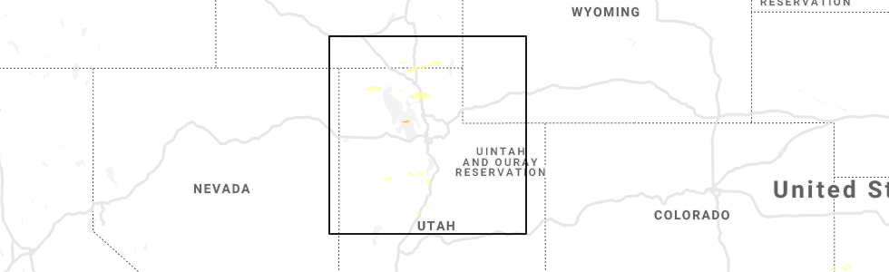
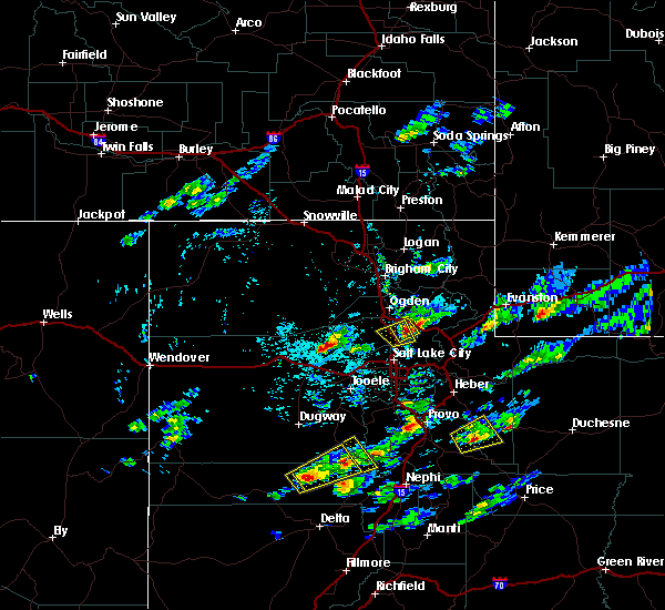
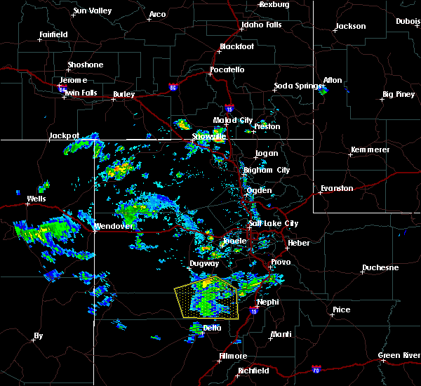
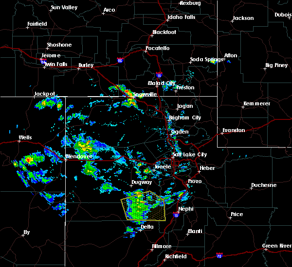
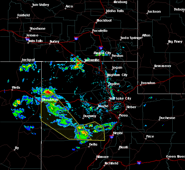
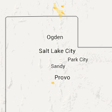
Hail Map for Eureka, UT
The Eureka, UT area has had 0 reports of on-the-ground hail by trained spotters, and has been under severe weather warnings 3 times during the past 12 months. Doppler radar has detected hail at or near Eureka, UT on 4 occasions.
| Name: | Eureka, UT |
| Where Located: | 56.5 miles SSW of Salt Lake City, UT |
| Map: | Google Map for Eureka, UT |
| Population: | 669 |
| Housing Units: | 316 |
| More Info: | Search Google for Eureka, UT |
0
The Top Recent Hail Date for Eureka, UT is Friday, April 26, 2019 (2nd out of 4)
Hail and Wind Damage Spotted near Eureka, UT
| Date / Time | Report Details |
|---|---|
| 8/2/2023 2:38 PM MDT |
 At 237 pm mdt, severe thunderstorms were located along a line extending from 7 miles east of vernon to near elk ridge, moving north at 30 mph (radar indicated). Hazards include 70 mph wind gusts and quarter size hail. Hail damage to vehicles is expected. expect considerable tree damage. wind damage is also likely to mobile homes, roofs, and outbuildings. locations impacted include, payson, spanish fork, springville, santaquin, mapleton, salem, elk ridge, woodland hills, rocky ridge, vernon, palmyra, benjamin, lake shore, spring lake, west mountain, elberta, utah lake, mona, genola and goshen. this includes the following highways, interstate 15 between mile markers 228 and 261. us route 6 between mile markers 125 and 184. thunderstorm damage threat, considerable hail threat, radar indicated max hail size, 1. 00 in wind threat, observed max wind gust, 70 mph. At 237 pm mdt, severe thunderstorms were located along a line extending from 7 miles east of vernon to near elk ridge, moving north at 30 mph (radar indicated). Hazards include 70 mph wind gusts and quarter size hail. Hail damage to vehicles is expected. expect considerable tree damage. wind damage is also likely to mobile homes, roofs, and outbuildings. locations impacted include, payson, spanish fork, springville, santaquin, mapleton, salem, elk ridge, woodland hills, rocky ridge, vernon, palmyra, benjamin, lake shore, spring lake, west mountain, elberta, utah lake, mona, genola and goshen. this includes the following highways, interstate 15 between mile markers 228 and 261. us route 6 between mile markers 125 and 184. thunderstorm damage threat, considerable hail threat, radar indicated max hail size, 1. 00 in wind threat, observed max wind gust, 70 mph.
|
| 8/2/2023 2:22 PM MDT |
 At 221 pm mdt, severe thunderstorms were located along a line extending from 11 miles southeast of vernon to 6 miles southeast of rocky ridge, moving north at 30 mph (radar indicated). Hazards include 70 mph wind gusts and quarter size hail. at 210 pm a wind gust to 77 mph was reported west of nephi. Hail damage to vehicles is expected. expect considerable tree damage. wind damage is also likely to mobile homes, roofs, and outbuildings. locations impacted include, payson, spanish fork, springville, santaquin, mapleton, salem, elk ridge, woodland hills, rocky ridge, vernon, palmyra, benjamin, lake shore, spring lake, west mountain, elberta, utah lake, mona, genola and goshen. this includes the following highways, interstate 15 between mile markers 228 and 261. us route 6 between mile markers 125 and 184. thunderstorm damage threat, considerable hail threat, radar indicated max hail size, 1. 00 in wind threat, observed max wind gust, 70 mph. At 221 pm mdt, severe thunderstorms were located along a line extending from 11 miles southeast of vernon to 6 miles southeast of rocky ridge, moving north at 30 mph (radar indicated). Hazards include 70 mph wind gusts and quarter size hail. at 210 pm a wind gust to 77 mph was reported west of nephi. Hail damage to vehicles is expected. expect considerable tree damage. wind damage is also likely to mobile homes, roofs, and outbuildings. locations impacted include, payson, spanish fork, springville, santaquin, mapleton, salem, elk ridge, woodland hills, rocky ridge, vernon, palmyra, benjamin, lake shore, spring lake, west mountain, elberta, utah lake, mona, genola and goshen. this includes the following highways, interstate 15 between mile markers 228 and 261. us route 6 between mile markers 125 and 184. thunderstorm damage threat, considerable hail threat, radar indicated max hail size, 1. 00 in wind threat, observed max wind gust, 70 mph.
|
| 8/2/2023 1:46 PM MDT |
 At 145 pm mdt, severe thunderstorms were located along a line extending from 24 miles north of delta to 8 miles south of nephi, moving north at 30 mph (radar indicated. at 120 pm a wind gust to 61 mph was reported at the sevier river bridge along i-15). Hazards include 60 mph wind gusts and quarter size hail. Hail damage to vehicles is expected. Expect wind damage to roofs, siding, and trees. At 145 pm mdt, severe thunderstorms were located along a line extending from 24 miles north of delta to 8 miles south of nephi, moving north at 30 mph (radar indicated. at 120 pm a wind gust to 61 mph was reported at the sevier river bridge along i-15). Hazards include 60 mph wind gusts and quarter size hail. Hail damage to vehicles is expected. Expect wind damage to roofs, siding, and trees.
|
| 7/3/2023 4:50 PM MDT | Mesonet station pc195 eureka ridge station elevation: 7872 f in juab county UT, 1.3 miles N of Eureka, UT |
| 7/3/2023 4:40 PM MDT | Mesonet station pc348 tintic station elevation: 6575 f in utah county UT, 0.6 miles W of Eureka, UT |
| 8/18/2021 1:46 PM MDT |
 At 145 pm mdt, severe thunderstorms were located along a line extending from 10 miles south of eagle mountain to near nephi, moving northeast at 35 mph (radar indicated). Hazards include 60 mph wind gusts. Expect damage to roofs, siding, and trees. locations impacted include, provo, payson, nephi, orem, lehi, spanish fork, pleasant grove, springville, american fork, eagle mountain, lindon, alpine, santaquin, mapleton, salem, elk ridge, woodland hills, rocky ridge, vineyard and brigham young university. this includes the following highways, interstate 15 between mile markers 223 and 282. us route 6 between mile markers 127 and 195. Us route 89 between mile markers 297 and 312. At 145 pm mdt, severe thunderstorms were located along a line extending from 10 miles south of eagle mountain to near nephi, moving northeast at 35 mph (radar indicated). Hazards include 60 mph wind gusts. Expect damage to roofs, siding, and trees. locations impacted include, provo, payson, nephi, orem, lehi, spanish fork, pleasant grove, springville, american fork, eagle mountain, lindon, alpine, santaquin, mapleton, salem, elk ridge, woodland hills, rocky ridge, vineyard and brigham young university. this includes the following highways, interstate 15 between mile markers 223 and 282. us route 6 between mile markers 127 and 195. Us route 89 between mile markers 297 and 312.
|
| 8/18/2021 1:24 PM MDT |
 At 124 pm mdt, severe thunderstorms were located along a line extending from 11 miles east of vernon to 10 miles west of nephi, moving northeast at 35 mph (radar indicated). Hazards include 60 mph wind gusts and quarter size hail. Hail damage to vehicles is expected. Expect wind damage to roofs, siding, and trees. At 124 pm mdt, severe thunderstorms were located along a line extending from 11 miles east of vernon to 10 miles west of nephi, moving northeast at 35 mph (radar indicated). Hazards include 60 mph wind gusts and quarter size hail. Hail damage to vehicles is expected. Expect wind damage to roofs, siding, and trees.
|
| 8/18/2021 1:02 PM MDT |
 At 102 pm mdt, a severe thunderstorm was located 13 miles south of vernon, or 27 miles southeast of dugway english village, moving northeast at 35 mph (radar indicated). Hazards include 60 mph wind gusts and quarter size hail. Hail damage to vehicles is expected. expect wind damage to roofs, siding, and trees. locations impacted include, vernon, eureka, little sahara state park, lofgreen, tintic junction and jericho. This includes us route 6 between mile markers 119 and 140. At 102 pm mdt, a severe thunderstorm was located 13 miles south of vernon, or 27 miles southeast of dugway english village, moving northeast at 35 mph (radar indicated). Hazards include 60 mph wind gusts and quarter size hail. Hail damage to vehicles is expected. expect wind damage to roofs, siding, and trees. locations impacted include, vernon, eureka, little sahara state park, lofgreen, tintic junction and jericho. This includes us route 6 between mile markers 119 and 140.
|
| 8/18/2021 12:34 PM MDT |
 At 1234 pm mdt, a severe thunderstorm was located 27 miles southwest of vernon, or 30 miles north of delta, moving northeast at 35 mph (radar indicated). Hazards include 60 mph wind gusts and quarter size hail. Hail damage to vehicles is expected. Expect wind damage to roofs, siding, and trees. At 1234 pm mdt, a severe thunderstorm was located 27 miles southwest of vernon, or 30 miles north of delta, moving northeast at 35 mph (radar indicated). Hazards include 60 mph wind gusts and quarter size hail. Hail damage to vehicles is expected. Expect wind damage to roofs, siding, and trees.
|
| 6/5/2020 5:50 PM MDT |
 At 550 pm mdt, severe thunderstorms were located along a line extending from 19 miles southwest of dugway english village to near mapleton, moving north at 45 mph (provo airport measured with gust of 61 mph). Hazards include 60 mph wind gusts. expect damage to roofs, siding, and trees At 550 pm mdt, severe thunderstorms were located along a line extending from 19 miles southwest of dugway english village to near mapleton, moving north at 45 mph (provo airport measured with gust of 61 mph). Hazards include 60 mph wind gusts. expect damage to roofs, siding, and trees
|
| 6/6/2019 3:11 PM MDT |
 At 311 pm mdt, a severe thunderstorm was located near elberta, or 18 miles west of payson, moving northeast at 35 mph (radar indicated). Hazards include 60 mph wind gusts and quarter size hail. Hail damage to vehicles is expected. Expect wind damage to roofs, siding, and trees. At 311 pm mdt, a severe thunderstorm was located near elberta, or 18 miles west of payson, moving northeast at 35 mph (radar indicated). Hazards include 60 mph wind gusts and quarter size hail. Hail damage to vehicles is expected. Expect wind damage to roofs, siding, and trees.
|
| 8/22/2018 3:23 PM MDT |
 The severe thunderstorm warning for northeastern juab, western utah and southeastern tooele counties will expire at 330 pm mdt, the storm which prompted the warning has weakened below severe limits, and no longer poses an immediate threat to life or property. therefore, the warning will be allowed to expire. a severe thunderstorm watch remains in effect until 900 pm mdt for central and northern utah. The severe thunderstorm warning for northeastern juab, western utah and southeastern tooele counties will expire at 330 pm mdt, the storm which prompted the warning has weakened below severe limits, and no longer poses an immediate threat to life or property. therefore, the warning will be allowed to expire. a severe thunderstorm watch remains in effect until 900 pm mdt for central and northern utah.
|
| 8/22/2018 3:16 PM MDT |
 At 316 pm mdt, a severe thunderstorm was located over elberta, or 14 miles southwest of payson, moving northeast at 20 mph (radar indicated). Hazards include 60 mph wind gusts and quarter size hail. Hail damage to vehicles is expected. expect wind damage to roofs, siding, and trees. Locations impacted include, provo, payson, orem, lehi, spanish fork, pleasant grove, springville, american fork, eagle mountain, lindon, santaquin, mapleton, salem, vernon, vineyard, palmyra, lake shore, benjamin, west mountain and elberta. At 316 pm mdt, a severe thunderstorm was located over elberta, or 14 miles southwest of payson, moving northeast at 20 mph (radar indicated). Hazards include 60 mph wind gusts and quarter size hail. Hail damage to vehicles is expected. expect wind damage to roofs, siding, and trees. Locations impacted include, provo, payson, orem, lehi, spanish fork, pleasant grove, springville, american fork, eagle mountain, lindon, santaquin, mapleton, salem, vernon, vineyard, palmyra, lake shore, benjamin, west mountain and elberta.
|
| 8/22/2018 2:48 PM MDT |
 At 248 pm mdt, a severe thunderstorm was located near elberta, or 10 miles west of payson, moving northeast at 30 mph (radar indicated). Hazards include 60 mph wind gusts and quarter size hail. Hail damage to vehicles is expected. Expect wind damage to roofs, siding, and trees. At 248 pm mdt, a severe thunderstorm was located near elberta, or 10 miles west of payson, moving northeast at 30 mph (radar indicated). Hazards include 60 mph wind gusts and quarter size hail. Hail damage to vehicles is expected. Expect wind damage to roofs, siding, and trees.
|
| 8/22/2018 2:31 PM MDT |
 At 231 pm mdt, a severe thunderstorm was located 16 miles south of vernon, or 30 miles southeast of dugway, moving northeast at 15 mph (radar indicated). Hazards include 60 mph wind gusts and quarter size hail. Hail damage to vehicles is expected. expect wind damage to roofs, siding, and trees. Locations impacted include, eureka, lofgreen and tintic junction. At 231 pm mdt, a severe thunderstorm was located 16 miles south of vernon, or 30 miles southeast of dugway, moving northeast at 15 mph (radar indicated). Hazards include 60 mph wind gusts and quarter size hail. Hail damage to vehicles is expected. expect wind damage to roofs, siding, and trees. Locations impacted include, eureka, lofgreen and tintic junction.
|
| 8/22/2018 1:58 PM MDT |
 At 157 pm mdt, a severe thunderstorm was located 23 miles southwest of vernon, or 30 miles north of delta, moving northeast at 15 mph (radar indicated). Hazards include 60 mph wind gusts and quarter size hail. Hail damage to vehicles is expected. Expect wind damage to roofs, siding, and trees. At 157 pm mdt, a severe thunderstorm was located 23 miles southwest of vernon, or 30 miles north of delta, moving northeast at 15 mph (radar indicated). Hazards include 60 mph wind gusts and quarter size hail. Hail damage to vehicles is expected. Expect wind damage to roofs, siding, and trees.
|
| 6/20/2017 5:08 PM MDT |
 At 508 pm mdt, a severe thunderstorm was located 20 miles south of vernon, or 31 miles north of delta, moving east at 25 mph (radar indicated). Hazards include 60 mph wind gusts. Expect damage to roofs, siding, and trees. Locations impacted include, vernon, eureka, lofgreen, little sahara state park, tintic junction and jericho. At 508 pm mdt, a severe thunderstorm was located 20 miles south of vernon, or 31 miles north of delta, moving east at 25 mph (radar indicated). Hazards include 60 mph wind gusts. Expect damage to roofs, siding, and trees. Locations impacted include, vernon, eureka, lofgreen, little sahara state park, tintic junction and jericho.
|
| 6/20/2017 4:47 PM MDT |
 At 447 pm mdt, a severe thunderstorm was located 21 miles south of vernon, or 30 miles north of delta, moving east at 25 mph (radar indicated). Hazards include 70 mph wind gusts. Expect considerable tree damage. damage is likely to mobile homes, roofs, and outbuildings. Locations impacted include, vernon, eureka, lofgreen, little sahara state park, tintic junction and jericho. At 447 pm mdt, a severe thunderstorm was located 21 miles south of vernon, or 30 miles north of delta, moving east at 25 mph (radar indicated). Hazards include 70 mph wind gusts. Expect considerable tree damage. damage is likely to mobile homes, roofs, and outbuildings. Locations impacted include, vernon, eureka, lofgreen, little sahara state park, tintic junction and jericho.
|
| 6/20/2017 4:27 PM MDT |
 At 426 pm mdt, a severe thunderstorm was located 26 miles southwest of vernon, or 30 miles north of delta, moving east at 25 mph (radar indicated). Hazards include 70 mph wind gusts. Expect considerable tree damage. Damage is likely to mobile homes, roofs, and outbuildings. At 426 pm mdt, a severe thunderstorm was located 26 miles southwest of vernon, or 30 miles north of delta, moving east at 25 mph (radar indicated). Hazards include 70 mph wind gusts. Expect considerable tree damage. Damage is likely to mobile homes, roofs, and outbuildings.
|
| 12/16/2016 12:58 PM MST |
 The severe thunderstorm warning for utah, southeastern tooele, eastern salt lake, northeastern juab, south central morgan, northwestern wasatch and southwestern summit counties will expire at 100 pm mst, the storms which prompted the warning have weakened below severe limits, and no longer pose an immediate threat to life or property. therefore the warning will be allowed to expire. however gusty winds are still possible with any lingering thunderstorms. The severe thunderstorm warning for utah, southeastern tooele, eastern salt lake, northeastern juab, south central morgan, northwestern wasatch and southwestern summit counties will expire at 100 pm mst, the storms which prompted the warning have weakened below severe limits, and no longer pose an immediate threat to life or property. therefore the warning will be allowed to expire. however gusty winds are still possible with any lingering thunderstorms.
|
| 12/16/2016 12:20 PM MST |
 At 1218 pm mst, doppler radar indicated a line of severe thunderstorms capable of producing damaging winds in excess of 60 mph. these storms were located along a line extending from near summit park to 25 miles northwest of delta, and moving southeast at 35 mph. At 1218 pm mst, doppler radar indicated a line of severe thunderstorms capable of producing damaging winds in excess of 60 mph. these storms were located along a line extending from near summit park to 25 miles northwest of delta, and moving southeast at 35 mph.
|
| 12/16/2016 12:00 PM MST |
 At 1154 am mst, doppler radar indicated a line of severe thunderstorms capable of producing damaging winds in excess of 60 mph. these storms were located along a line extending from 8 mile northeast of morgan to 8 miles southwest of vernon, moving southeast at 45 mph. the strongest storms along this line will exist across salt lake, northwest utah and southeast tooele counties through 1215 pm mst. locations impacted include, salt lake city, west valley city, sandy, murray, bountiful, tooele, farmington, park city, morgan, coalville, west jordan, taylorsville, south jordan, lehi, draper, riverton, pleasant grove, cottonwood heights, midvale and kaysville. At 1154 am mst, doppler radar indicated a line of severe thunderstorms capable of producing damaging winds in excess of 60 mph. these storms were located along a line extending from 8 mile northeast of morgan to 8 miles southwest of vernon, moving southeast at 45 mph. the strongest storms along this line will exist across salt lake, northwest utah and southeast tooele counties through 1215 pm mst. locations impacted include, salt lake city, west valley city, sandy, murray, bountiful, tooele, farmington, park city, morgan, coalville, west jordan, taylorsville, south jordan, lehi, draper, riverton, pleasant grove, cottonwood heights, midvale and kaysville.
|
| 12/16/2016 11:40 AM MST |
 At 1138 am mst, doppler radar indicated a line of severe thunderstorms capable of producing damaging winds in excess of 60 mph. these storms were located along a line extending from 14 miles north of morgan to 12 miles south of dugway, and moving southeast at 45 mph. At 1138 am mst, doppler radar indicated a line of severe thunderstorms capable of producing damaging winds in excess of 60 mph. these storms were located along a line extending from 14 miles north of morgan to 12 miles south of dugway, and moving southeast at 45 mph.
|
| 11/23/2016 5:39 PM MST |
 The severe thunderstorm warning for utah, southeastern tooele and northeastern juab counties will expire at 545 pm mst, the storms which prompted the warning have weakened below severe limits and exited the warned area. therefore the warning will be allowed to expire. The severe thunderstorm warning for utah, southeastern tooele and northeastern juab counties will expire at 545 pm mst, the storms which prompted the warning have weakened below severe limits and exited the warned area. therefore the warning will be allowed to expire.
|
| 11/23/2016 5:10 PM MST |
 At 510 pm mst, doppler radar indicated severe thunderstorms with a history of producing damaging winds in excess of 60 mph. these storms were located along a line extending from near lehi to 6 miles southwest of elberta, moving east at 40 mph. locations impacted include, provo, payson, nephi, orem, lehi, draper, spanish fork, pleasant grove, springville, american fork, eagle mountain, lindon, alpine, santaquin, mapleton, bluffdale, salem, elk ridge, woodland hills and rocky ridge. At 510 pm mst, doppler radar indicated severe thunderstorms with a history of producing damaging winds in excess of 60 mph. these storms were located along a line extending from near lehi to 6 miles southwest of elberta, moving east at 40 mph. locations impacted include, provo, payson, nephi, orem, lehi, draper, spanish fork, pleasant grove, springville, american fork, eagle mountain, lindon, alpine, santaquin, mapleton, bluffdale, salem, elk ridge, woodland hills and rocky ridge.
|
| 11/23/2016 4:40 PM MST |
 At 440 pm mst, doppler radar indicated a line of severe thunderstorms capable of producing damaging winds in excess of 60 mph. these storms were located along a line extending from 13 miles south of cedar fort to 25 miles northeast of delta, and moving east at 50 mph. At 440 pm mst, doppler radar indicated a line of severe thunderstorms capable of producing damaging winds in excess of 60 mph. these storms were located along a line extending from 13 miles south of cedar fort to 25 miles northeast of delta, and moving east at 50 mph.
|
| 1/1/0001 12:00 AM | Us-6 at eureka senso in utah county UT, 0.6 miles W of Eureka, UT |
Hail Maps for Eureka, UT


Connect with Interactive Hail Maps