

Hail Map for Fort Jones, CA
The Fort Jones, CA area has had 0 reports of on-the-ground hail by trained spotters, and has been under severe weather warnings 0 times during the past 12 months. Doppler radar has detected hail at or near Fort Jones, CA on 6 occasions, including 1 occasion during the past year.
| Name: | Fort Jones, CA |
| Where Located: | 49.3 miles S of Medford, OR |
| Map: | Google Map for Fort Jones, CA |
| Population: | 839 |
| Housing Units: | 344 |
| More Info: | Search Google for Fort Jones, CA |
0
The Top Recent Hail Date for Fort Jones, CA is Friday, August 4, 2023 (6th out of 6)

Hail and Wind Damage Spotted near Fort Jones, CA
| Date / Time | Report Details |
|---|---|
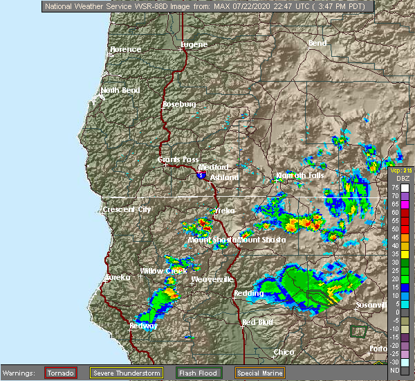
| 7/22/2020 4:35 PM PDT |
 The severe thunderstorm warning for western siskiyou county will expire at 445 pm pdt, the storm which prompted the warning has weakened below severe limits, and has exited the warned area. therefore, the warning will be allowed to expire. however gusty winds and heavy rain are still possible with this thunderstorm. The severe thunderstorm warning for western siskiyou county will expire at 445 pm pdt, the storm which prompted the warning has weakened below severe limits, and has exited the warned area. therefore, the warning will be allowed to expire. however gusty winds and heavy rain are still possible with this thunderstorm.
|
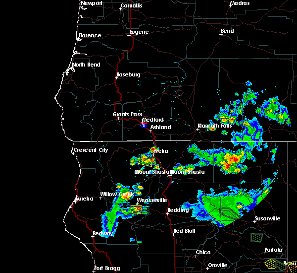
| 7/22/2020 4:27 PM PDT |
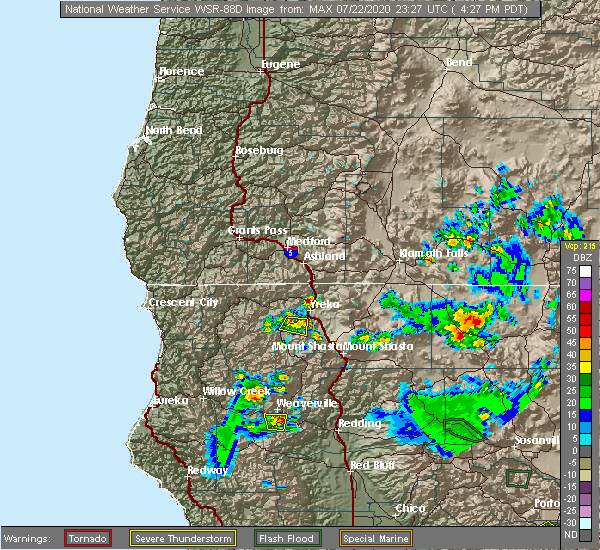 At 426 pm pdt, a severe thunderstorm was located over fort jones, or 11 miles southwest of yreka, and is nearly stationary (radar indicated). Hazards include 60 mph wind gusts and quarter size hail. Hail damage to vehicles is expected. expect wind damage to roofs, siding, and trees. locations impacted include, fort jones and greenview. This includes highway 3 in california between mile markers 28 and 40. At 426 pm pdt, a severe thunderstorm was located over fort jones, or 11 miles southwest of yreka, and is nearly stationary (radar indicated). Hazards include 60 mph wind gusts and quarter size hail. Hail damage to vehicles is expected. expect wind damage to roofs, siding, and trees. locations impacted include, fort jones and greenview. This includes highway 3 in california between mile markers 28 and 40.
|
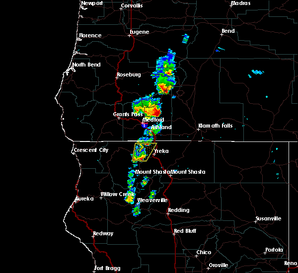
| 7/22/2020 4:12 PM PDT |
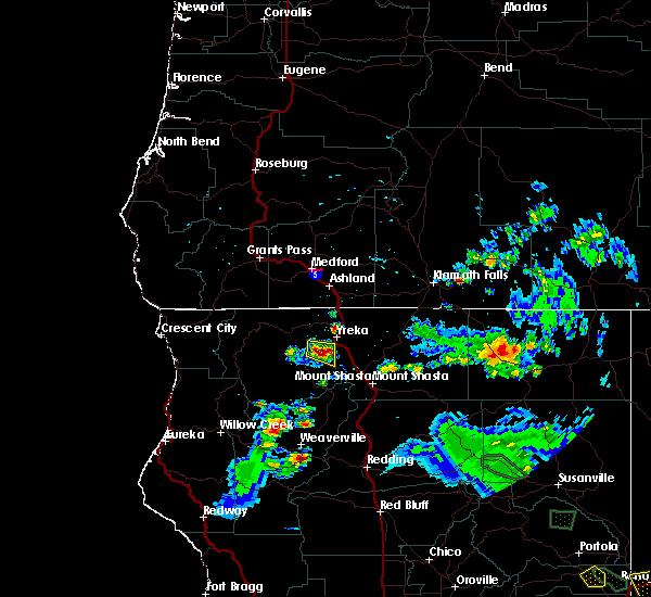 At 412 pm pdt, a severe thunderstorm was located over fort jones, or 11 miles southwest of yreka, and is nearly stationary (radar indicated). Hazards include 60 mph wind gusts and half dollar size hail. Hail damage to vehicles is expected. Expect wind damage to roofs, siding, and trees. At 412 pm pdt, a severe thunderstorm was located over fort jones, or 11 miles southwest of yreka, and is nearly stationary (radar indicated). Hazards include 60 mph wind gusts and half dollar size hail. Hail damage to vehicles is expected. Expect wind damage to roofs, siding, and trees.
|
| 7/22/2020 4:00 PM PDT |
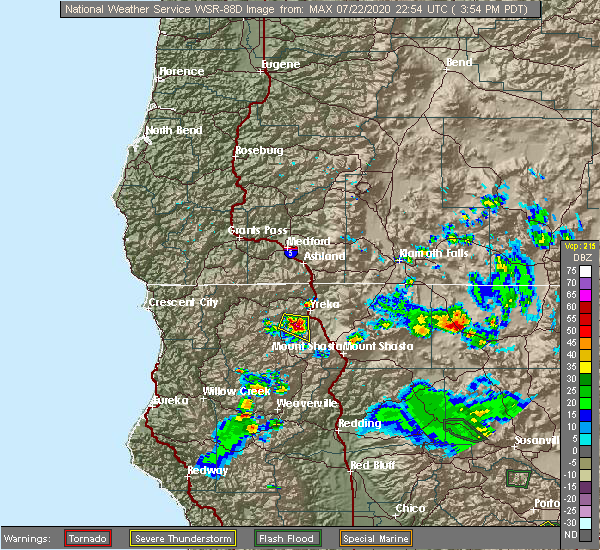 At 359 pm pdt, a severe thunderstorm was located near fort jones, or 10 miles southwest of yreka, and is nearly stationary (radar indicated). Hazards include 60 mph wind gusts and quarter size hail. Hail damage to vehicles is expected. expect wind damage to roofs, siding, and trees. locations impacted include, fort jones. This includes highway 3 in california between mile markers 30 and 45. At 359 pm pdt, a severe thunderstorm was located near fort jones, or 10 miles southwest of yreka, and is nearly stationary (radar indicated). Hazards include 60 mph wind gusts and quarter size hail. Hail damage to vehicles is expected. expect wind damage to roofs, siding, and trees. locations impacted include, fort jones. This includes highway 3 in california between mile markers 30 and 45.
|
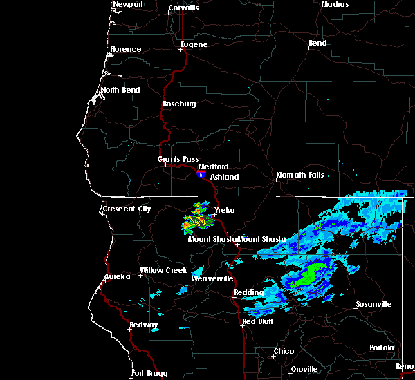
| 7/22/2020 3:49 PM PDT |
 At 349 pm pdt, a severe thunderstorm was located near fort jones, or 10 miles southwest of yreka, and is nearly stationary (radar indicated). Hazards include 60 mph wind gusts and quarter size hail. Hail damage to vehicles is expected. Expect wind damage to roofs, siding, and trees. At 349 pm pdt, a severe thunderstorm was located near fort jones, or 10 miles southwest of yreka, and is nearly stationary (radar indicated). Hazards include 60 mph wind gusts and quarter size hail. Hail damage to vehicles is expected. Expect wind damage to roofs, siding, and trees.
|
| 5/4/2017 7:13 PM PDT |
 At 713 pm pdt, a severe thunderstorm was located near fort jones, or 11 miles west of yreka, moving north at 45 mph (radar indicated). Hazards include 60 mph wind gusts and quarter size hail, heavy rain. Hail damage to vehicles is expected. Expect wind damage to roofs, siding, and trees. At 713 pm pdt, a severe thunderstorm was located near fort jones, or 11 miles west of yreka, moving north at 45 mph (radar indicated). Hazards include 60 mph wind gusts and quarter size hail, heavy rain. Hail damage to vehicles is expected. Expect wind damage to roofs, siding, and trees.
|
| 8/4/2015 8:23 PM PDT |
 The severe thunderstorm warning for northwestern siskiyou county will expire at 830 pm pdt, the storm which prompted the warning has weakened below severe limits, and no longer poses an immediate threat to life or property. therefore the warning will be allowed to expire. even though the storm is no longer severe, it is still producing very heavy rain. a flash flood warning has been issued for highway 3 east of fort jones until 1015 pm pdt. The severe thunderstorm warning for northwestern siskiyou county will expire at 830 pm pdt, the storm which prompted the warning has weakened below severe limits, and no longer poses an immediate threat to life or property. therefore the warning will be allowed to expire. even though the storm is no longer severe, it is still producing very heavy rain. a flash flood warning has been issued for highway 3 east of fort jones until 1015 pm pdt.
|
| 8/4/2015 7:57 PM PDT |
 At 757 pm pdt, doppler radar indicated a severe thunderstorm capable of producing quarter size hail. this storm was located near fort jones, or 9 miles southwest of yreka, and moving north at 5 mph. this storm will impact highway 3 between yreka and fort jones. At 757 pm pdt, doppler radar indicated a severe thunderstorm capable of producing quarter size hail. this storm was located near fort jones, or 9 miles southwest of yreka, and moving north at 5 mph. this storm will impact highway 3 between yreka and fort jones.
|
Hail Maps for Fort Jones, CA


Connect with Interactive Hail Maps