

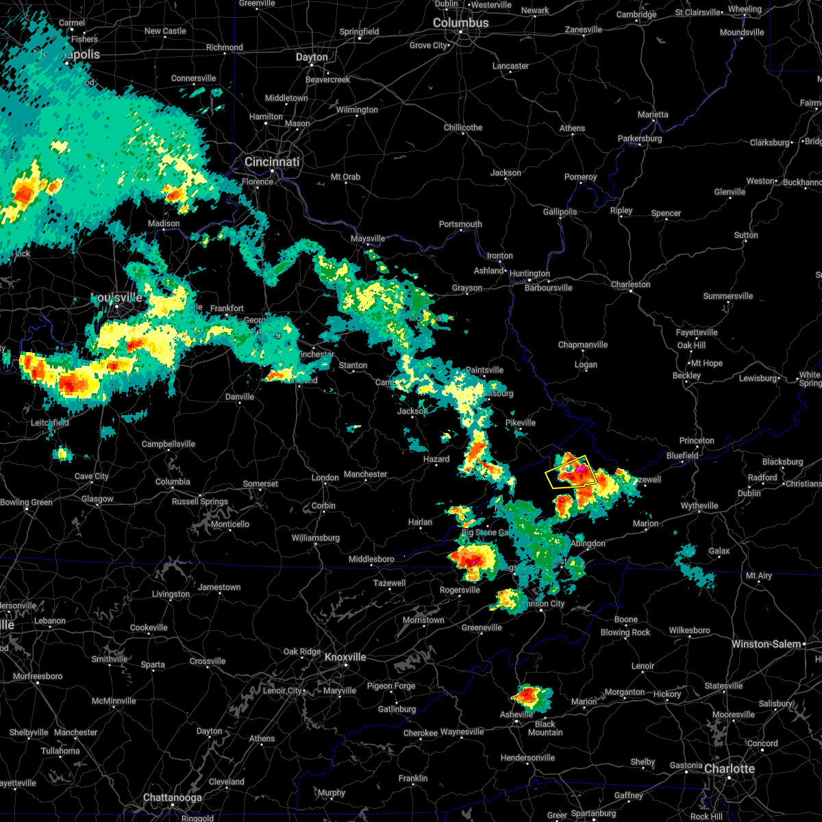
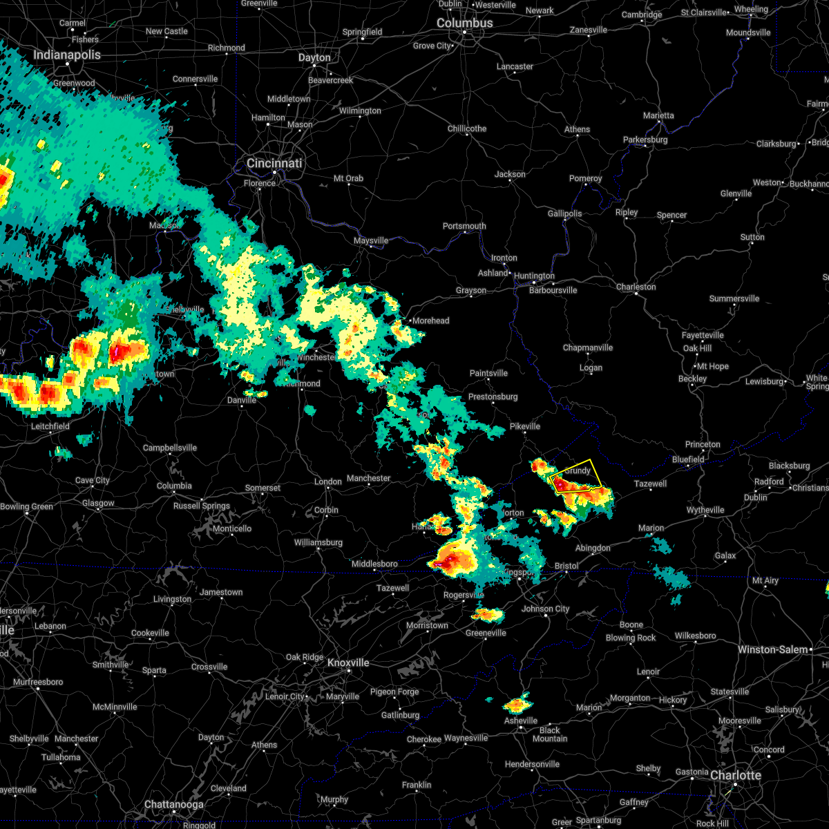
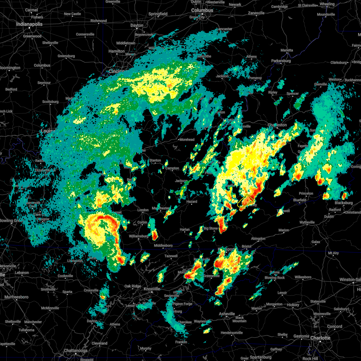
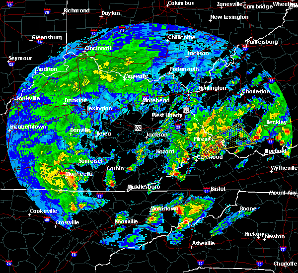
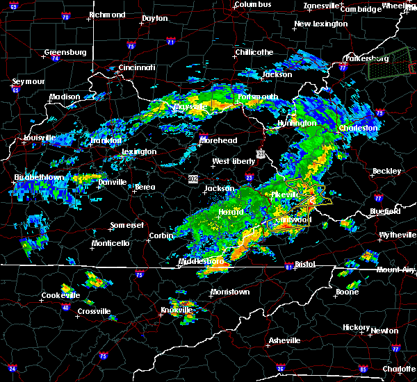
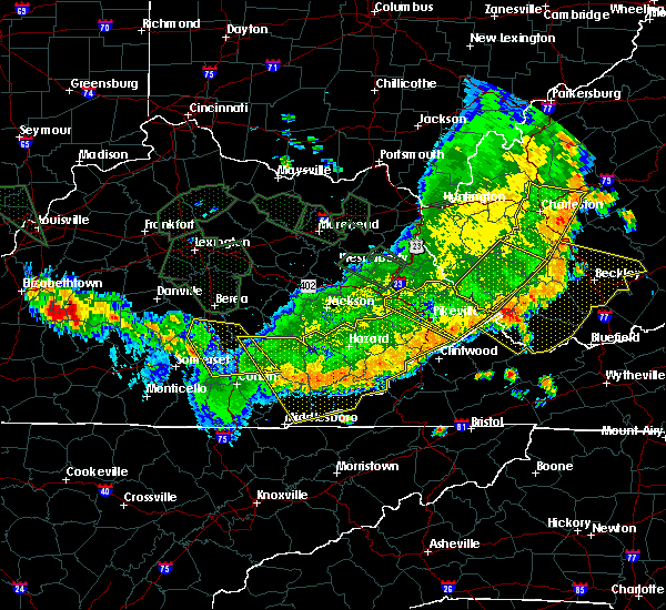
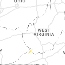
Hail Map for Haysi, VA
The Haysi, VA area has had 3 reports of on-the-ground hail by trained spotters, and has been under severe weather warnings 8 times during the past 12 months. Doppler radar has detected hail at or near Haysi, VA on 22 occasions, including 1 occasion during the past year.
| Name: | Haysi, VA |
| Where Located: | 42.7 miles N of Bristol, TN |
| Map: | Google Map for Haysi, VA |
| Population: | 498 |
| Housing Units: | 128 |
| More Info: | Search Google for Haysi, VA |
1
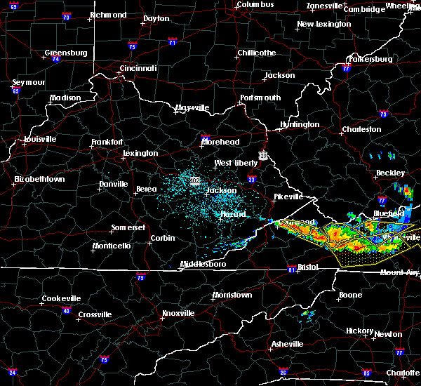
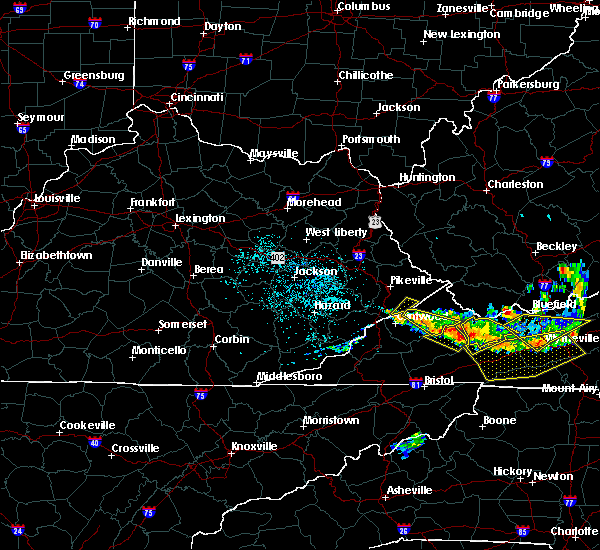
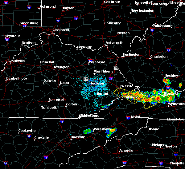
The Top Recent Hail Date for Haysi, VA is Friday, July 14, 2023 (11th out of 22)

Hail and Wind Damage Spotted near Haysi, VA
| Date / Time | Report Details |
|---|---|
| 9/9/2023 4:53 PM EDT |
 At 453 pm edt, a severe thunderstorm was located near haysi, moving north at 10 mph (radar indicated). Hazards include 60 mph wind gusts and penny size hail. Expect damage to roofs, siding, and trees. locations impacted include, clintwood, haysi, john flannagan lake, clinchco, and mcclure. hail threat, radar indicated max hail size, 0. 75 in wind threat, radar indicated max wind gust, 60 mph. At 453 pm edt, a severe thunderstorm was located near haysi, moving north at 10 mph (radar indicated). Hazards include 60 mph wind gusts and penny size hail. Expect damage to roofs, siding, and trees. locations impacted include, clintwood, haysi, john flannagan lake, clinchco, and mcclure. hail threat, radar indicated max hail size, 0. 75 in wind threat, radar indicated max wind gust, 60 mph.
|
| 9/9/2023 4:30 PM EDT |
 At 429 pm edt, a severe thunderstorm was located near clintwood, moving northeast at 15 mph (radar indicated). Hazards include 60 mph wind gusts and penny size hail. expect damage to roofs, siding, and trees At 429 pm edt, a severe thunderstorm was located near clintwood, moving northeast at 15 mph (radar indicated). Hazards include 60 mph wind gusts and penny size hail. expect damage to roofs, siding, and trees
|
| 7/29/2023 4:47 PM EDT |
 At 446 pm edt, severe thunderstorms were located along a line extending from near john flannagan lake to near trammel to 9 miles south of clintwood to near wise to near norton, moving southeast at 30 mph (radar indicated). Hazards include 60 mph wind gusts and penny size hail. Expect damage to roofs, siding, and trees. locations impacted include, grundy, haysi, davenport, breaks interstate, john flannagan lake, trammel, big rock, clinchco, nora, vansant, mcclure, and oakwood. hail threat, radar indicated max hail size, 0. 75 in wind threat, radar indicated max wind gust, 60 mph. At 446 pm edt, severe thunderstorms were located along a line extending from near john flannagan lake to near trammel to 9 miles south of clintwood to near wise to near norton, moving southeast at 30 mph (radar indicated). Hazards include 60 mph wind gusts and penny size hail. Expect damage to roofs, siding, and trees. locations impacted include, grundy, haysi, davenport, breaks interstate, john flannagan lake, trammel, big rock, clinchco, nora, vansant, mcclure, and oakwood. hail threat, radar indicated max hail size, 0. 75 in wind threat, radar indicated max wind gust, 60 mph.
|
| 7/29/2023 4:29 PM EDT |
 At 429 pm edt, severe thunderstorms were located along a line extending from near ashcamp to near clintwood to wise to near big stone gap, moving southeast at 35 mph (radar indicated). Hazards include 60 mph wind gusts and penny size hail. expect damage to roofs, siding, and trees At 429 pm edt, severe thunderstorms were located along a line extending from near ashcamp to near clintwood to wise to near big stone gap, moving southeast at 35 mph (radar indicated). Hazards include 60 mph wind gusts and penny size hail. expect damage to roofs, siding, and trees
|
| 7/29/2023 4:19 PM EDT |
 At 419 pm edt, severe thunderstorms were located along a line extending from near shelby gap to clintwood to 7 miles southeast of burdine to near wise, moving southeast at 40 mph (radar indicated). Hazards include 60 mph wind gusts and penny size hail. Expect damage to roofs, siding, and trees. locations impacted include, clintwood, haysi, trammel, clinchco, mcclure, and nora. hail threat, radar indicated max hail size, 0. 75 in wind threat, radar indicated max wind gust, 60 mph. At 419 pm edt, severe thunderstorms were located along a line extending from near shelby gap to clintwood to 7 miles southeast of burdine to near wise, moving southeast at 40 mph (radar indicated). Hazards include 60 mph wind gusts and penny size hail. Expect damage to roofs, siding, and trees. locations impacted include, clintwood, haysi, trammel, clinchco, mcclure, and nora. hail threat, radar indicated max hail size, 0. 75 in wind threat, radar indicated max wind gust, 60 mph.
|
| 7/29/2023 4:05 PM EDT |
 At 404 pm edt, severe thunderstorms were located along a line extending from burdine to near gaskill to near payne gap to near eolia, moving southeast at 45 mph (radar indicated). Hazards include 60 mph wind gusts and penny size hail. expect damage to roofs, siding, and trees At 404 pm edt, severe thunderstorms were located along a line extending from burdine to near gaskill to near payne gap to near eolia, moving southeast at 45 mph (radar indicated). Hazards include 60 mph wind gusts and penny size hail. expect damage to roofs, siding, and trees
|
| 6/3/2023 5:23 PM EDT | Tree down blocking one lane of breaks park rd. reported at 547 pm. event time estimated from rada in dickenson county VA, 0.4 miles WSW of Haysi, VA |
| 5/16/2023 5:49 PM EDT | Tree down on a vehicle in a driveway along pat field road in hays in dickenson county VA, 1.9 miles SE of Haysi, VA |
| 5/16/2023 5:40 PM EDT | *** 1 fatal *** tree fell onto an occupied vehicle on welcome lan in dickenson county VA, 2.2 miles WSW of Haysi, VA |
| 5/16/2023 5:39 PM EDT |
 At 538 pm edt, a severe thunderstorm was located 7 miles southeast of grundy, moving east at 55 mph. this is a destructive storm for oakwood (radar indicated). Hazards include 80 mph wind gusts. Flying debris will be dangerous to those caught without shelter. mobile homes will be heavily damaged. expect considerable damage to roofs, windows, and vehicles. extensive tree damage and power outages are likely. locations impacted include, clintwood, grundy, haysi, davenport, john flannagan lake, trammel, clinchco, nora, vansant, mcclure and oakwood. thunderstorm damage threat, destructive hail threat, radar indicated max hail size, <. 75 in wind threat, radar indicated max wind gust, 80 mph. At 538 pm edt, a severe thunderstorm was located 7 miles southeast of grundy, moving east at 55 mph. this is a destructive storm for oakwood (radar indicated). Hazards include 80 mph wind gusts. Flying debris will be dangerous to those caught without shelter. mobile homes will be heavily damaged. expect considerable damage to roofs, windows, and vehicles. extensive tree damage and power outages are likely. locations impacted include, clintwood, grundy, haysi, davenport, john flannagan lake, trammel, clinchco, nora, vansant, mcclure and oakwood. thunderstorm damage threat, destructive hail threat, radar indicated max hail size, <. 75 in wind threat, radar indicated max wind gust, 80 mph.
|
| 5/16/2023 5:33 PM EDT | Tree down along gc powers driv in dickenson county VA, 0.7 miles E of Haysi, VA |
| 5/16/2023 5:25 PM EDT | Trees and power lines down on doe branc in dickenson county VA, 1.5 miles W of Haysi, VA |
| 5/16/2023 5:24 PM EDT | Trees down all over vicey mountain road and 4 trees down on a hous in dickenson county VA, 2.7 miles WSW of Haysi, VA |
| 5/16/2023 5:24 PM EDT | Trees down along bartlick road and little rockhouse roa in dickenson county VA, 1.5 miles S of Haysi, VA |
| 5/16/2023 5:22 PM EDT |
 At 521 pm edt, a severe thunderstorm was located over haysi, moving east at 55 mph. this is a destructive storm for haysi (radar indicated). Hazards include 90 mph wind gusts. You are in a life-threatening situation. flying debris may be deadly to those caught without shelter. mobile homes will be heavily damaged or destroyed. homes and businesses will have substantial roof and window damage. Expect extensive tree damage and power outages. At 521 pm edt, a severe thunderstorm was located over haysi, moving east at 55 mph. this is a destructive storm for haysi (radar indicated). Hazards include 90 mph wind gusts. You are in a life-threatening situation. flying debris may be deadly to those caught without shelter. mobile homes will be heavily damaged or destroyed. homes and businesses will have substantial roof and window damage. Expect extensive tree damage and power outages.
|
| 5/16/2023 5:19 PM EDT | Tree down along centennial heights roa in dickenson county VA, 0.7 miles E of Haysi, VA |
| 8/5/2022 6:07 PM EDT |
 At 607 pm edt, a severe thunderstorm was located near clintwood, moving northeast at 15 mph (radar indicated). Hazards include 60 mph wind gusts and penny size hail. expect damage to roofs, siding, and trees At 607 pm edt, a severe thunderstorm was located near clintwood, moving northeast at 15 mph (radar indicated). Hazards include 60 mph wind gusts and penny size hail. expect damage to roofs, siding, and trees
|
| 6/17/2022 2:50 PM EDT | Multiple trees and powerlines down across the tow in dickenson county VA, 0.4 miles WSW of Haysi, VA |
| 6/17/2022 2:30 PM EDT |
 At 230 pm edt, severe thunderstorms were located along a line extending from jenkins to near bald knob, moving southeast at 45 mph (radar indicated). Hazards include 60 mph wind gusts. expect damage to roofs, siding, and trees At 230 pm edt, severe thunderstorms were located along a line extending from jenkins to near bald knob, moving southeast at 45 mph (radar indicated). Hazards include 60 mph wind gusts. expect damage to roofs, siding, and trees
|
| 6/2/2022 11:56 AM EDT |
 The severe thunderstorm warning for central dickenson and west central buchanan counties will expire at noon edt, the storm which prompted the warning has weakened below severe limits, and has exited the warned area. therefore, the warning will be allowed to expire. however heavy rain is still possible with this thunderstorm. The severe thunderstorm warning for central dickenson and west central buchanan counties will expire at noon edt, the storm which prompted the warning has weakened below severe limits, and has exited the warned area. therefore, the warning will be allowed to expire. however heavy rain is still possible with this thunderstorm.
|
| 6/2/2022 11:47 AM EDT |
 At 1146 am edt, a severe thunderstorm was located near haysi, moving east at 35 mph (radar indicated). Hazards include 60 mph wind gusts and quarter size hail. Hail damage to vehicles is expected. expect wind damage to roofs, siding, and trees. locations impacted include, haysi, john flannagan lake, clinchco and mcclure. hail threat, radar indicated max hail size, 1. 00 in wind threat, radar indicated max wind gust, 60 mph. At 1146 am edt, a severe thunderstorm was located near haysi, moving east at 35 mph (radar indicated). Hazards include 60 mph wind gusts and quarter size hail. Hail damage to vehicles is expected. expect wind damage to roofs, siding, and trees. locations impacted include, haysi, john flannagan lake, clinchco and mcclure. hail threat, radar indicated max hail size, 1. 00 in wind threat, radar indicated max wind gust, 60 mph.
|
| 6/2/2022 11:23 AM EDT |
 At 1122 am edt, a severe thunderstorm was located over clintwood, moving east at 35 mph (radar indicated). Hazards include 60 mph wind gusts and quarter size hail. Hail damage to vehicles is expected. Expect wind damage to roofs, siding, and trees. At 1122 am edt, a severe thunderstorm was located over clintwood, moving east at 35 mph (radar indicated). Hazards include 60 mph wind gusts and quarter size hail. Hail damage to vehicles is expected. Expect wind damage to roofs, siding, and trees.
|
| 5/19/2022 6:35 PM EDT |
 The severe thunderstorm warning for east central dickenson and southwestern buchanan counties will expire at 645 pm edt, the storm which prompted the warning has moved out of the area. therefore, the warning will be allowed to expire. however small hail, gusty winds and heavy rain are still possible with this thunderstorm. The severe thunderstorm warning for east central dickenson and southwestern buchanan counties will expire at 645 pm edt, the storm which prompted the warning has moved out of the area. therefore, the warning will be allowed to expire. however small hail, gusty winds and heavy rain are still possible with this thunderstorm.
|
| 5/19/2022 6:09 PM EDT |
 The severe thunderstorm warning for central dickenson county will expire at 615 pm edt, the storm which prompted the warning has moved out of the area. therefore, the warning will be allowed to expire. however small hail, gusty winds and heavy rain are still possible with this thunderstorm. The severe thunderstorm warning for central dickenson county will expire at 615 pm edt, the storm which prompted the warning has moved out of the area. therefore, the warning will be allowed to expire. however small hail, gusty winds and heavy rain are still possible with this thunderstorm.
|
| 5/19/2022 6:08 PM EDT |
 At 608 pm edt, a severe thunderstorm was located near haysi, moving east at 30 mph (radar indicated). Hazards include 70 mph wind gusts and ping pong ball size hail. People and animals outdoors will be injured. expect hail damage to roofs, siding, windows, and vehicles. expect considerable tree damage. Wind damage is also likely to mobile homes, roofs, and outbuildings. At 608 pm edt, a severe thunderstorm was located near haysi, moving east at 30 mph (radar indicated). Hazards include 70 mph wind gusts and ping pong ball size hail. People and animals outdoors will be injured. expect hail damage to roofs, siding, windows, and vehicles. expect considerable tree damage. Wind damage is also likely to mobile homes, roofs, and outbuildings.
|
| 5/19/2022 6:07 PM EDT | Several trees down throughout the haysi area. time estimated with rada in dickenson county VA, 1.1 miles WNW of Haysi, VA |
| 5/19/2022 5:50 PM EDT |
 At 549 pm edt, a severe thunderstorm was located near clintwood, moving east at 20 mph (radar indicated). Hazards include 60 mph wind gusts and quarter size hail. Hail damage to vehicles is expected. Expect wind damage to roofs, siding, and trees. At 549 pm edt, a severe thunderstorm was located near clintwood, moving east at 20 mph (radar indicated). Hazards include 60 mph wind gusts and quarter size hail. Hail damage to vehicles is expected. Expect wind damage to roofs, siding, and trees.
|
| 6/21/2021 6:10 PM EDT |
 At 609 pm edt, a severe thunderstorm was located over clintwood, moving east at 30 mph (radar indicated). Hazards include 60 mph wind gusts and penny size hail. expect damage to roofs, siding, and trees At 609 pm edt, a severe thunderstorm was located over clintwood, moving east at 30 mph (radar indicated). Hazards include 60 mph wind gusts and penny size hail. expect damage to roofs, siding, and trees
|
| 7/17/2020 5:07 PM EDT |
 The severe thunderstorm warning for central dickenson and southwestern buchanan counties will expire at 515 pm edt, the storm which prompted the warning has weakened below severe limits, and no longer poses an immediate threat to life or property. therefore, the warning will be allowed to expire. The severe thunderstorm warning for central dickenson and southwestern buchanan counties will expire at 515 pm edt, the storm which prompted the warning has weakened below severe limits, and no longer poses an immediate threat to life or property. therefore, the warning will be allowed to expire.
|
| 7/17/2020 4:48 PM EDT |
 At 447 pm edt, a severe thunderstorm was located near haysi, moving east at 20 mph (radar indicated). Hazards include 60 mph wind gusts and penny size hail. Expect damage to roofs, siding, and trees. Locations impacted include, clintwood, grundy, haysi, john flannagan lake, clinchco, vansant and mcclure. At 447 pm edt, a severe thunderstorm was located near haysi, moving east at 20 mph (radar indicated). Hazards include 60 mph wind gusts and penny size hail. Expect damage to roofs, siding, and trees. Locations impacted include, clintwood, grundy, haysi, john flannagan lake, clinchco, vansant and mcclure.
|
| 7/17/2020 4:28 PM EDT |
 At 428 pm edt, a severe thunderstorm was located near haysi, moving east at 20 mph (radar indicated). Hazards include 60 mph wind gusts and penny size hail. expect damage to roofs, siding, and trees At 428 pm edt, a severe thunderstorm was located near haysi, moving east at 20 mph (radar indicated). Hazards include 60 mph wind gusts and penny size hail. expect damage to roofs, siding, and trees
|
| 1/11/2020 7:35 PM EST |
 At 735 pm est, severe thunderstorms were located along a line extending from near rockhouse to john flannagan lake to 8 miles northwest of allison gap to near abingdon, moving northeast at 65 mph (radar indicated). Hazards include 60 mph wind gusts. Expect damage to roofs, siding, and trees. Locations impacted include, grundy, haysi, davenport, breaks interstate, john flannagan lake, big rock, clinchco, stacy, vansant, hurley, oakwood and roseann. At 735 pm est, severe thunderstorms were located along a line extending from near rockhouse to john flannagan lake to 8 miles northwest of allison gap to near abingdon, moving northeast at 65 mph (radar indicated). Hazards include 60 mph wind gusts. Expect damage to roofs, siding, and trees. Locations impacted include, grundy, haysi, davenport, breaks interstate, john flannagan lake, big rock, clinchco, stacy, vansant, hurley, oakwood and roseann.
|
| 1/11/2020 7:15 PM EST |
 At 714 pm est, severe thunderstorms were located along a line extending from deane to near payne gap to 7 miles south of cleveland va to near bristol tn, moving northeast at 65 mph (radar indicated). Hazards include 70 mph wind gusts. Expect considerable tree damage. Damage is likely to mobile homes, roofs, and outbuildings. At 714 pm est, severe thunderstorms were located along a line extending from deane to near payne gap to 7 miles south of cleveland va to near bristol tn, moving northeast at 65 mph (radar indicated). Hazards include 70 mph wind gusts. Expect considerable tree damage. Damage is likely to mobile homes, roofs, and outbuildings.
|
| 10/31/2019 1:12 PM EDT | Tree down on spillway lan in dickenson county VA, 2.8 miles ESE of Haysi, VA |
| 10/31/2019 12:57 PM EDT |
 The national weather service in charleston west virginia has issued a * severe thunderstorm warning for. northeastern dickenson county in southwestern virginia. buchanan county in southwestern virginia. southwestern mcdowell county in southern west virginia. Until 145 pm edt. The national weather service in charleston west virginia has issued a * severe thunderstorm warning for. northeastern dickenson county in southwestern virginia. buchanan county in southwestern virginia. southwestern mcdowell county in southern west virginia. Until 145 pm edt.
|
| 5/29/2019 3:17 PM EDT |
 At 316 pm edt, a severe thunderstorm was located over shelby gap, or near clintwood, moving east at 35 mph. additional severe thunderstorms are also expected to move into the warned area over the next hour (radar indicated). Hazards include 70 mph wind gusts and ping pong ball size hail. People and animals outdoors will be injured. expect hail damage to roofs, siding, windows, and vehicles. expect considerable tree damage. Wind damage is also likely to mobile homes, roofs, and outbuildings. At 316 pm edt, a severe thunderstorm was located over shelby gap, or near clintwood, moving east at 35 mph. additional severe thunderstorms are also expected to move into the warned area over the next hour (radar indicated). Hazards include 70 mph wind gusts and ping pong ball size hail. People and animals outdoors will be injured. expect hail damage to roofs, siding, windows, and vehicles. expect considerable tree damage. Wind damage is also likely to mobile homes, roofs, and outbuildings.
|
| 5/5/2018 5:12 PM EDT |
 The severe thunderstorm warning for north central dickenson and west central buchanan counties will expire at 515 pm edt, the storm which prompted the warning has moved out of the area. therefore the warning will be allowed to expire. however small hail and heavy rain are still possible with this thunderstorm. The severe thunderstorm warning for north central dickenson and west central buchanan counties will expire at 515 pm edt, the storm which prompted the warning has moved out of the area. therefore the warning will be allowed to expire. however small hail and heavy rain are still possible with this thunderstorm.
|
| 5/5/2018 4:55 PM EDT |
 At 454 pm edt, a severe thunderstorm was located over breaks interstate, moving northeast at 30 mph. spotters at john flannigan lake reported half dollar sized hail (trained weather spotters). Hazards include 60 mph wind gusts and half dollar size hail. Hail damage to vehicles is expected. expect wind damage to roofs, siding, and trees. locations impacted include, grundy, haysi, breaks interstate, john flannagan lake and big rock. At 454 pm edt, a severe thunderstorm was located over breaks interstate, moving northeast at 30 mph. spotters at john flannigan lake reported half dollar sized hail (trained weather spotters). Hazards include 60 mph wind gusts and half dollar size hail. Hail damage to vehicles is expected. expect wind damage to roofs, siding, and trees. locations impacted include, grundy, haysi, breaks interstate, john flannagan lake and big rock.
|
| 5/5/2018 4:52 PM EDT | Golf Ball sized hail reported 0.4 miles WSW of Haysi, VA |
| 5/5/2018 4:50 PM EDT | Half Dollar sized hail reported 4.1 miles ESE of Haysi, VA, at flanagan marina |
| 5/5/2018 4:50 PM EDT | Golf Ball sized hail reported 2 miles ESE of Haysi, VA, half dollar to golf ball hail. cars dented. |
| 5/5/2018 4:41 PM EDT |
 At 440 pm edt, a severe thunderstorm was located near john flannagan lake, moving northeast at 30 mph (radar indicated). Hazards include 60 mph wind gusts and half dollar size hail. Hail damage to vehicles is expected. Expect wind damage to roofs, siding, and trees. At 440 pm edt, a severe thunderstorm was located near john flannagan lake, moving northeast at 30 mph (radar indicated). Hazards include 60 mph wind gusts and half dollar size hail. Hail damage to vehicles is expected. Expect wind damage to roofs, siding, and trees.
|
| 5/5/2018 4:35 PM EDT |
 At 435 pm edt, a severe thunderstorm was located near ashcamp, or near clintwood, moving northeast at 25 mph (trained weather spotters). Hazards include 60 mph wind gusts and half dollar size hail. Hail damage to vehicles is expected. expect wind damage to roofs, siding, and trees. locations impacted include, clintwood, haysi, john flannagan lake and clinchco. At 435 pm edt, a severe thunderstorm was located near ashcamp, or near clintwood, moving northeast at 25 mph (trained weather spotters). Hazards include 60 mph wind gusts and half dollar size hail. Hail damage to vehicles is expected. expect wind damage to roofs, siding, and trees. locations impacted include, clintwood, haysi, john flannagan lake and clinchco.
|
| 5/5/2018 4:25 PM EDT |
 At 425 pm edt, a severe thunderstorm was located over clintwood, moving northeast at 25 mph (radar indicated). Hazards include 60 mph wind gusts and quarter size hail. Hail damage to vehicles is expected. expect wind damage to roofs, siding, and trees. locations impacted include, clintwood, haysi, john flannagan lake and clinchco. At 425 pm edt, a severe thunderstorm was located over clintwood, moving northeast at 25 mph (radar indicated). Hazards include 60 mph wind gusts and quarter size hail. Hail damage to vehicles is expected. expect wind damage to roofs, siding, and trees. locations impacted include, clintwood, haysi, john flannagan lake and clinchco.
|
| 5/5/2018 4:10 PM EDT |
 At 409 pm edt, a severe thunderstorm was located near gaskill, or near clintwood, moving northeast at 25 mph (radar indicated). Hazards include 60 mph wind gusts and quarter size hail. Hail damage to vehicles is expected. Expect wind damage to roofs, siding, and trees. At 409 pm edt, a severe thunderstorm was located near gaskill, or near clintwood, moving northeast at 25 mph (radar indicated). Hazards include 60 mph wind gusts and quarter size hail. Hail damage to vehicles is expected. Expect wind damage to roofs, siding, and trees.
|
| 4/4/2018 2:04 AM EDT |
 At 200 am edt, a line of severe thunderstorms was located near clintwood, moving east at 55 mph (radar indicated). Hazards include 60 mph wind gusts. Expect damage to roofs, siding, and trees. locations impacted include, clintwood, grundy, haysi, breaks interstate, davenport, john flannagan lake, delbarton, big rock, red jacket, trammel, paw paw, clinchco, oakwood, stacy, nora, vansant, varney, hurley, mcclure and meador. At 200 am edt, a line of severe thunderstorms was located near clintwood, moving east at 55 mph (radar indicated). Hazards include 60 mph wind gusts. Expect damage to roofs, siding, and trees. locations impacted include, clintwood, grundy, haysi, breaks interstate, davenport, john flannagan lake, delbarton, big rock, red jacket, trammel, paw paw, clinchco, oakwood, stacy, nora, vansant, varney, hurley, mcclure and meador.
|
| 4/4/2018 1:35 AM EDT |
 At 134 am edt, a line of severe thunderstorms were located over day, or near whitesburg, moving east at 55 mph (radar indicated). Hazards include 60 mph wind gusts. expect damage to roofs, siding, and trees At 134 am edt, a line of severe thunderstorms were located over day, or near whitesburg, moving east at 55 mph (radar indicated). Hazards include 60 mph wind gusts. expect damage to roofs, siding, and trees
|
| 7/4/2016 7:47 PM EDT |
 At 747 pm edt, a severe thunderstorm was located near haysi, moving east at 45 mph (radar indicated). Hazards include 60 mph wind gusts and quarter size hail. Hail damage to vehicles is expected. expect wind damage to roofs, siding, and trees. Locations impacted include, grundy, haysi and vansant. At 747 pm edt, a severe thunderstorm was located near haysi, moving east at 45 mph (radar indicated). Hazards include 60 mph wind gusts and quarter size hail. Hail damage to vehicles is expected. expect wind damage to roofs, siding, and trees. Locations impacted include, grundy, haysi and vansant.
|
| 7/4/2016 7:40 PM EDT | Reports of trees down in the knob hill road area in buchanan county VA, 5.8 miles WSW of Haysi, VA |
| 7/4/2016 7:20 PM EDT |
 At 720 pm edt, a severe thunderstorm was located near gaskill, or near clintwood, moving east at 45 mph (radar indicated). Hazards include 60 mph wind gusts and quarter size hail. Hail damage to vehicles is expected. Expect wind damage to roofs, siding, and trees. At 720 pm edt, a severe thunderstorm was located near gaskill, or near clintwood, moving east at 45 mph (radar indicated). Hazards include 60 mph wind gusts and quarter size hail. Hail damage to vehicles is expected. Expect wind damage to roofs, siding, and trees.
|
| 6/23/2016 8:13 PM EDT |
 At 813 pm edt, severe thunderstorms were located along a line extending from near paw paw to near grundy to near clintwood, moving east at 60 mph (radar indicated). Hazards include 60 mph wind gusts and penny size hail. Expect damage to roofs. siding. And trees. At 813 pm edt, severe thunderstorms were located along a line extending from near paw paw to near grundy to near clintwood, moving east at 60 mph (radar indicated). Hazards include 60 mph wind gusts and penny size hail. Expect damage to roofs. siding. And trees.
|
| 6/23/2016 8:00 PM EDT | Numerous reports of trees down in haysi and throughout dickenson count in dickenson county VA, 0.4 miles WSW of Haysi, VA |
| 6/23/2016 7:56 PM EDT |
 At 755 pm edt, a severe thunderstorm was located over haysi, moving southeast at 50 mph (radar indicated). Hazards include 60 mph wind gusts. Expect damage to roofs. siding. and trees. locations impacted include, clintwood, grundy, haysi, john flannagan lake, davenport, breaks interstate, trammel, clinchco, oakwood, mcclure, nora and vansant. A tornado watch remains in effect until 1000 pm edt for southwestern virginia. At 755 pm edt, a severe thunderstorm was located over haysi, moving southeast at 50 mph (radar indicated). Hazards include 60 mph wind gusts. Expect damage to roofs. siding. and trees. locations impacted include, clintwood, grundy, haysi, john flannagan lake, davenport, breaks interstate, trammel, clinchco, oakwood, mcclure, nora and vansant. A tornado watch remains in effect until 1000 pm edt for southwestern virginia.
|
| 6/23/2016 7:38 PM EDT |
 At 737 pm edt, a severe thunderstorm was located over lookout, or 8 miles northwest of john flannagan lake, moving southeast at 65 mph (radar indicated). Hazards include 60 mph wind gusts and penny size hail. Expect damage to roofs. siding. And trees. At 737 pm edt, a severe thunderstorm was located over lookout, or 8 miles northwest of john flannagan lake, moving southeast at 65 mph (radar indicated). Hazards include 60 mph wind gusts and penny size hail. Expect damage to roofs. siding. And trees.
|
| 6/16/2016 9:56 PM EDT |
 At 956 pm edt, a severe thunderstorm was located near davenport, moving southeast at 30 mph (radar indicated). Hazards include 60 mph wind gusts. Expect damage to roofs. siding. and trees. Locations impacted include, haysi, john flannagan lake and davenport. At 956 pm edt, a severe thunderstorm was located near davenport, moving southeast at 30 mph (radar indicated). Hazards include 60 mph wind gusts. Expect damage to roofs. siding. and trees. Locations impacted include, haysi, john flannagan lake and davenport.
|
| 6/16/2016 9:43 PM EDT | Numerous reports of trees and power lines down throughout dickenson county. 911 center reports the region between clinchco and haysi with several trees dow in dickenson county VA, 0.4 miles WSW of Haysi, VA |
| 6/16/2016 9:41 PM EDT |
 At 941 pm edt, a severe thunderstorm was located over haysi, moving southeast at 30 mph (radar indicated). Hazards include 60 mph wind gusts and quarter size hail. Hail damage to vehicles is expected. expect wind damage to roofs, siding, and trees. Locations impacted include, haysi, john flannagan lake, davenport, oakwood and vansant. At 941 pm edt, a severe thunderstorm was located over haysi, moving southeast at 30 mph (radar indicated). Hazards include 60 mph wind gusts and quarter size hail. Hail damage to vehicles is expected. expect wind damage to roofs, siding, and trees. Locations impacted include, haysi, john flannagan lake, davenport, oakwood and vansant.
|
| 6/16/2016 9:12 PM EDT |
 At 912 pm edt, a severe thunderstorm was located over rockhouse, or near breaks interstate, moving southeast at 30 mph (radar indicated). Hazards include 60 mph wind gusts and quarter size hail. Hail damage to vehicles is expected. Expect wind damage to roofs, siding, and trees. At 912 pm edt, a severe thunderstorm was located over rockhouse, or near breaks interstate, moving southeast at 30 mph (radar indicated). Hazards include 60 mph wind gusts and quarter size hail. Hail damage to vehicles is expected. Expect wind damage to roofs, siding, and trees.
|
| 5/1/2016 8:57 PM EDT | The severe thunderstorm warning for northeastern dickenson and southwestern buchanan counties will expire at 900 pm edt, the storm which prompted the warning has weakened below severe limits, and no longer poses an immediate threat to life or property. therefore the warning will be allowed to expire. |
| 5/1/2016 8:49 PM EDT |
 At 849 pm edt, a severe thunderstorm was located near davenport, moving east at 30 mph (radar indicated). Hazards include 60 mph wind gusts and quarter size hail. Hail damage to vehicles is expected. expect wind damage to roofs, siding, and trees. Locations impacted include, haysi, clinchco and vansant. At 849 pm edt, a severe thunderstorm was located near davenport, moving east at 30 mph (radar indicated). Hazards include 60 mph wind gusts and quarter size hail. Hail damage to vehicles is expected. expect wind damage to roofs, siding, and trees. Locations impacted include, haysi, clinchco and vansant.
|
| 5/1/2016 8:40 PM EDT |
 At 839 pm edt, a severe thunderstorm was located near haysi, moving east at 30 mph (radar indicated). Hazards include 60 mph wind gusts and quarter size hail. Hail damage to vehicles is expected. expect wind damage to roofs, siding, and trees. Locations impacted include, haysi, john flannagan lake, clinchco and vansant. At 839 pm edt, a severe thunderstorm was located near haysi, moving east at 30 mph (radar indicated). Hazards include 60 mph wind gusts and quarter size hail. Hail damage to vehicles is expected. expect wind damage to roofs, siding, and trees. Locations impacted include, haysi, john flannagan lake, clinchco and vansant.
|
| 5/1/2016 8:14 PM EDT |
 At 814 pm edt, a severe thunderstorm was located near shelby gap, or near clintwood, moving east at 30 mph (radar indicated). Hazards include 60 mph wind gusts and quarter size hail. Hail damage to vehicles is expected. Expect wind damage to roofs, siding, and trees. At 814 pm edt, a severe thunderstorm was located near shelby gap, or near clintwood, moving east at 30 mph (radar indicated). Hazards include 60 mph wind gusts and quarter size hail. Hail damage to vehicles is expected. Expect wind damage to roofs, siding, and trees.
|
| 7/13/2015 5:40 PM EDT | Trees down in haysi... time estimated from radar in dickenson county VA, 0.4 miles WSW of Haysi, VA |
| 7/13/2015 5:27 PM EDT |
 The national weather service in charleston west virginia has issued a * severe thunderstorm warning for. dickenson county in virginia. southern buchanan county in virginia. until 630 pm edt * at 526 pm edt. Doppler radar indicated a line of severe. The national weather service in charleston west virginia has issued a * severe thunderstorm warning for. dickenson county in virginia. southern buchanan county in virginia. until 630 pm edt * at 526 pm edt. Doppler radar indicated a line of severe.
|
| 6/23/2015 8:16 PM EDT |
 At 815 pm edt, doppler radar indicated a severe thunderstorm capable of producing half dollar size hail and damaging winds in excess of 60 mph. this storm was located near haysi, moving southeast at 25 mph. locations impacted include, grundy, haysi, breaks interstate, john flannagan lake, davenport and vansant. At 815 pm edt, doppler radar indicated a severe thunderstorm capable of producing half dollar size hail and damaging winds in excess of 60 mph. this storm was located near haysi, moving southeast at 25 mph. locations impacted include, grundy, haysi, breaks interstate, john flannagan lake, davenport and vansant.
|
| 6/23/2015 8:04 PM EDT |
 At 804 pm edt, doppler radar indicated a severe thunderstorm capable of producing half dollar size hail and damaging winds in excess of 60 mph. this storm was located over breaks interstate, and moving southeast at 20 mph. At 804 pm edt, doppler radar indicated a severe thunderstorm capable of producing half dollar size hail and damaging winds in excess of 60 mph. this storm was located over breaks interstate, and moving southeast at 20 mph.
|
| 8/12/2013 5:30 PM EDT | Tree across the road on rt83 in hays in dickenson county VA, 1.5 miles W of Haysi, VA |
| 6/13/2013 1:30 PM EDT | Trees down in haysi near a campgroun in dickenson county VA, 0.4 miles WSW of Haysi, VA |
Hail Maps for Haysi, VA


Connect with Interactive Hail Maps