

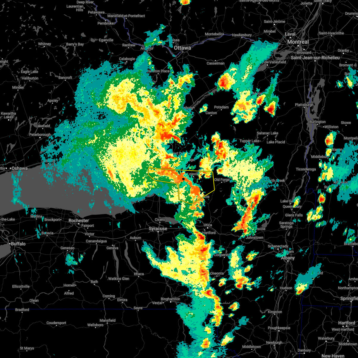
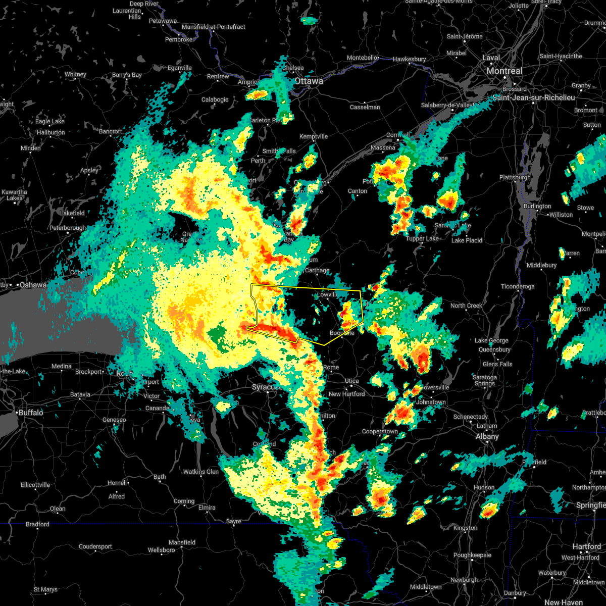
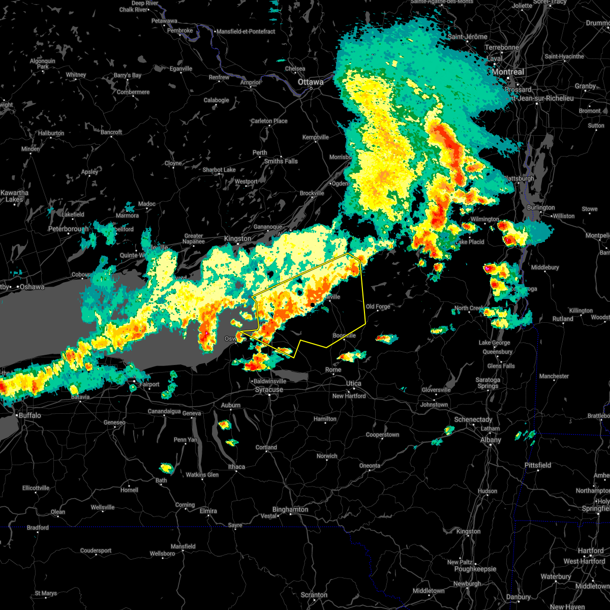
Hail Map for Henderson, NY
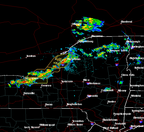
The Henderson, NY area has had 0 reports of on-the-ground hail by trained spotters, and has been under severe weather warnings 10 times during the past 12 months. Doppler radar has detected hail at or near Henderson, NY on 8 occasions, including 1 occasion during the past year.
| Name: | Henderson, NY |
| Where Located: | 55 miles N of Syracuse, NY |
| Map: | Google Map for Henderson, NY |
| Population: | 224 |
| Housing Units: | 118 |
| More Info: | Search Google for Henderson, NY |
0
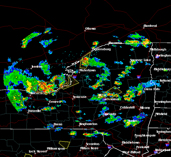
The Top Recent Hail Date for Henderson, NY is Saturday, August 12, 2023 (6th out of 8)

Hail and Wind Damage Spotted near Henderson, NY
| Date / Time | Report Details |
|---|---|
| 9/7/2023 7:57 PM EDT |
 At 756 pm edt, a severe thunderstorm was located 9 miles west of whetstone gulf state park, or 22 miles southeast of watertown, moving northeast at 35 mph (radar indicated). Hazards include 60 mph wind gusts. Expect damage to roofs, siding, and trees. locations impacted include, watertown, lowville, adams, dexter, glen park, adams center, barnes corners, whetstone gulf state park, southwick beach state park, and denmark. this includes interstate 81 between exits 39 and 47. hail threat, radar indicated max hail size, <. 75 in wind threat, radar indicated max wind gust, 60 mph. At 756 pm edt, a severe thunderstorm was located 9 miles west of whetstone gulf state park, or 22 miles southeast of watertown, moving northeast at 35 mph (radar indicated). Hazards include 60 mph wind gusts. Expect damage to roofs, siding, and trees. locations impacted include, watertown, lowville, adams, dexter, glen park, adams center, barnes corners, whetstone gulf state park, southwick beach state park, and denmark. this includes interstate 81 between exits 39 and 47. hail threat, radar indicated max hail size, <. 75 in wind threat, radar indicated max wind gust, 60 mph.
|
| 9/7/2023 7:28 PM EDT |
 At 728 pm edt, a severe thunderstorm was located near redfield, or 10 miles north of camden, moving northeast at 35 mph (radar indicated). Hazards include 60 mph wind gusts. expect damage to roofs, siding, and trees At 728 pm edt, a severe thunderstorm was located near redfield, or 10 miles north of camden, moving northeast at 35 mph (radar indicated). Hazards include 60 mph wind gusts. expect damage to roofs, siding, and trees
|
| 9/6/2023 11:43 PM EDT |
 At 1141 pm edt, a severe thunderstorm was located near adams center, or 11 miles southwest of watertown, moving northeast at 35 mph (radar indicated). Hazards include 60 mph wind gusts and penny size hail. Expect damage to roofs, siding, and trees. locations impacted include, watertown, adams, dexter, glen park, adams center, henderson harbor, barnes corners, southwick beach state park, sackets harbor, and henderson. this includes interstate 81 between exits 37 and 48. hail threat, radar indicated max hail size, 0. 75 in wind threat, radar indicated max wind gust, 60 mph. At 1141 pm edt, a severe thunderstorm was located near adams center, or 11 miles southwest of watertown, moving northeast at 35 mph (radar indicated). Hazards include 60 mph wind gusts and penny size hail. Expect damage to roofs, siding, and trees. locations impacted include, watertown, adams, dexter, glen park, adams center, henderson harbor, barnes corners, southwick beach state park, sackets harbor, and henderson. this includes interstate 81 between exits 37 and 48. hail threat, radar indicated max hail size, 0. 75 in wind threat, radar indicated max wind gust, 60 mph.
|
| 9/6/2023 11:24 PM EDT | Tree down on state rt 3 in ellisbur in jefferson county NY, 7.4 miles N of Henderson, NY |
| 9/6/2023 11:17 PM EDT |
 At 1115 pm edt, a severe thunderstorm was located 7 miles southwest of stony point, or 13 miles northwest of sandy island beach state park, moving northeast at 35 mph (radar indicated). Hazards include 60 mph wind gusts and penny size hail. expect damage to roofs, siding, and trees At 1115 pm edt, a severe thunderstorm was located 7 miles southwest of stony point, or 13 miles northwest of sandy island beach state park, moving northeast at 35 mph (radar indicated). Hazards include 60 mph wind gusts and penny size hail. expect damage to roofs, siding, and trees
|
| 8/12/2023 7:25 PM EDT |
 At 725 pm edt, a severe thunderstorm was located near adams, or 11 miles northeast of sandy island beach state park, moving east at 40 mph (radar indicated). Hazards include 60 mph wind gusts and quarter size hail. Hail damage to vehicles is expected. expect wind damage to roofs, siding, and trees. locations impacted include, watertown, sandy island beach state park, fort drum, stony point, carthage, pulaski, west carthage, adams, dexter, and redfield. This includes interstate 81 between exits 37 and 48. At 725 pm edt, a severe thunderstorm was located near adams, or 11 miles northeast of sandy island beach state park, moving east at 40 mph (radar indicated). Hazards include 60 mph wind gusts and quarter size hail. Hail damage to vehicles is expected. expect wind damage to roofs, siding, and trees. locations impacted include, watertown, sandy island beach state park, fort drum, stony point, carthage, pulaski, west carthage, adams, dexter, and redfield. This includes interstate 81 between exits 37 and 48.
|
| 8/12/2023 6:57 PM EDT |
 At 656 pm edt, a severe thunderstorm was located 8 miles west of stony point, or 20 miles northwest of sandy island beach state park, moving east at 40 mph (radar indicated). Hazards include 60 mph wind gusts and quarter size hail. Hail damage to vehicles is expected. Expect wind damage to roofs, siding, and trees. At 656 pm edt, a severe thunderstorm was located 8 miles west of stony point, or 20 miles northwest of sandy island beach state park, moving east at 40 mph (radar indicated). Hazards include 60 mph wind gusts and quarter size hail. Hail damage to vehicles is expected. Expect wind damage to roofs, siding, and trees.
|
| 8/7/2023 5:04 PM EDT |
 At 504 pm edt, a severe thunderstorm was located near clayton, or 13 miles northwest of fort drum, moving north at 30 mph (radar indicated). Hazards include 60 mph wind gusts and quarter size hail. Hail damage to vehicles is expected. expect wind damage to roofs, siding, and trees. locations impacted include, watertown, clayton, adams, dexter, glen park, redwood, adams center, henderson harbor, wellesley island state park, and sackets harbor. this includes interstate 81 between exits 41 and 52. hail threat, radar indicated max hail size, 1. 00 in wind threat, radar indicated max wind gust, 60 mph. At 504 pm edt, a severe thunderstorm was located near clayton, or 13 miles northwest of fort drum, moving north at 30 mph (radar indicated). Hazards include 60 mph wind gusts and quarter size hail. Hail damage to vehicles is expected. expect wind damage to roofs, siding, and trees. locations impacted include, watertown, clayton, adams, dexter, glen park, redwood, adams center, henderson harbor, wellesley island state park, and sackets harbor. this includes interstate 81 between exits 41 and 52. hail threat, radar indicated max hail size, 1. 00 in wind threat, radar indicated max wind gust, 60 mph.
|
| 8/7/2023 4:36 PM EDT |
 At 436 pm edt, a severe thunderstorm was located over dexter, or 7 miles west of watertown, moving north at 30 mph (radar indicated). Hazards include 60 mph wind gusts and quarter size hail. Hail damage to vehicles is expected. Expect wind damage to roofs, siding, and trees. At 436 pm edt, a severe thunderstorm was located over dexter, or 7 miles west of watertown, moving north at 30 mph (radar indicated). Hazards include 60 mph wind gusts and quarter size hail. Hail damage to vehicles is expected. Expect wind damage to roofs, siding, and trees.
|
| 7/13/2023 2:05 PM EDT |
 At 203 pm edt, severe thunderstorms were located along a line extending from clayton to near adams center to sandy island beach state park, moving east at 35 mph (radar indicated). Hazards include 60 mph wind gusts and quarter size hail. Minor damage to vehicles is possible. expect wind damage to trees and power lines. locations impacted include, watertown, sandy island beach state park, fort drum, stony point, carthage, pulaski, west carthage, clayton, adams, and dexter. this includes interstate 81 between exits 37 and 52. hail threat, radar indicated max hail size, 1. 00 in wind threat, radar indicated max wind gust, 60 mph. At 203 pm edt, severe thunderstorms were located along a line extending from clayton to near adams center to sandy island beach state park, moving east at 35 mph (radar indicated). Hazards include 60 mph wind gusts and quarter size hail. Minor damage to vehicles is possible. expect wind damage to trees and power lines. locations impacted include, watertown, sandy island beach state park, fort drum, stony point, carthage, pulaski, west carthage, clayton, adams, and dexter. this includes interstate 81 between exits 37 and 52. hail threat, radar indicated max hail size, 1. 00 in wind threat, radar indicated max wind gust, 60 mph.
|
| 7/13/2023 1:40 PM EDT |
 At 140 pm edt, severe thunderstorms were located along a line extending from 6 miles northwest of clayton to near stony point to near nine mile point, moving east at 40 mph (radar indicated). Hazards include 60 mph wind gusts and quarter size hail. Minor damage to vehicles is possible. Expect wind damage to trees and power lines. At 140 pm edt, severe thunderstorms were located along a line extending from 6 miles northwest of clayton to near stony point to near nine mile point, moving east at 40 mph (radar indicated). Hazards include 60 mph wind gusts and quarter size hail. Minor damage to vehicles is possible. Expect wind damage to trees and power lines.
|
| 4/5/2023 11:47 AM EDT |
 At 1145 am edt, a severe thunderstorm was located 7 miles northeast of barnes corners, or 8 miles southeast of watertown, moving east at 50 mph (radar indicated). Hazards include 60 mph wind gusts and quarter size hail. Minor damage to vehicles is possible. expect wind damage to trees and power lines. locations impacted include, watertown, sandy island beach state park, fort drum, west carthage, adams, dexter, glen park, herrings, adams center and henderson harbor. this includes interstate 81 between exits 37 and 48. hail threat, radar indicated max hail size, 1. 00 in wind threat, radar indicated max wind gust, 60 mph. At 1145 am edt, a severe thunderstorm was located 7 miles northeast of barnes corners, or 8 miles southeast of watertown, moving east at 50 mph (radar indicated). Hazards include 60 mph wind gusts and quarter size hail. Minor damage to vehicles is possible. expect wind damage to trees and power lines. locations impacted include, watertown, sandy island beach state park, fort drum, west carthage, adams, dexter, glen park, herrings, adams center and henderson harbor. this includes interstate 81 between exits 37 and 48. hail threat, radar indicated max hail size, 1. 00 in wind threat, radar indicated max wind gust, 60 mph.
|
| 4/5/2023 11:09 AM EDT |
 At 1108 am edt, a severe thunderstorm was located near stony point, or 16 miles northwest of sandy island beach state park, moving east at 50 mph (radar indicated). Hazards include 60 mph wind gusts and quarter size hail. Minor damage to vehicles is possible. Expect wind damage to trees and power lines. At 1108 am edt, a severe thunderstorm was located near stony point, or 16 miles northwest of sandy island beach state park, moving east at 50 mph (radar indicated). Hazards include 60 mph wind gusts and quarter size hail. Minor damage to vehicles is possible. Expect wind damage to trees and power lines.
|
| 8/29/2022 6:39 PM EDT |
 At 639 pm edt, severe thunderstorms were located along a line extending from cedar point state park to near sandy island beach state park, moving northeast at 45 mph (radar indicated). Hazards include 60 mph wind gusts. Expect damage to trees and power lines. locations impacted include, watertown, fort drum, sandy island beach state park, stony point, carthage, lowville, pulaski, west carthage, clayton and central square. this includes interstate 81 between exits 32 and 51. hail threat, radar indicated max hail size, <. 75 in wind threat, radar indicated max wind gust, 60 mph. At 639 pm edt, severe thunderstorms were located along a line extending from cedar point state park to near sandy island beach state park, moving northeast at 45 mph (radar indicated). Hazards include 60 mph wind gusts. Expect damage to trees and power lines. locations impacted include, watertown, fort drum, sandy island beach state park, stony point, carthage, lowville, pulaski, west carthage, clayton and central square. this includes interstate 81 between exits 32 and 51. hail threat, radar indicated max hail size, <. 75 in wind threat, radar indicated max wind gust, 60 mph.
|
| 8/29/2022 6:06 PM EDT |
 At 606 pm edt, severe thunderstorms were located along a line extending from 20 miles west of cedar point state park to 9 miles north of fair haven beach state park, moving northeast at 40 mph (radar indicated). Hazards include 60 mph wind gusts. expect damage to trees and power lines At 606 pm edt, severe thunderstorms were located along a line extending from 20 miles west of cedar point state park to 9 miles north of fair haven beach state park, moving northeast at 40 mph (radar indicated). Hazards include 60 mph wind gusts. expect damage to trees and power lines
|
| 7/28/2022 1:14 PM EDT |
 At 113 pm edt, a severe thunderstorm was located near henderson harbor, or 13 miles west of watertown, moving east at 40 mph (radar indicated). Hazards include 60 mph wind gusts and penny size hail. Expect damage to trees and power lines. locations impacted include, watertown, stony point, clayton, adams, dexter, glen park, adams center, henderson harbor, cedar point state park and southwick beach state park. this includes interstate 81 between exits 41 and 48. hail threat, radar indicated max hail size, 0. 75 in wind threat, radar indicated max wind gust, 60 mph. At 113 pm edt, a severe thunderstorm was located near henderson harbor, or 13 miles west of watertown, moving east at 40 mph (radar indicated). Hazards include 60 mph wind gusts and penny size hail. Expect damage to trees and power lines. locations impacted include, watertown, stony point, clayton, adams, dexter, glen park, adams center, henderson harbor, cedar point state park and southwick beach state park. this includes interstate 81 between exits 41 and 48. hail threat, radar indicated max hail size, 0. 75 in wind threat, radar indicated max wind gust, 60 mph.
|
| 7/28/2022 12:41 PM EDT |
 At 1240 pm edt, a severe thunderstorm was located 15 miles west of stony point, or 23 miles northwest of sandy island beach state park, moving northeast at 40 mph (radar indicated). Hazards include 60 mph wind gusts and penny size hail. expect damage to trees and power lines At 1240 pm edt, a severe thunderstorm was located 15 miles west of stony point, or 23 miles northwest of sandy island beach state park, moving northeast at 40 mph (radar indicated). Hazards include 60 mph wind gusts and penny size hail. expect damage to trees and power lines
|
| 6/16/2022 6:30 PM EDT |
 At 629 pm edt, a severe thunderstorm was located 7 miles southeast of mexico point state park, or 14 miles south of sandy island beach state park, moving east at 40 mph (radar indicated). Hazards include 60 mph wind gusts and quarter size hail. Minor damage to vehicles is possible. expect wind damage to trees and power lines. locations impacted include, oswego, fulton, sandy island beach state park, pulaski, central square, adams, redfield, selkirk shores state park, mexico point state park and adams center. This includes interstate 81 between exits 32 and 42. At 629 pm edt, a severe thunderstorm was located 7 miles southeast of mexico point state park, or 14 miles south of sandy island beach state park, moving east at 40 mph (radar indicated). Hazards include 60 mph wind gusts and quarter size hail. Minor damage to vehicles is possible. expect wind damage to trees and power lines. locations impacted include, oswego, fulton, sandy island beach state park, pulaski, central square, adams, redfield, selkirk shores state park, mexico point state park and adams center. This includes interstate 81 between exits 32 and 42.
|
| 6/16/2022 5:58 PM EDT |
 At 556 pm edt, a severe thunderstorm was located near fair haven beach state park, moving northeast at 40 mph (radar indicated). Hazards include ping pong ball size hail and 60 mph wind gusts. People and animals outdoors will be injured. expect hail damage to roofs, siding, windows, and vehicles. Expect wind damage to trees and power lines. At 556 pm edt, a severe thunderstorm was located near fair haven beach state park, moving northeast at 40 mph (radar indicated). Hazards include ping pong ball size hail and 60 mph wind gusts. People and animals outdoors will be injured. expect hail damage to roofs, siding, windows, and vehicles. Expect wind damage to trees and power lines.
|
| 5/16/2022 2:44 PM EDT |
 At 242 pm edt, severe thunderstorms were located along a line extending from near adams to near barnes corners to near whetstone gulf state park, moving northeast at 45 mph (radar indicated). Hazards include 60 mph wind gusts. Expect damage to trees and power lines. locations impacted include, stony point, lowville, adams, highmarket, adams center, henderson harbor, barnes corners, whetstone gulf state park, southwick beach state park and new bremen. this includes interstate 81 between exits 40 and 42. hail threat, radar indicated max hail size, <. 75 in wind threat, radar indicated max wind gust, 60 mph. At 242 pm edt, severe thunderstorms were located along a line extending from near adams to near barnes corners to near whetstone gulf state park, moving northeast at 45 mph (radar indicated). Hazards include 60 mph wind gusts. Expect damage to trees and power lines. locations impacted include, stony point, lowville, adams, highmarket, adams center, henderson harbor, barnes corners, whetstone gulf state park, southwick beach state park and new bremen. this includes interstate 81 between exits 40 and 42. hail threat, radar indicated max hail size, <. 75 in wind threat, radar indicated max wind gust, 60 mph.
|
| 5/16/2022 2:12 PM EDT |
 At 212 pm edt, severe thunderstorms were located along a line extending from mexico point state park to 5 miles southeast of pulaski to 5 miles south of redfield, moving northeast at 45 mph (radar indicated). Hazards include 60 mph wind gusts. expect damage to trees and power lines At 212 pm edt, severe thunderstorms were located along a line extending from mexico point state park to 5 miles southeast of pulaski to 5 miles south of redfield, moving northeast at 45 mph (radar indicated). Hazards include 60 mph wind gusts. expect damage to trees and power lines
|
| 7/20/2021 5:50 PM EDT |
 At 550 pm edt, severe thunderstorms were located along a line extending from 7 miles southwest of oswegatchie to near sandy island beach state park, moving east at 35 mph (radar indicated). Hazards include 60 mph wind gusts and penny size hail. Expect damage to roofs, siding, and trees. locations impacted include, watertown, sandy island beach state park, carthage, lowville, pulaski, west carthage, adams, redfield, herrings and selkirk shores state park. This includes interstate 81 between exits 34 and 44. At 550 pm edt, severe thunderstorms were located along a line extending from 7 miles southwest of oswegatchie to near sandy island beach state park, moving east at 35 mph (radar indicated). Hazards include 60 mph wind gusts and penny size hail. Expect damage to roofs, siding, and trees. locations impacted include, watertown, sandy island beach state park, carthage, lowville, pulaski, west carthage, adams, redfield, herrings and selkirk shores state park. This includes interstate 81 between exits 34 and 44.
|
| 7/20/2021 5:13 PM EDT |
 At 512 pm edt, severe thunderstorms were located along a line extending from 6 miles southwest of fowler to 13 miles west of stony point, moving east at 35 mph (radar indicated). Hazards include 60 mph wind gusts and penny size hail. expect damage to roofs, siding, and trees At 512 pm edt, severe thunderstorms were located along a line extending from 6 miles southwest of fowler to 13 miles west of stony point, moving east at 35 mph (radar indicated). Hazards include 60 mph wind gusts and penny size hail. expect damage to roofs, siding, and trees
|
| 7/13/2021 10:10 PM EDT |
 At 1009 pm edt, severe thunderstorms were located along a line extending from 6 miles south of redwood to near adams center to 8 miles west of camden, moving northeast at 55 mph (radar indicated). Hazards include 70 mph wind gusts and penny size hail. Expect considerable tree damage. damage is likely to mobile homes, roofs, and outbuildings. locations impacted include, watertown, sandy island beach state park, fort drum, stony point, carthage, pulaski, west carthage, clayton, central square and adams. This includes interstate 81 between exits 32 and 52. At 1009 pm edt, severe thunderstorms were located along a line extending from 6 miles south of redwood to near adams center to 8 miles west of camden, moving northeast at 55 mph (radar indicated). Hazards include 70 mph wind gusts and penny size hail. Expect considerable tree damage. damage is likely to mobile homes, roofs, and outbuildings. locations impacted include, watertown, sandy island beach state park, fort drum, stony point, carthage, pulaski, west carthage, clayton, central square and adams. This includes interstate 81 between exits 32 and 52.
|
| 7/13/2021 9:25 PM EDT |
 At 924 pm edt, severe thunderstorms were located along a line extending from 25 miles west of cedar point state park to 9 miles southwest of southwick beach state park to near skaneateles, moving northeast at 40 mph (radar indicated). Hazards include 70 mph wind gusts and quarter size hail. Minor damage to vehicles is possible. expect considerable tree damage. Wind damage is also likely to mobile homes, roofs, and outbuildings. At 924 pm edt, severe thunderstorms were located along a line extending from 25 miles west of cedar point state park to 9 miles southwest of southwick beach state park to near skaneateles, moving northeast at 40 mph (radar indicated). Hazards include 70 mph wind gusts and quarter size hail. Minor damage to vehicles is possible. expect considerable tree damage. Wind damage is also likely to mobile homes, roofs, and outbuildings.
|
| 7/8/2021 5:41 PM EDT |
 At 541 pm edt, a severe thunderstorm was located over adams center, or 7 miles southwest of watertown, moving northeast at 35 mph (radar indicated). Hazards include 60 mph wind gusts. Expect damage to roofs, siding, and trees. locations impacted include, watertown, fort drum, lowville, west carthage, adams, dexter, glen park, adams center, henderson harbor and barnes corners. This includes interstate 81 between exits 37 and 48. At 541 pm edt, a severe thunderstorm was located over adams center, or 7 miles southwest of watertown, moving northeast at 35 mph (radar indicated). Hazards include 60 mph wind gusts. Expect damage to roofs, siding, and trees. locations impacted include, watertown, fort drum, lowville, west carthage, adams, dexter, glen park, adams center, henderson harbor and barnes corners. This includes interstate 81 between exits 37 and 48.
|
| 7/8/2021 5:37 PM EDT |
 At 536 pm edt, a severe thunderstorm was located over adams center, or 11 miles southwest of watertown, moving northeast at 40 mph (radar indicated). Hazards include 60 mph wind gusts. Expect damage to roofs, siding, and trees. locations impacted include, watertown, fort drum, lowville, west carthage, adams, dexter, redfield, glen park, highmarket and adams center. This includes interstate 81 between exits 37 and 48. At 536 pm edt, a severe thunderstorm was located over adams center, or 11 miles southwest of watertown, moving northeast at 40 mph (radar indicated). Hazards include 60 mph wind gusts. Expect damage to roofs, siding, and trees. locations impacted include, watertown, fort drum, lowville, west carthage, adams, dexter, redfield, glen park, highmarket and adams center. This includes interstate 81 between exits 37 and 48.
|
| 7/8/2021 5:12 PM EDT |
 At 511 pm edt, a severe thunderstorm was located 8 miles east of sandy island beach state park, moving northeast at 35 mph (radar indicated). Hazards include 60 mph wind gusts. expect damage to roofs, siding, and trees At 511 pm edt, a severe thunderstorm was located 8 miles east of sandy island beach state park, moving northeast at 35 mph (radar indicated). Hazards include 60 mph wind gusts. expect damage to roofs, siding, and trees
|
| 6/21/2021 7:25 AM EDT |
 At 725 am edt, severe thunderstorms were located along a line extending from 15 miles southwest of cedar point state park to 8 miles south of pulaski, moving northeast at 65 mph (radar indicated). Hazards include 60 mph wind gusts and penny size hail. expect damage to roofs, siding, and trees At 725 am edt, severe thunderstorms were located along a line extending from 15 miles southwest of cedar point state park to 8 miles south of pulaski, moving northeast at 65 mph (radar indicated). Hazards include 60 mph wind gusts and penny size hail. expect damage to roofs, siding, and trees
|
| 6/14/2021 12:04 AM EDT |
 At 1203 am edt, severe thunderstorms were located along a line extending from near dexter to near adams, moving east at 40 mph (radar indicated). Hazards include 60 mph wind gusts and quarter size hail. Minor damage to vehicles is possible. Expect wind damage to roofs, siding, and trees. At 1203 am edt, severe thunderstorms were located along a line extending from near dexter to near adams, moving east at 40 mph (radar indicated). Hazards include 60 mph wind gusts and quarter size hail. Minor damage to vehicles is possible. Expect wind damage to roofs, siding, and trees.
|
| 11/15/2020 5:26 PM EST |
 At 525 pm est, severe thunderstorms were located along a line extending from 19 miles northwest of stony point to 7 miles east of chimney bluffs state park, moving northeast at 65 mph (radar indicated). Hazards include 70 mph wind gusts. Expect considerable tree damage. Damage is likely to mobile homes, roofs, and outbuildings. At 525 pm est, severe thunderstorms were located along a line extending from 19 miles northwest of stony point to 7 miles east of chimney bluffs state park, moving northeast at 65 mph (radar indicated). Hazards include 70 mph wind gusts. Expect considerable tree damage. Damage is likely to mobile homes, roofs, and outbuildings.
|
| 10/7/2020 1:02 PM EDT |
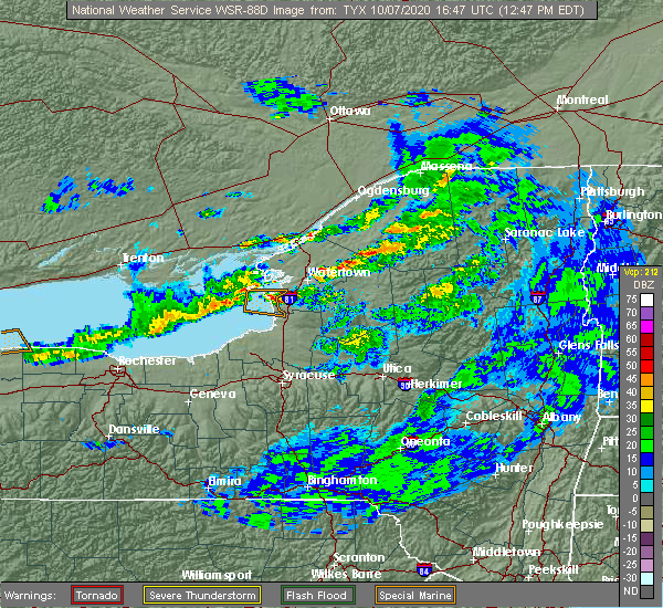 At 101 pm edt, a severe thunderstorm was located over adams, or 13 miles southwest of watertown, moving east at 30 mph (radar indicated). Hazards include 60 mph wind gusts and quarter size hail. Minor damage to vehicles is possible. Expect wind damage to roofs, siding, and trees. At 101 pm edt, a severe thunderstorm was located over adams, or 13 miles southwest of watertown, moving east at 30 mph (radar indicated). Hazards include 60 mph wind gusts and quarter size hail. Minor damage to vehicles is possible. Expect wind damage to roofs, siding, and trees.
|
| 7/11/2020 4:49 PM EDT |
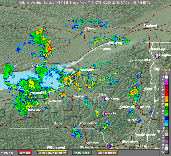 At 447 pm edt, a severe thunderstorm was located near pulaski, moving north at 20 mph (radar indicated). Hazards include 60 mph wind gusts. Expect damage to roofs, siding, and trees. locations impacted include, sandy island beach state park, stony point, pulaski, adams, henderson harbor, southwick beach state park, adams center, richland, henderson and lorraine. This includes interstate 81 between exits 36 and 41. At 447 pm edt, a severe thunderstorm was located near pulaski, moving north at 20 mph (radar indicated). Hazards include 60 mph wind gusts. Expect damage to roofs, siding, and trees. locations impacted include, sandy island beach state park, stony point, pulaski, adams, henderson harbor, southwick beach state park, adams center, richland, henderson and lorraine. This includes interstate 81 between exits 36 and 41.
|
| 7/11/2020 4:11 PM EDT |
 The national weather service in buffalo has issued a * severe thunderstorm warning for. southwestern jefferson county in central new york. north central oswego county in central new york. until 515 pm edt. At 411 pm edt, a severe thunderstorm was located near selkirk. The national weather service in buffalo has issued a * severe thunderstorm warning for. southwestern jefferson county in central new york. north central oswego county in central new york. until 515 pm edt. At 411 pm edt, a severe thunderstorm was located near selkirk.
|
| 8/21/2019 7:42 AM EDT |
 A severe thunderstorm warning remains in effect until 815 am edt for jefferson and northern lewis counties. at 741 am edt, a severe thunderstorm was located near watertown, moving north at 40 mph. hazard. 60 mph wind gusts. source. Radar indicated. A severe thunderstorm warning remains in effect until 815 am edt for jefferson and northern lewis counties. at 741 am edt, a severe thunderstorm was located near watertown, moving north at 40 mph. hazard. 60 mph wind gusts. source. Radar indicated.
|
| 8/21/2019 6:58 AM EDT |
 At 657 am edt, a severe thunderstorm was located over sandy island beach state park, moving northeast at 45 mph (radar indicated). Hazards include 60 mph wind gusts. expect damage to roofs, siding, and trees At 657 am edt, a severe thunderstorm was located over sandy island beach state park, moving northeast at 45 mph (radar indicated). Hazards include 60 mph wind gusts. expect damage to roofs, siding, and trees
|
| 8/8/2019 1:50 PM EDT |
 At 150 pm edt, severe thunderstorms were located along a line extending from near oswego to near lodi, moving east at 40 mph (radar indicated). Hazards include 60 mph wind gusts and penny size hail. expect damage to roofs, siding, and trees At 150 pm edt, severe thunderstorms were located along a line extending from near oswego to near lodi, moving east at 40 mph (radar indicated). Hazards include 60 mph wind gusts and penny size hail. expect damage to roofs, siding, and trees
|
| 8/6/2019 3:34 PM EDT |
 The national weather service in buffalo has issued a * severe thunderstorm warning for. southern jefferson county in central new york. southern lewis county in central new york. northeastern oswego county in central new york. Until 415 pm edt. The national weather service in buffalo has issued a * severe thunderstorm warning for. southern jefferson county in central new york. southern lewis county in central new york. northeastern oswego county in central new york. Until 415 pm edt.
|
| 5/25/2019 8:21 PM EDT |
 At 821 pm edt, severe thunderstorms were located along a line extending from 7 miles north of stony point to near fair haven beach state park, moving east at 35 mph (radar indicated). Hazards include 70 mph wind gusts and penny size hail. Expect considerable tree damage. damage is likely to mobile homes, roofs, and outbuildings. locations impacted include, watertown, oswego, fulton, sandy island beach state park, fort drum, lysander, stony point, carthage, pulaski and west carthage. This includes interstate 81 between exits 32 and 48. At 821 pm edt, severe thunderstorms were located along a line extending from 7 miles north of stony point to near fair haven beach state park, moving east at 35 mph (radar indicated). Hazards include 70 mph wind gusts and penny size hail. Expect considerable tree damage. damage is likely to mobile homes, roofs, and outbuildings. locations impacted include, watertown, oswego, fulton, sandy island beach state park, fort drum, lysander, stony point, carthage, pulaski and west carthage. This includes interstate 81 between exits 32 and 48.
|
| 5/25/2019 8:08 PM EDT |
 At 808 pm edt, severe thunderstorms were located along a line extending from 11 miles northwest of stony point to near fair haven beach state park, moving east at 45 mph (radar indicated). Hazards include 60 mph wind gusts and penny size hail. expect damage to roofs, siding, and trees At 808 pm edt, severe thunderstorms were located along a line extending from 11 miles northwest of stony point to near fair haven beach state park, moving east at 45 mph (radar indicated). Hazards include 60 mph wind gusts and penny size hail. expect damage to roofs, siding, and trees
|
| 5/23/2019 6:55 PM EDT |
 At 654 pm edt, severe thunderstorms were located along a line extending from near stony point to 10 miles northwest of oswego, moving east at 50 mph (radar indicated). Hazards include 60 mph wind gusts and penny size hail. expect damage to roofs, siding, and trees At 654 pm edt, severe thunderstorms were located along a line extending from near stony point to 10 miles northwest of oswego, moving east at 50 mph (radar indicated). Hazards include 60 mph wind gusts and penny size hail. expect damage to roofs, siding, and trees
|
| 5/19/2019 1:52 PM EDT |
 At 151 pm edt, a severe thunderstorm was located 10 miles west of dexter, or 17 miles west of watertown, moving northeast at 55 mph (radar indicated). Hazards include 60 mph wind gusts. expect damage to roofs, siding, and trees At 151 pm edt, a severe thunderstorm was located 10 miles west of dexter, or 17 miles west of watertown, moving northeast at 55 mph (radar indicated). Hazards include 60 mph wind gusts. expect damage to roofs, siding, and trees
|
| 8/17/2018 10:17 PM EDT |
 At 1017 pm edt, a severe thunderstorm was located near southwick beach state park, moving east at 25 mph (radar indicated). Hazards include 70 mph wind gusts. Expect considerable tree damage. damage is likely to mobile homes, roofs, and outbuildings. Locations impacted include, sandy island beach state park, stony point, pulaski, adams, redfield, adams center, henderson harbor and southwick beach state park. At 1017 pm edt, a severe thunderstorm was located near southwick beach state park, moving east at 25 mph (radar indicated). Hazards include 70 mph wind gusts. Expect considerable tree damage. damage is likely to mobile homes, roofs, and outbuildings. Locations impacted include, sandy island beach state park, stony point, pulaski, adams, redfield, adams center, henderson harbor and southwick beach state park.
|
| 8/17/2018 9:49 PM EDT |
 At 949 pm edt, a severe thunderstorm was located 10 miles north of nine mile point, or 10 miles west of sandy island beach state park, moving east at 30 mph (radar indicated). Hazards include 60 mph wind gusts. expect damage to roofs, siding, and trees At 949 pm edt, a severe thunderstorm was located 10 miles north of nine mile point, or 10 miles west of sandy island beach state park, moving east at 30 mph (radar indicated). Hazards include 60 mph wind gusts. expect damage to roofs, siding, and trees
|
| 8/15/2018 4:38 PM EDT |
 At 438 pm edt, a severe thunderstorm was located 7 miles west of cedar point state park, or 26 miles northwest of watertown, moving southeast at 20 mph (radar indicated). Hazards include golf ball size hail and 60 mph wind gusts. People and animals outdoors will be injured. expect hail damage to roofs, siding, windows, and vehicles. expect wind damage to roofs, siding, and trees. Locations impacted include, stony point, clayton, dexter, glen park, henderson harbor, cedar point state park, sackets harbor and henderson. At 438 pm edt, a severe thunderstorm was located 7 miles west of cedar point state park, or 26 miles northwest of watertown, moving southeast at 20 mph (radar indicated). Hazards include golf ball size hail and 60 mph wind gusts. People and animals outdoors will be injured. expect hail damage to roofs, siding, windows, and vehicles. expect wind damage to roofs, siding, and trees. Locations impacted include, stony point, clayton, dexter, glen park, henderson harbor, cedar point state park, sackets harbor and henderson.
|
| 8/15/2018 4:29 PM EDT |
 At 429 pm edt, a severe thunderstorm was located 10 miles west of cedar point state park, or 29 miles northwest of watertown, moving southeast at 20 mph (radar indicated). Hazards include 60 mph wind gusts and quarter size hail. Minor damage to vehicles is possible. Expect wind damage to roofs, siding, and trees. At 429 pm edt, a severe thunderstorm was located 10 miles west of cedar point state park, or 29 miles northwest of watertown, moving southeast at 20 mph (radar indicated). Hazards include 60 mph wind gusts and quarter size hail. Minor damage to vehicles is possible. Expect wind damage to roofs, siding, and trees.
|
| 8/7/2018 5:04 AM EDT |
 At 503 am edt, severe thunderstorms were located along a line extending from 8 miles southeast of clayton to near glen park to near adams, moving east at 50 mph (radar indicated). Hazards include 60 mph wind gusts. Expect damage to roofs, siding, and trees. locations impacted include, watertown, fort drum, clayton, adams, dexter, glen park, redwood and kring point state park. This includes interstate 81 between exits 39 and 52. At 503 am edt, severe thunderstorms were located along a line extending from 8 miles southeast of clayton to near glen park to near adams, moving east at 50 mph (radar indicated). Hazards include 60 mph wind gusts. Expect damage to roofs, siding, and trees. locations impacted include, watertown, fort drum, clayton, adams, dexter, glen park, redwood and kring point state park. This includes interstate 81 between exits 39 and 52.
|
| 8/7/2018 4:35 AM EDT |
 At 434 am edt, severe thunderstorms were located along a line extending from 13 miles northwest of henderson harbor to 7 miles southwest of stony point, moving northeast at 40 mph (radar indicated). Hazards include 60 mph wind gusts. expect damage to roofs, siding, and trees At 434 am edt, severe thunderstorms were located along a line extending from 13 miles northwest of henderson harbor to 7 miles southwest of stony point, moving northeast at 40 mph (radar indicated). Hazards include 60 mph wind gusts. expect damage to roofs, siding, and trees
|
| 7/17/2018 1:46 AM EDT |
 At 145 am edt, a severe thunderstorm was located over glen park, or near watertown, moving east at 30 mph (radar indicated). Hazards include 60 mph wind gusts. Expect damage to roofs, siding, and trees. Locations impacted include, watertown, fort drum, carthage, west carthage, dexter, glen park, herrings and henderson harbor. At 145 am edt, a severe thunderstorm was located over glen park, or near watertown, moving east at 30 mph (radar indicated). Hazards include 60 mph wind gusts. Expect damage to roofs, siding, and trees. Locations impacted include, watertown, fort drum, carthage, west carthage, dexter, glen park, herrings and henderson harbor.
|
| 7/17/2018 1:19 AM EDT |
 At 118 am edt, a severe thunderstorm was located near henderson harbor, or 16 miles west of watertown, moving east at 30 mph (radar indicated). Hazards include 60 mph wind gusts. expect damage to roofs, siding, and trees At 118 am edt, a severe thunderstorm was located near henderson harbor, or 16 miles west of watertown, moving east at 30 mph (radar indicated). Hazards include 60 mph wind gusts. expect damage to roofs, siding, and trees
|
| 6/13/2018 7:08 PM EDT |
 At 708 pm edt, severe thunderstorms were located along a line extending from 6 miles southeast of de kalb to near west carthage, moving east at 65 mph (radar indicated). Hazards include 60 mph wind gusts and penny size hail. Expect damage to roofs, siding, and trees. Locations impacted include, watertown, fort drum, stony point, adams, dexter, glen park, adams center and henderson harbor. At 708 pm edt, severe thunderstorms were located along a line extending from 6 miles southeast of de kalb to near west carthage, moving east at 65 mph (radar indicated). Hazards include 60 mph wind gusts and penny size hail. Expect damage to roofs, siding, and trees. Locations impacted include, watertown, fort drum, stony point, adams, dexter, glen park, adams center and henderson harbor.
|
| 6/13/2018 6:40 PM EDT |
 At 557 pm edt, severe thunderstorms were located along a line extending from 24 miles northwest of wellesley island state park to 42 miles west of stony point, moving east at 65 mph (radar indicated). Hazards include 60 mph wind gusts and penny size hail. expect damage to roofs, siding, and trees At 557 pm edt, severe thunderstorms were located along a line extending from 24 miles northwest of wellesley island state park to 42 miles west of stony point, moving east at 65 mph (radar indicated). Hazards include 60 mph wind gusts and penny size hail. expect damage to roofs, siding, and trees
|
| 6/13/2018 5:57 PM EDT |
 At 557 pm edt, severe thunderstorms were located along a line extending from 24 miles northwest of wellesley island state park to 42 miles west of stony point, moving east at 65 mph (radar indicated). Hazards include 60 mph wind gusts and penny size hail. expect damage to roofs, siding, and trees At 557 pm edt, severe thunderstorms were located along a line extending from 24 miles northwest of wellesley island state park to 42 miles west of stony point, moving east at 65 mph (radar indicated). Hazards include 60 mph wind gusts and penny size hail. expect damage to roofs, siding, and trees
|
| 5/4/2018 5:32 PM EDT |
 At 531 pm edt, a severe thunderstorm was located near sandy island beach state park, moving northeast at 70 mph (radar indicated). Hazards include 70 mph wind gusts. Expect considerable tree damage. Damage is likely to mobile homes, roofs, and outbuildings. At 531 pm edt, a severe thunderstorm was located near sandy island beach state park, moving northeast at 70 mph (radar indicated). Hazards include 70 mph wind gusts. Expect considerable tree damage. Damage is likely to mobile homes, roofs, and outbuildings.
|
| 8/22/2017 5:29 PM EDT |
 At 528 pm edt, severe thunderstorms were located along a line extending from near edwardsville to near glen park to 7 miles west of stony point, moving east at 40 mph (radar indicated). Hazards include 60 mph wind gusts. expect wind damage to trees and power lines At 528 pm edt, severe thunderstorms were located along a line extending from near edwardsville to near glen park to 7 miles west of stony point, moving east at 40 mph (radar indicated). Hazards include 60 mph wind gusts. expect wind damage to trees and power lines
|
| 8/22/2017 2:53 PM EDT |
 The severe thunderstorm warning for jefferson, central lewis and northern oswego counties will expire at 300 pm edt, the storms which prompted the warning have moved out of the area. therefore the warning will be allowed to expire. remember, a severe thunderstorm warning still remains in effect for far eastern jefferson, eastern oswego and all of lewis county. a tornado watch remains in effect until 900 pm edt for central new york. The severe thunderstorm warning for jefferson, central lewis and northern oswego counties will expire at 300 pm edt, the storms which prompted the warning have moved out of the area. therefore the warning will be allowed to expire. remember, a severe thunderstorm warning still remains in effect for far eastern jefferson, eastern oswego and all of lewis county. a tornado watch remains in effect until 900 pm edt for central new york.
|
| 8/22/2017 2:18 PM EDT |
 At 218 pm edt, severe thunderstorms were located along a line extending from 11 miles southwest of fowler to near barnes corners to near oswego, moving east at 35 mph (radar indicated). Hazards include 70 mph wind gusts. Expect considerable tree damage. damage is likely to mobile homes, roofs, and outbuildings. locations impacted include, watertown, oswego, sandy island beach state park, fort drum, stony point, carthage, pulaski and west carthage. this includes interstate 81 between exits 34 and 48. A tornado watch remains in effect until 900 pm edt for central new york. At 218 pm edt, severe thunderstorms were located along a line extending from 11 miles southwest of fowler to near barnes corners to near oswego, moving east at 35 mph (radar indicated). Hazards include 70 mph wind gusts. Expect considerable tree damage. damage is likely to mobile homes, roofs, and outbuildings. locations impacted include, watertown, oswego, sandy island beach state park, fort drum, stony point, carthage, pulaski and west carthage. this includes interstate 81 between exits 34 and 48. A tornado watch remains in effect until 900 pm edt for central new york.
|
| 8/22/2017 1:53 PM EDT |
 At 153 pm edt, severe thunderstorms were located along a line extending from 7 miles northwest of fort drum to near adams to 10 miles northwest of fair haven beach state park, moving east at 35 mph (radar indicated). Hazards include 60 mph wind gusts. expect wind damage to trees and power lines At 153 pm edt, severe thunderstorms were located along a line extending from 7 miles northwest of fort drum to near adams to 10 miles northwest of fair haven beach state park, moving east at 35 mph (radar indicated). Hazards include 60 mph wind gusts. expect wind damage to trees and power lines
|
| 8/4/2017 5:51 PM EDT |
 At 550 pm edt, a severe thunderstorm was located over sandy island beach state park, moving northeast at 35 mph (radar indicated). Hazards include 60 mph wind gusts and quarter size hail. Minor damage to vehicles is possible. Expect wind damage to trees and power lines. At 550 pm edt, a severe thunderstorm was located over sandy island beach state park, moving northeast at 35 mph (radar indicated). Hazards include 60 mph wind gusts and quarter size hail. Minor damage to vehicles is possible. Expect wind damage to trees and power lines.
|
| 8/4/2017 4:27 PM EDT |
 At 427 pm edt, a severe thunderstorm was located near oswego, moving northeast at 40 mph (radar indicated). Hazards include 60 mph wind gusts and quarter size hail. Minor damage to vehicles is possible. Expect wind damage to trees and power lines. At 427 pm edt, a severe thunderstorm was located near oswego, moving northeast at 40 mph (radar indicated). Hazards include 60 mph wind gusts and quarter size hail. Minor damage to vehicles is possible. Expect wind damage to trees and power lines.
|
| 5/1/2017 6:22 PM EDT |
 At 621 pm edt, severe thunderstorms were located along a line extending from near wellesley island state park to watertown to 7 miles west of redfield, moving east at 60 mph (radar indicated). Hazards include 70 mph wind gusts. Expect considerable tree damage. damage is likely to mobile homes, roofs, and outbuildings. while not immediately likely, a tornado is possible with this storm. locations impacted include, watertown, sandy island beach state park, stony point, pulaski, clayton, adams, dexter and glen park. this includes interstate 81 between exits 36 and 48, and between exits 50 and 51. A tornado watch remains in effect until 1000 pm edt for central new york. At 621 pm edt, severe thunderstorms were located along a line extending from near wellesley island state park to watertown to 7 miles west of redfield, moving east at 60 mph (radar indicated). Hazards include 70 mph wind gusts. Expect considerable tree damage. damage is likely to mobile homes, roofs, and outbuildings. while not immediately likely, a tornado is possible with this storm. locations impacted include, watertown, sandy island beach state park, stony point, pulaski, clayton, adams, dexter and glen park. this includes interstate 81 between exits 36 and 48, and between exits 50 and 51. A tornado watch remains in effect until 1000 pm edt for central new york.
|
| 5/1/2017 6:01 PM EDT |
 At 600 pm edt, severe thunderstorms were located along a line extending from 10 miles west of cedar point state park to near henderson harbor to near mexico point state park, moving northeast at 45 mph (radar indicated). Hazards include 70 mph wind gusts. Expect considerable tree damage. damage is likely to mobile homes, roofs, and outbuildings. locations impacted include, watertown, sandy island beach state park, stony point, pulaski, clayton, adams, dexter and glen park. this includes interstate 81 between exits 35 and 48, and between exits 50 and 52. A tornado watch remains in effect until 1000 pm edt for central new york. At 600 pm edt, severe thunderstorms were located along a line extending from 10 miles west of cedar point state park to near henderson harbor to near mexico point state park, moving northeast at 45 mph (radar indicated). Hazards include 70 mph wind gusts. Expect considerable tree damage. damage is likely to mobile homes, roofs, and outbuildings. locations impacted include, watertown, sandy island beach state park, stony point, pulaski, clayton, adams, dexter and glen park. this includes interstate 81 between exits 35 and 48, and between exits 50 and 52. A tornado watch remains in effect until 1000 pm edt for central new york.
|
| 5/1/2017 5:36 PM EDT |
 At 536 pm edt, severe thunderstorms were located along a line extending from 26 miles west of cedar point state park to 15 miles southwest of stony point to near fair haven beach state park, moving east at 60 mph (radar indicated). Hazards include 70 mph wind gusts. Expect considerable tree damage. Damage is likely to mobile homes, roofs, and outbuildings. At 536 pm edt, severe thunderstorms were located along a line extending from 26 miles west of cedar point state park to 15 miles southwest of stony point to near fair haven beach state park, moving east at 60 mph (radar indicated). Hazards include 70 mph wind gusts. Expect considerable tree damage. Damage is likely to mobile homes, roofs, and outbuildings.
|
| 10/17/2016 7:56 PM EDT |
 The severe thunderstorm warning for southwestern lewis, south central jefferson and northeastern oswego counties will expire at 800 pm edt, the storm which prompted the warning has weakened below severe limits, and no longer pose an immediate threat to life or property. therefore, the warning will be allowed to expire. The severe thunderstorm warning for southwestern lewis, south central jefferson and northeastern oswego counties will expire at 800 pm edt, the storm which prompted the warning has weakened below severe limits, and no longer pose an immediate threat to life or property. therefore, the warning will be allowed to expire.
|
| 10/17/2016 7:28 PM EDT |
 At 727 pm edt, a severe thunderstorm was located near adams, or 14 miles northeast of sandy island beach state park, moving east at 55 mph (radar indicated). Hazards include 60 mph wind gusts. Expect damage to roofs. siding. and trees. locations impacted include, sandy island beach state park, lowville, pulaski, adams, redfield, highmarket, barnes corners and southwick beach state park. This includes interstate 81 between exits 37 and 43. At 727 pm edt, a severe thunderstorm was located near adams, or 14 miles northeast of sandy island beach state park, moving east at 55 mph (radar indicated). Hazards include 60 mph wind gusts. Expect damage to roofs. siding. and trees. locations impacted include, sandy island beach state park, lowville, pulaski, adams, redfield, highmarket, barnes corners and southwick beach state park. This includes interstate 81 between exits 37 and 43.
|
| 10/17/2016 6:55 PM EDT |
 The national weather service in buffalo has issued a * severe thunderstorm warning for. southwestern lewis county in central new york. southwestern jefferson county in central new york. northeastern oswego county in central new york. Until 800 pm edt. The national weather service in buffalo has issued a * severe thunderstorm warning for. southwestern lewis county in central new york. southwestern jefferson county in central new york. northeastern oswego county in central new york. Until 800 pm edt.
|
| 9/10/2016 11:42 PM EDT |
 At 1140 pm edt, a line of severe thunderstorms was located near mexico point state park, or 11 miles east of oswego, to henderson bay, moving northeast at 45 mph (radar indicated). Hazards include 60 mph wind gusts. Expect damage to roofs. siding. And trees. At 1140 pm edt, a line of severe thunderstorms was located near mexico point state park, or 11 miles east of oswego, to henderson bay, moving northeast at 45 mph (radar indicated). Hazards include 60 mph wind gusts. Expect damage to roofs. siding. And trees.
|
| 6/20/2016 10:11 PM EDT |
 At 1011 pm edt, severe thunderstorms were located along a line extending from fort drum to adams center, moving east at 45 mph (radar indicated). Hazards include 70 mph wind gusts and quarter size hail. Hail damage to vehicles is expected. expect considerable tree damage. wind damage is also likely to mobile homes, roofs, and outbuildings. Locations impacted include, watertown, fort drum, stony point, adams, dexter, glen park, henderson harbor and adams center. At 1011 pm edt, severe thunderstorms were located along a line extending from fort drum to adams center, moving east at 45 mph (radar indicated). Hazards include 70 mph wind gusts and quarter size hail. Hail damage to vehicles is expected. expect considerable tree damage. wind damage is also likely to mobile homes, roofs, and outbuildings. Locations impacted include, watertown, fort drum, stony point, adams, dexter, glen park, henderson harbor and adams center.
|
| 6/20/2016 9:53 PM EDT |
 At 953 pm edt, severe thunderstorms were located along a line extending from 8 miles north of fort drum to dexter, moving east at 95 mph (radar indicated). Hazards include 70 mph wind gusts and quarter size hail. Hail damage to vehicles is expected. expect considerable tree damage. Wind damage is also likely to mobile homes, roofs, and outbuildings. At 953 pm edt, severe thunderstorms were located along a line extending from 8 miles north of fort drum to dexter, moving east at 95 mph (radar indicated). Hazards include 70 mph wind gusts and quarter size hail. Hail damage to vehicles is expected. expect considerable tree damage. Wind damage is also likely to mobile homes, roofs, and outbuildings.
|
| 6/11/2016 8:34 AM EDT |
 At 833 am edt, severe thunderstorms were located along a line extending from 8 miles north of glen park to near dexter to 6 miles northwest of stony point, moving east at 60 mph (radar indicated). Hazards include 60 mph wind gusts. Expect damage to roofs. siding. And trees. At 833 am edt, severe thunderstorms were located along a line extending from 8 miles north of glen park to near dexter to 6 miles northwest of stony point, moving east at 60 mph (radar indicated). Hazards include 60 mph wind gusts. Expect damage to roofs. siding. And trees.
|
| 6/10/2015 9:20 PM EDT |
 A severe thunderstorm warning remains in effect until 945 pm edt for jefferson county. at 920 pm edt. doppler radar indicated a line of severe thunderstorms capable of producing damaging winds in excess of 60 mph. these storms were located along a line extending from near fort drum to near adams. Moving east at 50 mph. A severe thunderstorm warning remains in effect until 945 pm edt for jefferson county. at 920 pm edt. doppler radar indicated a line of severe thunderstorms capable of producing damaging winds in excess of 60 mph. these storms were located along a line extending from near fort drum to near adams. Moving east at 50 mph.
|
| 6/10/2015 8:48 PM EDT |
 At 847 pm edt, doppler radar indicated a line of severe thunderstorms capable of producing damaging winds in excess of 60 mph. these storms were located along a line extending from 7 miles southwest of cedar point state park to 12 miles west of stony point, and moving east at 45 mph. At 847 pm edt, doppler radar indicated a line of severe thunderstorms capable of producing damaging winds in excess of 60 mph. these storms were located along a line extending from 7 miles southwest of cedar point state park to 12 miles west of stony point, and moving east at 45 mph.
|
| 1/1/0001 12:00 AM | Trees down in jefferson county NY, 0.4 miles SW of Henderson, NY |
Hail Maps for Henderson, NY


Connect with Interactive Hail Maps