

Hail Map for Kanarraville, UT
The Kanarraville, UT area has had 0 reports of on-the-ground hail by trained spotters, and has been under severe weather warnings 7 times during the past 12 months. Doppler radar has detected hail at or near Kanarraville, UT on 9 occasions, including 1 occasion during the past year.
| Name: | Kanarraville, UT |
| Where Located: | 37 miles NE of Saint George, UT |
| Map: | Google Map for Kanarraville, UT |
| Population: | 355 |
| Housing Units: | 172 |
| More Info: | Search Google for Kanarraville, UT |
5
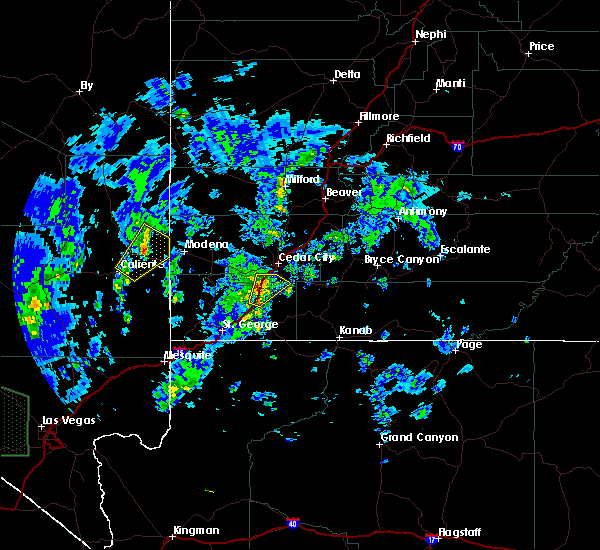
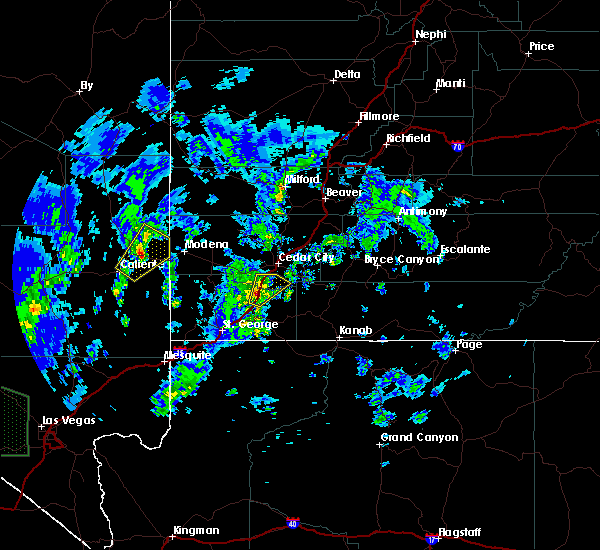
The Top Recent Hail Date for Kanarraville, UT is Thursday, June 15, 2023 (4th out of 9)

Hail and Wind Damage Spotted near Kanarraville, UT
| Date / Time | Report Details |
|---|---|
| 8/31/2023 10:44 PM MDT |
 At 1043 pm mdt, a severe thunderstorm was located near enoch, or 8 miles northeast of cedar city, moving northeast at 35 mph (radar indicated). Hazards include 60 mph wind gusts and penny size hail. Expect damage to roofs, siding, and trees. locations impacted include, cedar city, enoch, parowan, paragonah, cedar breaks national monument, summit, kanarraville, brian head and hamilton fort. this includes the following highways, interstate 15 between mile markers 46 and 82. utah route 56 between mile markers 43 and 61. hail threat, radar indicated max hail size, 0. 75 in wind threat, radar indicated max wind gust, 60 mph. At 1043 pm mdt, a severe thunderstorm was located near enoch, or 8 miles northeast of cedar city, moving northeast at 35 mph (radar indicated). Hazards include 60 mph wind gusts and penny size hail. Expect damage to roofs, siding, and trees. locations impacted include, cedar city, enoch, parowan, paragonah, cedar breaks national monument, summit, kanarraville, brian head and hamilton fort. this includes the following highways, interstate 15 between mile markers 46 and 82. utah route 56 between mile markers 43 and 61. hail threat, radar indicated max hail size, 0. 75 in wind threat, radar indicated max wind gust, 60 mph.
|
| 8/31/2023 10:21 PM MDT |
 At 1019 pm mdt, a severe thunderstorm was located over cedar city, moving northeast at 35 mph (radar indicated and surface observation confirmed. at 10:10 pm mdt, the cedar city municipal airport recorded a wind gust to 61 mph). Hazards include 60 mph wind gusts and penny size hail. expect damage to roofs, siding, and trees At 1019 pm mdt, a severe thunderstorm was located over cedar city, moving northeast at 35 mph (radar indicated and surface observation confirmed. at 10:10 pm mdt, the cedar city municipal airport recorded a wind gust to 61 mph). Hazards include 60 mph wind gusts and penny size hail. expect damage to roofs, siding, and trees
|
| 8/22/2023 6:25 PM MDT |
 At 625 pm mdt, a severe thunderstorm was located 7 miles north of la verkin, or 13 miles west of zion national park, moving northeast at 30 mph (radar indicated). Hazards include 60 mph wind gusts and quarter size hail. Hail damage to vehicles is expected. expect wind damage to roofs, siding, and trees. locations impacted include, zion national park, la verkin, new harmony, toquerville, kanarraville, pintura and kolob canyon. this includes interstate 15 between mile markers 26 and 50. hail threat, radar indicated max hail size, 1. 00 in wind threat, radar indicated max wind gust, 60 mph. At 625 pm mdt, a severe thunderstorm was located 7 miles north of la verkin, or 13 miles west of zion national park, moving northeast at 30 mph (radar indicated). Hazards include 60 mph wind gusts and quarter size hail. Hail damage to vehicles is expected. expect wind damage to roofs, siding, and trees. locations impacted include, zion national park, la verkin, new harmony, toquerville, kanarraville, pintura and kolob canyon. this includes interstate 15 between mile markers 26 and 50. hail threat, radar indicated max hail size, 1. 00 in wind threat, radar indicated max wind gust, 60 mph.
|
| 8/22/2023 6:10 PM MDT |
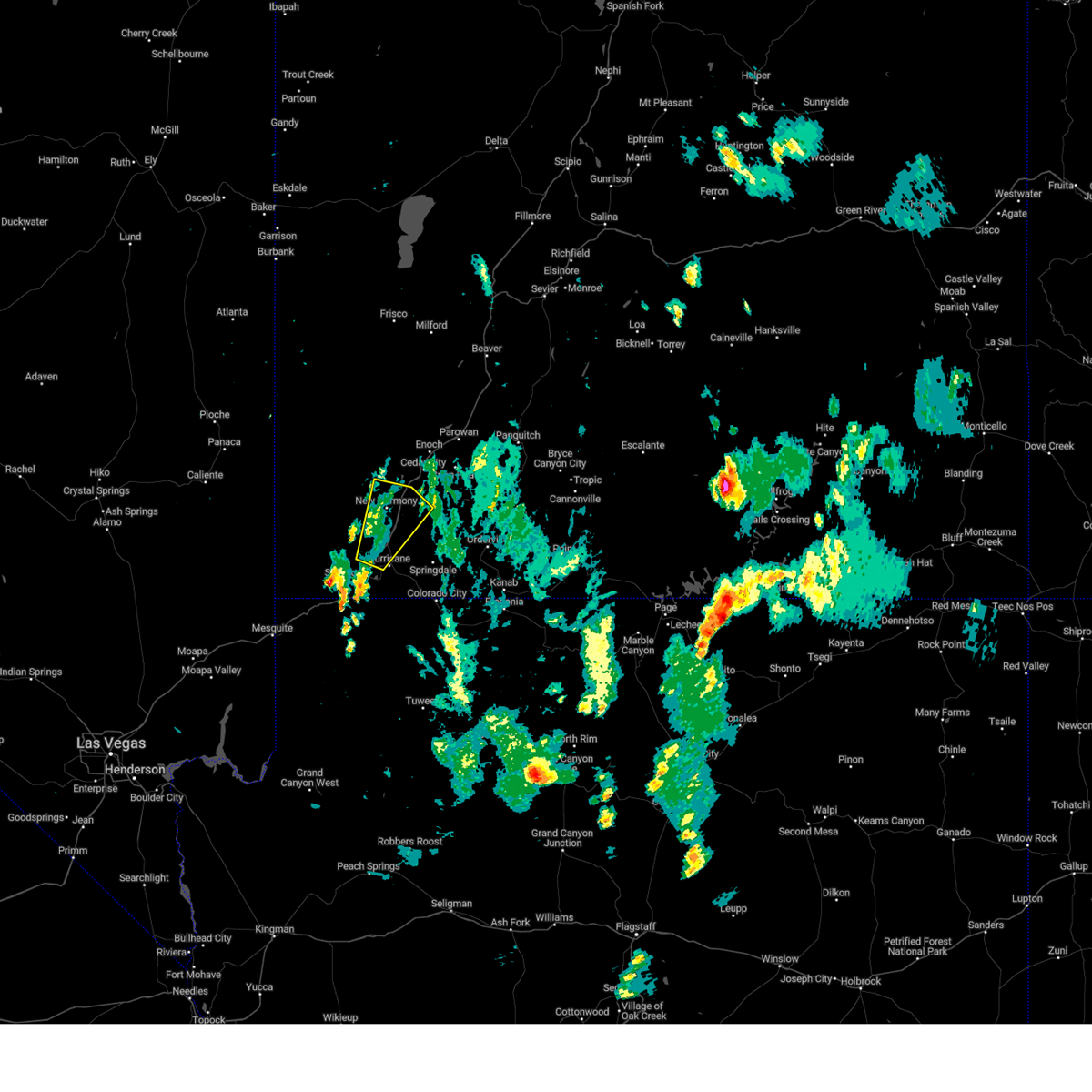 At 609 pm mdt, a severe thunderstorm was located near quail creek state park, or 18 miles west of zion national park, moving northeast at 30 mph (radar indicated). Hazards include 60 mph wind gusts and quarter size hail. Hail damage to vehicles is expected. Expect wind damage to roofs, siding, and trees. At 609 pm mdt, a severe thunderstorm was located near quail creek state park, or 18 miles west of zion national park, moving northeast at 30 mph (radar indicated). Hazards include 60 mph wind gusts and quarter size hail. Hail damage to vehicles is expected. Expect wind damage to roofs, siding, and trees.
|
| 6/15/2023 2:58 PM MDT |
 The severe thunderstorm warning for northeastern washington and south central iron counties will expire at 300 pm mdt, the storm which prompted the warning has weakened below severe limits, and no longer poses an immediate threat to life or property. therefore, the warning will be allowed to expire. however small hail and heavy rain are still possible with this thunderstorm. The severe thunderstorm warning for northeastern washington and south central iron counties will expire at 300 pm mdt, the storm which prompted the warning has weakened below severe limits, and no longer poses an immediate threat to life or property. therefore, the warning will be allowed to expire. however small hail and heavy rain are still possible with this thunderstorm.
|
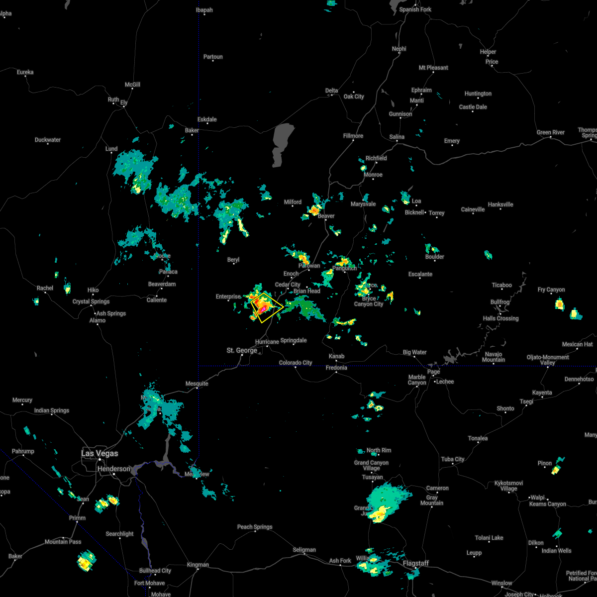
| 6/15/2023 2:34 PM MDT |
 At 233 pm mdt, a severe thunderstorm was located 8 miles northeast of new harmony, or 11 miles southwest of cedar city, moving southeast at 15 mph (radar indicated). Hazards include 60 mph wind gusts and half dollar size hail. Hail damage to vehicles is expected. expect wind damage to roofs, siding, and trees. locations impacted include, cedar city, kanarraville and hamilton fort. this includes the following highways, interstate 15 between mile markers 43 and 60. utah route 56 between mile markers 52 and 61. hail threat, radar indicated max hail size, 1. 25 in wind threat, radar indicated max wind gust, 60 mph. At 233 pm mdt, a severe thunderstorm was located 8 miles northeast of new harmony, or 11 miles southwest of cedar city, moving southeast at 15 mph (radar indicated). Hazards include 60 mph wind gusts and half dollar size hail. Hail damage to vehicles is expected. expect wind damage to roofs, siding, and trees. locations impacted include, cedar city, kanarraville and hamilton fort. this includes the following highways, interstate 15 between mile markers 43 and 60. utah route 56 between mile markers 52 and 61. hail threat, radar indicated max hail size, 1. 25 in wind threat, radar indicated max wind gust, 60 mph.
|
| 6/15/2023 2:13 PM MDT |
 At 212 pm mdt, a severe thunderstorm was located 7 miles north of new harmony, or 14 miles southwest of cedar city, moving southeast at 15 mph (radar indicated). Hazards include 60 mph wind gusts and half dollar size hail. Hail damage to vehicles is expected. Expect wind damage to roofs, siding, and trees. At 212 pm mdt, a severe thunderstorm was located 7 miles north of new harmony, or 14 miles southwest of cedar city, moving southeast at 15 mph (radar indicated). Hazards include 60 mph wind gusts and half dollar size hail. Hail damage to vehicles is expected. Expect wind damage to roofs, siding, and trees.
|
| 8/13/2021 4:20 PM MDT |
 At 419 pm mdt, a severe thunderstorm was located near new harmony, or 16 miles southwest of cedar city, and is nearly stationary (radar indicated). Hazards include quarter size hail. damage to vehicles is expected At 419 pm mdt, a severe thunderstorm was located near new harmony, or 16 miles southwest of cedar city, and is nearly stationary (radar indicated). Hazards include quarter size hail. damage to vehicles is expected
|
| 4/29/2019 7:41 PM MDT |
 A severe thunderstorm warning remains in effect until 800 pm mdt for northeastern washington and south central iron counties. at 741 pm mdt, a severe thunderstorm was located 8 miles south of cedar city, moving northeast at 35 mph. hazard. 60 mph wind gusts. source. Radar indicated. A severe thunderstorm warning remains in effect until 800 pm mdt for northeastern washington and south central iron counties. at 741 pm mdt, a severe thunderstorm was located 8 miles south of cedar city, moving northeast at 35 mph. hazard. 60 mph wind gusts. source. Radar indicated.
|
| 4/29/2019 7:12 PM MDT |
 At 711 pm mdt, a severe thunderstorm was located near pintura, or 23 miles southwest of cedar city, moving northeast at 30 mph (radar indicated). Hazards include 60 mph wind gusts. expect damage to roofs, siding, and trees At 711 pm mdt, a severe thunderstorm was located near pintura, or 23 miles southwest of cedar city, moving northeast at 30 mph (radar indicated). Hazards include 60 mph wind gusts. expect damage to roofs, siding, and trees
|
| 10/18/2015 2:49 PM MDT |
 At 248 pm mdt, doppler radar indicated a severe thunderstorm capable of producing quarter size hail and damaging winds in excess of 60 mph. this storm was located near new harmony, or 16 miles southwest of cedar city, moving northeast at 40 mph. this storm is capable of producing a significant amount of hail. hail may accumulate on area roads including i-15 resulting in dangerous travel conditions. locations impacted include, kanarraville, pintura and kolob canyon. At 248 pm mdt, doppler radar indicated a severe thunderstorm capable of producing quarter size hail and damaging winds in excess of 60 mph. this storm was located near new harmony, or 16 miles southwest of cedar city, moving northeast at 40 mph. this storm is capable of producing a significant amount of hail. hail may accumulate on area roads including i-15 resulting in dangerous travel conditions. locations impacted include, kanarraville, pintura and kolob canyon.
|
| 10/18/2015 2:39 PM MDT |
 At 239 pm mdt, doppler radar indicated a severe thunderstorm capable of producing quarter size hail and damaging winds in excess of 60 mph. this storm was located 7 miles southeast of new harmony, or 22 miles southwest of cedar city, and moving northeast at 40 mph. At 239 pm mdt, doppler radar indicated a severe thunderstorm capable of producing quarter size hail and damaging winds in excess of 60 mph. this storm was located 7 miles southeast of new harmony, or 22 miles southwest of cedar city, and moving northeast at 40 mph.
|
Hail Maps for Kanarraville, UT


Connect with Interactive Hail Maps