

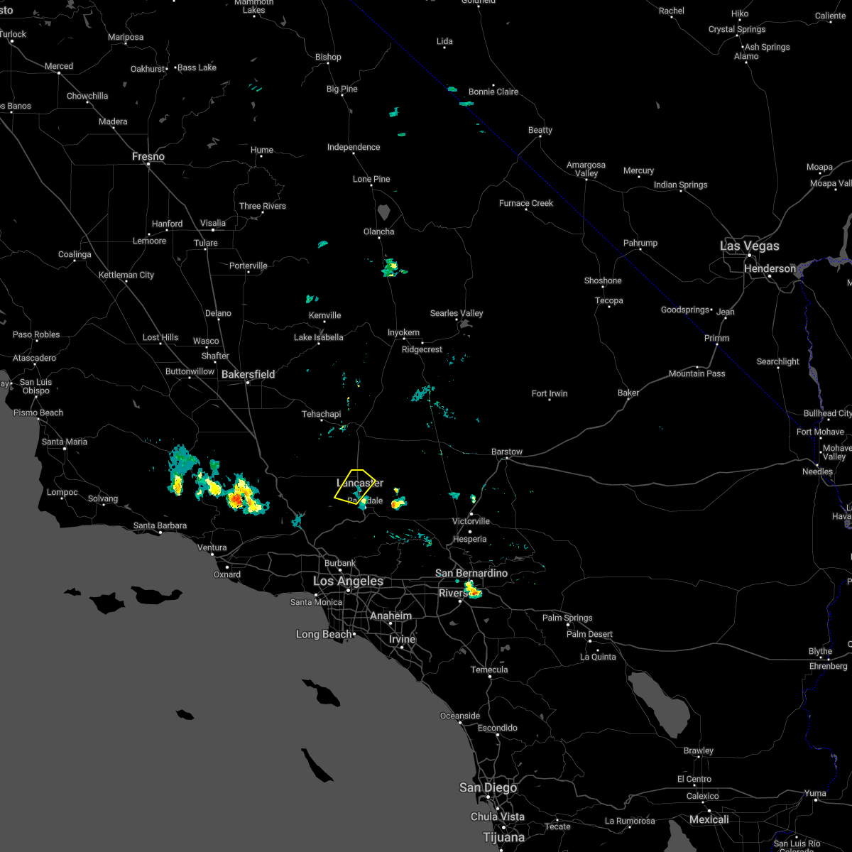
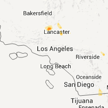
Hail Map for Lancaster, CA
The Lancaster, CA area has had 1 report of on-the-ground hail by trained spotters, and has been under severe weather warnings 0 times during the past 12 months. Doppler radar has detected hail at or near Lancaster, CA on 6 occasions.
| Name: | Lancaster, CA |
| Where Located: | 43.8 miles N of Los Angeles, CA |
| Map: | Google Map for Lancaster, CA |
| Population: | 156633 |
| Housing Units: | 51835 |
| More Info: | Search Google for Lancaster, CA |
0
The Top Recent Hail Date for Lancaster, CA is Sunday, September 4, 2022 (4th out of 6)

Hail and Wind Damage Spotted near Lancaster, CA
| Date / Time | Report Details |
|---|---|
| 9/12/2022 3:53 PM PDT | Telephone or power pole leaning in lane in los angeles county CA, 15.9 miles WSW of Lancaster, CA |
| 9/11/2022 7:03 PM PDT | Tree down in lanes at 45h s w/w avenue m in los angeles county CA, 3.3 miles N of Lancaster, CA |
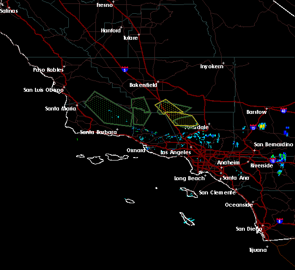
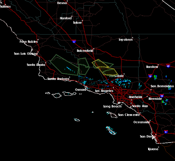
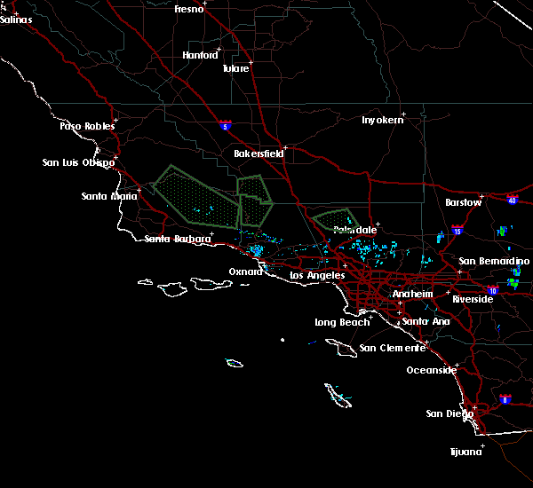
| 9/4/2022 4:54 PM PDT |
 At 454 pm pdt, a severe thunderstorm was located over lancaster, moving northwest at 30 mph (radar indicated). Hazards include 60 mph wind gusts and penny size hail. Expect damage to roofs, siding, and trees. locations impacted include, lancaster, palmdale, and quartz hill. hail threat, radar indicated max hail size, 0. 75 in wind threat, radar indicated max wind gust, 60 mph. At 454 pm pdt, a severe thunderstorm was located over lancaster, moving northwest at 30 mph (radar indicated). Hazards include 60 mph wind gusts and penny size hail. Expect damage to roofs, siding, and trees. locations impacted include, lancaster, palmdale, and quartz hill. hail threat, radar indicated max hail size, 0. 75 in wind threat, radar indicated max wind gust, 60 mph.
|
| 9/4/2022 4:37 PM PDT |
 At 437 pm pdt, a severe thunderstorm was located near palmdale, moving northwest at 15 mph (radar indicated). Hazards include 60 mph wind gusts and penny size hail. expect damage to roofs, siding, and trees At 437 pm pdt, a severe thunderstorm was located near palmdale, moving northwest at 15 mph (radar indicated). Hazards include 60 mph wind gusts and penny size hail. expect damage to roofs, siding, and trees
|
| 9/9/2017 8:02 PM PDT |
 At 801 pm pdt, a severe thunderstorm was located 7 miles northwest of lancaster, moving northwest around 20 mph (radar indicated). Hazards include 60 mph wind gusts and nickel size hail. Expect damage to roofs, siding, and trees. Locations impacted include, lancaster, palmdale, quartz hill, lake palmdale, lake hughes, elizabeth lake, desert view highlands, and highway 138 between quail lake and lancaster. At 801 pm pdt, a severe thunderstorm was located 7 miles northwest of lancaster, moving northwest around 20 mph (radar indicated). Hazards include 60 mph wind gusts and nickel size hail. Expect damage to roofs, siding, and trees. Locations impacted include, lancaster, palmdale, quartz hill, lake palmdale, lake hughes, elizabeth lake, desert view highlands, and highway 138 between quail lake and lancaster.
|
| 9/9/2017 7:44 PM PDT |
 At 743 pm pdt, a severe thunderstorm was located over lancaster, moving northwest around 20 mph (radar indicated). Hazards include 60 mph wind gusts and nickel size hail are possible with this storm. Expect damage to roofs, siding, and trees. Near zero visibility is possible in blowing dust. At 743 pm pdt, a severe thunderstorm was located over lancaster, moving northwest around 20 mph (radar indicated). Hazards include 60 mph wind gusts and nickel size hail are possible with this storm. Expect damage to roofs, siding, and trees. Near zero visibility is possible in blowing dust.
|
| 9/9/2017 7:43 PM PDT | Power outage in lancaster due to thunderstor in los angeles county CA, 3.5 miles SE of Lancaster, CA |
| 9/3/2017 3:45 PM PDT | Power lines down on 30th st. east and ave. m in lancaster/palmdale area. 30th st. east closed at this tim in los angeles county CA, 6.2 miles WNW of Lancaster, CA |
| 9/3/2017 2:56 PM PDT | East winds 25 mph gusting to 61 mph at saddleback butte raws...elevation 2590 fee in los angeles county CA, 22 miles W of Lancaster, CA |
| 3/7/2016 7:15 AM PST |
 At 715 am pst, doppler radar continued to indicate a line of severe thunderstorms capable of producing damaging winds. winds gusts up to 60 mph have been observed with this line of thunderstorms. these storms were located along a line extending from near littlerock to placentia, moving northeast at 45 mph. locations impacted include, chino, lake los angeles, wrightwood, whittier, san dimas, glendora, west covina, pomona, and chino hills. At 715 am pst, doppler radar continued to indicate a line of severe thunderstorms capable of producing damaging winds. winds gusts up to 60 mph have been observed with this line of thunderstorms. these storms were located along a line extending from near littlerock to placentia, moving northeast at 45 mph. locations impacted include, chino, lake los angeles, wrightwood, whittier, san dimas, glendora, west covina, pomona, and chino hills.
|
| 3/7/2016 6:53 AM PST |
 At 653 am pst, doppler radar indicated a line of severe thunderstorms capable of producing damaging winds in excess of 60 mph. these storms were located along a line extending from near acton to westminster, moving northeast at 45 mph. locations impacted include, long beach, chino, seal beach, lake los angeles, acton, wrightwood, whittier, griffith park, pasadena, downtown los angeles, san dimas, glendora, alhambra, west covina, burbank, pomona, mount wilson, hollywood, buena park, and chino hills. At 653 am pst, doppler radar indicated a line of severe thunderstorms capable of producing damaging winds in excess of 60 mph. these storms were located along a line extending from near acton to westminster, moving northeast at 45 mph. locations impacted include, long beach, chino, seal beach, lake los angeles, acton, wrightwood, whittier, griffith park, pasadena, downtown los angeles, san dimas, glendora, alhambra, west covina, burbank, pomona, mount wilson, hollywood, buena park, and chino hills.
|
| 3/7/2016 6:46 AM PST |
 At 646 am pst, doppler radar indicated a line of severe thunderstorms capable of producing damaging winds in excess of 60 mph. these storms were located along a line extending from near acton to near seal beach, and moving northeast at 45 mph. At 646 am pst, doppler radar indicated a line of severe thunderstorms capable of producing damaging winds in excess of 60 mph. these storms were located along a line extending from near acton to near seal beach, and moving northeast at 45 mph.
|
| 10/15/2015 5:29 PM PDT |
 At 523 pm pdt, doppler radar indicated a severe thunderstorm capable of producing ping pong ball size hail and damaging winds in excess of 60 mph. this storm was located over palmdale, leona valley and east lancaster, and drifting slowly eastward. At 523 pm pdt, doppler radar indicated a severe thunderstorm capable of producing ping pong ball size hail and damaging winds in excess of 60 mph. this storm was located over palmdale, leona valley and east lancaster, and drifting slowly eastward.
|
| 10/15/2015 4:44 PM PDT |
 At 435 pm pdt, doppler radar continued to indicated a severe thunderstorm over the central portion of the antelope valley, including the cities of leona valley, quartz hill, palmdale, and lancaster. this storm could produce large hail up to ping pong ball size, damaging winds in excess of 60 mph, frequent lightning, and very heavy rainfall. a flash flood emergency is also in effect for this storm as there have been numerous reports of severe flash flooding and debris flows. locations impacted include, palmdale, lancaster, quartz hill, and leona valley, and highways 14 and 138. At 435 pm pdt, doppler radar continued to indicated a severe thunderstorm over the central portion of the antelope valley, including the cities of leona valley, quartz hill, palmdale, and lancaster. this storm could produce large hail up to ping pong ball size, damaging winds in excess of 60 mph, frequent lightning, and very heavy rainfall. a flash flood emergency is also in effect for this storm as there have been numerous reports of severe flash flooding and debris flows. locations impacted include, palmdale, lancaster, quartz hill, and leona valley, and highways 14 and 138.
|
| 10/15/2015 4:23 PM PDT |
 At 416 pm pdt, doppler radar indicated a severe thunderstorm over the central portion of the antelope valley, including the cities of palmdale and lancaster. this storm could produce large hail up to ping pong ball size, damaging winds in excess of 60 mph, frequent lightning, and very heavy rainfall. as of 415 pm, the strongest portion of the storm was focused along highway 138 over palmdale, west of highway 14. a flash flood warning is also in effect for this storm as there have been numerous reports of flash flooding and debris flows. locations impacted include, palmdale, lancaster, leona valley, and highways 14 and 138. At 416 pm pdt, doppler radar indicated a severe thunderstorm over the central portion of the antelope valley, including the cities of palmdale and lancaster. this storm could produce large hail up to ping pong ball size, damaging winds in excess of 60 mph, frequent lightning, and very heavy rainfall. as of 415 pm, the strongest portion of the storm was focused along highway 138 over palmdale, west of highway 14. a flash flood warning is also in effect for this storm as there have been numerous reports of flash flooding and debris flows. locations impacted include, palmdale, lancaster, leona valley, and highways 14 and 138.
|
| 10/15/2015 4:01 PM PDT |
 At 354 pm pdt, doppler radar continues to indicate a severe thunderstorm capable of producing quarter size hail, damaging winds in excess of 60 mph, very heavy rainfalll, and frequent lighting across the central portion of the antelope valley, including lancaster and palmdale. storms are slowly drifting east. At 354 pm pdt, doppler radar continues to indicate a severe thunderstorm capable of producing quarter size hail, damaging winds in excess of 60 mph, very heavy rainfalll, and frequent lighting across the central portion of the antelope valley, including lancaster and palmdale. storms are slowly drifting east.
|
| 10/15/2015 3:27 PM PDT |
 At 319 pm pdt, doppler radar continued to indicate a cluster of severe thunderstorms capable of producing large damaging hail up to golf ball size and damaging winds in excess of 60 mph. there is a recent trained weather spotter reports of several funnel clouds being sighted. the storms were located near fairmont dam in the antelope valley and was located near lake hughes, or 5 miles north of castaic lake. these storm were nearly stationary. locations impacted include, elizabeth lake, lake hughes, gorman, highway 138 between quail lake and lancaster, interstate 5 over the grapevine, and pyramid lake. At 319 pm pdt, doppler radar continued to indicate a cluster of severe thunderstorms capable of producing large damaging hail up to golf ball size and damaging winds in excess of 60 mph. there is a recent trained weather spotter reports of several funnel clouds being sighted. the storms were located near fairmont dam in the antelope valley and was located near lake hughes, or 5 miles north of castaic lake. these storm were nearly stationary. locations impacted include, elizabeth lake, lake hughes, gorman, highway 138 between quail lake and lancaster, interstate 5 over the grapevine, and pyramid lake.
|
| 10/15/2015 3:06 PM PDT |
 At 302 pm pdt, doppler radar continued to indicate a cluster of severe thunderstorms capable of producing large damaging hail up to golf ball size and damaging winds in excess of 60 mph. these storms were moving northwest around 15 mph. locations impacted include, elizabeth lake, lake hughes, gorman, highway 138 between quail lake and lancaster, interstate 5 over the grapevine, and pyramid lake. At 302 pm pdt, doppler radar continued to indicate a cluster of severe thunderstorms capable of producing large damaging hail up to golf ball size and damaging winds in excess of 60 mph. these storms were moving northwest around 15 mph. locations impacted include, elizabeth lake, lake hughes, gorman, highway 138 between quail lake and lancaster, interstate 5 over the grapevine, and pyramid lake.
|
| 10/15/2015 2:48 PM PDT |
 At 245 pm pdt, national weather service doppler radar indicated a cluster of severe thunderstorms capable of producing quarter size hail and damaging winds in excess of 60 mph. these storms were located near lake hughes and sandberg and moving northwest around 15 mph. At 245 pm pdt, national weather service doppler radar indicated a cluster of severe thunderstorms capable of producing quarter size hail and damaging winds in excess of 60 mph. these storms were located near lake hughes and sandberg and moving northwest around 15 mph.
|
| 10/15/2015 12:02 AM PDT |
 At 1159 pm pdt, national weather service doppler radar continued to indicate a cluster of severe thunderstorms capable of producing quarter size hail and damaging winds in excess of 60 mph. these storm were located over the eastern antelope valley and moving northwest at 35 mph. locations impacted include, lake los angeles, pearblossom, llano, littlerock, valyermo, highway 138 between llano and the san bernardino county line, and saddleback butte state park. At 1159 pm pdt, national weather service doppler radar continued to indicate a cluster of severe thunderstorms capable of producing quarter size hail and damaging winds in excess of 60 mph. these storm were located over the eastern antelope valley and moving northwest at 35 mph. locations impacted include, lake los angeles, pearblossom, llano, littlerock, valyermo, highway 138 between llano and the san bernardino county line, and saddleback butte state park.
|
| 10/14/2015 11:44 PM PDT |
 At 1139 pm pdt, national weather service doppler radar continued to indicate a cluster of severe thunderstorms capable of producing quarter size hail and damaging winds in excess of 60 mph. there storm were located over the eastern antelope valley and eastern san gabriel range. locations impacted include, lake los angeles, pearblossom, llano, littlerock, valyermo, highway 138 between llano and the san bernardino county line, and saddleback butte state park. At 1139 pm pdt, national weather service doppler radar continued to indicate a cluster of severe thunderstorms capable of producing quarter size hail and damaging winds in excess of 60 mph. there storm were located over the eastern antelope valley and eastern san gabriel range. locations impacted include, lake los angeles, pearblossom, llano, littlerock, valyermo, highway 138 between llano and the san bernardino county line, and saddleback butte state park.
|
| 10/14/2015 11:31 PM PDT |
 At 1130 pm pdt, national weather service doppler radar indicated a cluster of severe thunderstorms capable of producing quarter size hail and damaging winds in excess of 60 mph. these storms were over the eastern portion of the antelope valley and the eastern san gabriel mountains, and moving northwest at 35 mph. At 1130 pm pdt, national weather service doppler radar indicated a cluster of severe thunderstorms capable of producing quarter size hail and damaging winds in excess of 60 mph. these storms were over the eastern portion of the antelope valley and the eastern san gabriel mountains, and moving northwest at 35 mph.
|
| 3/18/2015 8:07 PM PDT | A severe thunderstorm warning remains in effect until 830 pm pdt for north central los angeles county. at 800 pm pdt. national weather service doppler radar continued to indicate a severe thunderstorm capable of producing quarter size hail. this storm was located over north central los angeles county. or 16 miles southwest of lancaster. Moving west at 10 mph. |
| 3/18/2015 7:45 PM PDT | The national weather service in oxnard has issued a * severe thunderstorm warning for. north central los angeles county in southwest california. until 830 pm pdt * at 736 pm pdt. national weather service doppler radar indicated a severe thunderstorm capable of producing quarter size hail. This. |
| 3/18/2015 7:23 PM PDT | A severe thunderstorm warning remains in effect until 745 pm pdt for central los angeles county. at 718 pm pdt. national weather service doppler radar continued to indicate a severe thunderstorm capable of producing quarter size hail. this storm was located 8 miles north of acton. or 8 miles south of lancaster. Moving southwest at 20 mph. |
| 3/18/2015 7:09 PM PDT | The national weather service in oxnard has issued a * severe thunderstorm warning for. central los angeles county in southwest california. this includes the city of lancaster. until 745 pm pdt * at 700 pm pdt. National weather service doppler radar indicated. |
| 8/19/2013 4:30 PM PDT | Downed power lines reported near 4th east and east ave l in los angeles county CA, 5.3 miles WNW of Lancaster, CA |
| 1/1/0001 12:00 AM | Quarter sized hail reported 18.4 miles ESE of Lancaster, CA, time of occurrence was approximately 400 pm pdt. |
Hail Maps for Lancaster, CA


Connect with Interactive Hail Maps