

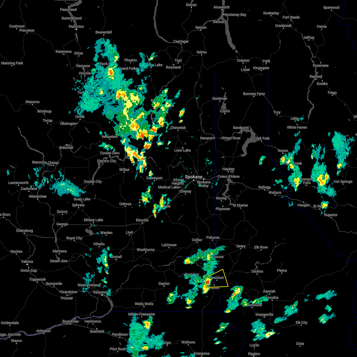
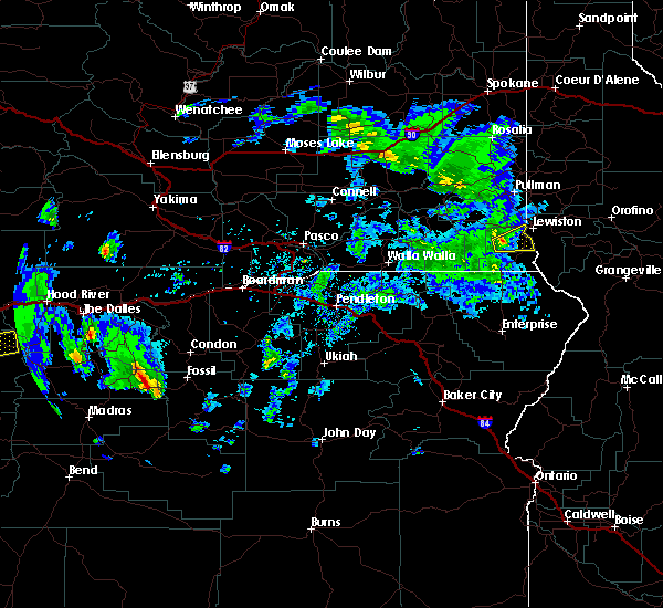
Hail Map for Lewiston, ID
The Lewiston, ID area has had 1 report of on-the-ground hail by trained spotters, and has been under severe weather warnings 0 times during the past 12 months. Doppler radar has detected hail at or near Lewiston, ID on 3 occasions.
| Name: | Lewiston, ID |
| Where Located: | 52.9 miles NW of Grangeville, ID |
| Map: | Google Map for Lewiston, ID |
| Population: | 31894 |
| Housing Units: | 14057 |
| More Info: | Search Google for Lewiston, ID |
0
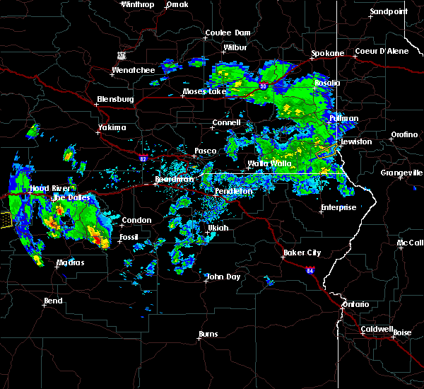
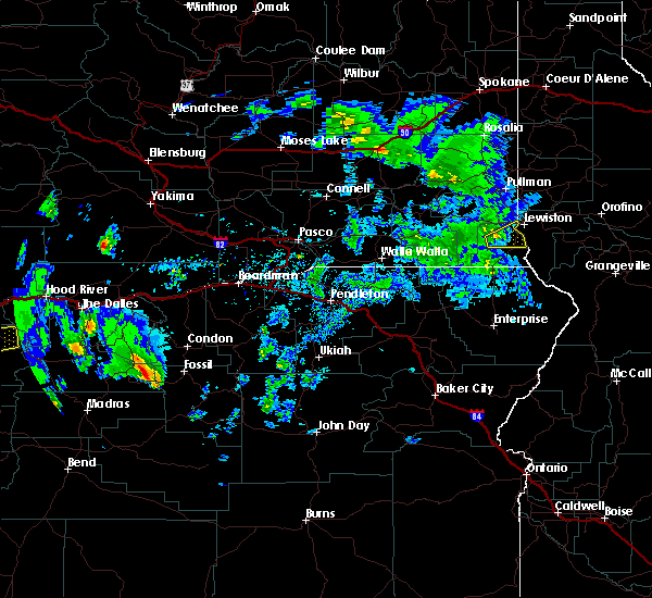
The Top Recent Hail Date for Lewiston, ID is Sunday, June 5, 2022 (3rd out of 3)

Hail and Wind Damage Spotted near Lewiston, ID
| Date / Time | Report Details |
|---|---|
| 6/9/2023 2:24 PM PDT | Downed power pole on snake river avenue. time based on rada in nez perce county ID, 1.9 miles ESE of Lewiston, ID |
| 6/9/2023 2:24 PM PDT | Downed power lines and blown transformers during thunderstorm. time estimated from rada in nez perce county ID, 1 miles ESE of Lewiston, ID |
| 6/5/2022 4:57 PM PDT |
 The severe thunderstorm warning for west central nez perce, southeastern whitman and northwestern asotin counties will expire at 500 pm pdt, the storm which prompted the warning has weakened below severe limits, and no longer poses an immediate threat to life or property. therefore, the warning will be allowed to expire. however heavy rain is still possible with this thunderstorm. The severe thunderstorm warning for west central nez perce, southeastern whitman and northwestern asotin counties will expire at 500 pm pdt, the storm which prompted the warning has weakened below severe limits, and no longer poses an immediate threat to life or property. therefore, the warning will be allowed to expire. however heavy rain is still possible with this thunderstorm.
|
| 6/5/2022 4:32 PM PDT |
 At 431 pm pdt, a severe thunderstorm was located near clarkston heights-vineland, or 8 miles west of clarkston, moving northeast at 15 mph (radar indicated). Hazards include quarter size hail. damage to vehicles is expected At 431 pm pdt, a severe thunderstorm was located near clarkston heights-vineland, or 8 miles west of clarkston, moving northeast at 15 mph (radar indicated). Hazards include quarter size hail. damage to vehicles is expected
|
| 6/3/2022 2:15 PM PDT |
 At 213 pm pdt, a severe thunderstorm was located near clarkston heights-vineland, or near clarkston, moving east at 15 mph (radar indicated). Hazards include quarter size hail. damage to vehicles is expected At 213 pm pdt, a severe thunderstorm was located near clarkston heights-vineland, or near clarkston, moving east at 15 mph (radar indicated). Hazards include quarter size hail. damage to vehicles is expected
|
| 5/6/2022 2:52 PM PDT | Wind gust reported from corral creek raw in nez perce county ID, 24.8 miles N of Lewiston, ID |
| 6/12/2020 7:53 PM PDT |
 The severe thunderstorm warning for southwestern latah, northwestern nez perce, eastern garfield, southeastern whitman and northeastern asotin counties will expire at 800 pm pdt, the severe thunderstorm which prompted the warning has weakened slightly but still poses a threat for hail and heavy rainfall. therefore, the warning will be allowed to expire at 800 pm. small hail and heavy rain are still possible with this thunderstorm. The severe thunderstorm warning for southwestern latah, northwestern nez perce, eastern garfield, southeastern whitman and northeastern asotin counties will expire at 800 pm pdt, the severe thunderstorm which prompted the warning has weakened slightly but still poses a threat for hail and heavy rainfall. therefore, the warning will be allowed to expire at 800 pm. small hail and heavy rain are still possible with this thunderstorm.
|
| 6/12/2020 7:14 PM PDT |
 At 713 pm pdt, a severe thunderstorm was located over clarkston heights-vineland, or near clarkston, moving northeast at 20 mph (radar indicated). Hazards include 60 mph wind gusts and quarter size hail. Hail damage to vehicles is expected. Expect wind damage to roofs, siding, and trees. At 713 pm pdt, a severe thunderstorm was located over clarkston heights-vineland, or near clarkston, moving northeast at 20 mph (radar indicated). Hazards include 60 mph wind gusts and quarter size hail. Hail damage to vehicles is expected. Expect wind damage to roofs, siding, and trees.
|
| 7/5/2019 7:25 PM PDT | Media reported a tree down due to thunderstorm wind gusts in lewiston... i in nez perce county ID, 2.5 miles ENE of Lewiston, ID |
| 7/5/2019 7:25 PM PDT | Avista reports 2400 customers without power in the lewiston/clarkston are in nez perce county ID, 2.2 miles ESE of Lewiston, ID |
| 6/26/2019 4:21 PM PDT |
 At 420 pm pdt, severe thunderstorms were located along a line extending from near lewiston to near lapwai to near winchester, moving northeast at 20 mph (radar indicated). Hazards include 60 mph wind gusts and dime to penny size hail. Hail damage to vehicles is expected. expect wind damage to roofs, siding, and trees. Locations impacted include, lapwai, culdesac, gifford, spalding and lenore. At 420 pm pdt, severe thunderstorms were located along a line extending from near lewiston to near lapwai to near winchester, moving northeast at 20 mph (radar indicated). Hazards include 60 mph wind gusts and dime to penny size hail. Hail damage to vehicles is expected. expect wind damage to roofs, siding, and trees. Locations impacted include, lapwai, culdesac, gifford, spalding and lenore.
|
| 6/26/2019 4:18 PM PDT | Report from waha grill of dime hail... est 50 mph winds and tree limb damag in nez perce county ID, 14.4 miles NNW of Lewiston, ID |
| 6/26/2019 4:11 PM PDT |
 At 410 pm pdt, severe thunderstorms were located along a line extending from near clarkston heights-vineland to 7 miles south of lapwai to 7 miles southwest of winchester, moving northeast at 20 mph (radar indicated). Hazards include 60 mph wind gusts and quarter size hail. Hail damage to vehicles is expected. expect wind damage to roofs, siding, and trees. Locations impacted include, lewiston, clarkston, lapwai, culdesac, clarkston heights-vineland, west clarkston-highland, asotin, colton, uniontown, spalding, waha, gifford, clarkston heights, jerry and lenore. At 410 pm pdt, severe thunderstorms were located along a line extending from near clarkston heights-vineland to 7 miles south of lapwai to 7 miles southwest of winchester, moving northeast at 20 mph (radar indicated). Hazards include 60 mph wind gusts and quarter size hail. Hail damage to vehicles is expected. expect wind damage to roofs, siding, and trees. Locations impacted include, lewiston, clarkston, lapwai, culdesac, clarkston heights-vineland, west clarkston-highland, asotin, colton, uniontown, spalding, waha, gifford, clarkston heights, jerry and lenore.
|
| 6/26/2019 4:11 PM PDT |
 At 350 pm pdt, severe thunderstorms were located along a line extending from 12 miles south of clarkston heights-vineland to 13 miles south of lewiston to 14 miles southwest of winchester, moving northeast at 60 mph (radar indicated). Hazards include 60 mph wind gusts. expect damage to roofs, siding, and trees At 350 pm pdt, severe thunderstorms were located along a line extending from 12 miles south of clarkston heights-vineland to 13 miles south of lewiston to 14 miles southwest of winchester, moving northeast at 60 mph (radar indicated). Hazards include 60 mph wind gusts. expect damage to roofs, siding, and trees
|
| 6/26/2019 3:52 PM PDT | Power lines down reported at 431 burrell avenue... lewiston... i in nez perce county ID, 1.3 miles NE of Lewiston, ID |
| 6/26/2019 3:50 PM PDT |
 At 350 pm pdt, severe thunderstorms were located along a line extending from 12 miles south of clarkston heights-vineland to 13 miles south of lewiston to 14 miles southwest of winchester, moving northeast at 60 mph (radar indicated). Hazards include 60 mph wind gusts. expect damage to roofs, siding, and trees At 350 pm pdt, severe thunderstorms were located along a line extending from 12 miles south of clarkston heights-vineland to 13 miles south of lewiston to 14 miles southwest of winchester, moving northeast at 60 mph (radar indicated). Hazards include 60 mph wind gusts. expect damage to roofs, siding, and trees
|
| 6/26/2019 3:47 PM PDT | Power lines down reported at 630 20th avenue... lewiston... i in nez perce county ID, 1.5 miles ESE of Lewiston, ID |
| 6/26/2019 3:38 PM PDT |
 At 338 pm pdt, a severe thunderstorm was located near clarkston heights-vineland, or 7 miles southwest of clarkston, moving northeast at 15 mph (radar indicated). Hazards include 60 mph wind gusts and penny size hail. Expect damage to roofs, siding, and trees. Locations impacted include, clarkston, clarkston heights-vineland, west clarkston-highland, clarkston heights and jerry. At 338 pm pdt, a severe thunderstorm was located near clarkston heights-vineland, or 7 miles southwest of clarkston, moving northeast at 15 mph (radar indicated). Hazards include 60 mph wind gusts and penny size hail. Expect damage to roofs, siding, and trees. Locations impacted include, clarkston, clarkston heights-vineland, west clarkston-highland, clarkston heights and jerry.
|
| 6/26/2019 3:30 PM PDT |
 At 329 pm pdt, a severe thunderstorm was located 7 miles southwest of clarkston heights-vineland, or 9 miles southwest of clarkston, moving northeast at 15 mph (radar indicated). Hazards include 60 mph wind gusts and penny size hail. Expect damage to roofs, siding, and trees. Locations impacted include, clarkston, clarkston heights-vineland, west clarkston-highland, clarkston heights, cloverland and jerry. At 329 pm pdt, a severe thunderstorm was located 7 miles southwest of clarkston heights-vineland, or 9 miles southwest of clarkston, moving northeast at 15 mph (radar indicated). Hazards include 60 mph wind gusts and penny size hail. Expect damage to roofs, siding, and trees. Locations impacted include, clarkston, clarkston heights-vineland, west clarkston-highland, clarkston heights, cloverland and jerry.
|
| 6/26/2019 3:22 PM PDT |
 At 321 pm pdt, a severe thunderstorm was located 8 miles southwest of clarkston heights-vineland, or 11 miles southwest of clarkston, moving east northeast at 15 mph (radar indicated). Hazards include 60 mph wind gusts and penny size hail. Expect damage to roofs, siding, and trees. Locations impacted include, clarkston, clarkston heights-vineland, west clarkston-highland, asotin, clarkston heights, cloverland and jerry. At 321 pm pdt, a severe thunderstorm was located 8 miles southwest of clarkston heights-vineland, or 11 miles southwest of clarkston, moving east northeast at 15 mph (radar indicated). Hazards include 60 mph wind gusts and penny size hail. Expect damage to roofs, siding, and trees. Locations impacted include, clarkston, clarkston heights-vineland, west clarkston-highland, asotin, clarkston heights, cloverland and jerry.
|
| 6/26/2019 3:18 PM PDT |
 At 317 pm pdt, a severe thunderstorm was located 10 miles southwest of clarkston heights-vineland, or 12 miles southwest of clarkston, moving east northeast at 15 mph (radar indicated). Hazards include 60 mph wind gusts and penny size hail. expect damage to roofs, siding, and trees At 317 pm pdt, a severe thunderstorm was located 10 miles southwest of clarkston heights-vineland, or 12 miles southwest of clarkston, moving east northeast at 15 mph (radar indicated). Hazards include 60 mph wind gusts and penny size hail. expect damage to roofs, siding, and trees
|
| 4/7/2017 8:00 AM PDT | Brief wind gusts to 66 mph... with estimated sustained near 50 mph. some power outages reported in nez perce count in nez perce county ID, 4 miles WSW of Lewiston, ID |
| 6/8/2016 3:06 PM PDT |
 At 306 pm pdt, doppler radar indicated a severe thunderstorm capable of producing quarter size hail. this storm was located near lewiston, and moving northeast at 35 mph. At 306 pm pdt, doppler radar indicated a severe thunderstorm capable of producing quarter size hail. this storm was located near lewiston, and moving northeast at 35 mph.
|
| 5/31/2015 10:33 PM PDT | At 1026 pm pdt, doppler radar indicated a line of severe thunderstorms capable of producing damaging winds around 55 mph. these storms were located along a line extending from 7 miles east of pomeroy to 6 miles west of clarkston heights-vineland to 16 miles south of west clarkston-highland, and moving northeast at 30 mph. penny size hail may also accompany the strong winds. |
| 5/31/2015 10:33 PM PDT | At 1026 pm pdt, doppler radar indicated a line of severe thunderstorms capable of producing damaging winds around 55 mph. these storms were located along a line extending from 7 miles east of pomeroy to 6 miles west of clarkston heights-vineland to 16 miles south of west clarkston-highland, and moving northeast at 30 mph. penny size hail may also accompany the strong winds. |
| 5/31/2015 10:24 PM PDT | At 1019 pm pdt, doppler radar indicated a line of severe thunderstorms capable of producing hail to around dime size, and winds up to 60 mph. these storms were located along a line extending from 11 miles south of pullman to near genesee to 8 miles south of lewiston, moving east at 30 mph. this warning will likely be extended beyond 1030 pm pdt. lewiston is still in the direct patch of this storm. locations impacted include, lewiston, clarkston, pomeroy, west clarkston-highland, clarkston heights-vineland, asotin, colton, uniontown, cloverland, wickiup campground, jerry, clarkston heights and peola. |
| 5/31/2015 10:24 PM PDT | At 1019 pm pdt, doppler radar indicated a line of severe thunderstorms capable of producing hail to around dime size, and winds up to 60 mph. these storms were located along a line extending from 11 miles south of pullman to near genesee to 8 miles south of lewiston, moving east at 30 mph. this warning will likely be extended beyond 1030 pm pdt. lewiston is still in the direct patch of this storm. locations impacted include, lewiston, clarkston, pomeroy, west clarkston-highland, clarkston heights-vineland, asotin, colton, uniontown, cloverland, wickiup campground, jerry, clarkston heights and peola. |
| 5/31/2015 9:33 PM PDT | At 932 pm pdt, doppler radar indicated a line of severe thunderstorms capable of producing quarter size hail and damaging winds in excess of 60 mph. these storms were located along a line extending from near pomeroy to 15 miles west of clarkston heights-vineland to 14 miles north of troy, and moving northeast at 40 mph. |
| 5/31/2015 9:33 PM PDT | At 932 pm pdt, doppler radar indicated a line of severe thunderstorms capable of producing quarter size hail and damaging winds in excess of 60 mph. these storms were located along a line extending from near pomeroy to 15 miles west of clarkston heights-vineland to 14 miles north of troy, and moving northeast at 40 mph. |
| 5/31/2015 8:00 PM PDT | A number of reports of tree limbs blown onto roads and into power lines causing power outages between 8 pm and 1030 p in nez perce county ID, 0.2 miles N of Lewiston, ID |
| 6/2/2014 5:06 PM PDT | Storm damage reported in nez perce county ID, 0.2 miles N of Lewiston, ID |
| 7/20/2012 12:48 PM PDT | Quarter sized hail reported 2.2 miles NW of Lewiston, ID, spotter nez perce 33. |
| 1/1/0001 12:00 AM | Delayed report of wind damage in the eagle point subdivision approximately 4 miles east of lewiston. a section of a roof from a pole outbuilding was torn off. roughly t in nez perce county ID, 3.9 miles W of Lewiston, ID |
| 1/1/0001 12:00 AM | Delayed report of wind damage to building. time estimated. klew t in nez perce county ID, 3.9 miles W of Lewiston, ID |
Hail Maps for Lewiston, ID


Connect with Interactive Hail Maps