

Hail Map for Low Mountain, AZ
The Low Mountain, AZ area has had 0 reports of on-the-ground hail by trained spotters, and has been under severe weather warnings 0 times during the past 12 months. Doppler radar has detected hail at or near Low Mountain, AZ on 5 occasions, including 2 occasions during the past year.
| Name: | Low Mountain, AZ |
| Where Located: | 101.6 miles ENE of Flagstaff, AZ |
| Map: | Google Map for Low Mountain, AZ |
| Population: | 757 |
| Housing Units: | 260 |
| More Info: | Search Google for Low Mountain, AZ |
0
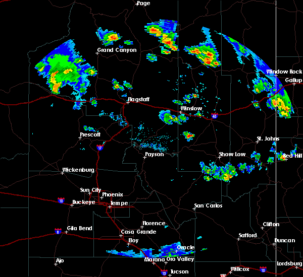
The Top Recent Hail Date for Low Mountain, AZ is Thursday, August 10, 2023 (5th out of 5)

Hail and Wind Damage Spotted near Low Mountain, AZ
| Date / Time | Report Details |
|---|---|
| 7/29/2021 2:41 PM MDT |
 The severe thunderstorm warning for apache and navajo counties will expire at 145 pm mst/245 pm mdt/, the thunderstorm which prompted the severe thunderstorm warning near salina has weakened. therefore, the warning will be allowed to expire. however, small hail and very heavy rain are still possible with this thunderstorm from salina to areas west of pinon. The severe thunderstorm warning for apache and navajo counties will expire at 145 pm mst/245 pm mdt/, the thunderstorm which prompted the severe thunderstorm warning near salina has weakened. therefore, the warning will be allowed to expire. however, small hail and very heavy rain are still possible with this thunderstorm from salina to areas west of pinon.
|
| 7/29/2021 2:07 PM MDT |
 At 106 pm mst/206 pm mdt/, a severe thunderstorm was located near whippoorwill chapter house, or 19 miles northeast of keams canyon, moving northwest at 35 mph (radar indicated). Hazards include 60 mph wind gusts and half dollar size hail. Hail damage to vehicles is expected. Expect wind damage to roofs, siding, and trees. At 106 pm mst/206 pm mdt/, a severe thunderstorm was located near whippoorwill chapter house, or 19 miles northeast of keams canyon, moving northwest at 35 mph (radar indicated). Hazards include 60 mph wind gusts and half dollar size hail. Hail damage to vehicles is expected. Expect wind damage to roofs, siding, and trees.
|
| 5/15/2021 3:28 PM MDT |
 The severe thunderstorm warning for apache and navajo counties will expire at 330 pm mdt, the severe thunderstorm near salina and cottonwood, in apache county, has weakened below severe limits, and no longer poses an immediate threat to life or property. therefore, the warning will be allowed to expire. gusty winds to 45 mph and light showers remain possible in this area until 4 pm mdt. The severe thunderstorm warning for apache and navajo counties will expire at 330 pm mdt, the severe thunderstorm near salina and cottonwood, in apache county, has weakened below severe limits, and no longer poses an immediate threat to life or property. therefore, the warning will be allowed to expire. gusty winds to 45 mph and light showers remain possible in this area until 4 pm mdt.
|
| 5/15/2021 3:03 PM MDT |
 At 302 pm mdt, a severe thunderstorm was located near low mountain, or 14 miles northeast of keams canyon, moving northeast at 30 mph (radar indicated). Hazards include 60 mph wind gusts. Expect damage to roofs, siding, and trees. this severe thunderstorm will be near, salina around 320 pm mdt. tselani-cottonwood around 325 pm mdt. Blue gap chapter house around 330 pm mdt. At 302 pm mdt, a severe thunderstorm was located near low mountain, or 14 miles northeast of keams canyon, moving northeast at 30 mph (radar indicated). Hazards include 60 mph wind gusts. Expect damage to roofs, siding, and trees. this severe thunderstorm will be near, salina around 320 pm mdt. tselani-cottonwood around 325 pm mdt. Blue gap chapter house around 330 pm mdt.
|
| 7/25/2019 6:24 PM MST |
 The severe thunderstorm warning for apache and navajo counties will expire at 630 pm mst/730 pm mdt/, the storm which prompted the warning has weakened below severe limits, and no longer poses an immediate threat to life or property. therefore, the warning will be allowed to expire. however gusty winds and heavy rain are still possible with this thunderstorm. The severe thunderstorm warning for apache and navajo counties will expire at 630 pm mst/730 pm mdt/, the storm which prompted the warning has weakened below severe limits, and no longer poses an immediate threat to life or property. therefore, the warning will be allowed to expire. however gusty winds and heavy rain are still possible with this thunderstorm.
|
| 7/25/2019 6:18 PM MST |
 At 617 pm mst/717 pm mdt/, a strong thunderstorm was still located near low mountain, or 7 miles northeast of keams canyon, moving northeast at 15 mph. this storm has weakened but will continue to pose a risk for hail and gusty winds (radar indicated). Hazards include 60 mph wind gusts and quarter size hail. Hail damage to vehicles is expected. expect wind damage to roofs, siding, and trees. Locations impacted include, keams canyon, low mountain, jadito and jeddito. At 617 pm mst/717 pm mdt/, a strong thunderstorm was still located near low mountain, or 7 miles northeast of keams canyon, moving northeast at 15 mph. this storm has weakened but will continue to pose a risk for hail and gusty winds (radar indicated). Hazards include 60 mph wind gusts and quarter size hail. Hail damage to vehicles is expected. expect wind damage to roofs, siding, and trees. Locations impacted include, keams canyon, low mountain, jadito and jeddito.
|
| 7/25/2019 6:02 PM MST |
 At 602 pm mst/702 pm mdt/, a severe thunderstorm was located near keams canyon, moving northeast at 15 mph (radar indicated). Hazards include 60 mph wind gusts and quarter size hail. Hail damage to vehicles is expected. Expect wind damage to roofs, siding, and trees. At 602 pm mst/702 pm mdt/, a severe thunderstorm was located near keams canyon, moving northeast at 15 mph (radar indicated). Hazards include 60 mph wind gusts and quarter size hail. Hail damage to vehicles is expected. Expect wind damage to roofs, siding, and trees.
|
| 7/1/2015 4:36 PM MST |
 At 435 pm mst, doppler radar indicated a severe thunderstorm capable of producing quarter size hail and damaging winds in excess of 60 mph. this storm was located about 5 miles southwest of pinon, or 13 miles northwest of keams canyon, moving west at 15 mph. this severe thunderstorm will remain over mainly rural areas of central navajo county, south and southwest of pinon. At 435 pm mst, doppler radar indicated a severe thunderstorm capable of producing quarter size hail and damaging winds in excess of 60 mph. this storm was located about 5 miles southwest of pinon, or 13 miles northwest of keams canyon, moving west at 15 mph. this severe thunderstorm will remain over mainly rural areas of central navajo county, south and southwest of pinon.
|
| 7/1/2015 5:15 PM MDT |
 At 413 pm mst, doppler radar indicated a severe thunderstorm capable of producing quarter size hail and damaging winds in excess of 60 mph. this storm was located 2 miles south of pinon arizona, or 16 miles north of keams canyon, and moving west at 15 mph. At 413 pm mst, doppler radar indicated a severe thunderstorm capable of producing quarter size hail and damaging winds in excess of 60 mph. this storm was located 2 miles south of pinon arizona, or 16 miles north of keams canyon, and moving west at 15 mph.
|
| 6/29/2015 6:39 PM MDT |
 At 538 pm mst, doppler radar indicated a severe thunderstorm capable of producing damaging winds in excess of 60 mph. this storm was located near pinon and was moving southwest at 5 to 10 mph. penny size hail may also accompany the damaging winds. locations impacted include, pinon. At 538 pm mst, doppler radar indicated a severe thunderstorm capable of producing damaging winds in excess of 60 mph. this storm was located near pinon and was moving southwest at 5 to 10 mph. penny size hail may also accompany the damaging winds. locations impacted include, pinon.
|
| 6/29/2015 6:20 PM MDT |
 At 519 pm mst, doppler radar indicated a severe thunderstorm capable of producing damaging winds in excess of 60 mph. this storm was located 2 miles north of pinon and was moving southwest at 20 mph. penny size hail may also accompany the damaging winds. At 519 pm mst, doppler radar indicated a severe thunderstorm capable of producing damaging winds in excess of 60 mph. this storm was located 2 miles north of pinon and was moving southwest at 20 mph. penny size hail may also accompany the damaging winds.
|
Hail Maps for Low Mountain, AZ


Connect with Interactive Hail Maps